Texas Weather Whirlwind: Sunny Days and Stormy Nights
By
Amy Freeze
Explore a comprehensive breakdown of Austin's weather forecast and read about storm patterns across the Southern Plains that could affect your week.
Catch the latest weather updates in Austin! From sizzling highs to evening breezes and storm alerts across the Southern Plains, stay ahead with our comprehensive guide.
This week in the Southern Plains, including Austin, we’re experiencing a mix of scorching temperatures and stormy outbreaks. Monday kicks off with partly cloudy skies and a high of 95 degrees in Austin, while scattered thunderstorms mark the weather for the following days. Each city within the Southern Plains faces its unique weather challenges, making it essential to stay updated. For detailed forecasts, safety tips, and how to prepare for summer storms, visit our full blog post.
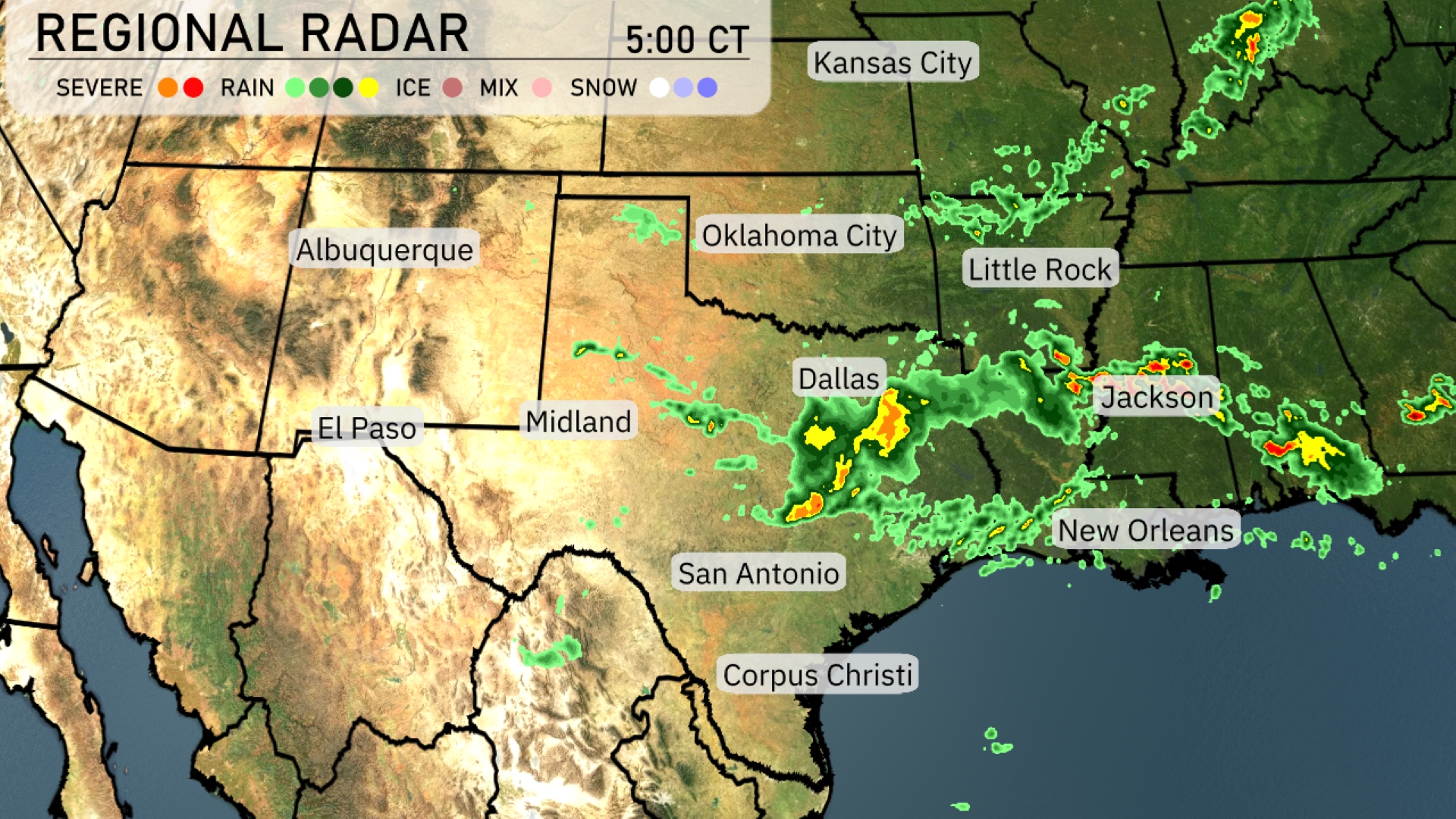
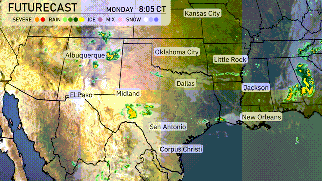
In the Southern Plains region, the radar reveals a robust line of thunderstorms sweeping through northeast Texas towards Little Rock, Arkansas, bringing intense rainfall. Oklahoma City is currently experiencing overcast skies, with scattered showers briskly making their way toward Dallas. San Antonio and Corpus Christi remain clear, as do the skies over New Orleans, providing a brief break from the current storm activity along the Gulf Coast. Jackson is sitting under a band of rain.
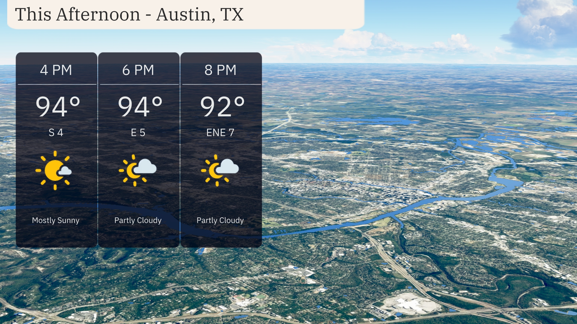
Austin’s afternoon will reach high temperatures around 94 degrees, with a shift in wind direction from south at 4 PM to east by 6 PM, maintaining speeds between 4 and 5 miles per hour. Expect mostly sunny conditions early, gradually transitioning to partly cloudy skies later in the afternoon. By 8 PM, temperatures will slightly decrease to 92 degrees as winds turn east-northeast at 7 miles per hour.
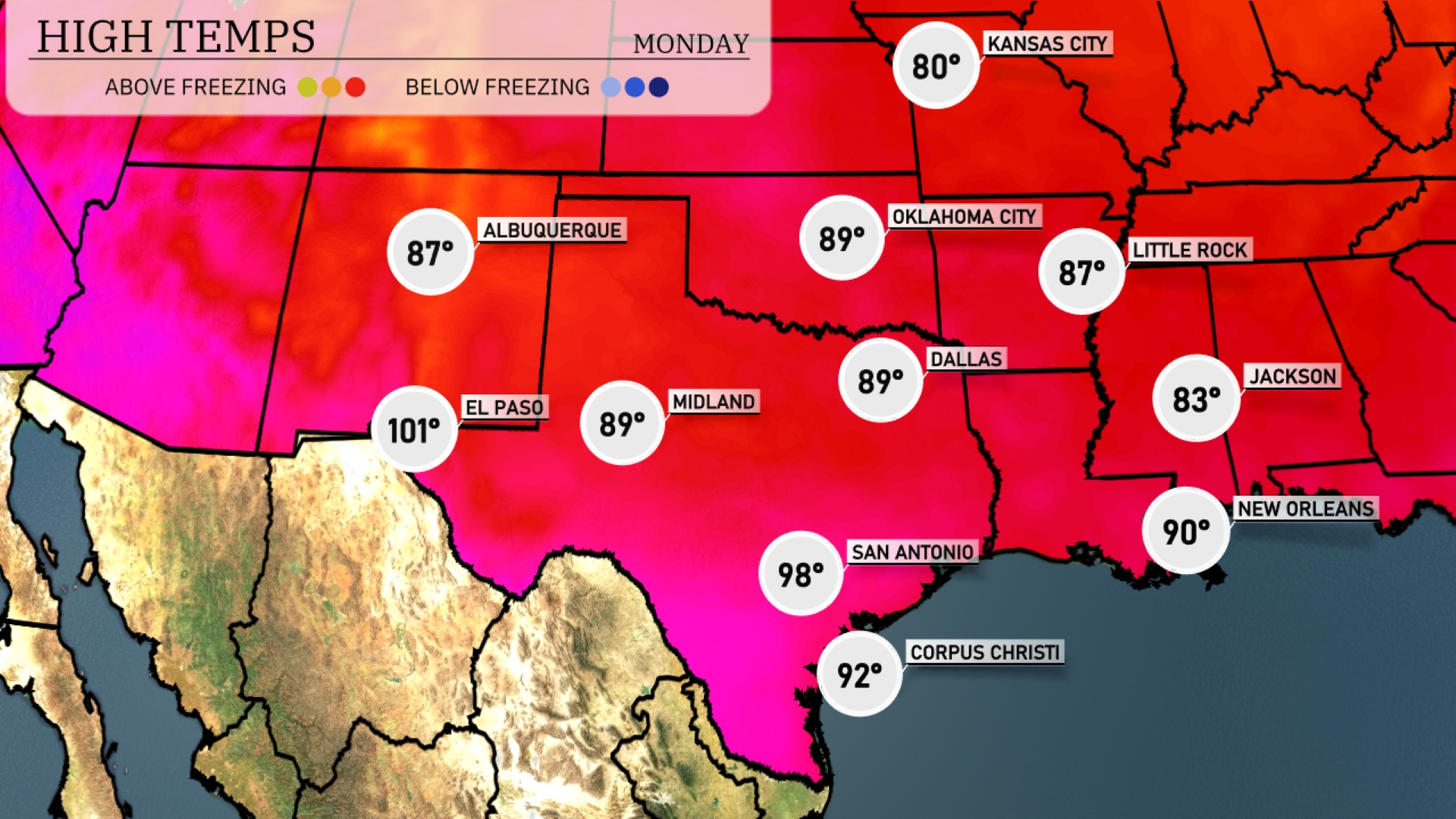
Today in the Southern Plains, temperatures are heating up nicely. El Paso will see a warm high of 101 degrees, while Midland will reach 89. In Texas’s major cities, Dallas is expecting a high of 89, and San Antonio is a bit warmer at 98. Over in New Orleans, a balmy high of 90 degrees is on tap, while Jackson will stay cooler at 83.
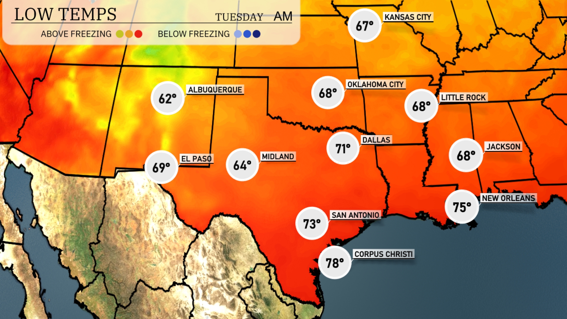
Tonight, Oklahoma City will drop to a low of 68 degrees, while Dallas is expected to see 71. Midland will cool down to 64 degrees, and El Paso will sit at 69. Expect slightly warmer temps in San Antonio at 73 and a balmy 78 in Corpus Christi.
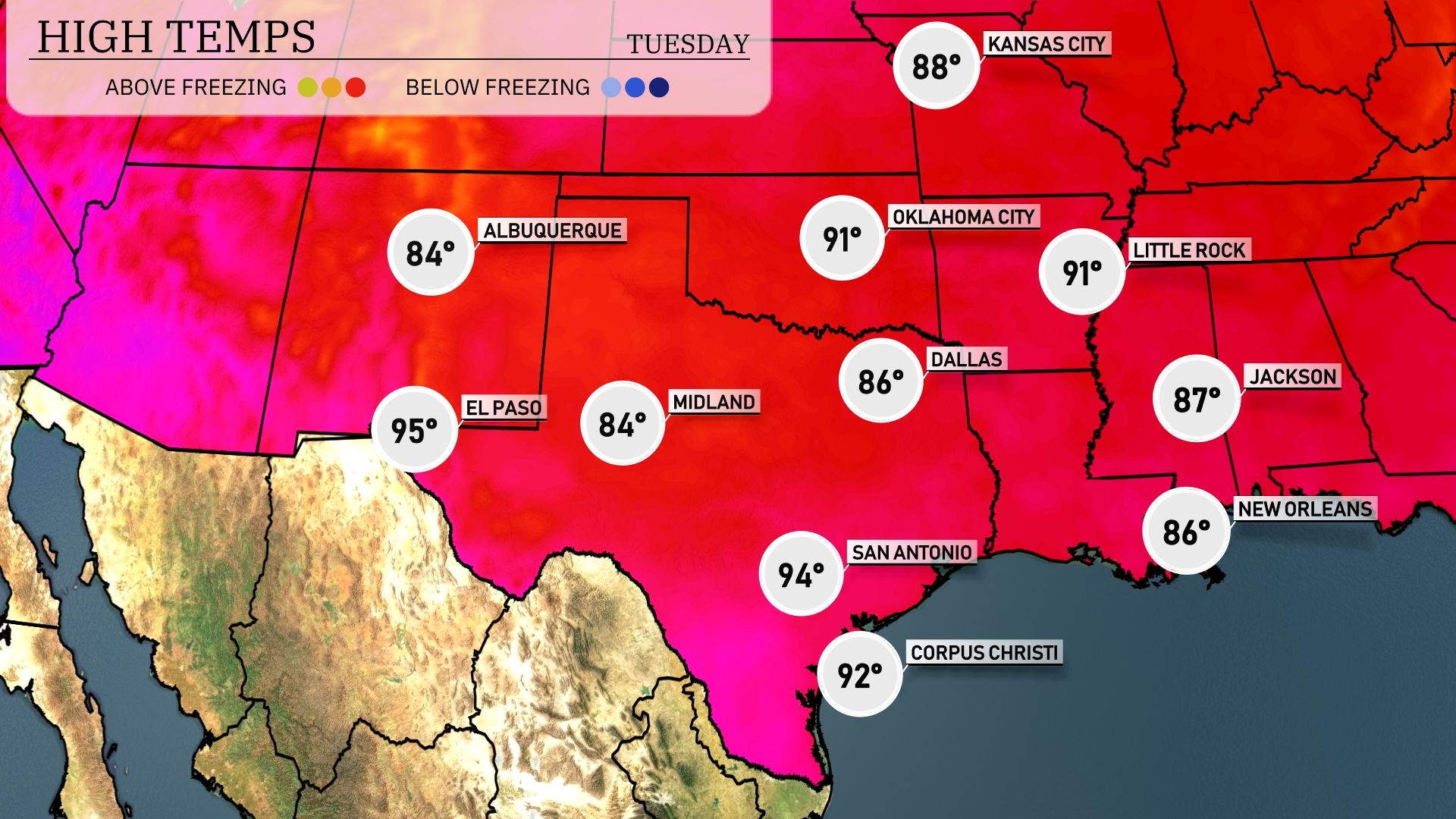
Tomorrow in the Southern Plains, expect a warm day with El Paso reaching a sizzling 95 degrees. Midland will see a high of 84, while Dallas warms up to 86. San Antonio will experience a pleasant 94, and Corpus Christi is forecasted for 92 degrees. Highs across the region are generally above average due to a dominant high-pressure system, leading to a few more days of summer-like temperatures.
In the Southern Plains, Tuesday brings morning rain showers stretching from Dallas to Corpus Christi, offering some relief amidst ongoing dry conditions. Oklahoma City and its surrounding areas should brace for potentially severe thunderstorms due to a persistent unstable air mass paired with an advancing cold front. Prepare for strong winds and possible hail, especially in eastern Oklahoma. By late evening, the storm system moves eastward, impacting areas from Little Rock to Jackson, with heavy downpours expected. After the front passes, look forward to clearer skies and refreshing cooler temperatures into Wednesday.
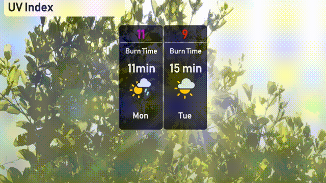
In Austin, Monday’s UV index is extremely high at 11, resulting in a quick burn time of just 11 minutes. On Tuesday, the UV index decreases slightly to 9, with a burn time of about 15 minutes.