Storm Fronts and Sunscreen: Miami’s Unpredictable Weather Week
By
Amy Freeze
Explore the dynamic weather patterns sweeping through Miami and the Southeast. From steamy highs to stormy skies, understand what this means for your week ahead.
This week in Miami, expect a roller-coaster of weather conditions, from partly cloudy to thunderstorms, with a detailed look at temperatures and precautions for extreme UV levels.
In this detailed post, we delve deep into the Southeast’s current weather situation. Miami sees partly cloudy skies and fluctuating temperatures, while a storm front in Jacksonville heads towards the Panhandle. With anticipated severe storms and a breakdown of daily conditions, we offer insights into how these patterns might affect your plans and health.
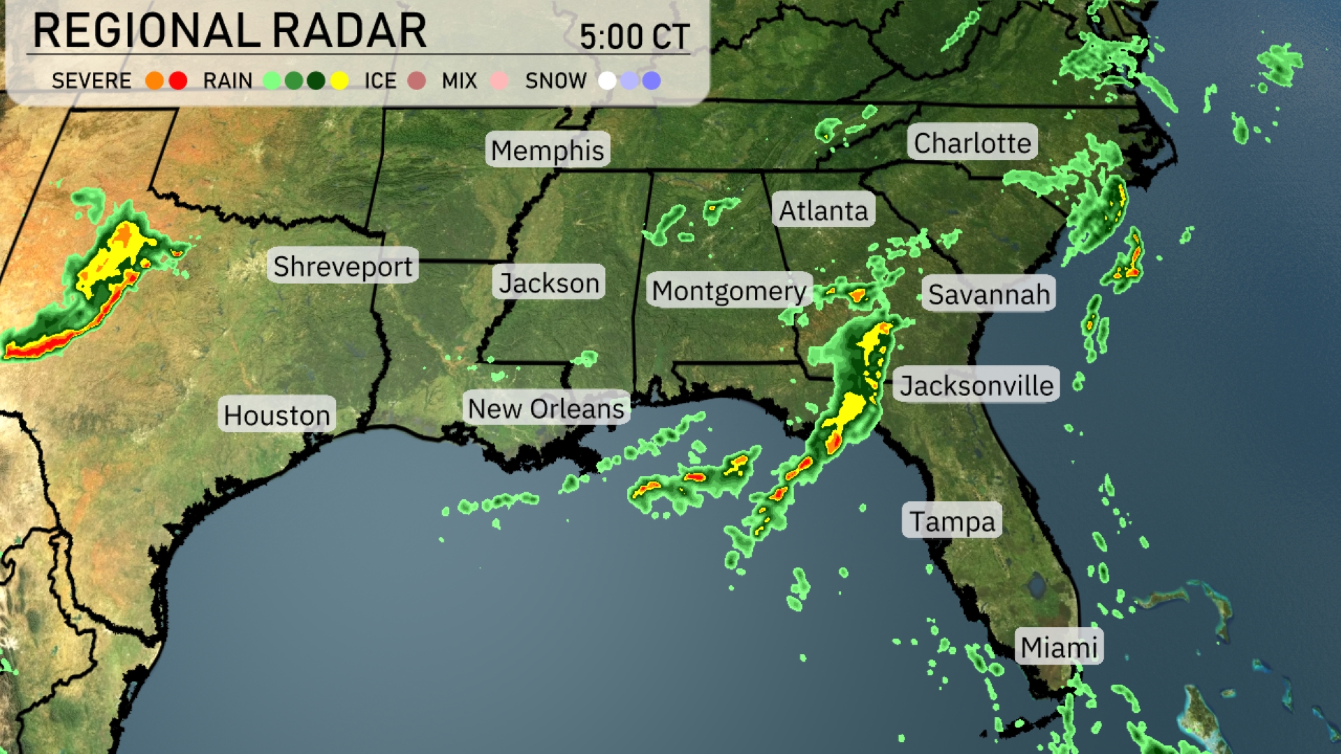
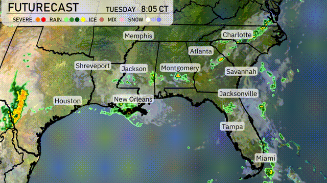
Across the Southeast, an active weather pattern is unfolding. The radar shows a line of strong storms pushing through Jacksonville, with heavy rain stretching along the Florida Panhandle. There’s moderate rainfall just north of Montgomery, moving towards Birmingham. The skies over Charlotte and Atlanta remain cloudy, with rain still edging closer to these cities.
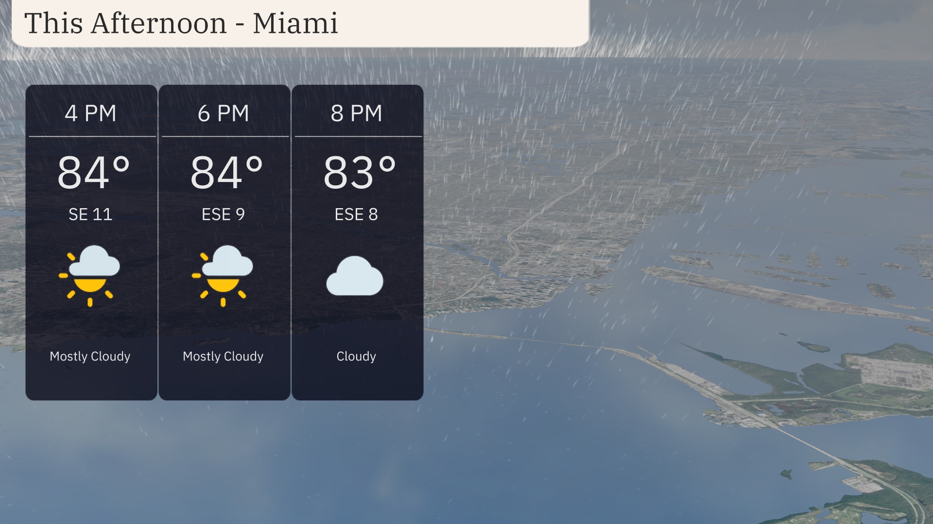
Afternoon temperatures in Miami will hold steady around 84 degrees with a mostly cloudy sky. Winds will be coming from the east-southeast, starting at 11 mph and decreasing slightly to 9 mph by 6 PM. As the evening approaches, expect the clouds to persist as temperatures dip slightly to 83 degrees with an ESE breeze at 8 mph.
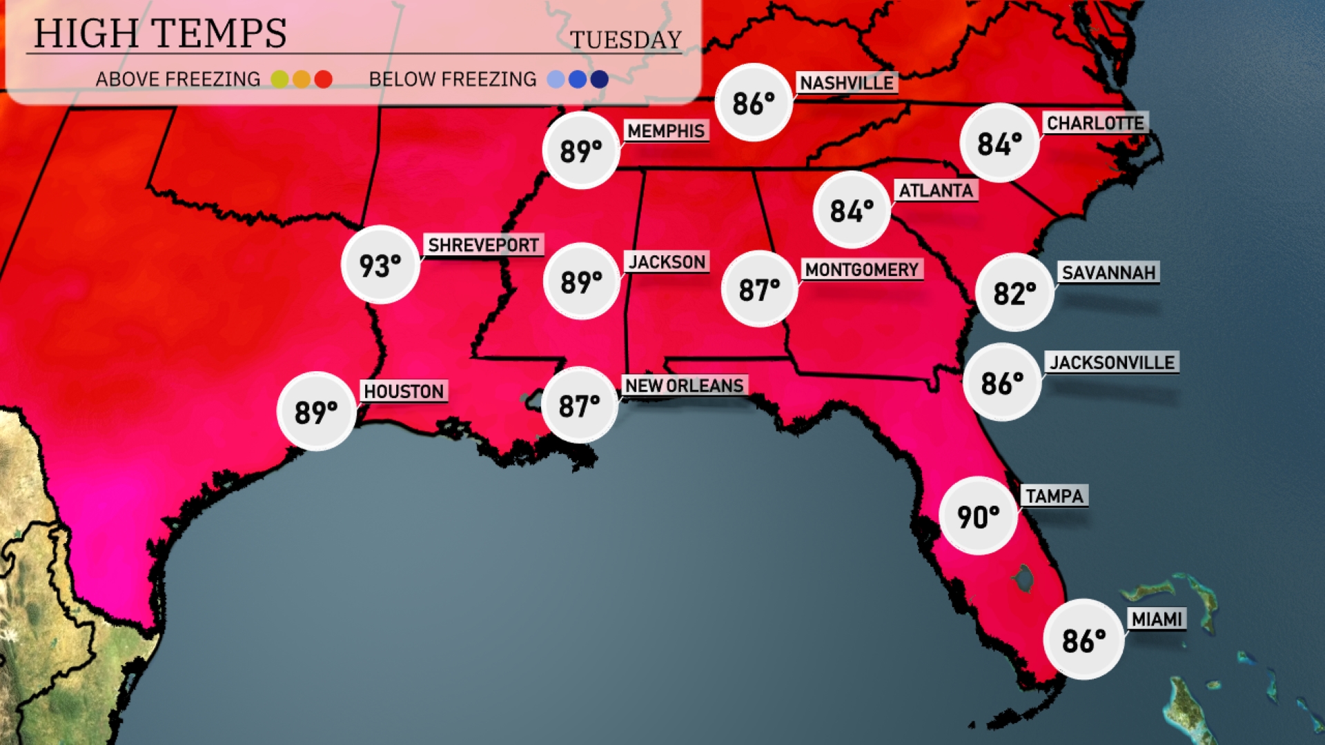
Today’s regional high temperatures are bringing a mix of warm weather across the Southeast. In Shreveport, expect a toasty high of 93 degrees, while Houston will be a bit cooler at 89. Moving east, Jackson is also warming up with a high of 89, and New Orleans is sitting at 87 degrees. In Florida, Tampa is heating up to 90 degrees, creating a distinct contrast as Miami cools down, peaking at just 86. Jacksonville will see a high of 86, making it a comfortable day in the Sunshine State.
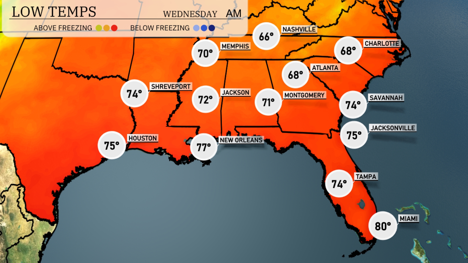
Tonight in Atlanta, expect a low of 68 degrees. Montgomery will cool down to 71, while Savannah will see a low of 74. Over in Shreveport, temperatures will drop to 74 as well. Temperatures remain warmer in New Orleans at 77 and Miami at 80, showcasing a mild night across the region.
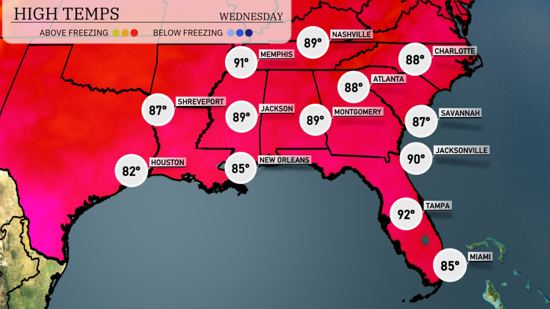
Tomorrow in the Southeast, highs will be sizzling with Jacksonville reaching 90 degrees. Tampa will be slightly warmer at 92 degrees, while New Orleans and Houston are expected to hit 85 and 82 degrees, respectively. Atlanta will see a high of 88 degrees, with Montgomery following closely at 89 degrees. Memphis is anticipating a warm 91 degrees and Jackson will also reach 89 degrees.
An active weather pattern unfolds across the Southeast tomorrow. Expect rain showers and thunderstorms from Atlanta to New Orleans, with heavy rainfall likely causing slick roads and localized flooding. The cold front pushing through will intensify storms, particularly from Mobile to Savannah, with a slight risk for severe storms on Wednesday. Temperatures will drop approximately 5 to 10 degrees after the front clears the area. Ultimately, drier conditions will prevail by the end of the week, promoting clearer skies into the weekend.
The UV index for Miami on Tuesday is an extreme 11 with a burn time of only 11 minutes, so please ensure you have maximum sun protection when going outside. On Wednesday, expect the index to decrease to a very high 8, with a burn time of 17 minutes.