Chicago Evening Breeze: A Guide to This Week’s Kaleidoscope of Weather
By
Amy Freeze
From balmy evenings to storm-laden skies, catch all your Midwest weather updates right here. Stay informed on what these changes mean for your plans!
Experience the fluctuating weather of the Midwest from the warmth of 90 degrees to the chill of incoming storms. Our blog explores what these changes could mean for your week ahead.
This week in Chicago and across the Midwest, our weather takes us on a dynamic journey from mildly clear evenings to the anticipation of severe thunderstorms. We’ll break down the forecast from calm, clear skies to the warning signs of a storm, focusing on temperatures, storm timings, and safety precautions. Keep up to date with all the changes and what they could mean for your daily plans by diving into our detailed analysis.
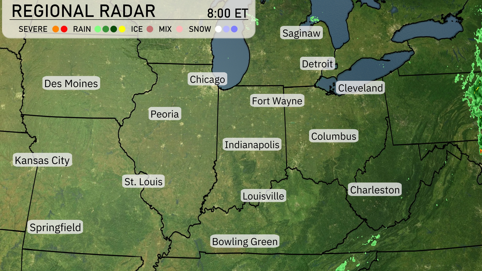
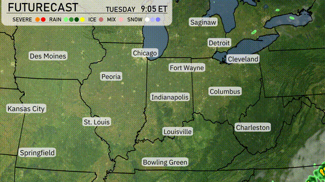
A band of showers and storms is sweeping across the Great Lakes region, stretching from Detroit down towards Cleveland, bringing moderate rainfall. The radar shows clear skies extending over much of the Midwest, particularly across Chicago, Indianapolis, and St. Louis, offering a break from any precipitation. Some residual light showers are visible moving away from the Springfield area. Keep an eye on isolated storm cells pushing into areas north of Bowling Green.
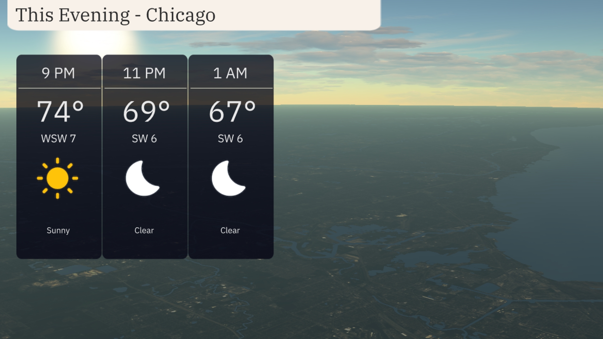
The evening in Chicago will be mostly clear and mild. Temperatures will start at 74 degrees at 9 PM and gradually decrease to 67 degrees by 1 AM. Winds will be around 6 to 7 miles per hour from the west-southwest, maintaining a light breeze.
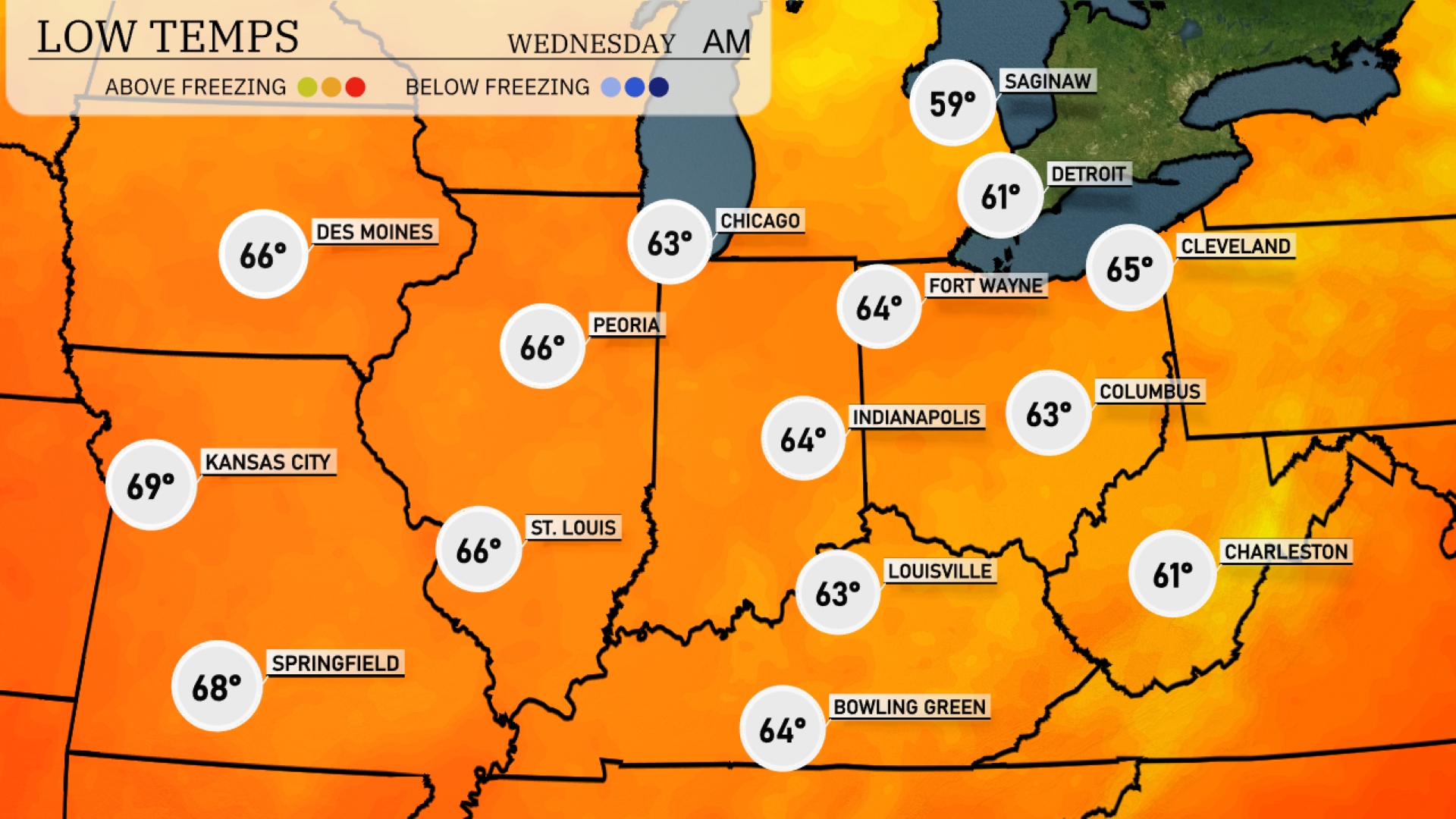
Tonight, Chicago will see a low of 63 degrees, while Indianapolis drops to 64. Fort Wayne will register at 64 degrees, with Louisville at 63. Expect Kansas City to cool down to a pleasant 69 degrees, while St. Louis will chill to 66 degrees.
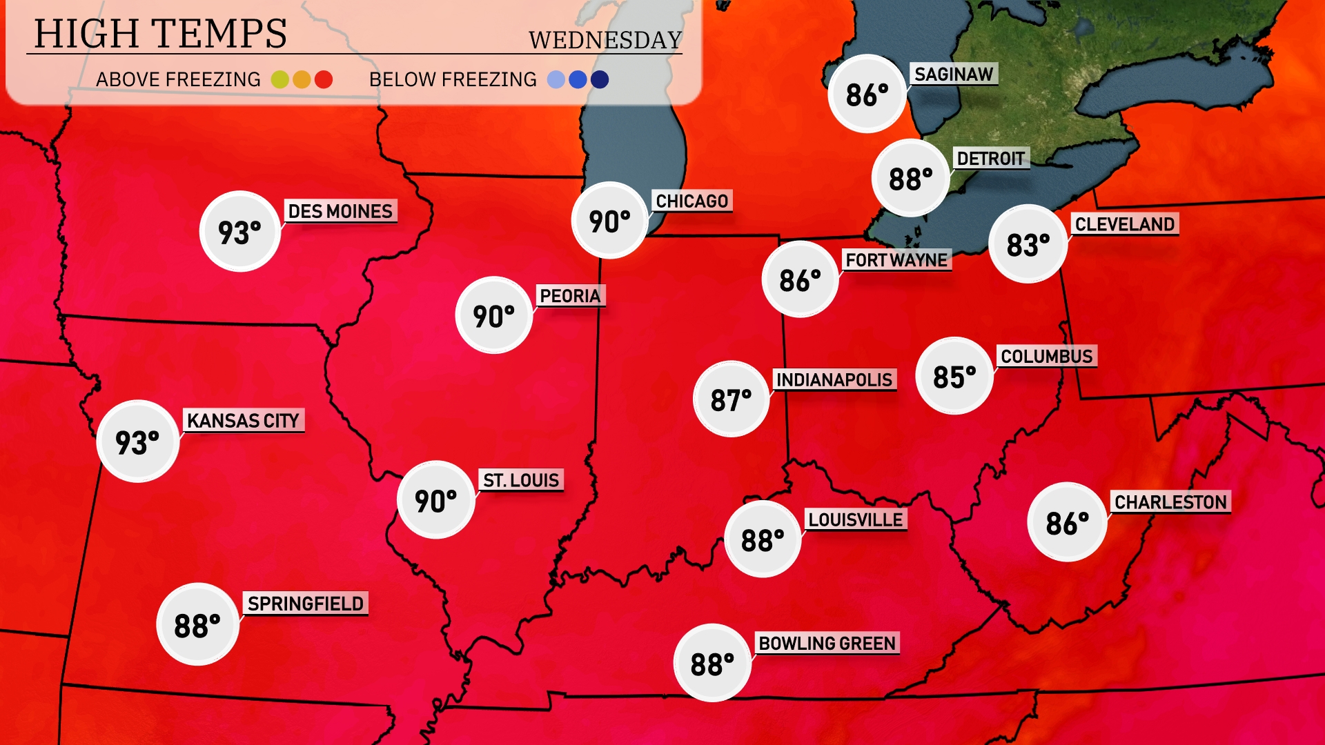
Tomorrow, temperatures will soar across the Midwest with Kansas City and Des Moines both hitting a steamy 93 degrees. Chicago and Peoria are expected to warm up to 90 degrees, while St. Louis is right on their heels at 90 as well. Indianapolis will see a high of 87 degrees, slightly below average, whereas Louisville and Bowling Green will reach 88 degrees.
A warm front ushers in rising temperatures across the Midwest, bringing a surge in humidity. Look for thunderstorms developing by afternoon from St. Louis to Chicago, with a risk of severe storms featuring gusty winds and large hail. Heavy rain may lead to localized flooding, especially in low-lying areas around Indianapolis and Columbus. By evening, cooler air follows this system, dropping temperatures significantly, and pushing the showers eastward towards Cleveland.
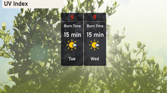
On Tuesday, the UV index in Chicago will be very high at 9, with a potential burn time in direct sunlight of about 15 minutes, so make sure to take extra precautions to protect your skin. Similarly, Wednesday’s UV index remains at 9, maintaining the quick burn risk.
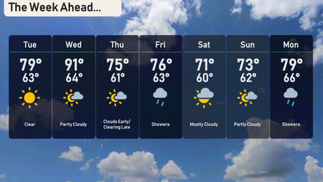
Tuesday: Clear skies with a high of 79 degrees and a low of 63 degrees.
Wednesday: Warmer and partly cloudy, reaching a high of 91 degrees and a low of 64.
Thursday: Clouds early, then clearing late. Expect a high of 75 degrees and a low of 61.
Friday: Showers throughout the day with a high of 76 degrees and a low of 63.
Saturday: Mostly cloudy conditions with the high reaching 71 degrees and a low of 60.
Sunday: Partly cloudy skies as temperatures rise to 73 degrees, with a low of 62.
Monday: Showers return, with a high touching 79 degrees and a low of 66.