Weathering Austin: A Tale of Sun, Rain, and Temperatures on the Rise
By
Amy Freeze
From impending thunderstorms to glorious sunny days, discover how Austin's weather will shape up this week. Prepare for dynamic weather changes and plan your activities with our detailed forecasts!
This week in Austin, brace for a diverse weather pattern. From intense thunderstorms to high UV index sunny days, we’ve got your full update. Stay prepared!
As Austin faces a week filled with varied weather patterns, residents can expect everything from heavy thunderstorms to sunny days with high UV indexes. Wednesday starts with thunderstorms, followed by clearing skies towards the weekend. Temperature variabilities present a need for a versatile wardrobe, especially with highs peaking at 95 degrees by Tuesday. Get our full, day-by-day breakdown and expert tips on how to navigate this unpredictable weather.
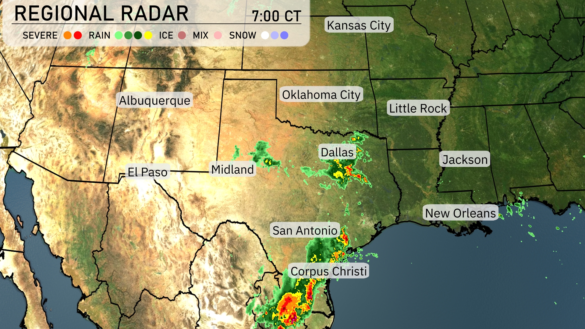
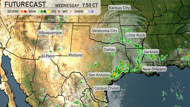
Across the Southern Plains, heavy rain showers are concentrated along the Texas coast, particularly impacting areas around Corpus Christi and San Antonio. The system of showers is moving northward, bringing a threat of severe weather to parts of southern Texas. Farther north, the Dallas area is experiencing scattered showers with potential for isolated thunderstorms. The region around Midland remains relatively dry and clear, while areas near Oklahoma City and Little Rock are enjoying calm, stable conditions.
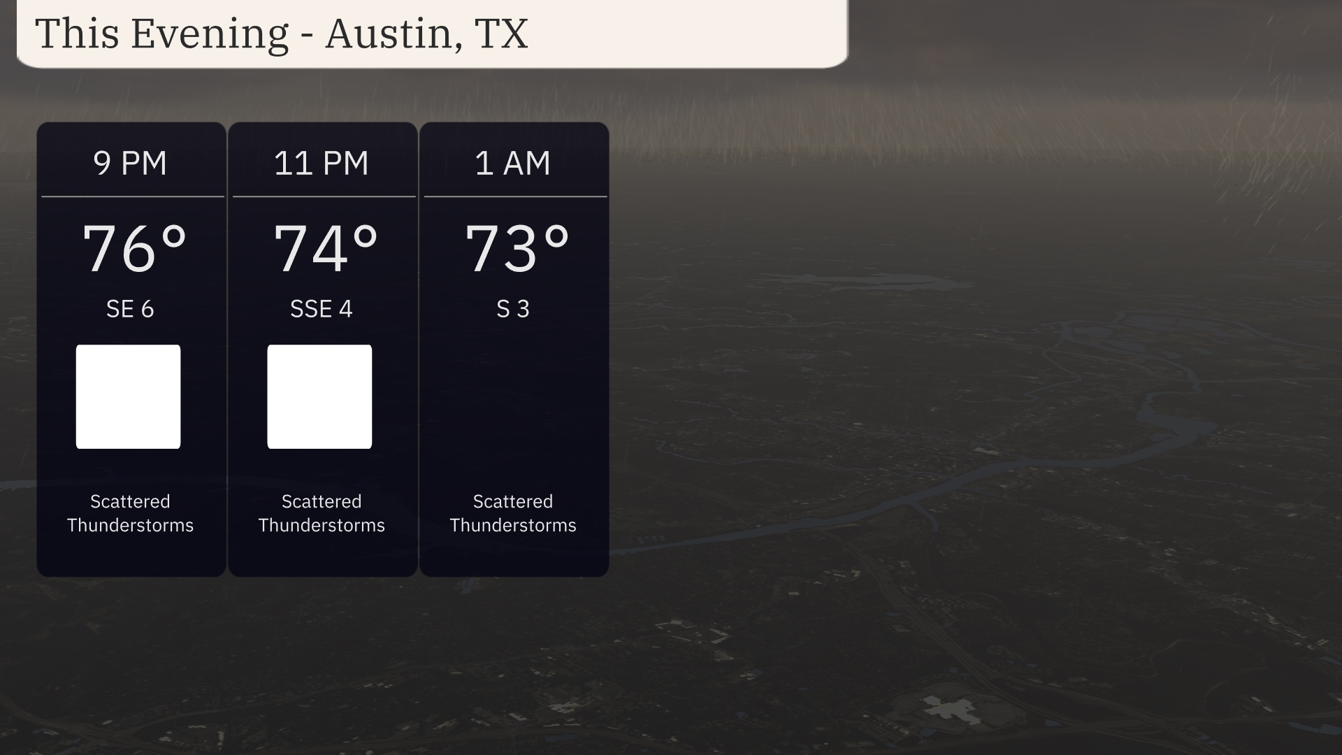
Temperatures this evening in Austin will start at 76 degrees at 9 PM, gradually cooling to 74 degrees by 11 PM, and reaching 73 degrees at 1 AM. Winds will be shifting slightly from southeast at 6 miles per hour to south-southeast at 4 miles per hour, then south at 3 miles per hour overnight.
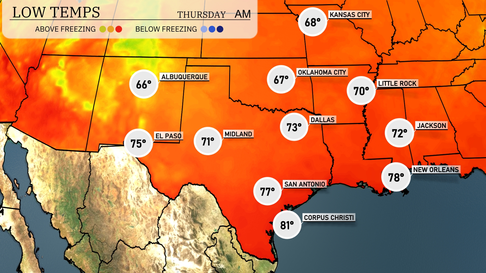
Tonight, Oklahoma City will see a low of 67 degrees. Dallas is expected to cool down to 73, with Little Rock dropping to 70. In Texas, San Antonio will experience a comfortable 77 degrees, while Midland will rest at 71. Expect slightly warmer conditions along the Gulf Coast, with New Orleans forecasted to stay around 78 degrees.
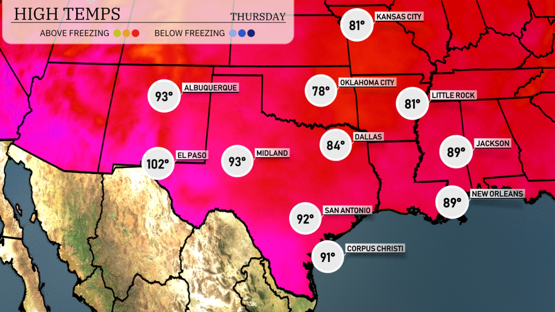
Tomorrow in El Paso, expect a scorching high of 102 degrees, while Midland will be slightly cooler at 93. San Antonio will see a warm up to 92 degrees, and Corpus Christi will reach 91 degrees. Dallas is forecasted for a high of 84 degrees, while Oklahoma City hits 78.
Looking ahead on the futurecast for the Southern Plains, expect a dynamic weather day. Starting with rain from Dallas to Corpus Christi, bringing much-needed moisture. Oklahoma City could see stronger storms with an unstable air mass as an approaching cold front rolls through. Be on the alert for severe weather in the southeast through Wednesday night, with potential heavy rainfall and damaging winds. New Orleans to Little Rock may experience a line of storms that could impact travel and outdoor plans.
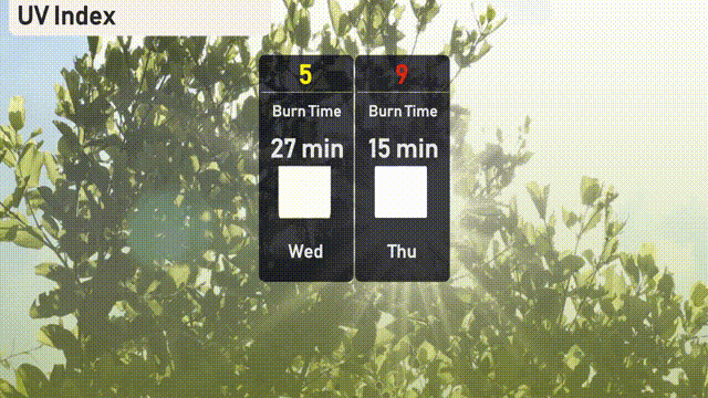
Get ready for a sunny Wednesday in Austin with a UV index of 5, giving a burn time around 27 minutes. By Thursday, the intensity ramps up to a UV index of 9, so be cautious with a burn time near 15 minutes.
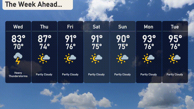
For the 7-day forecast in Austin:
Wednesday: Expect heavy thunderstorms with a high of 83 degrees and a low of 70 degrees.
Thursday: Partly cloudy skies return with a high of 87 degrees and a low of 74 degrees.
Friday: The temperatures rise, reaching a high of 91 degrees with a low around 75 degrees under partly clouded skies.
Saturday: Another warm day with partly cloudy conditions and a high of 91 degrees; the nighttime low will be 75 degrees.
Sunday: Partly cloudy, maintaining a high of 90 degrees and a low of 75 degrees.
Monday: Warming slightly to a high of 93 degrees, staying partly cloudy with an overnight low of 76 degrees.
Tuesday: The week ends with partly cloudy skies and a high of 95 degrees, cooling to 76 degrees at night.