Austin Weather Whiplash: From Thunderstorms to Sunshine
By
Amy Freeze
Get caught up with the latest weather trends sweeping through Austin and the Southern Plains, from stormy skies to clear, sunny days.
Tonight, the skies over Austin are clearing up, offering a respite from the earlier thunderstorms that dominated the Southern Plains. Catch a full week’s forecast and what these swift changes mean for you!
In Austin, we’re seeing a significant shift from heavy thunderstorms to clearer skylines. This evening, temperatures are cooling, making it a perfect time to enjoy the outdoors while being mindful of the ongoing severe weather alerts across the Southern Plains. From storm potential west of San Antonio to soaring highs in El Paso, we break down what you can expect weather-wise in the coming days. Join us as we explore these dynamic changes, providing you with all the insights you need to stay prepared.
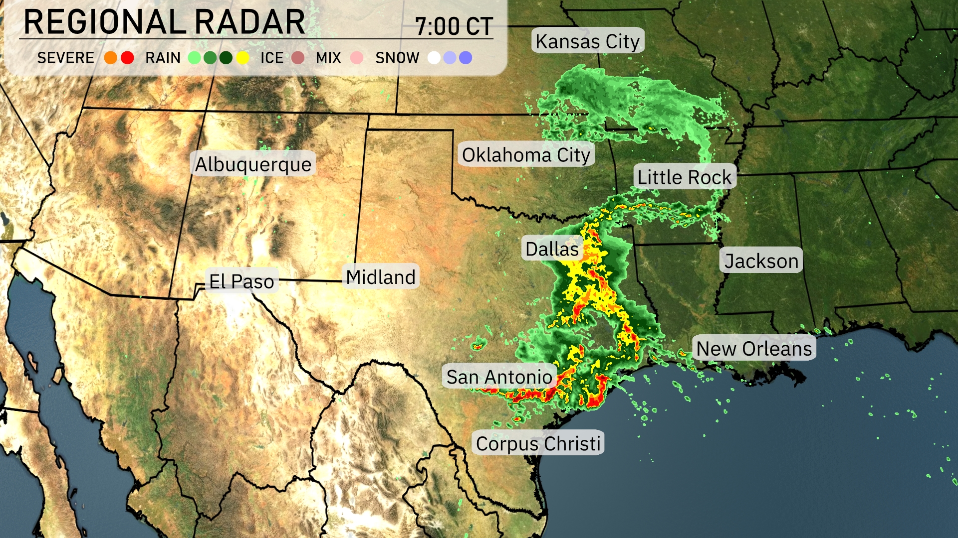
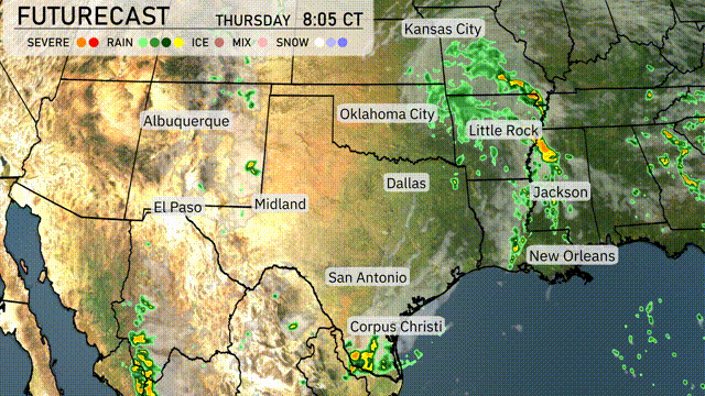
Thunderstorms are sweeping through the southern part of the Southern Plains, stretching from Dallas down to Corpus Christi. West of San Antonio, the storms intensify, showcasing severe weather potential. As we move north, rain showers extend from Oklahoma City toward Kansas City, with Little Rock experiencing some rain bands. The eastern region near Jackson is beginning to see rain developing, hinting at a wet day ahead for those areas.
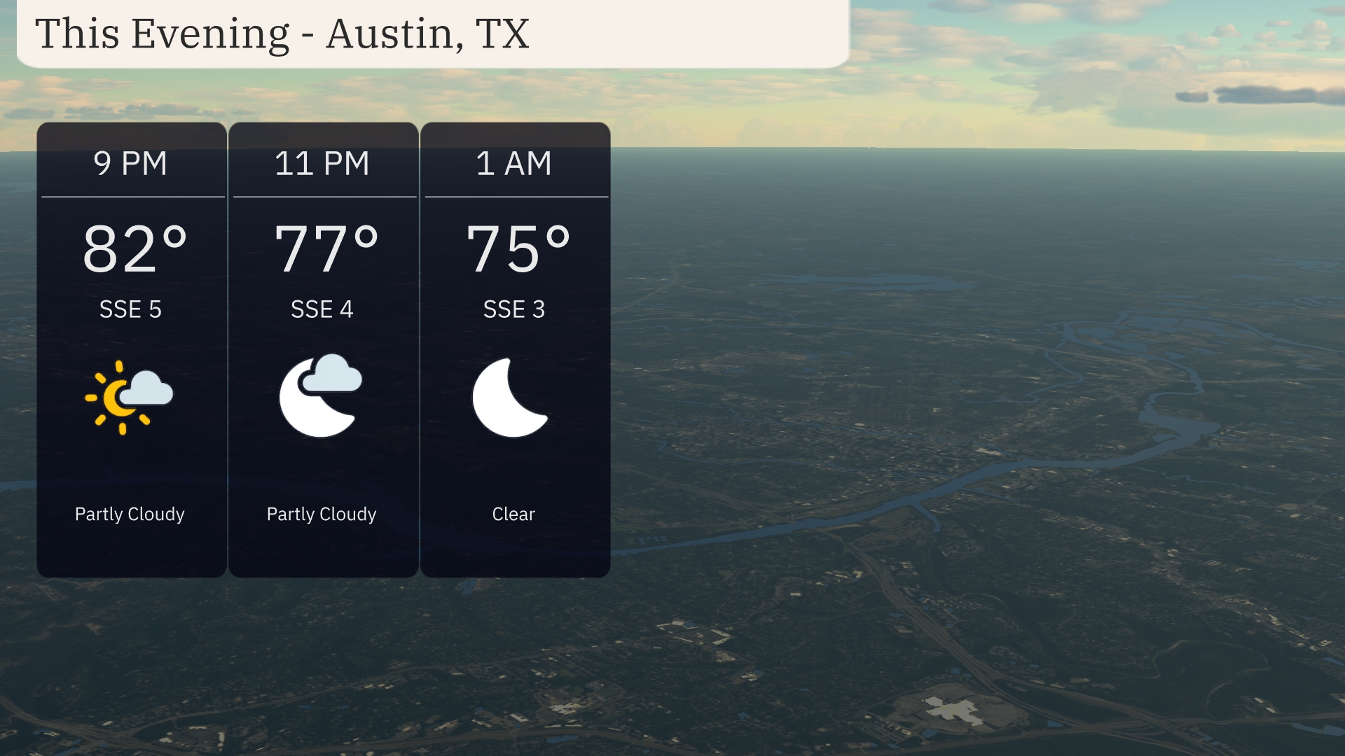
This evening in Austin, temperatures will drift from 82 degrees at 9 PM to 75 degrees by 1 AM. Expect partly cloudy skies early on, transitioning to clear conditions as the night progresses. Winds will remain gentle, shifting slightly from south-southeast at 5 mph down to 3 mph.
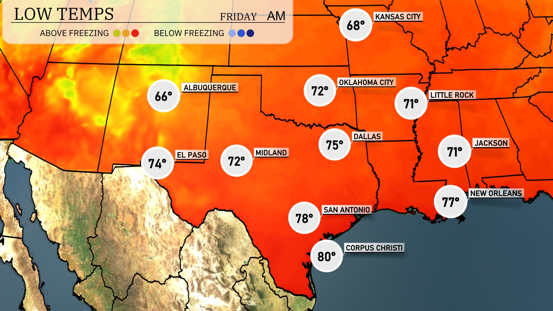
Tonight in the Southern Plains, temperatures will vary significantly. Dallas is forecasted to drop to 75 degrees, while Little Rock will reach a low of 71. Expect 71 degrees in Jackson and 78 in San Antonio, with a milder night in Corpus Christi at 80 degrees.
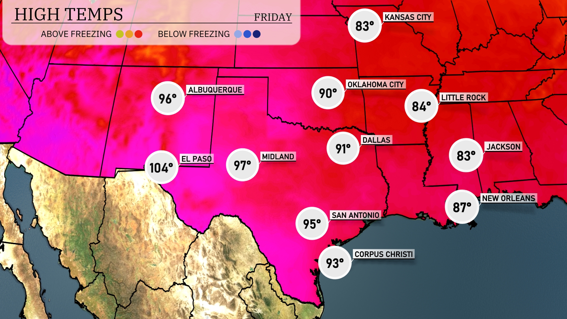
Tomorrow in El Paso, expect a scorching high of 104 degrees, which is well above average for this time of year. Midland will see a warm afternoon, reaching 97 degrees, while San Antonio will climb to 95. Dallas is forecasted for a high of 91 degrees, slightly above normal. Meanwhile, Corpus Christi will hit 93 degrees, and New Orleans will warm up to 87.
A dynamic weather pattern is unfolding over the Southern Plains tomorrow. Expect rain showers from Dallas to Corpus Christi, which will bring much-needed moisture to the region. Oklahoma City is under the possibility of stronger storms, so stay alert for severe weather warnings. An unstable air mass combined with an approaching cold front will heighten the risk for severe weather across the southeast. By late Thursday, weather conditions should stabilize, gradually clearing into the weekend.
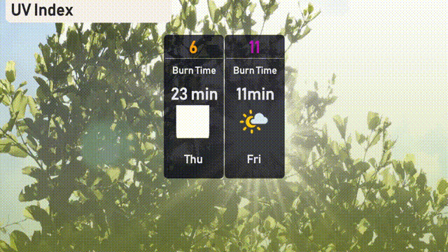
Today in Austin, the UV index will reach a high of 6 with a burn time of approximately 23 minutes. Tomorrow, Friday, the UV index climbs to 11, making the sun’s rays extremely strong, with a rapid burn time of 11 minutes.
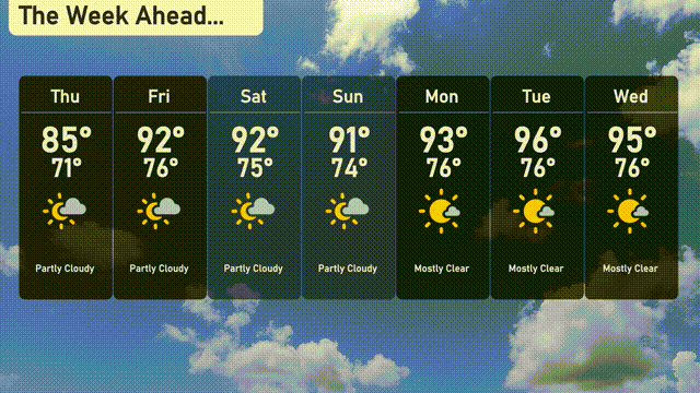
For the 7 day outlook in Austin:
Thursday: Expect partly cloudy skies with a high of 85 degrees and a low of 71 degrees.
Friday: The temperature climbs to a warm 92 degrees, with partly cloudy conditions and a low of 76 degrees.
Saturday: Another day of partly cloudy weather with a high of 92 degrees and the low holding at 75 degrees.
Sunday: Partly cloudy with temperatures peaking at 91 degrees during the day and cooling to 74 degrees at night.
Monday: Mostly clear skies with a high reaching 93 degrees and a low of 76 degrees.
Tuesday: Another mostly clear day with the afternoon high soaring to 96 degrees and a low of 76 degrees overnight.
Wednesday: The trend continues with mostly clear conditions and temperatures sitting at a high of 95 degrees, with a nighttime low of 76 degrees.