Austin Weather Update: Clear Skies Today with a Stormy Week Ahead
By
Amy Freeze
Explore the swift changes in weather from today's clear skies to potential thunderstorms across the Southern Plains. Detailed forecast inside.
With clear skies today and temperatures peaking nicely, the brief calm in Austin will transition to a bustling week of fluctuating temperatures and potential storms. Learn what the weather has in store for your week!
In Austin, the atmosphere starts off serene with clear skies and gentle winds. By mid-morning, count on a temperature rise and a slight shift towards cloudier skies. Looking ahead, Austin will experience a mixed bag of weather conditions including high temperatures and potential thunderstorms as a cold front approaches, promising to shake things up with showers and possibly even severe weather warnings. The UV index also indicates varying levels of sun exposure risk over the coming days. Stay prepared and tuned into our updates as we track this dynamic weather pattern.
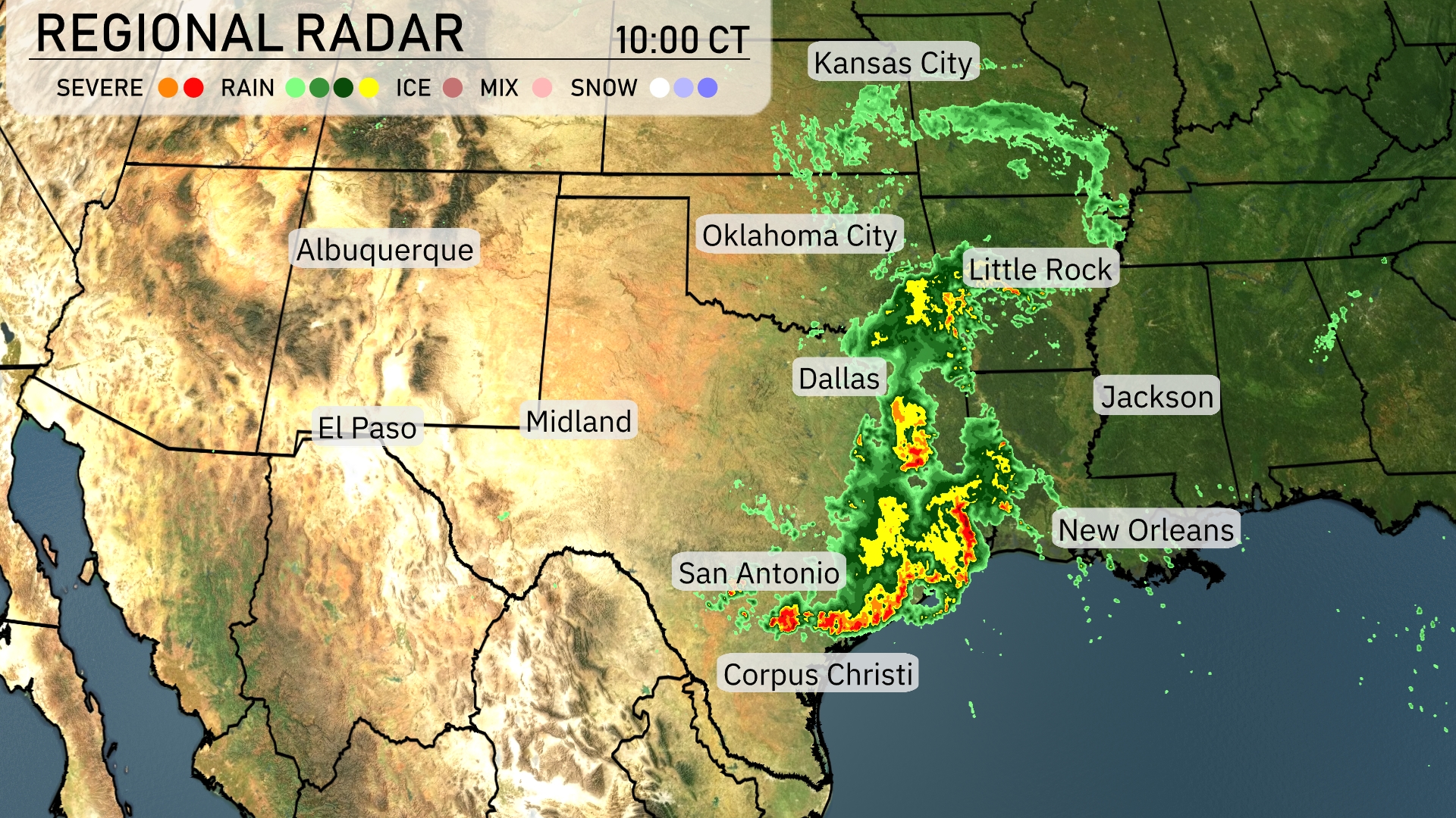
A line of strong storms stretches across Texas, extending from Corpus Christi up towards Dallas, pushing eastward with intense rainfall and potential severe weather. Little Rock might see some rain soon as this system advances. Oklahoma City is staying dry, but clouds are starting to build up. In contrast, Kansas City and the panhandle regions are enjoying clear skies, allowing for warmer temperatures.
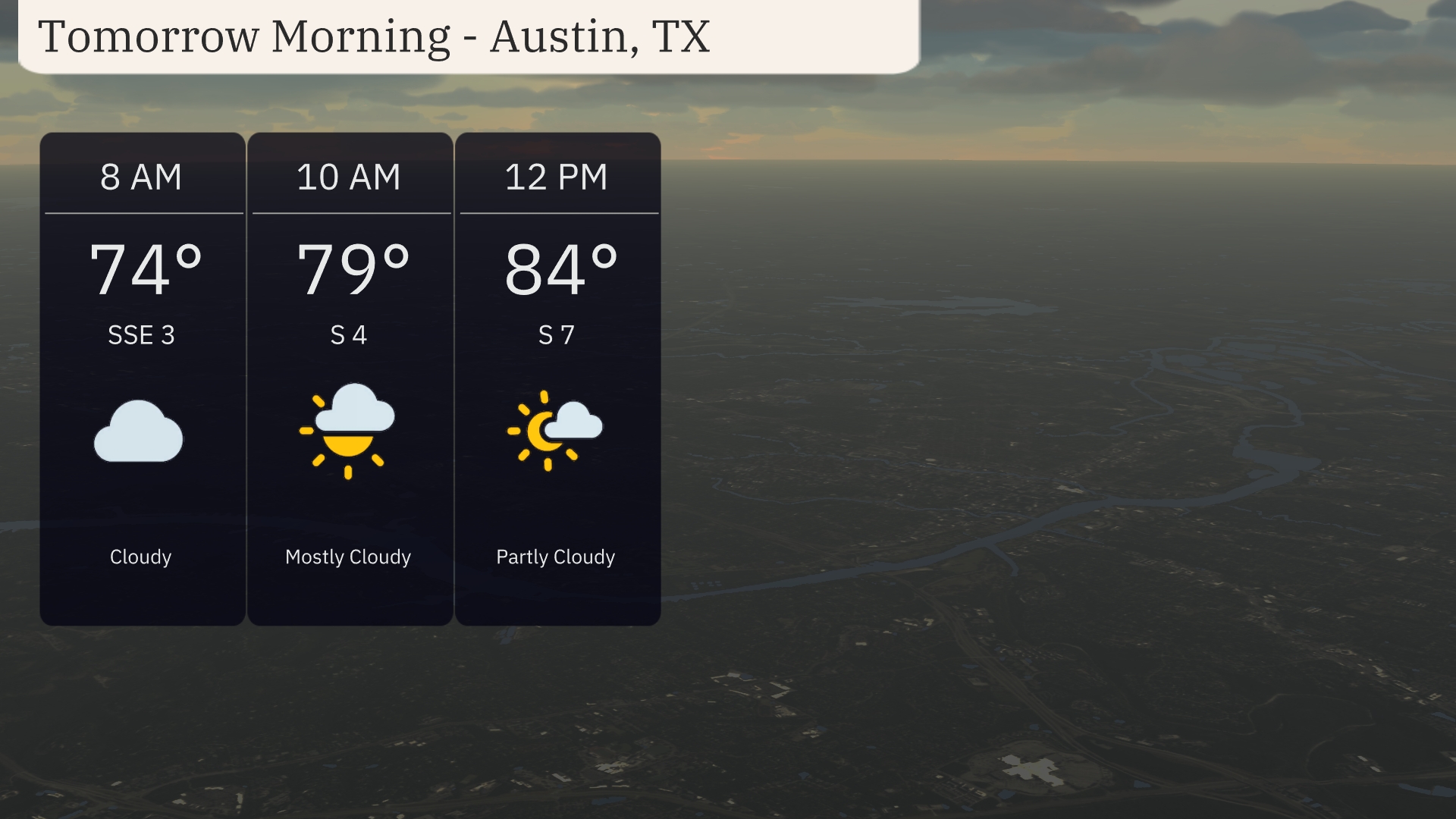
Tomorrow morning in Austin starts off cloudy at 8 AM with temperatures around 74 degrees and a gentle south-southeast wind at 3 miles per hour. By 10 AM, expect temperatures to rise to 79 degrees as skies turn mostly cloudy, with south winds increasing to 4 miles per hour. As the morning progresses towards noon, partly cloudy skies will emerge, warming up to 84 degrees with a south wind at 7 miles per hour.
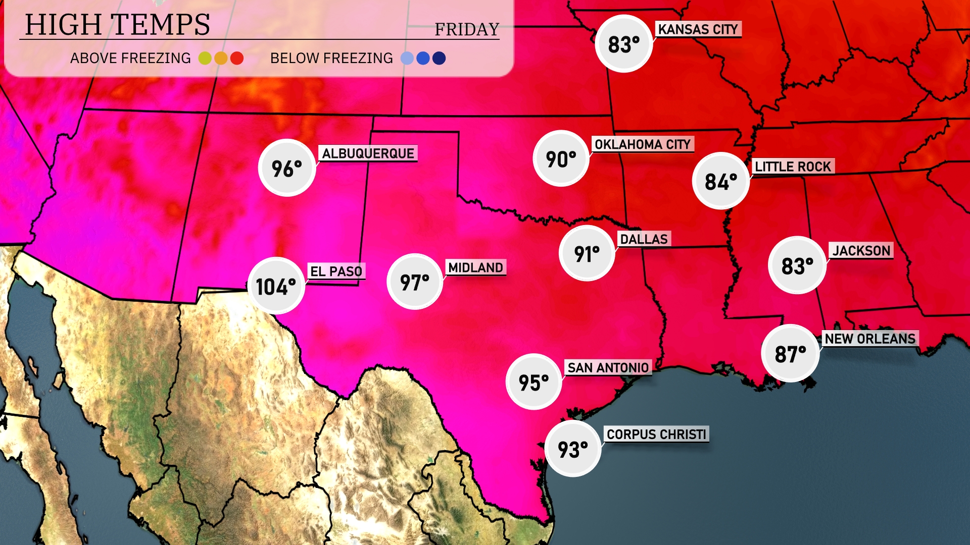
Tomorrow, El Paso will see exceptionally high temperatures reaching 104 degrees. Midland is expected to follow closely with a high of 97 degrees. San Antonio will warm up to 95 degrees, while Corpus Christi reaches a comfortable 93 degrees. Dallas will experience a high of 91 degrees, with Oklahoma City not far behind at 90. Temperatures in Jackson and Little Rock will be milder, peaking at 83 and 84 degrees, respectively.
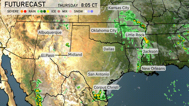
A cold front sweeping through the Southern Plains will bring notable weather changes, beginning with rain showers stretching from Dallas to Corpus Christi. Oklahoma City may experience stronger storms due to an unstable air mass. Look out for potential severe weather warnings as the front progresses southeastward, impacting areas through Wednesday night. Meanwhile, scattered thunderstorms are expected to develop over parts of Arkansas and Louisiana, increasing the risk of localized flooding. Temperatures are poised to drop following the passage of this front, bringing cooler and drier conditions into the weekend.
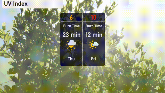
The UV index in Austin will be moderate today, holding at 6 with a potential burn time of about 23 minutes. On Friday, it steps up to a very high level of 10, sharply reducing the burn time to just 12 minutes.
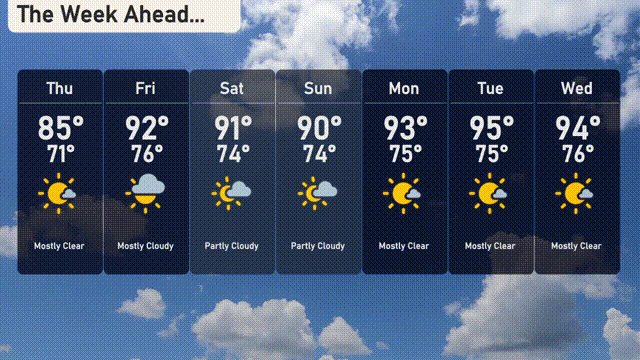
For the 7-Day Forecast in Austin:
Thursday: Mostly cloudy with a high of 85 degrees and a low of 71 degrees.
Friday: Watch for partly cloudy skies as temperatures rise to 92 degrees and dip to 76 degrees.
Saturday: A partly cloudy day with the high reaching 91 degrees and the low at 74 degrees.
Sunday: Expect partly cloudy conditions with temperatures peaking at 90 degrees and falling to 74 degrees overnight.
Monday: Mostly clear skies with a high of 93 degrees and a low of 75 degrees.
Tuesday: A day filled with sunshine, climbing up to 95 degrees, and a low of 75 degrees.
Wednesday: Another day of clear skies with a high of 94 degrees and a low of 76 degrees.