Navigating New York’s Nimbus: A Look at This Week’s Cloudy and Rainy Days
By
Amy Freeze
New York City experiences a mix of clouds and rain showers throughout the week. Get the detailed forecast from today till the sunny prospects of next Tuesday!
Prepare for a week of mixed skies in NYC! From rain showers to breaking clouds, know what to expect weather-wise in the Big Apple.
This week in New York City, weather patterns take us on a rollercoaster from cloudy skies with intermittent rain to sunny forecasts ahead. Temperatures fluctuate between mild to pleasantly warm, perfect for planning both indoor and outdoor activities. Detailed insights include temperature trends, precipitation expectations, and UV index updates across various NYC neighborhoods. Don’t let the weather surprises catch you off guard; stay informed and ready with our comprehensive weather analysis.
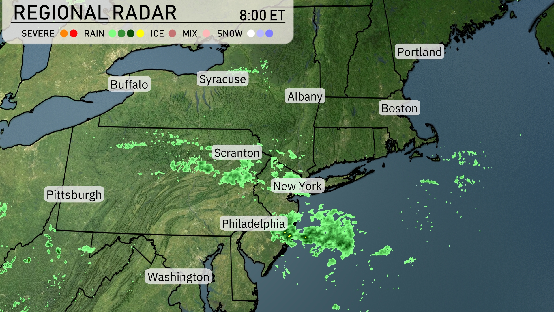
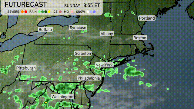
Cloudy skies are dominating the Northeast today with rain showers sweeping across areas from Philadelphia to New York City. Scranton is experiencing light to moderate rain as precipitation moves eastward. Upstate cities like Syracuse are seeing relatively clearer conditions, while some showers continue to dissipate. Boston and Portland remain outside the wet zone for now, enjoying a break from precipitation.
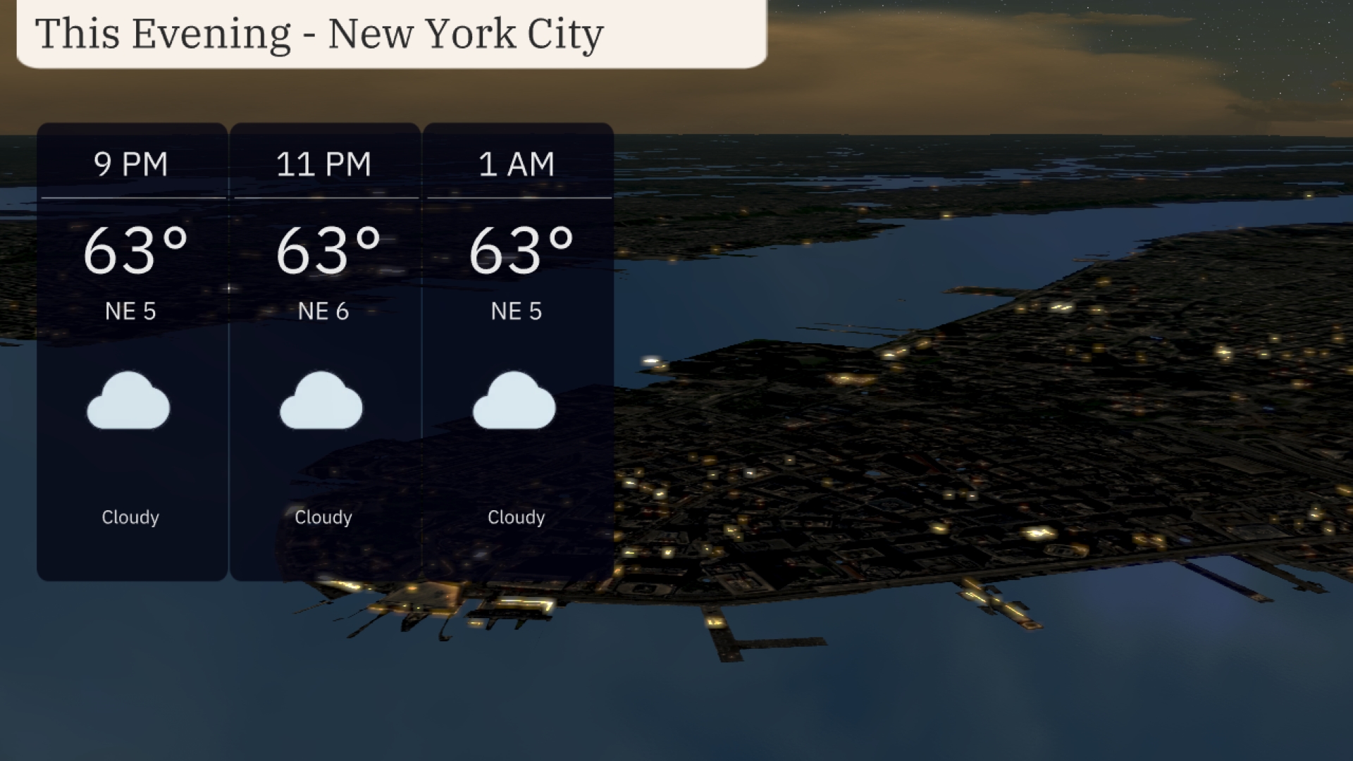
For this evening in New York City, temperatures are steady at 63 degrees throughout the night. Winds are from the northeast at 5 to 6 mph. Expect cloudy skies to persist into the early morning hours.
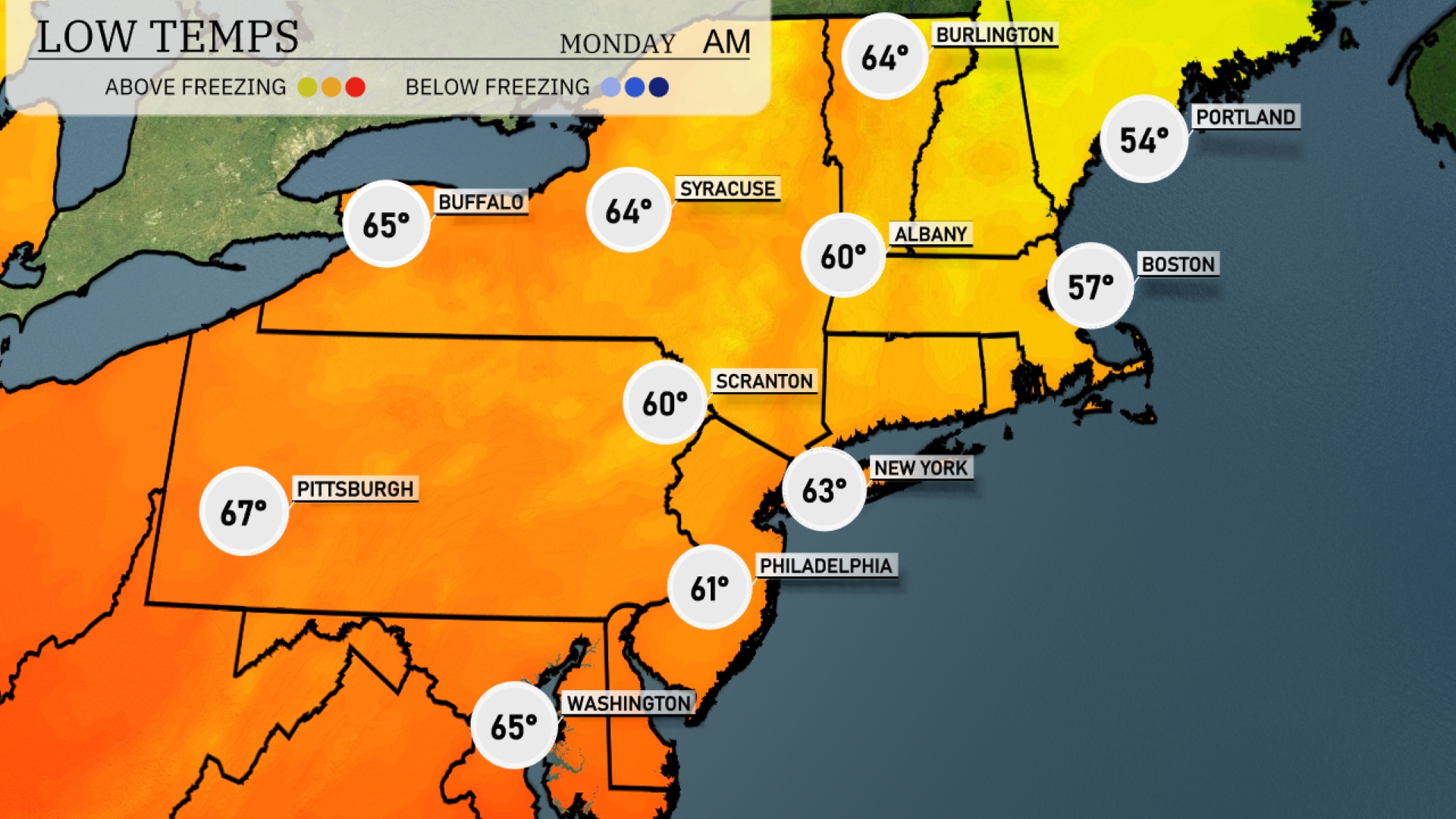
Tonight, low temperatures in the Northeast will reach 54 degrees in Portland. Boston will dip to 57, while New York is expected to experience a low of 63 degrees. Farther inland, Scranton will cool to 60 degrees, and Pittsburgh will stay a bit warmer at 67.
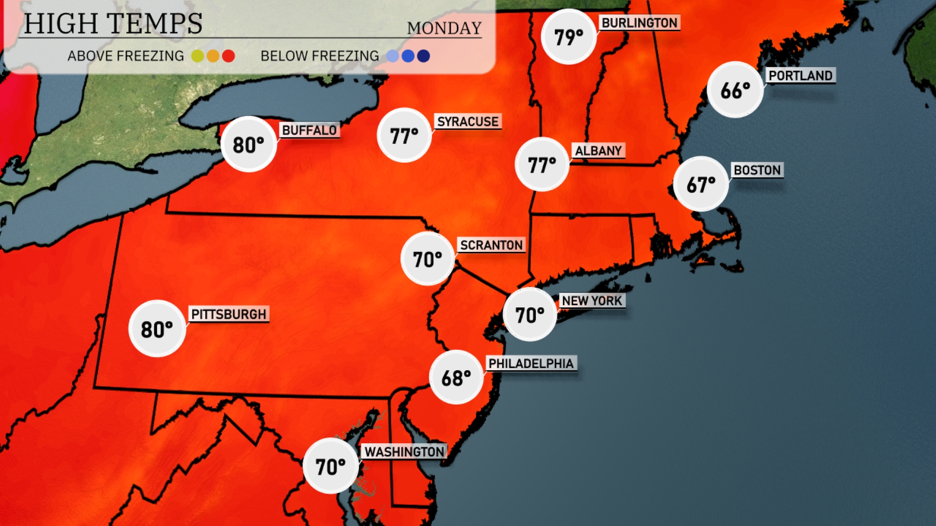
Tomorrow in the Northeast, expect temperatures to soar with highs reaching 80 degrees in Pittsburgh and Buffalo. Syracuse and Albany are looking at a pleasant 77 degrees, while Philadelphia will see temperatures around 68 degrees. New York City and Scranton are forecasted to hit 70 degrees, maintaining seasonal warmth. Boston remains cooler at 67 degrees, slightly below the average for this time of year, influenced by light cloud cover moving in from the northeast.
A weak storm system moves across the Northeastern U.S., bringing scattered showers, particularly in areas like New York City and Philadelphia. Expect cloudy skies with intermittent rain, potentially affecting your afternoon commute. Syracuse to Albany may see localized heavier rain, enhancing the risk for minor flooding in poor drainage areas. Cooling temperatures accompany this front, with highs ranging from the upper 60s to mid-70s. By late Monday, skies begin to clear, setting the stage for a sunny Tuesday.
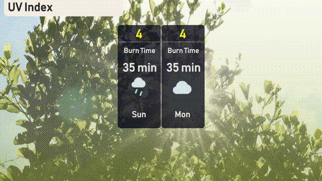
New York City has a UV index of 4 today and Monday, indicating moderate sun exposure with a burn time of about 35 minutes in direct sunlight. With rain in the forecast, UV impact may be reduced during showers.
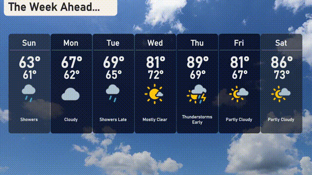
For the 7-day forecast in New York City:
Sunday: Showers throughout the day with a high of 63 degrees, cooling to 61 degrees overnight.
Monday: Cloudy skies ahead, the temperature will reach 67 degrees and dip to 62 degrees at night.
Tuesday: Expect showers later in the day with a high of 69 degrees and a low of 65 degrees.
Wednesday: Mostly clear skies with temperatures climbing to 81 degrees, dropping to 72 degrees after sunset.
Thursday: Thunderstorms are expected early, with temperatures peaking at 89 degrees and reducing to a low of 69 degrees.
Friday: Partly cloudy skies and a high of 81 degrees, cooling down to 67 degrees overnight.
Saturday: Partly cloudy conditions with a warm high of 86 degrees and a low of 73 degrees.