Chicago Weather Update: From Gentle Breezes to Thunderous Storms
By
Amy Freeze
Explore the swings in Chicago’s weather this week - from soothing breezes to sudden storms and bright, sunny days.
The weather in Chicago is taking a turn this week, with temperatures swinging and storms brewing. Make sure to stay updated with our forecasts as we track these changes!
Welcome to your in-depth look at Chicago’s weather for the upcoming week. We’re expecting everything from mild, partly cloudy days to potentially severe thunderstorms. Let’s break down what you can expect day-by-day so you’re never caught off-guard. Don’t forget to check back for updates as the week progresses, especially with potential storms on the horizon!
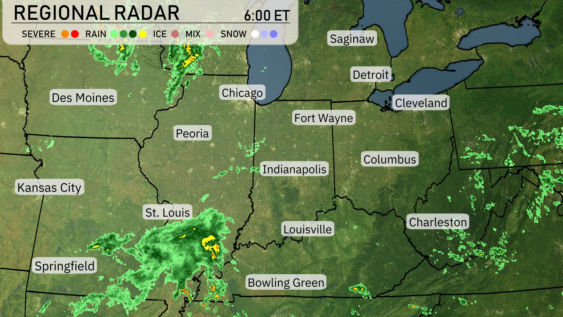
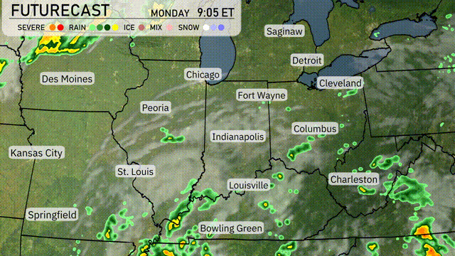
On the Regional Radar, we can see a band of rain moving across Eastern Illinois and toward Chicago, bringing showers to the city. St. Louis is experiencing moderate rain with more showers trailing southwest into Springfield. In the Northern Indiana area, rain is scattered around Fort Wayne, while lighter showers are approaching Indianapolis. Cleveland is seeing some cloud cover but remains dry for now.
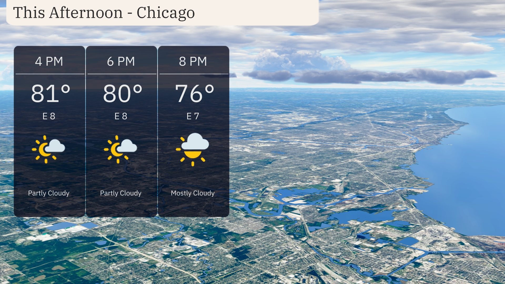
In Chicago this afternoon, temperatures hover around the low 80s, with a high of 81 degrees at 4 PM. Partly cloudy skies dominate with a light east wind at 8 miles per hour, providing a gentle breeze. By 8 PM, temperatures will dip to 76 degrees as cloud cover transitions to mostly cloudy.
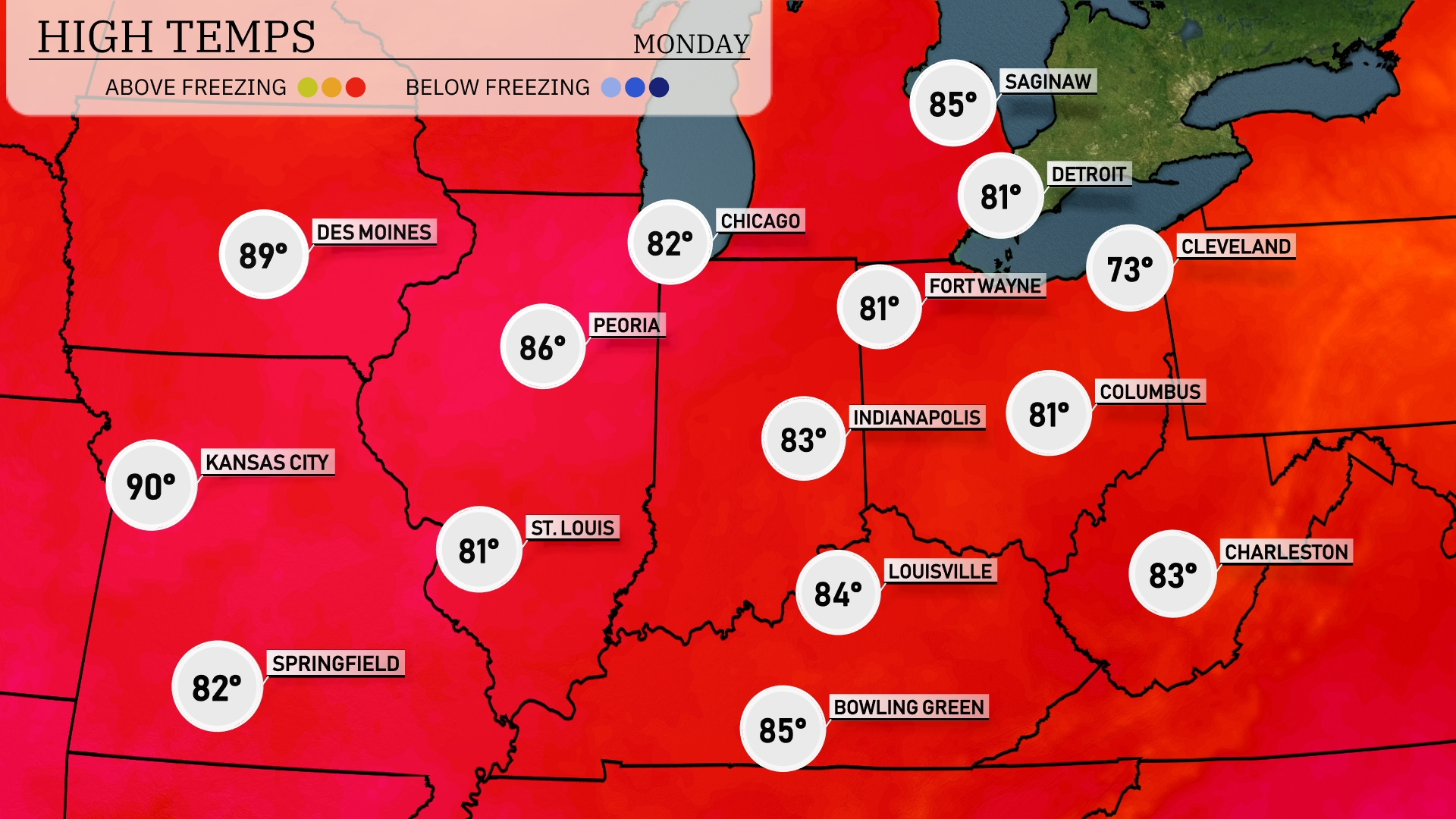
Today’s regional high temperatures in the Midwest are on the warm side. Kansas City leads with a high of 90 degrees, while St. Louis and Indianapolis enjoy more moderate temps at 81 degrees. Chicago will see a pleasant 82 degrees, with Peoria slightly warmer at 86. Cleveland is experiencing a cooler day with a high of just 73 degrees, offering a stark contrast to the warmer southern areas.
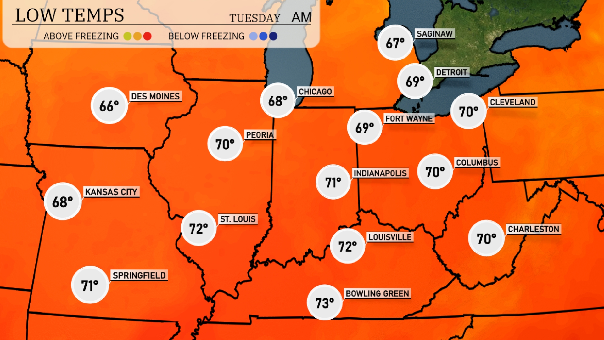
Tonight, Des Moines will dip to a mild 66 degrees, while Kansas City is expected to see a low of 68. In Chicago, temperatures will cool down to 68, and Indianapolis isn’t far behind at 71 degrees. Expect a similar trend in St. Louis with a low of 72.
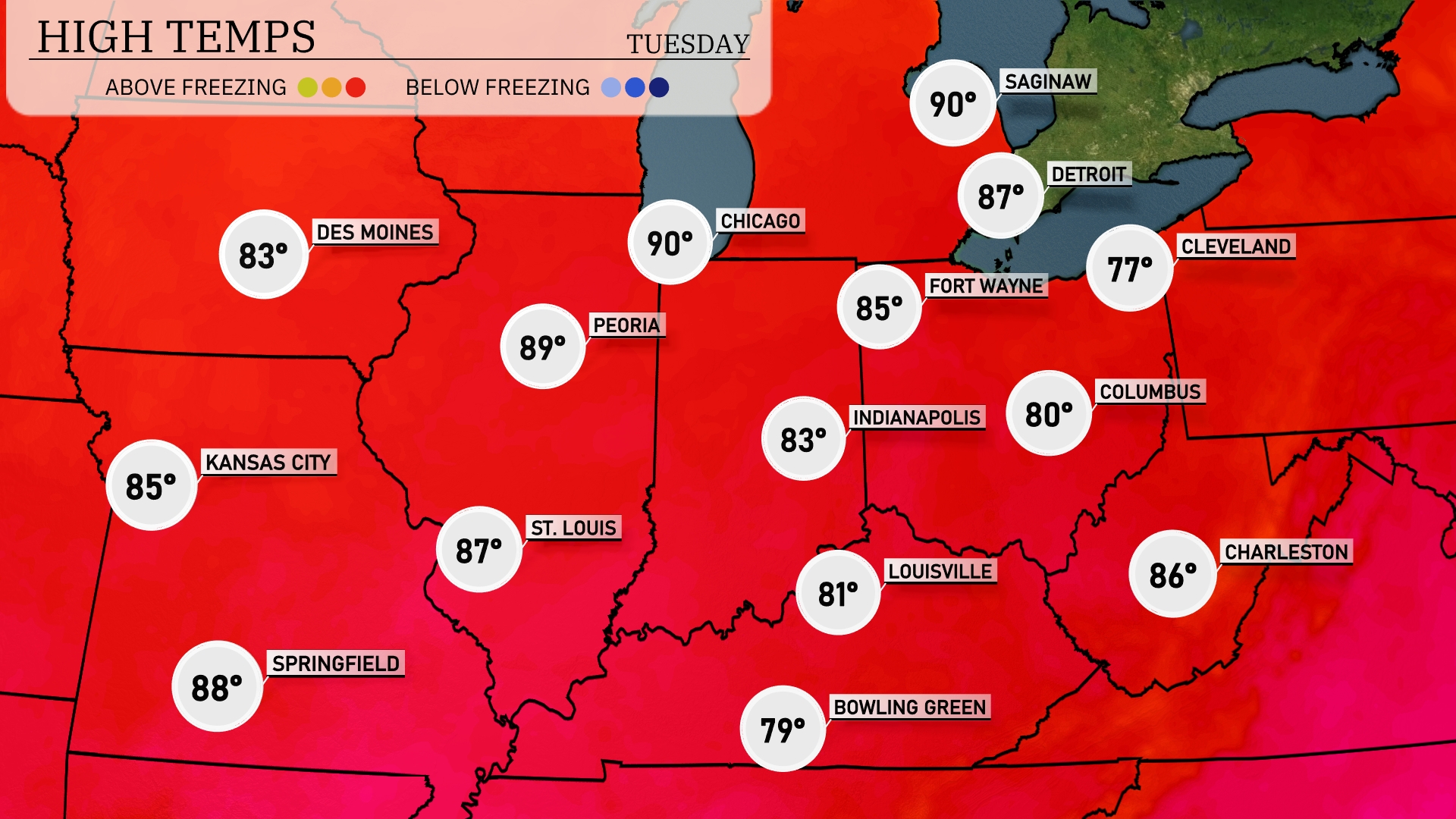
Tomorrow in the Midwest, Chicago will be sizzling with a high of 90 degrees, while nearby Fort Wayne reaches 85. Indianapolis will see a high of 83, and Columbus is forecasted to hit 80 degrees. Kansas City will enjoy a warm day at 85 degrees, and St. Louis is expected to peak at 87.
A weather system will bring showers and thunderstorms to parts of the Midwest, affecting cities from St. Louis to Cleveland through tomorrow. Expect scattered strong storms, particularly around Indianapolis and Columbus, with potential for localized flooding due to heavy rain. Temperatures will trend cooler behind this system, dropping about ten degrees from today’s highs. As the weather pattern shifts, look for clearing skies on Wednesday, with drier conditions extending into late week. Stay alert to updated forecasts in the event of severe thunderstorm warnings.
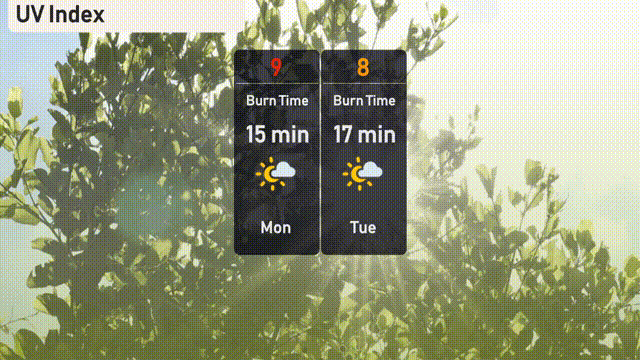
The UV index in Chicago on Monday will be very high at 9, with a burn time of just 15 minutes, so make sure to apply sunscreen and seek shade during peak hours. On Tuesday, the index slightly decreases to 8, still maintaining a quick burn time of 17 minutes! Stay safe and enjoy the sunny week ahead!