Navigating the Skies: Miami’s Week of Sun and Surprising Showers
By
Amy Freeze
Get the scoop on what’s brewing over Miami - your detailed weather forecast for a week filled with sun, sporadic showers, and unexpected stormy bends!
This week in Miami offers a mixed bag – sunny days with chances of unexpected showers and storms. Stay prepared with our detailed daily updates!
Welcome to your go-to source for Miami’s weekly weather forecast! From partly cloudy heavens to chances of afternoon showers and a potential stormy twist, here’s what your week looks like. Temperatures peak around 87°F with gentle breezes, perfect for enjoying the outdoors but stay vigilant – a cold front could bring thunderstorms. Don’t forget to check the UV index at 11, indicating high sun exposure risk. Dive into our daily breakdown to stay ahead of the weather game!
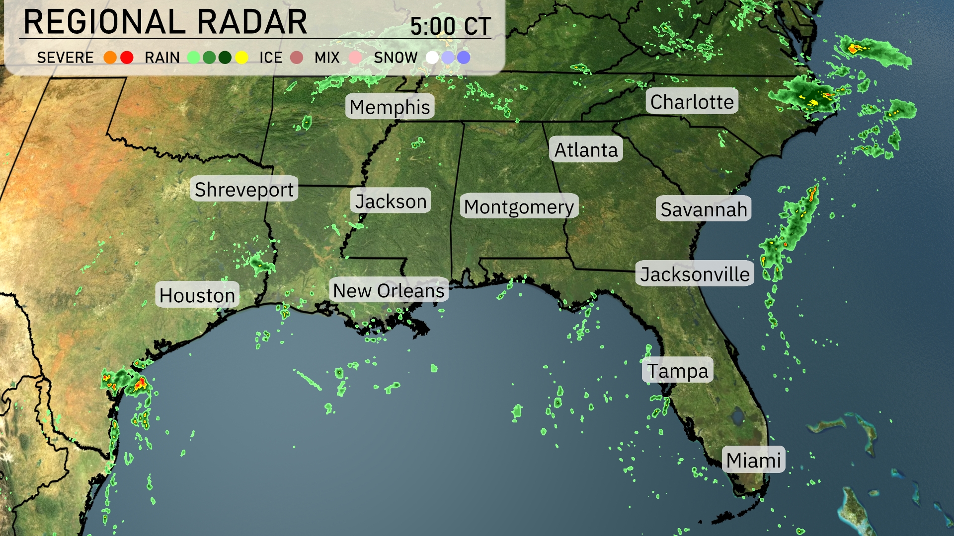
A cluster of storms is making its way eastward over New Orleans, progressing towards the Gulf Coast, while rain showers affect coastal areas just west of Tampa. Scattered showers are spotted across eastern Texas, notably near Houston, where light rain cells are drifting towards the east. Rainbands are reaching into the Carolinas with scattered showers near Charlotte, stretching down towards Savannah as cloud cover thickens. The areas around Atlanta, Memphis, and Jacksonville remain clear, enjoying dry conditions for now.
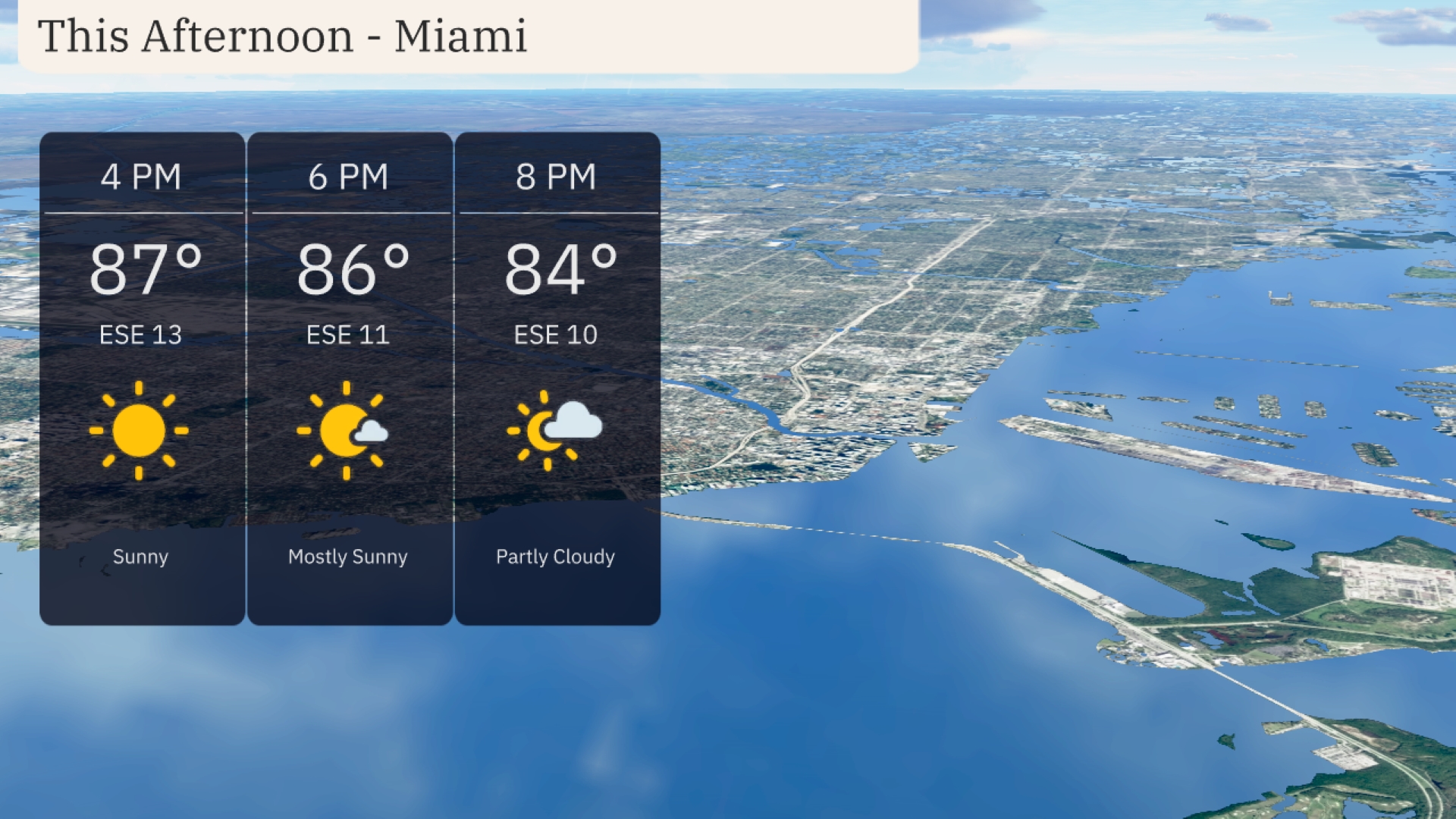
Afternoon temperatures in Miami will peak around 87 degrees at 4 PM, with sunny skies and a gentle east-southeast wind at 11 mph. By 6 PM, expect temperatures to dip slightly to 86 degrees, transitioning to mostly sunny conditions with winds remaining from the east-southeast at 11 mph. As evening approaches, temperatures will cool to 84 degrees at 8 PM under partly cloudy skies, with an east-southeast breeze at 10 mph.
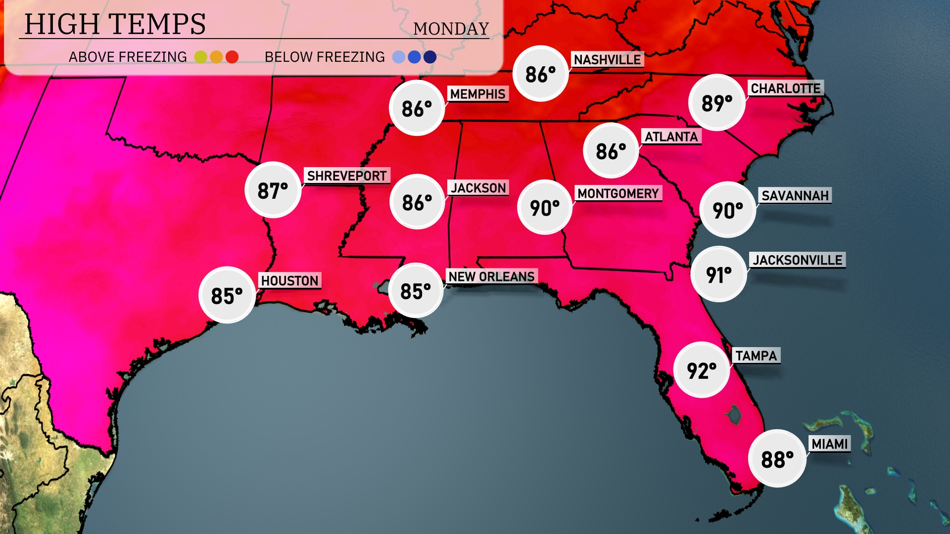
Today’s high temperatures across the Southeast show quite a range. In New Orleans, we’re looking at a warm high of 85 degrees, while Shreveport reaches up to 87. Montgomery will peak at 90 degrees, matching Jacksonville just below it at 91. Over in Tampa, expect even hotter conditions with a high of 92, while Miami offers a relatively cooler 88 degrees. It’s a day of sun and heat across the region, so stay hydrated!
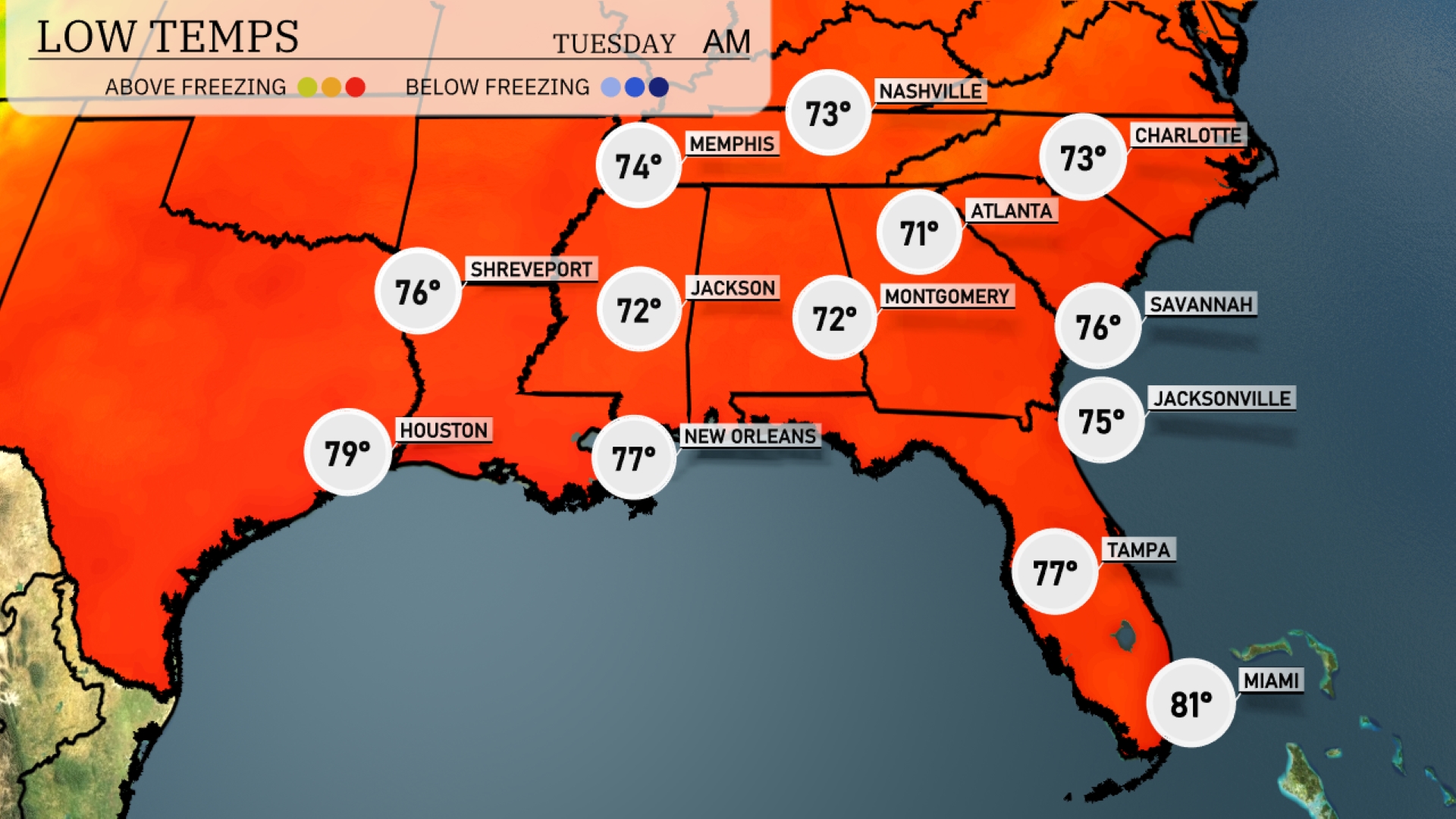
Tonight, temperatures will remain warm across the Southeast. Memphis will see a low of 74 degrees, while Nashville drops to 73. Expect lows of 72 in both Jackson and Montgomery. Atlanta will cool to 71 degrees, with Jacksonville at 75 and Tampa maintaining a mild low of 77. Miami rounds out the region with a warm 81 degrees overnight.
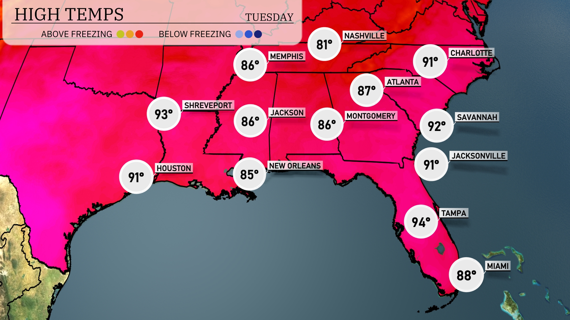
Tomorrow, the Southeast will experience notably warm temperatures. Atlanta is headed for a high of 87 degrees, while Nashville will see a peak of 81. In Florida, Tampa is set to hit a sizzling 94 degrees, with Jacksonville close behind at 91. Houston will also be warm, reaching 91 degrees, as Shreveport anticipates a high of 93.
A cold front is poised to move through the Southeast tomorrow, bringing scattered thunderstorms from Houston to Montgomery. Severe weather, including potential for isolated tornadoes, is most likely in parts of Louisiana and Mississippi during the afternoon. Expect heavy rainfall and gusty winds, especially in the New Orleans area. Into Tuesday, storms will push towards Atlanta and Charlotte by late evening.
The UV index in Miami is very high, at 11, both today and tomorrow. This means you’ll want to be careful, with a burn time of just 11 minutes in direct sunlight.