Chicago’s Weather Rollercoaster: From Sunny Days to Stormy Nights
By
Amy Freeze
Catch up on Chicago's dynamic weather patterns this week—from comforting mid-70s to stormy evenings, learn what the Midwest skies have in store for you.
This week, Chicago’s weather takes us on a dramatic journey from sunny days to stormy nights. Get the details with our latest forecast views.
Welcome to your detailed weather update for Chicago and the broader Midwest region. This week, you’ll experience everything from mild and sunny afternoons to potentially severe thunderstorms. Stay informed with our day-to-day forecast, including temperature variations, storm movements, and safety advice during unstable weather conditions. Keep this page bookmarked for continuous updates: https://amyfreeze.ai/
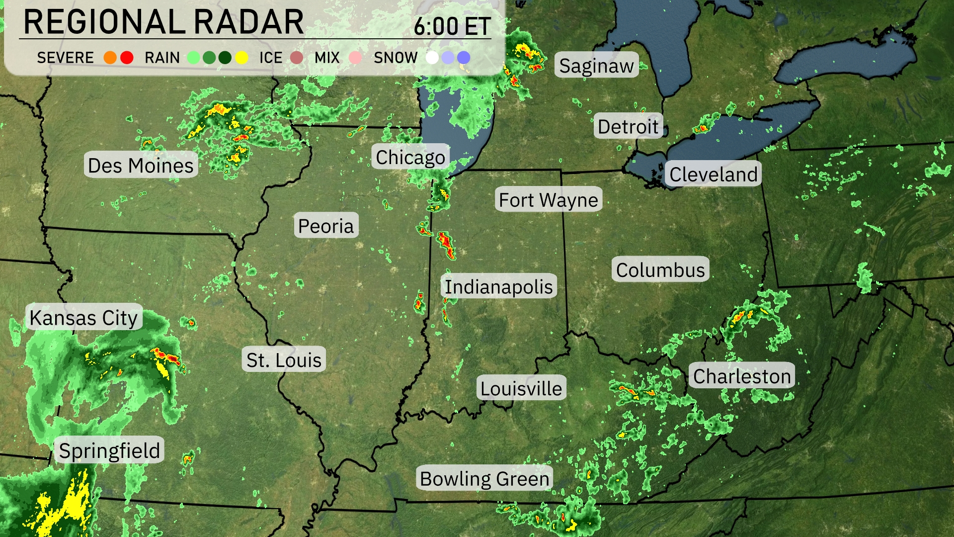
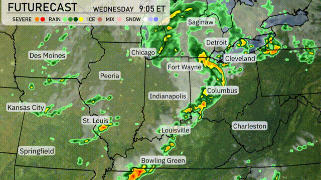
On the Regional Radar, a band of storms is making its way eastward, extending from Chicago down through Indianapolis. Heavy rain is seen just east of Bowling Green, moving into the Ohio Valley. Spotty rain showers are occurring near Peoria and Fort Wayne, with additional scattered showers developing around Kansas City and nearing Springfield. Areas such as Detroit and Cleveland are currently under cloud cover, experiencing calm weather conditions.
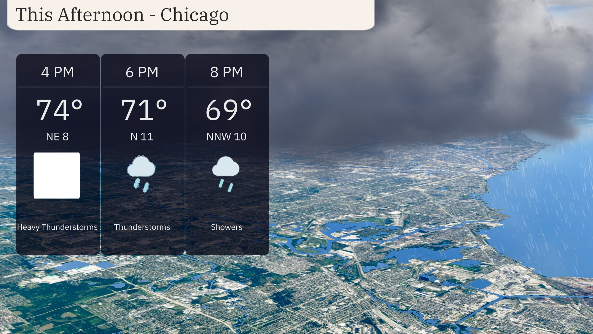
In Chicago this afternoon, temperatures hover in the mid-70s with northeast winds at 8 miles per hour. Heavy thunderstorms begin to roll in, transitioning to lighter but persistent thunderstorms by the early evening with temperatures dropping to 71 degrees. By 8 PM, expect additional showers as temperatures settle to 69 degrees, and winds shift slightly to NNW at 10 miles per hour.
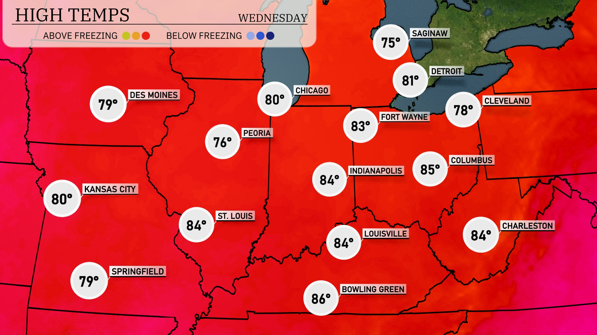
Today’s high temperatures in the Midwest are looking quite warm. Chicago is expecting a high of 80 degrees, while Kansas City and St. Louis are both reaching 80 and 84 degrees, respectively. Indianapolis will see a high of 84 degrees, and Louisville is slightly warmer at 86 degrees. Peoria is on the cooler end with a maximum of only 76 degrees. Fort Wayne and Columbus are in the mid-70s, with highs of 83 and 78 degrees, showcasing a nice variation across the region.
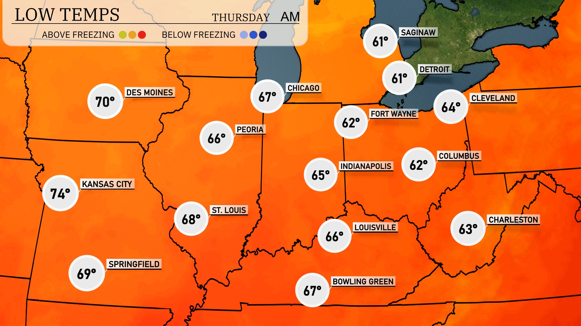
Tonight, Chicago will see a low of 67 degrees, while St. Louis cools down to 68. Indianapolis is expecting 65 degrees, and Louisville will drop to 66. Conversely, Peoria will see a low of 66, with Fort Wayne and Columbus dipping to 62 and 64 degrees, respectively.
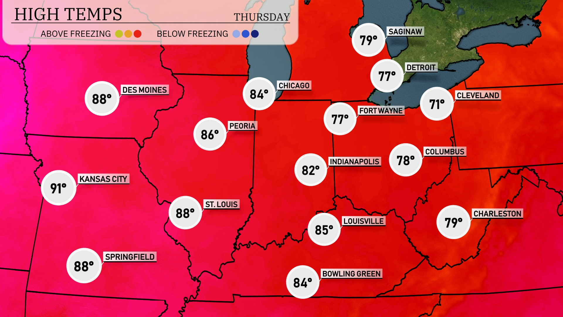
Tomorrow in the Midwest, Kansas City is set to hit a high of 91 degrees, while St. Louis and Springfield will both reach 88 degrees. Chicago expects temperatures around 84 degrees, and Indianapolis will see a high of 82. Peoria is forecasted for a warm 86 degrees, with Louisville closely following at 85.
Showers and thunderstorms will sweep across the Midwest early Wednesday morning as a cold front advances from St. Louis to Cleveland. Expect heavy rain and possible flash flooding, especially in low-lying areas; keep safety measures in mind. Temperatures will dip behind the front, bringing cooler air to cities like Chicago and Indianapolis by Wednesday night. Severe weather risks include pockets of damaging winds along the storm line heading east. As the front clears Bowling Green and Louisville, skies should begin to clear into Thursday, offering drier times ahead.
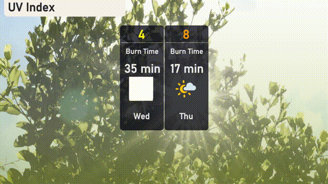
Expect a moderate UV index in Chicago on Wednesday with a value of 4, indicating a burn time of about 35 minutes in direct sunlight. On Thursday, the UV index will rise to 8, with a quicker burn time of 17 minutes.