From Sizzling Days to Stormy Nights: A Comprehensive NYC Weather Forecast
By
Amy Freeze
Explore our thorough breakdown of the weather patterns sweeping across New York City and the Northeast, with updates on potential storms and temperature shifts throughout the week.
Dive into the latest weather updates for NYC this week, from sun-filled days to potential stormy nights.
https://www.youtube.com/watch?v=jrdNm8eWk3I
In this week’s weather forecast, NYC experiences a dynamic shift from clear, sunny skies to a spell of thunderstorms driven by a cold front sweeping the Northeast. With temperatures peaking comfortably before plummeting, and a dramatic weather change anticipated, how should New Yorkers prepare for the week ahead? Visit our detailed guide at https://amyfreeze.ai/ for daily weather insights.
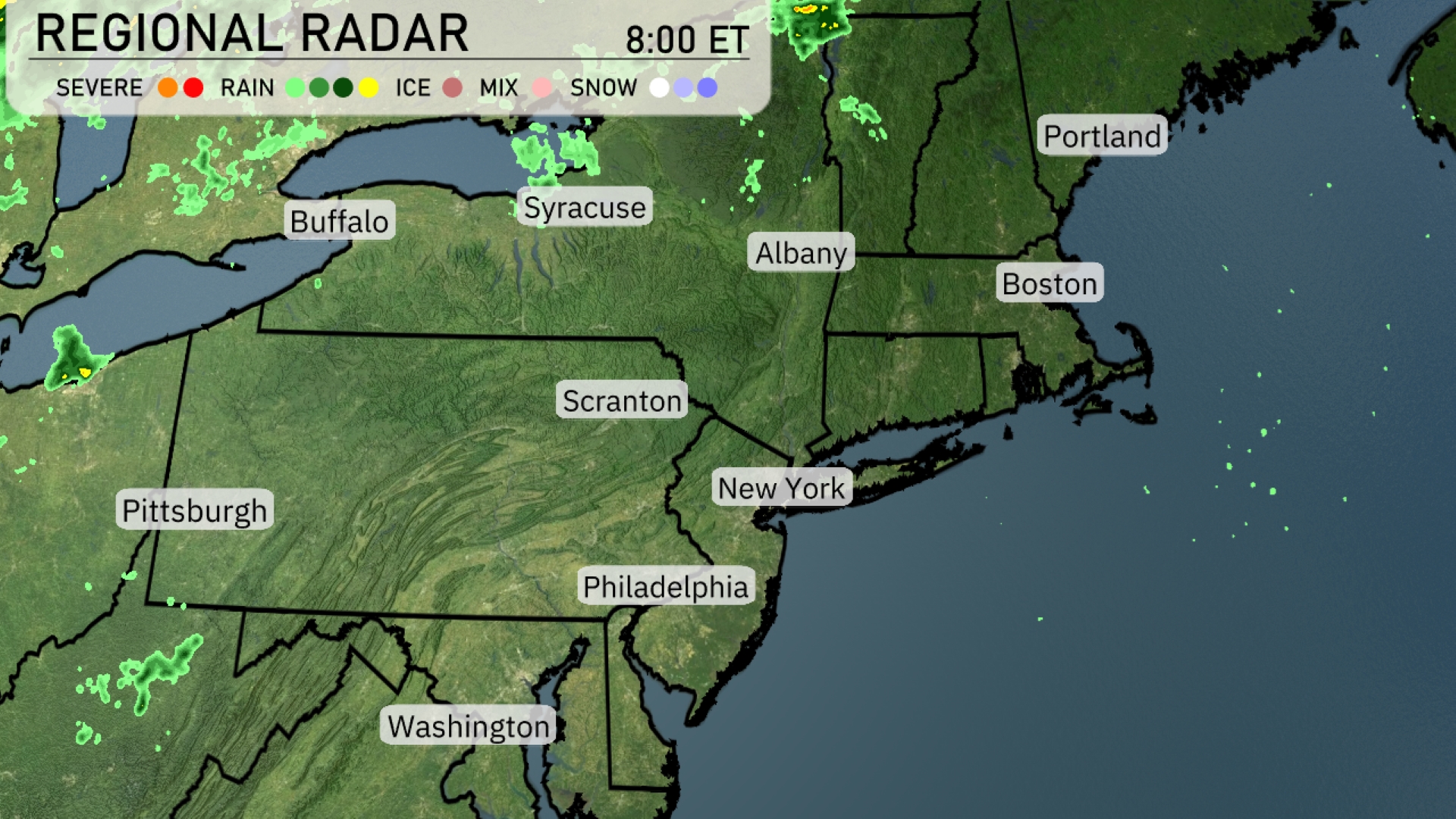
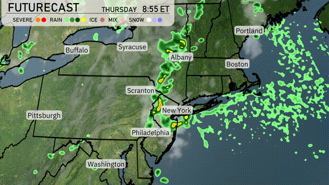
On this Regional Radar, the Northeast is mostly clear, with a few patches of light rain extending over Syracuse and eastwards towards Albany. Buffalo is seeing intermittent showers with drier conditions anticipated later. Scranton and Philadelphia remain dry with occasional cloud cover. Portland is not under any precipitation but could expect cloudiness throughout the day.
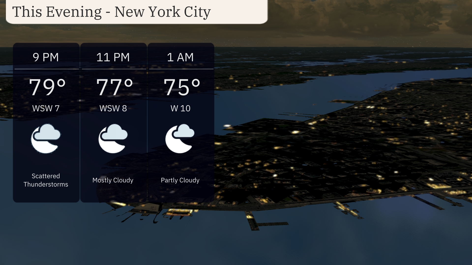
Temperatures in New York City this evening start at 79 degrees at 9 PM, dropping to 75 degrees by 1 AM. Wind conditions will range from a light WSW breeze at 7 mph to 10 mph later in the night. Expect scattered thunderstorms transitioning to mostly cloudy skies by 11 PM, with partly cloudy conditions settling in by 1 AM.
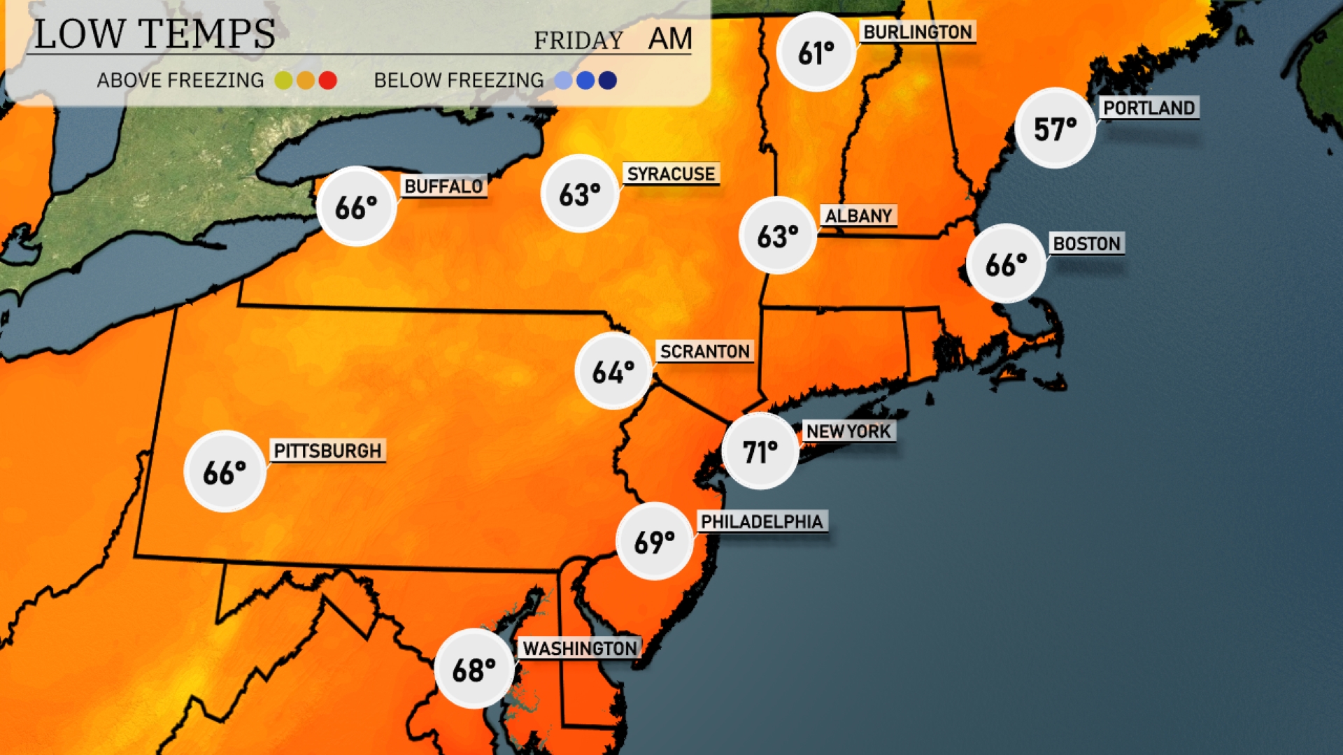
Tonight in the Northeast, temperatures are dropping significantly. New York City will see a low of 71 degrees, while Boston cools down to 66. Further inland, Scranton is forecasted to dip to 64 degrees, and Pittsburgh will also reach 66.
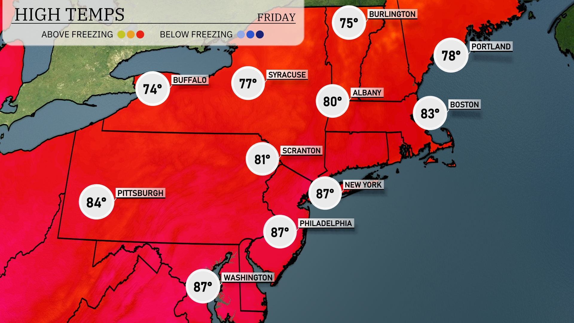
Tomorrow, Philadelphia and Washington will both reach a high of 87 degrees, well above the seasonal average. New York City and Scranton will follow closely with highs of 87 and 81 degrees, respectively. Up north, Boston will experience a warm afternoon, topping out at 83 degrees, while Albany warms to 80 degrees. Buffalo and Syracuse will enjoy milder conditions, with highs around 74 and 77 degrees, showing a noticeable cooling trend as you move northward in the region.
A cold front will sweep through the Northeast tomorrow morning, sparking a line of storms from Albany to New York City and Philadelphia. Expect heavy rain showers, with the potential for localized flooding and gusty winds. By afternoon, these storms head east toward Boston and the coastal areas, gradually clearing by evening. Temperatures dip slightly behind the front, bringing a cooler, more comfortable air mass into Friday.
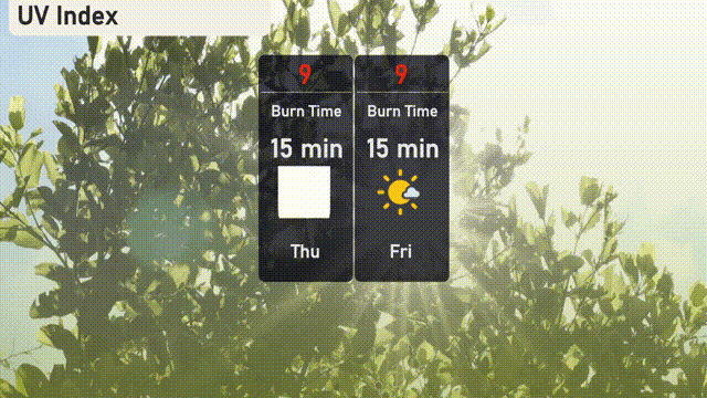
The UV index in New York City is high at 9 for both today and tomorrow. With intense sun exposure risk, the burn time is approximately 15 minutes.
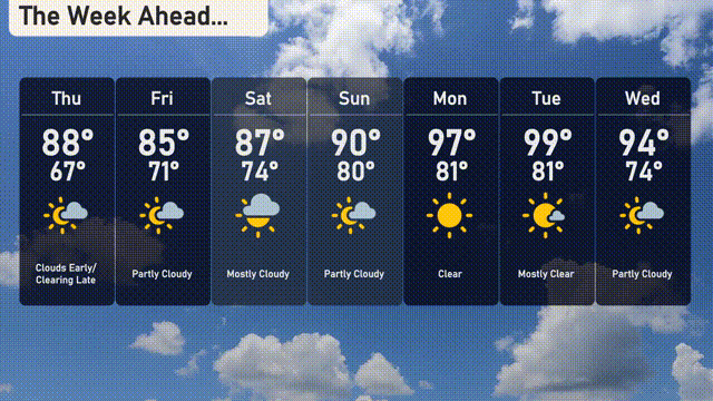
For the 7 Day Outlook in New York City:
Thursday: Clouds early, clearing late, with a high of 88 degrees and a low of 67 degrees.
Friday: Partly cloudy with the temperature reaching a high of 85 degrees and a low of 71 degrees.
Saturday: Mostly sunny skies with a high of 87 degrees and a low of 74 degrees.
Sunday: Partly cloudy and warmer, highs around 90 degrees and lows of 80 degrees.
Monday: Clear and sunny, peaking at 97 degrees and dropping to 81 degrees overnight.
Tuesday: Mostly clear skies with temperatures climbing to 99 degrees during the day and cooling to 81 degrees at night.
Wednesday: Partly cloudy conditions with a high of 94 degrees and a low of 74 degrees.