Chicago Evening Weather Update: From Sunshine to Storms
By
Amy Freeze
Catch up on the latest weather trends in Chicago and the broader Midwest region. From unexpected sunny spells to sudden severe storms, we're breaking down what to expect right outside your doorstep.
Tonight’s Chicago forecast promises a scenic sunset with a slight chill. As we watch temperatures gently drop, the Midwest battles mixed weather, from severe storms to pleasant highs. Stay tuned with us for more updates.
Welcome to our detailed coverage of the Midwest’s weather dynamics, particularly focusing on Chicago’s scenic yet unpredictable weather patterns. Experience the transition from a beautifully clear sunset to potential storm threats across the region. With temperatures fluctuating and severe weather warnings in place for parts of the Midwest, our comprehensive report prepares you for a week of diverse weather conditions. Keep an eye on the skies, and head to our blog for daily insights.
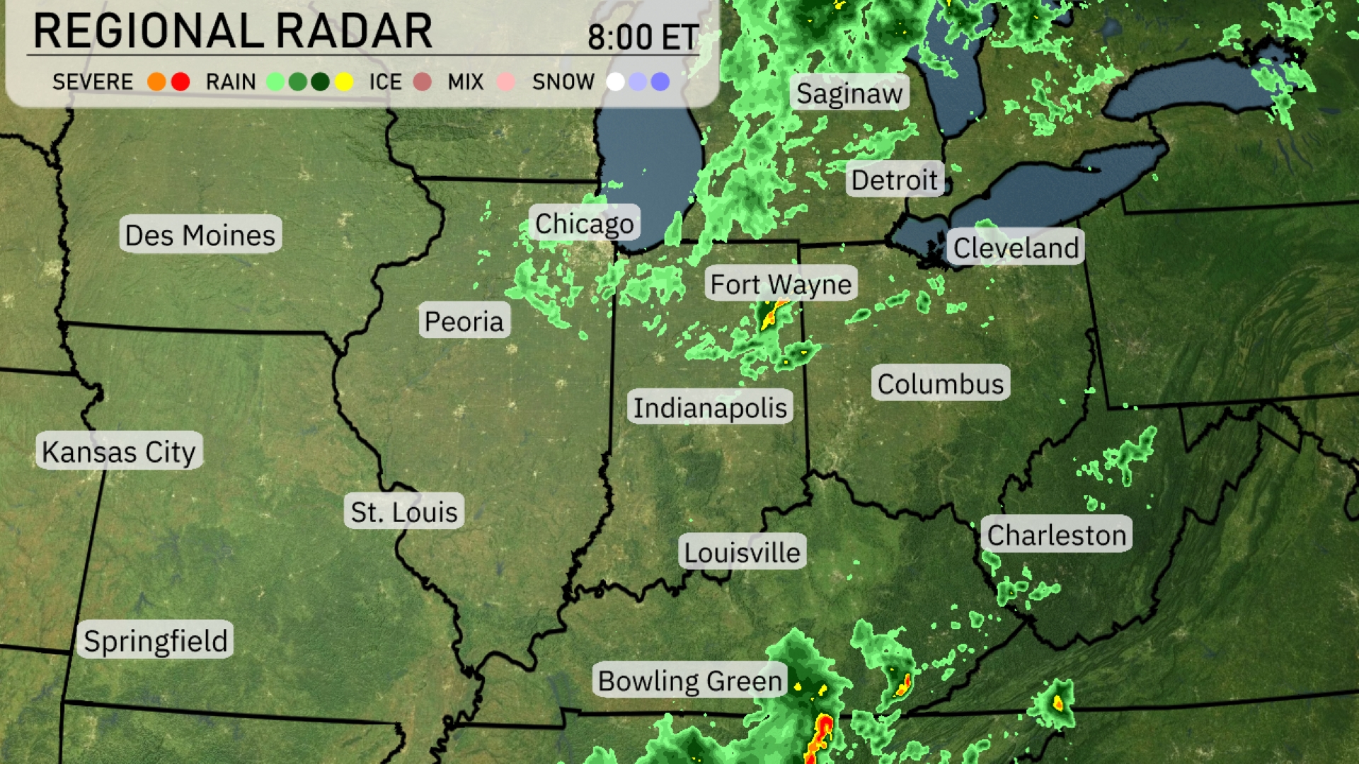
The Midwest is currently dealing with a mix of weather conditions. Fort Wayne and Bowling Green are experiencing pockets of severe storms moving through the region, bringing heavy rain and potential strong winds. Chicago and Indianapolis are seeing moderate rain showers, while Detroit is also wetting under a broad swathe of rain stretching from Saginaw to Cleveland. Clouds are thickening over St. Louis and Kansas City, setting the stage for potential evening rain showers.
For this evening in Chicago, temperatures will start at 78 degrees at 9 PM and gradually dip to 72 degrees by 1 AM. Expect mostly sunny skies at 9 PM, transitioning to clear conditions later in the evening. Winds will be light, coming from the west-southwest at 4 mph initially, shifting slightly to the southwest at 5 mph.
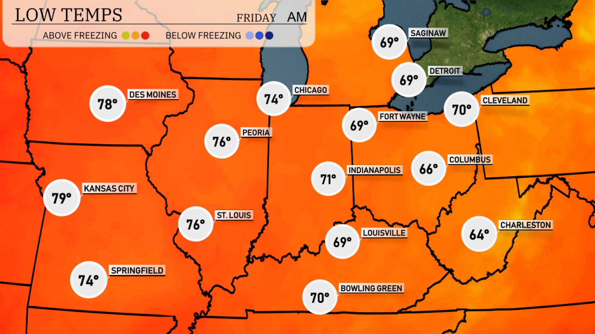
Tonight, low temperatures across the Midwest will vary, with Chicago dropping to 74 degrees and Indianapolis settling at 71. Expect a cooler night in Fort Wayne at 69 and Louisville at 69 as well. Columbus will see a low of 66 degrees, while Charleston cools down to 64.
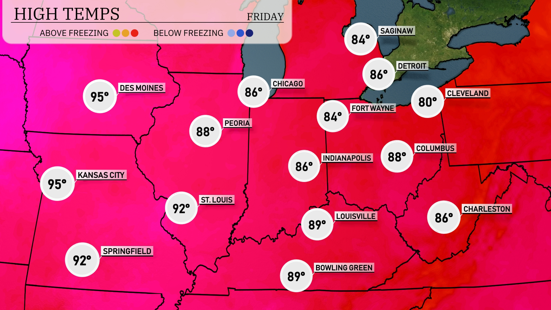
Tomorrow in the Midwest, Kansas City and Des Moines will both reach a sizzling 95 degrees, significantly above average for this time of year. St. Louis is set to see a high of 92 degrees, while Peoria tops out at 88 degrees. Chicago and Fort Wayne are expected to get to 86 degrees, staying warm but slightly cooler than areas farther south. Indianapolis and Columbus are both looking at highs near 88 degrees.
A warm front pushes through the Midwest tomorrow, bringing a brisk rise in temperatures. Expect scattered thunderstorms, particularly in areas around Indianapolis, Fort Wayne, and Bowling Green, with gusty winds. By afternoon, heavier downpours could move into Cleveland, potentially causing localized flooding. Keep an eye on the skies, as these storms may bring severe weather risks such as hail.
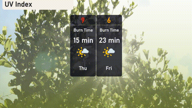
Today’s UV index in Chicago is set to be very high at 9, with a burn time of 15 minutes under direct sunlight. Make sure to wear sunscreen, hats, and protective clothing during outdoor activities to safeguard your skin. Tomorrow, the UV index will be moderate at 6, with a 23-minute burn time, so extra caution is still advised while enjoying the sunshine!
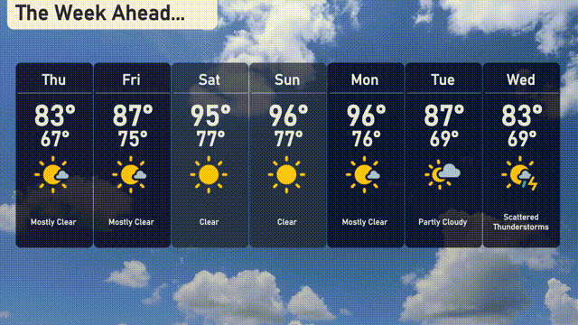
For the 7-day forecast in Chicago:
Thursday: Start with mostly clear skies, highs will reach 83 degrees and lows around 67 degrees.
Friday: The sun continues to shine with a high of 87 degrees and a low of 75 degrees.
Saturday: Expect a hot day with abundant sunshine, temperatures soaring to 95 degrees and a low of 77 degrees.
Sunday: Clear skies persist with another high at 96 degrees, dipping to 77 degrees overnight.
Monday: Mostly clear conditions continue, with highs around 96 degrees and nighttime lows of 76 degrees.
Tuesday: A slight decline in temperatures, partly cloudy skies with a high of 87 degrees and a low of 69 degrees.
Wednesday: Keep an eye out for scattered thunderstorms, temperatures will peak at 83 degrees and drop to 69 degrees.