Dive into a detailed weather forecast with Amy Freeze as she covers the varying conditions across the Midwest, from storm warnings to sunny surprises!
Meteorologist Amy Freeze provides a vivid update on this week’s Midwest weather, covering everything from icy roads to clear skies. Stay informed and prepared with her expert insights.
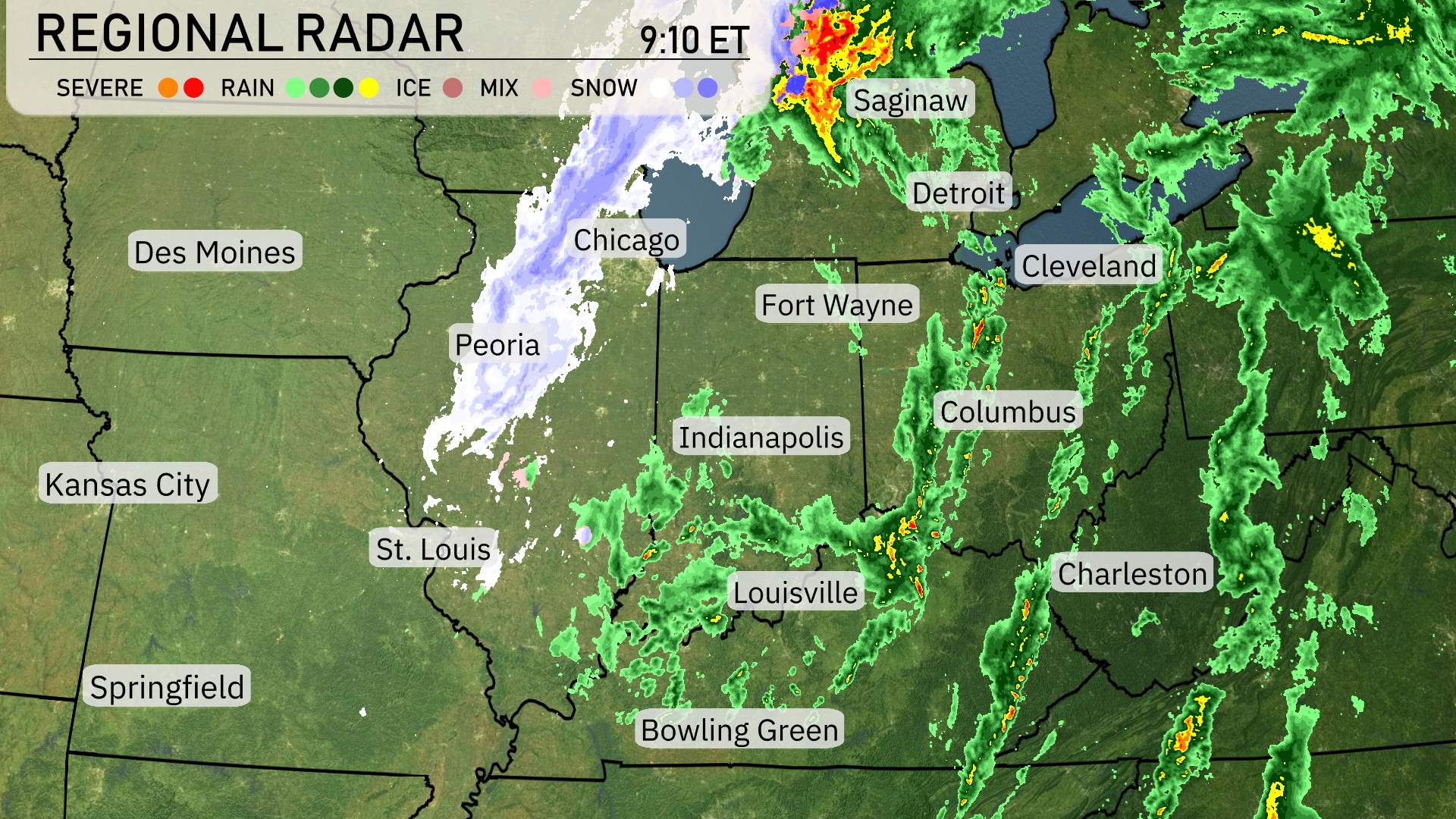
Welcome to your detailed Midwest weather forecast with Amy Freeze! This week, Chicago and surrounding regions will see everything from snow and thunderstorms to unusually warm temperatures and clear skies. Whether you’re in Peoria facing a winter wonderland or in St. Louis enjoying a break from the weather, our comprehensive guide has you covered. Amy’s expert analysis will help you plan your week with precision, from wardrobe choices to travel considerations. Don’t miss out on crucial updates and tips for handling everything from icy roads to sunny afternoons.
Currently, the Midwest radar is active with varied weather conditions across the region. Thunderstorms are intensifying between Detroit and Cleveland, with strong cells capable of producing heavy rain and lightning. To the north, Saginaw is seeing a mix of rain and ice, which could lead to slippery roads. Meanwhile, snow is coating areas west of Chicago and into Peoria, creating a winter wonderland but potentially impacting travel, so plan accordingly. Further south, Bowling Green is experiencing rain and occasional thunderstorms, with Louisville seeing overcast skies and scattered showers moving through. Indianapolis and Fort Wayne are under a blanket of light rain as clouds hover ahead of the storm system. However, St. Louis and Kansas City are currently clear of precipitation, enjoying a break from the weather.
In Chicago this afternoon, temperatures will slowly rise to 38 degrees by 5 PM, accompanied by a northwest wind at 10 miles per hour. Cloud cover will persist into the early evening, with conditions becoming partly cloudy by 7 PM, as temperatures dip slightly to 37 degrees and winds ease to 7 miles per hour.
Let’s take a look at the afternoon high temperatures across the Midwest. In Chicago, it’s a chilly day with a high of just 41 degrees, while Peoria also stays cool at 41 degrees. St. Louis warms up slightly to 47 degrees, and Indianapolis reaches 51. Heading south, we see a warmer trend with Louisville hitting 60 degrees and Bowling Green peaking at 61. Over in Kansas City, temperatures are more comfortable at 55 degrees. Notably, temperatures are noticeably cooler to the north compared to the southern parts of the region.
Now for the low temperatures in the Midwest tonight. Expect chilly conditions across the region. Chicago will see a low of 45 degrees, while Peoria drops to 48. Indianapolis is expecting a cooler night with a low of 43 degrees. Fort Wayne will be near freezing at 39, and Columbus is forecasted to hit 35 degrees. Heading south, St. Louis will be milder at 52 degrees, but to the east, Louisville will see a low of 41. Finally, Charleston rounds out our updates with a low of 33 degrees. Make sure to bundle up!
High temperatures across the Midwest for tomorrow are shaping up to be warm, with several areas experiencing above-average readings. Here’s a quick look at the expected highs:
Kansas City will see a high of 77 degrees, making it one of the warmest spots in the region.
Springfield also matches that with a high of 77 degrees, benefiting from a warm front moving through.
St. Louis can expect a comfortable 68 degrees, while Peoria warms up to 62 degrees.
Indianapolis will reach 55 degrees, slightly below the average for this time of year.
Louisville is forecasted to hit 56 degrees, while Bowling Green will see a high of 59 degrees.
Chicago anticipates a high of 54 degrees, which is on the cooler side. Fort Wayne and Detroit are both looking at highs of 50 degrees, with clouds and potential precipitation lingering.
Overall, much of the region will enjoy pleasant temperatures, significantly warmer than typical mid-March averages, driven by a warm air mass sweeping in from the south.
“Expect a shifting weather pattern across the Midwest tomorrow. Rain showers will slowly move eastward, impacting areas from St. Louis to Indianapolis with light to moderate precipitation. Chicago could experience a dry morning before rain arrives by afternoon. Be prepared for gusty winds along the Great Lakes, particularly near Cleveland and Detroit. A cold front pushing through later in the day may bring brief gusty winds and a chance for isolated thunderstorms. Temperatures will trend cooler post-front, with highs in the mid-40s by afternoon. Stay alert for any weather updates in these areas over the next 24 to 48 hours.”
The UV index in Chicago today remains low at just 2, thanks to the cloud cover diminishing sun exposure, so there’s minimal need for sun protection. Tomorrow, expect a moderate UV index of 4, with a potential burn time of approximately 35 minutes in direct sunlight. Stay sun-smart with protective measures if you’ll be outdoors.