Amy Freeze’s Evening Broadcast: Navigating the Southeast’s Stormy Skies
By
Amy Freeze
Meteorologist Amy Freeze provides an in-depth look at the unfolding storm systems across the Southeast, including what Miami expects tonight.
Meteorologist Amy Freeze highlights tonight’s weather in Miami and a stormy forecast for the Southeast. Stay weather-aware with her insights and safety tips!
Welcome to your detailed weather forecast with Amy Freeze. This evening in Miami, expect partly cloudy skies and a comfortable breeze. However, a robust storm system is stirring across the Southeast, poised to bring severe weather to places like Memphis and Jackson. From city-specific forecasts to safety precautions amidst these dynamic conditions, here’s everything you need to stay informed and prepared for the week ahead. For more, visit our full article.
A dynamic weather pattern is unfolding across the Southeast region. On the Regional Radar, we observe a robust line of severe storms advancing eastward from northeast Texas into western Louisiana, affecting areas such as Shreveport. Baton Rouge is experiencing moderate to heavy rainfall as these storms progress.
Farther northeast, scattered showers and thunderstorms are occurring over central Mississippi, impacting Jackson as the system moves toward Alabama. Meanwhile, Memphis is on alert as the storm line approaches the Tennessee border, bringing potential for intense weather.
In the Southeast, Georgia’s skies are showing increased cloudiness ahead of precipitation. The Carolinas, including cities like Charlotte and Atlanta, brace for similar conditions as rain makes its way eastward. Coastal areas, however, remain mostly dry for the time being, with Savannah and Jacksonville enjoying gentler weather.
For this evening in Miami, expect partly cloudy skies as temperatures settle in the upper 70s. Around 9 PM, temperatures will be at 79 degrees, maintaining this warmth through 11 PM. Winds from the east-southeast at around 13 to 14 miles per hour contribute to a breezy feel. By 1 AM, temperatures slightly dip to 77 degrees, with a persistent east-southeast wind at 14 miles per hour, keeping the evening feeling comfortable yet brisk.
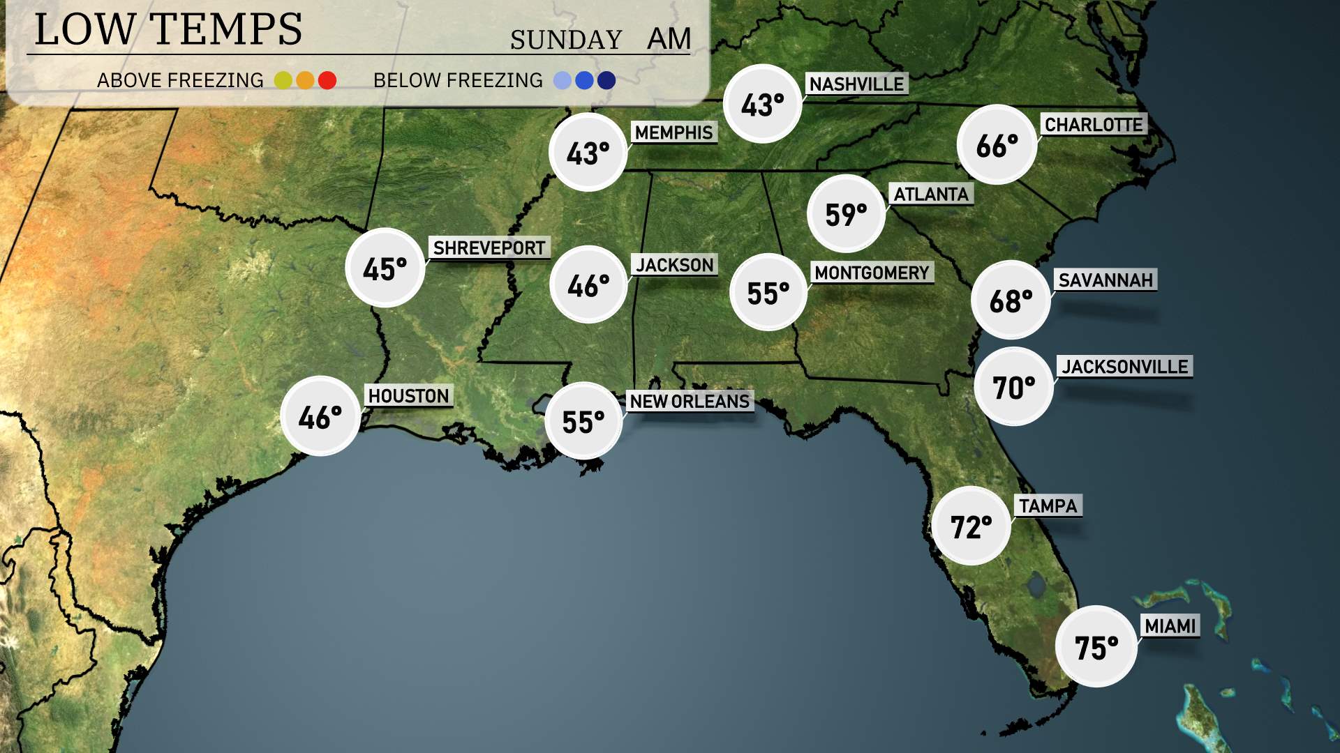
Memphis will see a low of 43 degrees. Nashville is expected to be just a bit cooler at 41. In Shreveport, nighttime temperatures will drop to 45. Jackson is looking at a low of 46 degrees. Montgomery will also feel the cool air, with temperatures dropping to 55. Atlanta will experience a low of 39 and further down the coast, Savannah sees 68 degrees. The mildest temperatures can be found in Jacksonville at 70, while Tampa and Miami will stay warmer at 72 and 75, respectively.
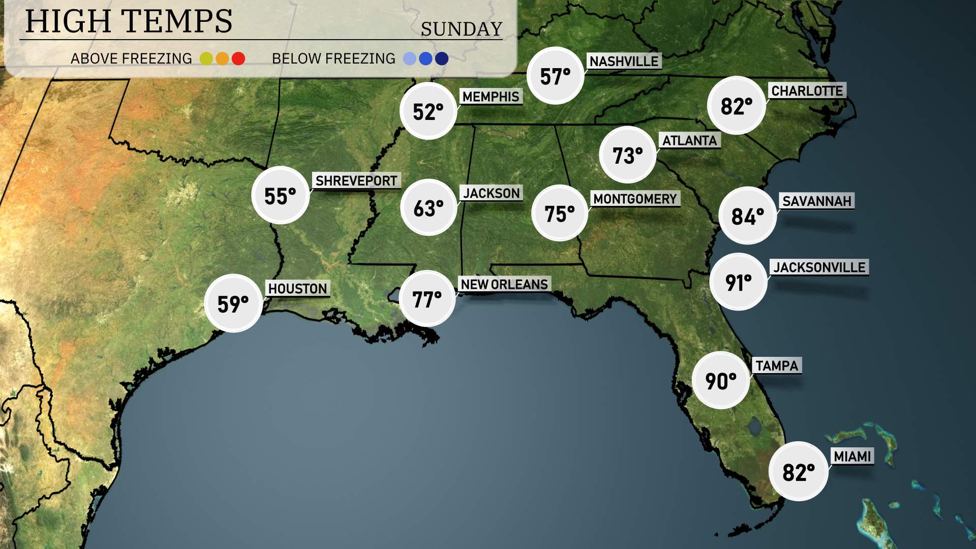
High temperatures in the Southeast are expected to rise significantly tomorrow, making for a warm day across the region. In Atlanta, the forecast calls for a high temperature of 73 degrees. Montgomery is set to see a high of 75 degrees, while further south in New Orleans, temperatures will climb to around 77 degrees.
Savannah is also heating up with a high of 84 degrees, and Jacksonville could reach a sizzling 91 degrees. Miami is expected to experience a high of 82 degrees.
On the futurecast for the Southeast, a significant weather pattern emerges. Expect a line of strong thunderstorms and showers progressing from Houston, through New Orleans, to Memphis, moving into Jackson and Shreveport by tomorrow morning. These storms may produce heavy rainfall and gusty winds, so be weather-aware and prepared for potential weather warnings.
In Atlanta and Charlotte, conditions remain relatively dry initially, but rain showers could develop by tomorrow evening as the front moves farther east. For those in Miami and Tampa, sunny conditions prevail, offering a more mild start to the weekend.
Temperatures across the region will see a cooling trend as the cold front passes, leading to a more mild end to the weekend. As always, stay informed and prepared for sudden weather changes, especially with the Storm Prediction Center highlighting areas for possible severe weather risks.
The UV index in Miami is expected to reach a very high level of 10 on both Saturday and Sunday, with a potential burn time of just 12 minutes. Make sure to apply broad-spectrum sunscreen, wear hats and sunglasses, and seek shade especially during midday hours when the sun is at its strongest. With the bright, sunny conditions anticipated, it’s important to limit your sun exposure for prolonged periods.
For the 7-day outlook in Miami:
Saturday: Expect partly cloudy skies with a high of 82 degrees and a low around 75.
Sunday: Another partly cloudy day, with both the high and low temperatures mirroring Saturday at 82 and 75 degrees respectively.
Monday: We’ll see mostly clear skies, with temperatures rising to a high of 84 degrees and dipping to 75 degrees at night.
Tuesday: Watch for scattered thunderstorms developing, with the day’s high reaching 82 degrees and the low cooling to 66 degrees.
Wednesday: Partly cloudy conditions are expected with a high of 80 degrees and a low of 69 degrees.
Thursday: The partly cloudy trend continues as temperatures peak at 79 degrees during the day and settle at 70 degrees overnight.
Friday: We conclude the week with clear skies and a high of 80 degrees, cooling to 67 degrees at night.