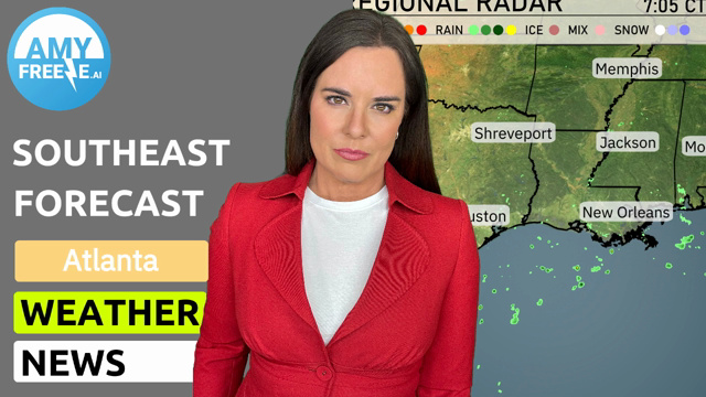
Dive into an in-depth look at the Southeast’s weather with Meteorologist Amy Freeze. From serene evenings in Atlanta to impending storms across the region, discover what’s brewing in the skies.
Meteorologist Amy Freeze provides the latest updates on the weather across Atlanta and the Southeast. Enjoy a clear evening in Atlanta with upcoming alerts for potential thunderstorms across the region.
Join Amy Freeze for a comprehensive look at the current and upcoming weather conditions across the Southeast. From a calm and clear evening in Atlanta to forecasts of strong thunderstorms affecting areas from Jackson to the Carolinas, this detailed guide covers temperature trends, storm warnings, and safety tips. Learn about the UV index in Atlanta and how to stay safe under varying weather conditions throughout the week. Whether you’re planning your week or just curious about the weather, this in-depth analysis offers everything you need to stay informed and prepared.
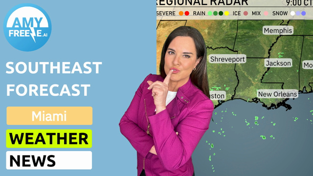
Over the Southeast region, the radar shows a calm atmosphere with no significant storm activity currently impacting the area. However, a notable cluster of rain and severe weather lies to the northeast, just brushing the upper corner near Charleston and Charlotte. Savannah and Jacksonville are enjoying clear skies as moisture stays farther north. A few showers are seen sprouting off the Gulf of Mexico, barely touching southeast Texas near Houston. Otherwise, the region remains dry and mild with pleasant conditions continuing across cities like Atlanta, Montgomery, and as far west as New Orleans.
For this evening in Atlanta, expect a gradual decrease in temperature with clear skies at 8 PM at 69 degrees. By 10 PM, conditions become mostly clear, and the temperature drops to 65 degrees with a south-southwest wind at 6 miles per hour. As midnight approaches, temperatures settle at 62 degrees under mostly cloudy skies, with a slight increase in wind from the south-southwest at 8 miles per hour.
Low temperatures tonight in the Southeast will bring some chillier air for many, particularly in the northern regions. Expect a brisk 33 degrees in Memphis and a cool 35 in Nashville. Further south, Jackson will see a low of 52 degrees, while Shreveport can expect around 51. Montgomery will be a bit cooler at 45 degrees, and Atlanta will wake up to 47. In terms of coastal cities, New Orleans will rest at a mild 61 degrees, with Tampa expecting a low of 65 and Miami going down to 70. Notably, temperatures are about 10 degrees lower in many areas compared to last night.
High temperatures for the Southeast region on March 24th will reflect a warm pattern influencing the area.
In Houston, expect a high of 84 degrees, well above average for this time of year. Shreveport will warm up to 81 degrees, also experiencing above-average temperatures. Jackson is set to reach 75 degrees, indicating a mild day. New Orleans will enjoy a high of 74 degrees, which is seasonally typical.
Moving east, Atlanta will see a high of 68 degrees, slightly below average, while Charlotte reaches 70 degrees. Jacksonville is forecasted for a warm 79 degrees, and Miami will top out at 82 degrees.
“Expect an active weather day across the Southeast as a front moves through the region. Strong thunderstorms are on the horizon, particularly from Jackson to Atlanta and extending to the Carolinas on Monday. Damaging winds are the main threat, with a chance of isolated tornadoes later in the day. Memphis, New Orleans, and Houston will see rain showers bringing needed moisture, while the line of storms advances eastward. Exercise caution on the roads during your morning commute due to slick conditions. Temperatures will remain steady, with cooler air moving in after the front passes.”
The UV index in Atlanta will be a high of 7 both today and Monday, with a burn time of about 20 minutes. Protect your skin by applying sunscreen, wearing hats, and seeking shade during peak sun hours. Keep an eye on passing clouds, but be prepared for sun exposure.
For the 7-day forecast in Atlanta:
Sunday: Expect thunderstorms late with a high of 79 degrees and a low of 56.
Monday: Partly cloudy skies, temperatures will reach a high of 69 degrees and a low of 43.
Tuesday: Enjoy clear skies with a high of 79 degrees and a low of 50.
Wednesday: Another clear day with temperatures peaking at 74 degrees and a low of 42 at night.
Thursday: Mostly clear, expect a daytime high of 73 degrees and a nighttime low of 44.
Friday: Mostly cloudy conditions with temperatures reaching a high of 79 degrees and a low of 55.
Saturday: Mostly cloudy again, slightly warmer with a high of 81 degrees and a low of 60.
Stay safe!