April Showers & Sunshine: Amy Freeze’s Detailed Southwest Weather Forecast for 04/04/2025
By
Amy Freeze
Explore what your day looks like with a comprehensive weather update from Amy Freeze. From the clear skies in Salt Lake City to the unexpected snow in Cedar City, here’s everything you need to know for April 4th, 2025.
Catch up with the latest weather trends across the Southwest as meteorologist Amy Freeze breaks down the forecast for April 4th, 2025. Whether it’s sunny or snowy, be prepared!
Good morning, Southwest residents! Meteorologist Amy Freeze here with your detailed weather forecast for April 4th, 2025. We’re seeing diverse weather conditions across the region—from thunderstorms in Flagstaff to calm, sunny days in Salt Lake City. Interested in the specifics for your area and what to expect from temperatures and UV indexes over the coming days? Dive into the full update in today’s blog post. Stay weather-wise and safe!
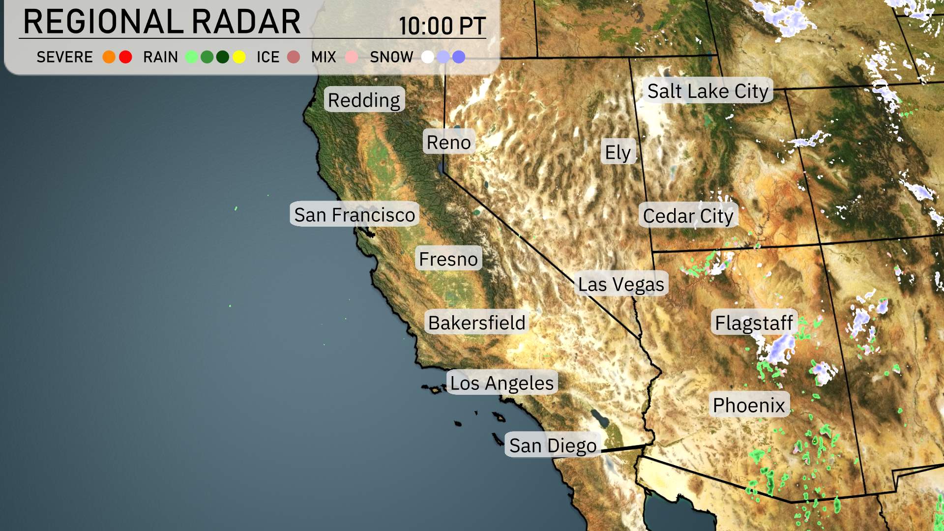
The Southwest region is experiencing a mixed bag of weather today. The radar shows a significant area of thunderstorm activity centered around Flagstaff, where rain is combined with some potential thunderstorms. Meanwhile, Ely, Nevada, remains dry with clear skies, offering a stark contrast to the more active weather moving through other parts. Over in Cedar City, Utah, light snow is falling, making for a wintery mix in higher elevations.
To the west, Reno and Redding are enjoying clear and calm conditions, with no precipitation on the radar. Along the California coastline, from San Francisco down through Los Angeles, the weather is generally mild with a few isolated rain showers near Fresno and Bakersfield, but nothing substantial. San Diego and the surrounding areas are also experiencing dry and pleasant conditions this evening.
Meanwhile, the Phoenix area is seeing patches of rain developing, bringing much-needed moisture to the desert region. As you move farther northeast, Salt Lake City is staying dry for the moment, but with the possibility of changes as the system progresses.
In Salt Lake City, tomorrow morning is starting clear, transitioning to sunny skies as the day progresses. Temperatures begin at 34 degrees and hold steady until 10 AM, gradually rising to 41 degrees by noon. Winds are from the east at 7 mph, shifting slightly to the northeast at 5 mph by midday. Expect a bright morning under sunny conditions.
For tomorrow in the Southwest region, we’re expecting some impressive highs as warm air continues to dominate.
In California, Los Angeles will see a high of 77 degrees, with Bakersfield reaching a comfortable 79. San Francisco, however, remains cooler at 68 degrees, and the coastal influence keeps it mild.
Heading into Nevada, Las Vegas will be warm at 75 degrees, while Ely remains cool at just 54.
In Arizona, Phoenix will soar to a balmy 79 degrees, aligning well with seasonal averages.
Overall, these temperatures are either on par or slightly above average for this time of year, driven by a consistent warm air mass across the region.
For the Southwest, a mostly clear and sunny forecast prevails, particularly over the desert areas, making for a pleasant day. However, attention shifts to the Sierra Nevada region, where scattered showers and the potential for snow at higher elevations are expected as a storm system impacts northern California through Wednesday. The weather may lead to slippery roads and reduced visibility, especially over mountain passes, so be cautious while traveling. Farther east, through southern Nevada and into Arizona, conditions remain dry and rather warm with no significant weather disruptions anticipated.
The UV index in Salt Lake City will be moderate on Friday with a value of 5, indicating potential sun exposure risks with a burn time of about 27 minutes in direct sunlight. As we head into Saturday, the UV index rises to 6, making the sun moderately strong with a quicker burn time of 23 minutes! Be sure to apply sunscreen and wear protective clothing if you’re planning to be outdoors.
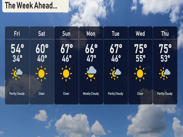
Friday: Partly cloudy skies with highs reaching 54 degrees and lows dipping to 34 degrees.
Saturday: Clear and sunny, warming up to 60 degrees during the day, with a low of 40 degrees.
Sunday: Enjoy clear weather with a high of 67 degrees and nighttime lows around 46 degrees.
Monday: Mostly cloudy but staying warm with a high of 66 degrees and a low of 47 degrees.
Tuesday: Partly cloudy skies with temperatures rising to 67 degrees and a low of 46 degrees at night.
Wednesday: Clear and warmer with a high of 75 degrees and a low near 55 degrees.
Thursday: Partly cloudy, maintaining the warmth with a high of 75 degrees and lows around 53 degrees.
Hope that helps! Enjoy the weather in Salt Lake City!