From Drizzles to Downpours: Amy Freeze Explores the Dynamic Weather of the Southwest
By
Amy Freeze
Unpack the current weather trends in the Southwest with Amy Freeze. From soothing showers in California to chilling lows in Ely, get the full scoop!
Dive into this comprehensive weather update by Amy Freeze, featuring the varied conditions across the Southwest. Whether it’s rain in California or sunny skies in Nevada, we cover it all!
Catch the latest insights from Amy Freeze as she navigates through the diverse climate conditions across the Southwest. From the comforting warmth in Phoenix to unexpected snow in Reno, stay informed with our detailed forecast. Read more about what these changes mean for you and how to stay prepared, no matter the weather.
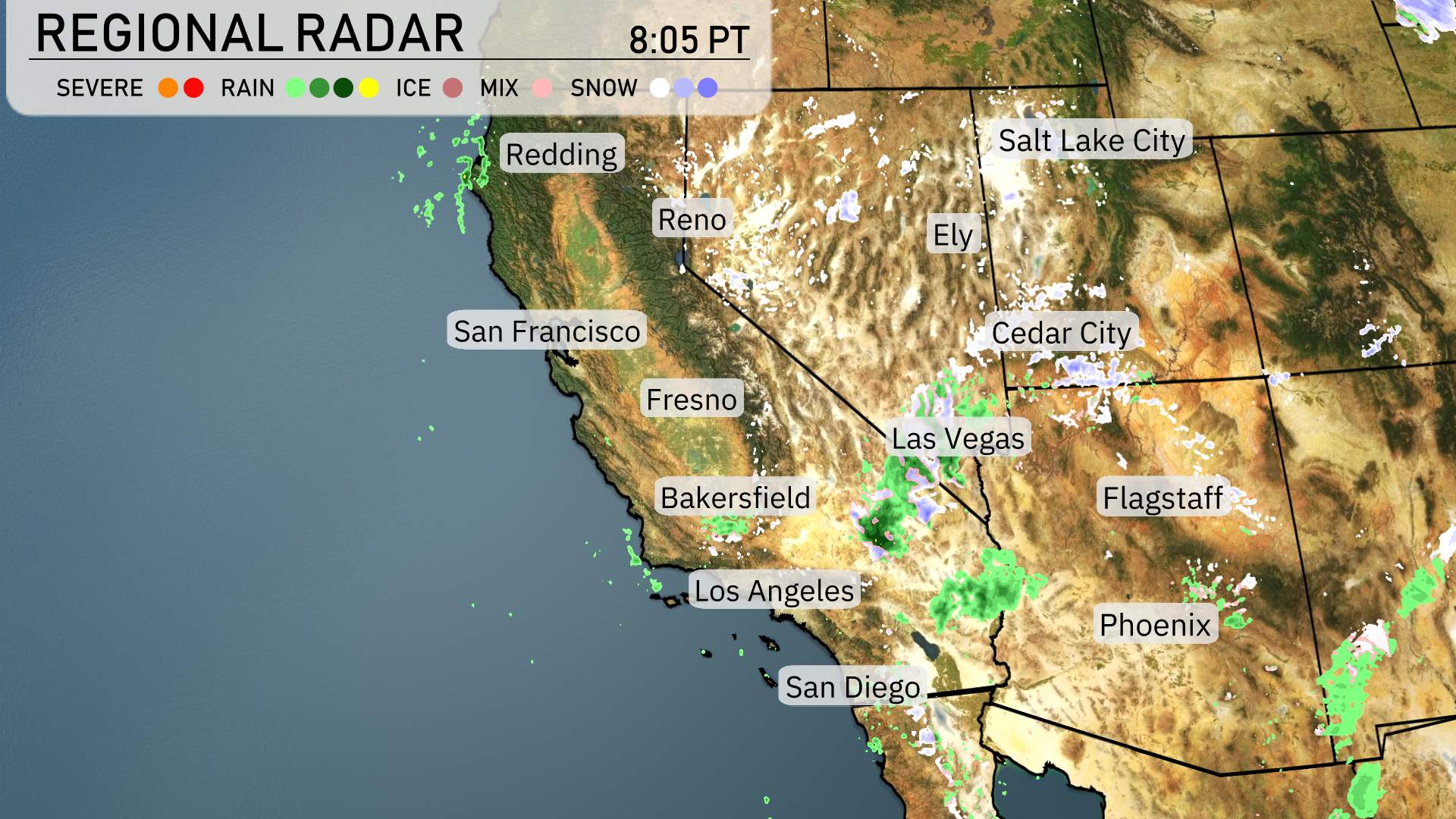
The Southwest region is currently witnessing varied weather conditions. There is a significant band of rain impacting the California coast, with a strong emphasis on Central California where showers are providing much-needed rainfall. These showers extend into the valleys, while snow is falling over the Sierra Nevada’s higher elevations. Moving east, the Los Angeles Southland is experiencing only a light drizzle, contributing to a relatively mild start to the day.
In Nevada, Ely is seeing clear conditions, while Las Vegas stays dry as well, devoid of any rain or snow activity. However, farther north in Reno, light snow flurries are apparent, possibly dusting the landscape. Cedar City is under cloud cover, hinting at potential precipitation in the coming hours, although currently, the area remains clear of rain.
This diverse weather scenario does highlight some icy spots in Utah and scattered snow showers across higher terrains, which suggests travelers should remain cautious while navigating these areas.
For this evening in Salt Lake City, temperatures will drop from 43 degrees at 8 PM to 36 degrees by midnight. Winds will shift slightly from the northwest at 8 miles per hour to east at 5 miles per hour as the night progresses.
Tonight in the Southwest, in Ely, expect a brisk low of 21 degrees. Cedar City will not be far behind, with a forecasted low of 25 degrees. Flagstaff is looking at a chilly 22. Las Vegas will be milder at 46 degrees, while Bakersfield is expected to drop to 45 degrees. San Francisco will see a low of 46, and Fresno will cool down to 43. Overnight, Phoenix stands out with a relatively warm 52 degrees. Stay warm, Southwest!
High temperatures in the Southwest for tomorrow are expected to show a mix of seasonal and above-average readings.
In Las Vegas, temperatures are projected to reach 62 degrees, which is right on target for early April. Moving south to Phoenix, we see a notable rise, with a high of 70 degrees, reflecting warmer conditions.
Farther west, Los Angeles will experience a mild day with highs around 63 degrees, slightly below the seasonal average but still comfortable. In Fresno, highs will be more robust at 66 degrees, showcasing a warming trend compared to earlier this week.
Northern California will be cooler, with San Francisco expecting just 61 degrees. Bakersfield will also see a high of 66 degrees, indicating consistent warmth across the region.
In the Southwest, a surge of moisture brings scattered showers to Southern California through tomorrow, particularly affecting the San Bernardino Valley. Be cautious of wet roads and reduced visibility in mountain areas. Farther inland, Nevada and Arizona experience clearer skies with more mild temperatures. However, a low-pressure system over Northern California contributes to increased rainfall with potential thunderstorms. Those traveling through mountain passes should anticipate possible snow head on.
The UV index for Salt Lake City will be moderate, at 5 both Wednesday and Thursday, with a burn time of approximately 27 minutes in direct sunlight.
For the 7-Day Forecast in Salt Lake City:
Wednesday: Partly cloudy with a high of 43 degrees and the temperature dropping to 28 degrees overnight.
Thursday: Expect mostly sunny skies with a high of 47 degrees and a low of 30.
Friday: Mostly clear conditions, with temperatures climbing to a high of 50 degrees during the day and cooling to 30 at night.
Saturday: Enjoy partly cloudy weather, as temperatures reach a high of 53 degrees and drop to 33 degrees later.
Sunday: Mostly clear conditions will persist, with a pleasant high of 58 degrees and a low of 38 degrees.
Monday: The trend continues with partly cloudy skies, a high temperature of 65 degrees, and the temperature dipping to 43 degrees at night.
Tuesday: Mostly clear skies remain, with a daytime high matching Monday at 65 degrees, cooling to 45 overnight.