Atlanta: From Sun to Storms – A Week of Weather Whiplash
By
Amy Freeze
Explore how Atlanta transitions from partly cloudy mornings to stormy afternoons this week, with a close look at temperatures and storm forecasts across the Southeast.
This week in Atlanta forecast involves partly cloudy mornings paving way to stormy afternoons with potential heavy rainfall. Stay tuned to how these conditions evolve across the Southeast.
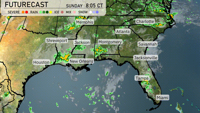
Atlanta Tomorrow Morning News – 06/15/2025: Starting your morning with partly cloudy skies and a calm breeze might seem ideal, but don’t be fooled. A series of strong storms are set to bring severe weather across the Southeast, starting from Shreveport and sweeping through Atlanta. From temperature highs and chilling lows to storm advisories, read on as we prepare you for a week of unpredictable weather, optimally mapping out your week with our 7-day forecast.
A line of strong storms is sweeping across the Southeast from Shreveport into parts of eastern Texas, bringing severe weather conditions. Showers are developing around New Orleans, with rain tracking northward towards Jackson and Montgomery, indicating increasing precipitation in these areas. Light showers are dispersed across central Florida, with Jacksonville and Tampa seeing more humidity. Areas like Atlanta and Charlotte remain clear for now but should brace for incoming cloud cover as the system moves eastward.
In Atlanta, tomorrow morning starts off partly cloudy, with temperatures rising from 73 degrees at 8 AM to 79 degrees by 10 AM. Expect a slight breeze with winds from the southwest at 4 miles per hour, increasing to 6 miles per hour mid-morning. By noon, temperatures climb to 82 degrees, maintaining the partly cloudy skies as winds continue from the southwest at 7 miles per hour.
Tomorrow, high temperatures in the Southeast will be quite warm. Atlanta is expected to hit 88 degrees, while Montgomery reaches a sizzling 90. Over in Jacksonville and Savannah, temperatures will also soar to around 91 degrees. New Orleans stays comfortable at 85 degrees, with Houston matching that mark at 87.
A vigorous cold front sweeps through Southeast tomorrow, igniting thunderstorms from Houston to Atlanta, with potential for heavy rain and strong winds. Be prepared for over an inch of rain, especially from Shreveport to Jackson, which could trigger localized flooding. By evening, rain showers spread towards Savannah and Jacksonville, cooling temperatures slightly behind the front. In the afternoon, expect storms possibly disrupting afternoon plans in New Orleans and Birmingham. Enjoy cooler temperatures post-storms, as the region gradually dries out toward Wednesday.
Atlanta will experience a moderate UV index of 8 on Sunday, with sun exposure risks leading to a burn time of about 17 minutes. As the week begins on Monday, the UV index climbs to 10, making protection even more crucial with potential burns occurring in just 12 minutes.
For the 7-day forecast in Atlanta:
Sunday: Partly cloudy with temperatures peaking at 87 degrees and dipping to 70 degrees at night.
Monday: A mix of sun and clouds. Expect a warm high of 89 degrees and a low of 71 degrees.
Tuesday: Partly cloudy skies continue with a high of 87 degrees and a low of 70 degrees.
Wednesday: Conditions remain partly cloudy, reaching a high of 87 degrees and a nighttime low of 71 degrees.
Thursday: Enjoy mostly cloudy skies with the temperature soaring to 87 degrees during the day and dropping to 70 degrees in the evening.
Friday: Mostly clear and a bit warmer, with a daytime high of 90 degrees and a low near 70 degrees.
Saturday: Mostly clear skies wrap up the week with a hot high of 92 degrees and a low of 72 degrees.