Atlanta Morning Mosaic: A Snapshot of Tomorrow’s Skies
By
Amy Freeze
As Atlanta enters another diverse weather day, get the full scoop on the morning forecast, regional temperatures, and impending thunderstorms. Stay informed and prepared for shifting patterns and potential severe conditions.
Tomorrow morning in Atlanta promises partly cloudy skies with temperatures starting at a cool 68°F. A cold front might spice things up by evening, bringing potential severe thunderstorms. Stay tuned and prepared!
As Atlanta prepares for another varied weather day, tomorrow morning greets us with partly cloudy skies and an inviting 68°F. As the day progresses, keep an eye out for a cold front sweeping in by nightfall, which could lead to severe thunderstorms and significant temperature shifts. With highs peaking at 65°F and storms on the horizon, it’s a critical time to stay informed and prepared. As always, Amy Freeze brings you the latest and most accurate weather updates to help you plan effectively.
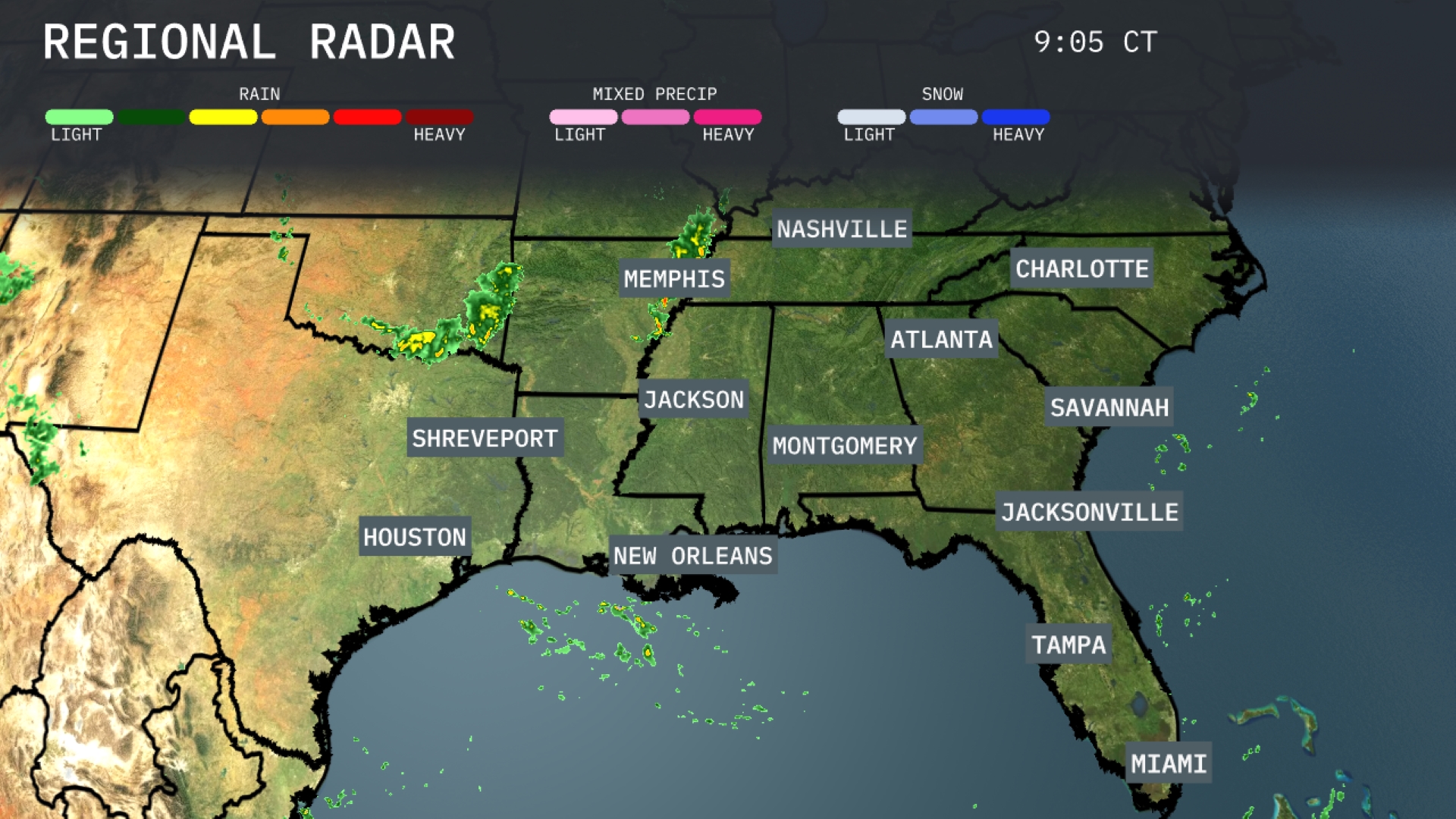
A line of showers is making its way through Arkansas towards Memphis, bringing moderate rain to the area. New Orleans and its vicinity are experiencing scattered rain showers moving east, indicating wet conditions along the Gulf Coast. Meanwhile, light rain is moving into coastal regions of Georgia, including Savannah, as clouds increase across the region. Areas from Atlanta to Charlotte are currently dry but cloud cover is beginning to increase ahead of the rain expected to move in later.
Temperatures in Atlanta tomorrow morning start at 68 degrees with partly cloudy skies. A light north-northeast breeze will blow at 5 to 10 miles per hour, providing a pleasant feel to the morning.
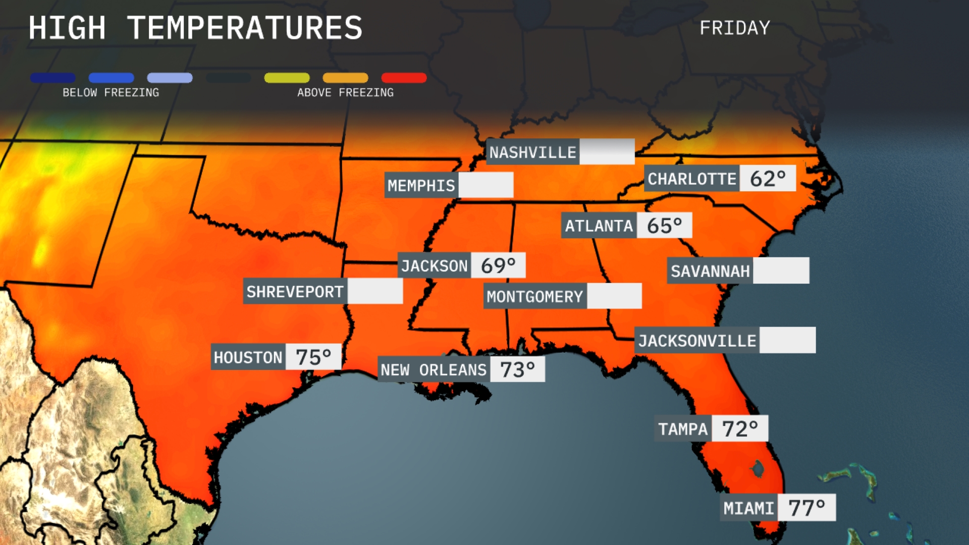
Tomorrow in Atlanta, afternoon highs will reach 65 degrees, while Nashville sees a slightly cooler day at 62. Memphis will warm up to 69 degrees, and Jackson can expect a high of 69 as well. In the Gulf area, temperatures will be milder; New Orleans hits 73, and Houston is on track for 75 degrees. Tampa and Miami will enjoy warmer conditions, with highs of 72 and 77 degrees respectively, indicating a consistent above-average trend across the region.
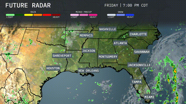
A cold front is progressing eastward, bringing potentially severe thunderstorms from Shreveport to Montgomery by late Friday night. Expect heavy rainfall and gusty winds with this system, especially impacting Memphis and Jackson with scattered showers. By Saturday, the front will slow, maintaining conditions conducive to thunderstorms from New Orleans through Jacksonville, raising the risk of flash flooding. Temperatures will drop behind the front, bringing cooler, drier air to Nashville and Charlotte. Keep an eye on changing weather patterns as this system could lead to isolated severe weather impacts across the southeast.
The UV index in Atlanta is high today with a value indicating a 17-minute burn time in direct sunlight—so applying sunscreen and seeking shade is crucial. Tomorrow, expect similar conditions, with the UV index remaining high and burn time again at 17 minutes.
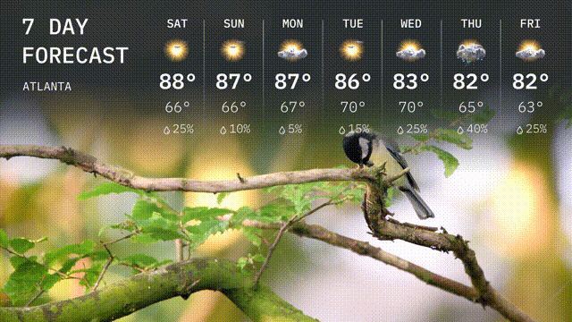
Saturday: Atlanta is in for sunshine with a high of 88 degrees and overnight low of 66 degrees.
Sunday: Another sunny day, the high reaches 87 degrees while the low hits 66 degrees.
Monday: Expect partly sunny skies with the temperature peaking at 87 degrees and dropping to 67 degrees after dark.
Tuesday: A sunny start with temperatures climbing to 86 degrees and cooling to 70 degrees at night.
Wednesday: Clouds start to roll in, with a high reaching 83 degrees and a low of 65 degrees.
Thursday: More clouds with a possibility of rain, a high of 82 degrees and a low of 65 degrees.
Friday: Partly sunny, high of 82 degrees and low of 63 degrees.