Atlanta Scorching: This Week’s Extreme Weather Forecast
By
Amy Freeze
From near triple-digit highs to unexpected thunderstorms, get the insider’s view on how Atlanta is coping with an extreme weather week.
Explore Atlanta’s intense weather this week with highs soaring and storms looming. Find out everything you need to stay safe and informed.
Atlanta is currently experiencing one of its hottest weeks, with temperatures reaching up to 99 degrees. This has led to extended sun exposure risks and expected thunderstorms that might bring severe weather conditions. Our comprehensive weather update covers daily insights, from nightly temperature drops to how you should prepare for potential flooding due to heavy rains. Always stay ahead by being weather-wise!
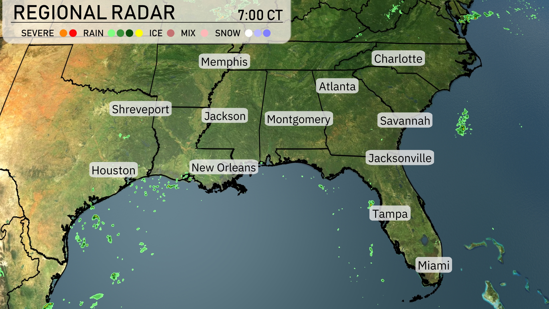
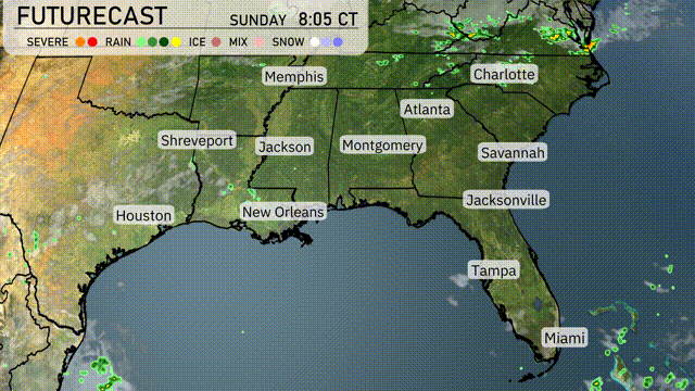
On the Regional Radar, isolated rain showers can be seen across the Gulf of Mexico moving towards the coastlines of Northern Florida. Houston is experiencing a few scattered showers, likely to move eastward. Meanwhile, skies are mostly clear over Memphis, Charlotte, and Savannah, providing a brief respite from any precipitation. The overall pattern suggests a calm start, but be prepared for some weather developments later on.
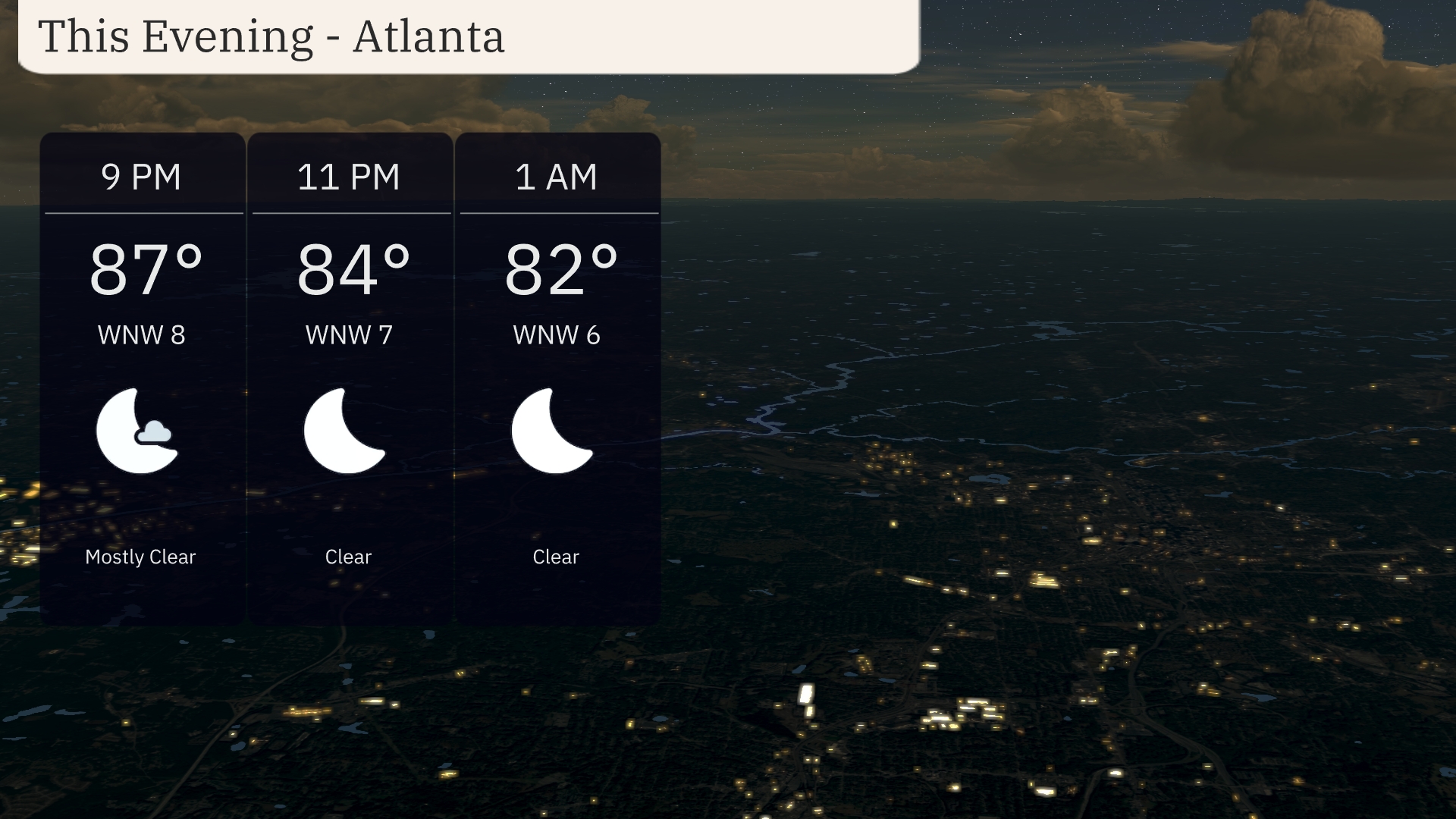
For this evening in Atlanta, temperatures start at a warm 87 degrees at 9 PM, cooling slightly to 82 degrees by 1 AM. Skies are expected to be mostly clear throughout the night. Winds will be light, from the west-northwest at 8 miles per hour at 9 PM, gradually decreasing to 6 miles per hour by 1 AM. A pleasant evening is in store with high pressure maintaining clear skies over the region.
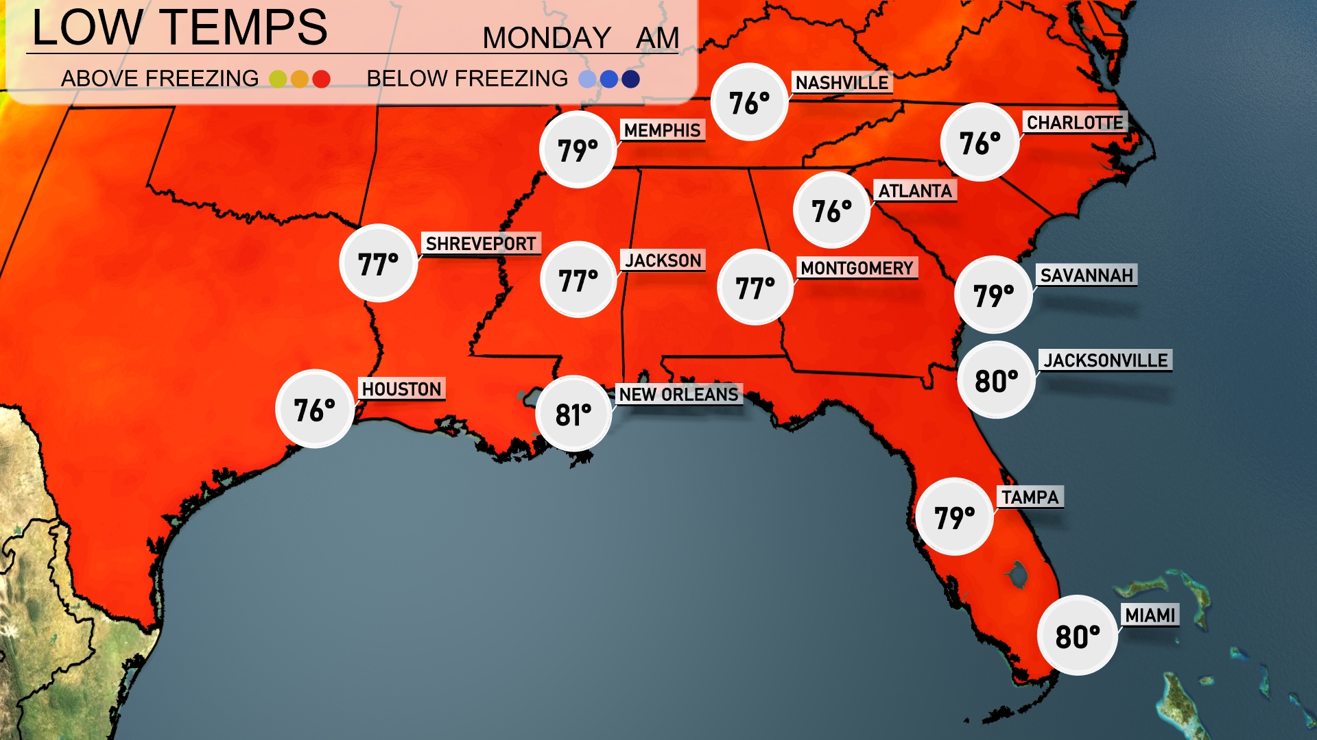
Tonight, Memphis will cool down to 79 degrees. Expect a low of 77 in Jackson, along with Montgomery also sitting at 77. Shreveport will share similar nighttime temperatures at 77. Meanwhile, Miami will remain pleasantly warm at 80 degrees, while Jacksonville will only drop slightly to 80 as well.
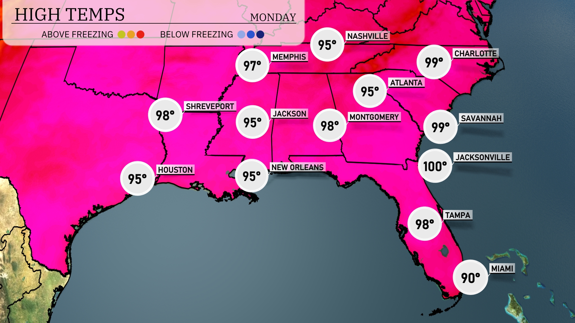
Tomorrow, Atlanta will reach a sizzling 99 degrees, significantly above average for this time of year. Jacksonville is poised to break records with a blistering high of 100 degrees, while Tampa will also see warm conditions at 98 degrees. New Orleans and Houston are both expected to hit 95 degrees, maintaining their seasonal warmth. Overall, the Southeast is experiencing a heat wave influenced by high pressure systems, leading to these elevated temperatures across the region.
A cold front is pushing into the Southeast, bringing widespread thunderstorms from Houston to New Orleans by late Monday night. Expect heavy rain and robust winds, with the potential for isolated severe storm events, especially near coastal areas. By Tuesday, rainfall will spread further into Jacksonville and Savannah, with showers persisting throughout the day. Temperatures in these regions will dip slightly but remain humid, requiring vigilance for possible flooding. The front clears by Wednesday, leaving behind cooler, drier air for the midweek.
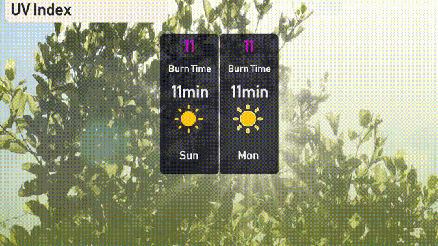
The UV index in Atlanta will reach a very high level of 11 today and on Monday, posing a significant sunburn risk within just 11 minutes of exposure. It’s crucial to seek shade, apply a broad-spectrum sunscreen with a high SPF, and wear protective clothing when outdoors. Stay sun-safe!
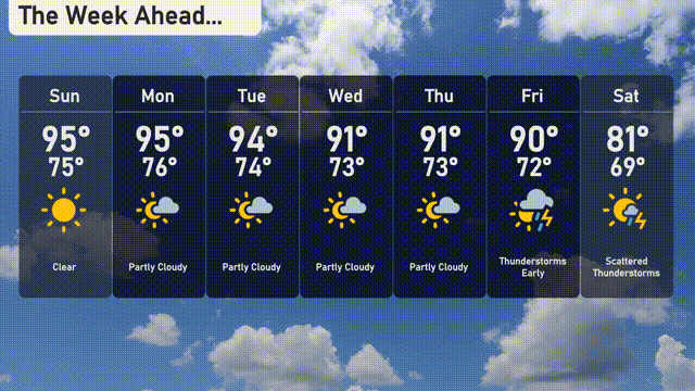
For the 7 Day Forecast in Atlanta:
Sunday: Clear skies with a high of 95 degrees and a low of 75 degrees.
Monday: Partly cloudy, maintaining a high of 95 degrees and a low of 76 degrees.
Tuesday: More partly cloudy conditions, slightly cooler with a high of 94 degrees and a low of 74 degrees.
Wednesday: Partly cloudy skies again, with temperatures reaching up to 91 degrees and dipping to 73 degrees at night.
Thursday: Another partly cloudy day, a high of 91 degrees and a low of 73 degrees.
Friday: Thunderstorms expected early, with the temperature hitting 90 degrees and cooling to 72 degrees.
Saturday: Scattered thunderstorms are likely, with a high of 81 degrees and a low of 69 degrees.
Hope that helps! Stay safe!