Atlanta and Southeast Weather: A Symphony of Clouds and Sun
By
Amy Freeze
Join Amy Freeze as she guides you through the partly cloudy vistas and sunny highs expected in Atlanta and across the Southeast tomorrow. Get the complete forecast and what it means for your day!
Tomorrow’s forecast in Atlanta calls for cloudy skies with a chance of sun. Amy Freeze brings you the latest weather updates and insights for the Southeast. Don’t miss out on our full coverage!
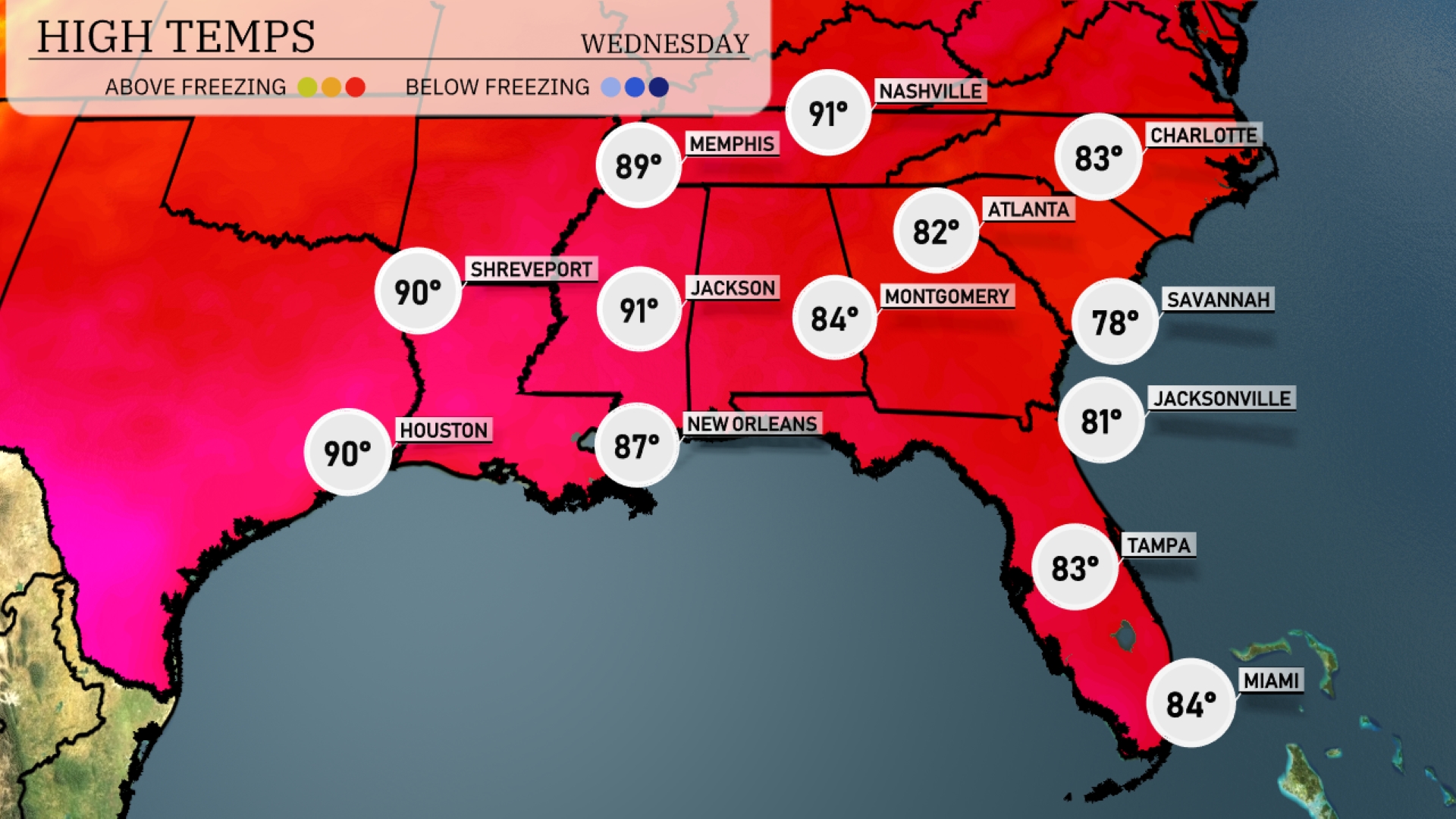
Welcome to your definitive guide for tomorrow’s weather in Atlanta and the surrounding Southeast region. With Amy Freeze at the helm, get ready to navigate through intermittent clouds, potential rain showers, and pleasant temperature highs. This detailed report covers everything from localized forecasts to expected weather phenomena across different cities. Stay ahead of the weather curve with Amy’s expert insights and prepare for everything Mother Nature has in store. The Southeast region is experiencing scattered thunderstorms mainly off the coast of Florida, with Miami seeing some heavy rainfall. Rain showers are also developing in southern Florida and moving northeast. Jacksonville is witnessing overcast skies with potential rain on the radar. Meanwhile, the Gulf Coast from New Orleans to Houston appears clear for now, although clouds are approaching from the west. Areas like Shreveport, Memphis, and onto Charlotte remain dry, enjoying clear conditions. Tomorrow morning in Atlanta, the day starts mostly cloudy with temperatures at 70 degrees by 8 a.m., accompanied by an east-southeast breeze at 7 miles per hour. By 10 a.m., temperatures rise to 74 degrees as the wind shifts from the east at 8 miles per hour, maintaining the mostly cloudy skies. Expect continued clouds at noon with temperatures reaching 78 degrees and an easterly wind at 10 miles per hour. Tomorrow in Memphis, expect a high of 89 degrees, while Nashville will reach 91, both of which are above average for early June. Jackson will see even warmer temperatures at 91 degrees, along with Shreveport matching that high. New Orleans is forecasted for a milder day at 87 degrees, but still on the warmer side for this time of year. Cooler readings in the Southeast include Montgomery at 84 degrees, with Jacksonville slightly behind at 81 degrees. The Southeast is set for an active weather pattern tomorrow. A cold front is expected to extend from Houston through Shreveport, bringing thunderstorms as it moves eastward. Strong storms are likely, particularly in New Orleans and up through Montgomery, with potential heavy downpours and gusty winds. Jacksonville to Charlotte should brace for showers and isolated storms, as the weather system advances. Be prepared for moderate temperature drop and clearing skies by late Wednesday, bringing cooler, drier conditions. The UV index in Atlanta is quite high on Tuesday at 10, with a burn time of just 12 minutes, so take extra precautions if you’re spending time outdoors. On Wednesday, the UV index drops to 8 due to increased cloud cover, with a slightly longer burn time of 17 minutes. Keep your sunscreen and protective gear handy to stay safe from the sun! For the 7 Day Outlook in Atlanta:
Tuesday: Expect mostly clear skies with a high of 87 degrees and a low of 67 degrees.
Wednesday: Partly cloudy conditions with temperatures reaching 82 degrees, and a low around 67 degrees.
Thursday: Another partly cloudy day, warming up to 86 degrees with a low staying at 67 degrees.
Friday: Be prepared for showers in the evening, high of 89 degrees and a low of 71 degrees.
Saturday: Scattered thunderstorms may pop up, with temperatures peaking at 87 degrees and dropping to 68 degrees at night.
Sunday: Thunderstorm activity early in the day, with a high of 81 degrees and a low of 66 degrees.
Monday: The week rounds off with partly cloudy skies and a high of 84 degrees, dipping down to 67 degrees.