Under the Clouds: Atlanta’s Weather Forecast Unveiled by Amy Freeze
By
Amy Freeze
Dive into a detailed weather forecast for Atlanta and the Southeast as Amy Freeze breaks down the latest conditions and what to expect in the coming days.
Meteorologist Amy Freeze guides you through a comprehensive evening weather update for Atlanta and previews what the Southeast can expect with upcoming storm patterns.
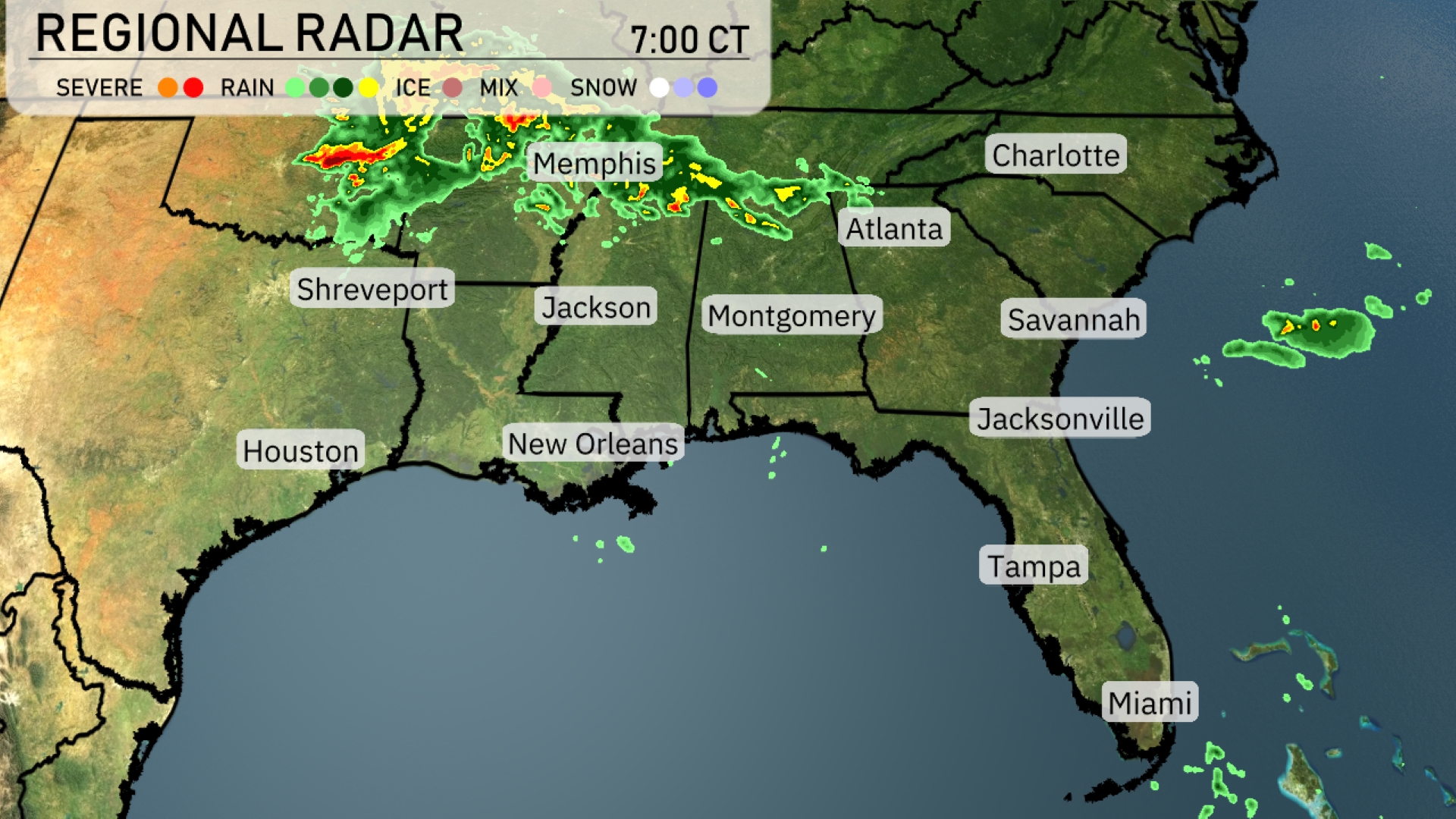
On a partly cloudy evening in Atlanta, temperatures are set to decline gracefully, maintaining a peaceful atmosphere. However, the serenity is slightly marred by looming storm threats from the nearby regions. Amy Freeze walks you through each step, ensuring you’re well-prepared for the shifts in weather. From severe storms in Memphis to calm breezes in Atlanta, find out the intricacies of these dynamic weather conditions. For deeper insights, visit our full article at https://amyfreeze.ai/. The regional radar shows an active weather pattern with storms moving through Tennessee and dipping into northern Mississippi and Arkansas. Memphis is currently experiencing severe weather conditions with frequent lightning and heavy rain. As these storms drift southeast, Jackson is on alert for incoming rainfall. Areas like Atlanta and Montgomery remain clear, but clouds are beginning to gather. Coastal cities such as Savannah and Jacksonville are presently enjoying dry conditions. For this evening in Atlanta, temperatures will gradually decrease from 75 degrees at 9 PM to 69 degrees by 1 AM. The sky will start off mostly cloudy and transition to fully cloudy as the night progresses. Winds will remain steady from the east at 4 miles per hour, keeping the evening calm. High pressure continues to hold, ensuring a dry evening. Tomorrow the Southeast is waking up to mild temperatures before things heat up. Memphis will see a low of 64 degrees, while Nashville drops to 60. Montgomery is forecasted at 70 degrees, with Jackson slightly cooler at 69. In Georgia, Atlanta will experience a low of 66, and it’s a warm 73 in both Savannah and Jacksonville. Tampa is also warm at 74 degrees, while Miami lingers at 80. The afternoon temperatures soar. Houston and Shreveport will both reach 92 degrees, while Jackson and New Orleans will also go for a warm 89 degrees. Montgomery is set for a high of 89, with Atlanta slightly cooler at 81 degrees. Coastal cities like Savannah and Jacksonville will enjoy highs of 85 and 91 degrees, respectively. Expect an active weather pattern for the Southeast tomorrow. As a cold front approaches, thunderstorms will likely develop, particularly from New Orleans to Montgomery. Be prepared for heavy downpours and possible flash flooding, especially in low-lying areas. The front reaches Atlanta by the early evening, bringing rain and stormy conditions that may cause disruptions during the evening commute. Temperatures will drop post-frontal passage, leading to cooler and more stable conditions. This Saturday in Atlanta, the UV index will be very high at 9. Expect a burn time of approximately 15 minutes with direct sun exposure—be sure to apply sunscreen and wear a hat when outdoors! By Sunday, the index slightly lowers to 6, presenting a moderate burn time of around 23 minutes. For the 7-day forecast in Atlanta:
Saturday: Showers are expected with a high of 81 degrees and a low of 63.
Sunday: Scattered thunderstorms in the forecast, reaching 81 degrees with a low of 65.
Monday: Thunderstorms continue, the temperature will climb to 83 degrees and dip to 62 at night.
Tuesday: Cooler day with rain showers, the high is expected to be around 69 degrees with a low of 61.
Wednesday: Thunderstorm chances return, and it will warm up to 81 degrees with a low near 66.
Thursday: Scattered thunderstorms likely, highs reaching 85 degrees and a low of 66.
Friday: Thunderstorms may develop early, with temperatures peaking at 79 degrees and cooling to 64 overnight.