Forecast Frenzy: Hot Days and Stormy Nights in Atlanta
By
Amy Freeze
Join us as we break down a week of fluctuating temperatures and impending thunderstorms in Atlanta and the surrounding Southeast. From heatwaves to heavy rains, here's what to expect.
This week, Atlanta anticipates varying degrees of cloud cover, searing temperatures, and potential storms. Get the details on what each day might hold in our comprehensive forecast.
As Atlanta navigates through another sultry week, here’s your comprehensive guide to the weather patterns we’re seeing across the Southeast. From clear skies to storm alerts, each day brings new developments. Whether it’s the 90-degree heat or the warning of a thunderstorm, staying informed is your best bet to planning your day wisely. Visit https://amyfreeze.ai/ for more detailed daily updates and safety tips.
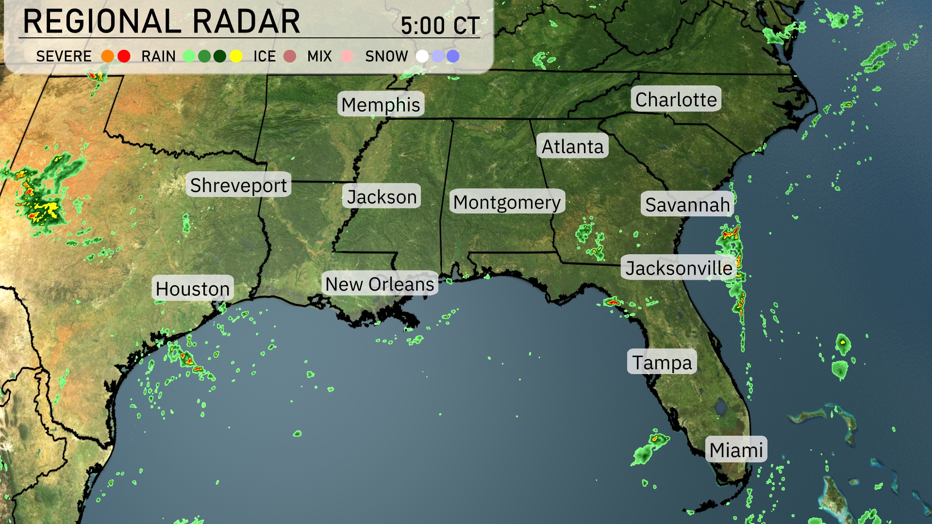
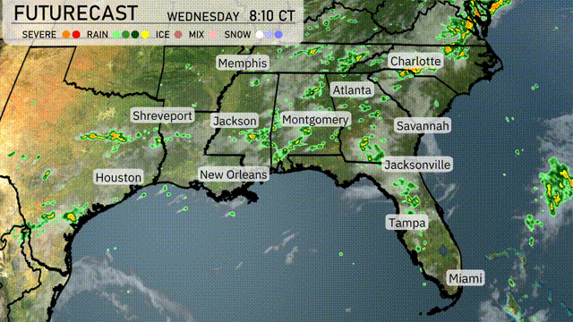
On the Regional Radar, scattered rain showers are visible off the coast of Houston, moving inland. The heavy cloud cover and rain have also moved into Jacksonville, bringing wet conditions across northern Florida. Scattered showers are present near New Orleans, but the rest of Louisiana is relatively dry. Areas around Shreveport and the central Southeast remain mostly clear, providing a break from recent precipitation.
Atlanta’s afternoon brings temperatures peaking at 90 degrees, with a west-southwest wind at 8 miles per hour giving a slight breeze. Heading into the early evening, expect the temperature to gradually drop to 88 degrees by 6 PM, with winds shifting to the west at 8 miles per hour. The skies will be mostly cloudy, providing intermittent sunbreaks while temperatures drop to 83 degrees by 8 PM.
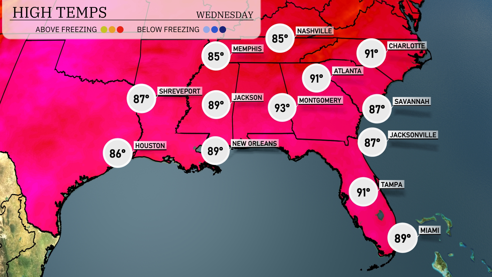
In today’s Southeast forecast, temperatures are heating up significantly. New Orleans will see a warm high of 89 degrees, while Jackson reaches 89 as well—both cities experiencing similar conditions. Montgomery is even hotter, with a high of 93 degrees, showcasing some impressive heat across Alabama. Atlanta isn’t far behind at 91 degrees, with plenty of sun and humidity in the mix. Over in Florida, Tampa will enjoy a high of 91, while Jacksonville and Savannah remain cooler at 87 degrees, benefiting from some coastal breezes.
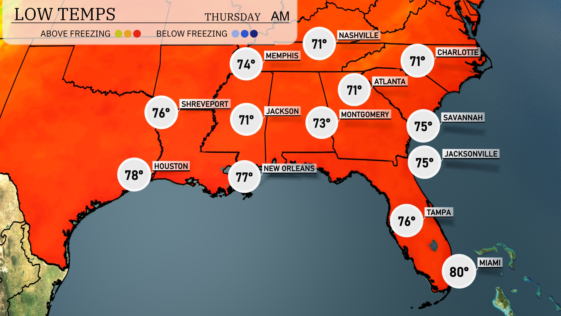
Tonight, temperatures will be quite mild across the Southeast. Memphis is expected to cool down to 74 degrees, while Nashville will see a low of 71 degrees. In New Orleans, expect a slightly warmer night at 77 degrees, with Shreveport dropping to 76. Birmingham will hit a low of 73 degrees.
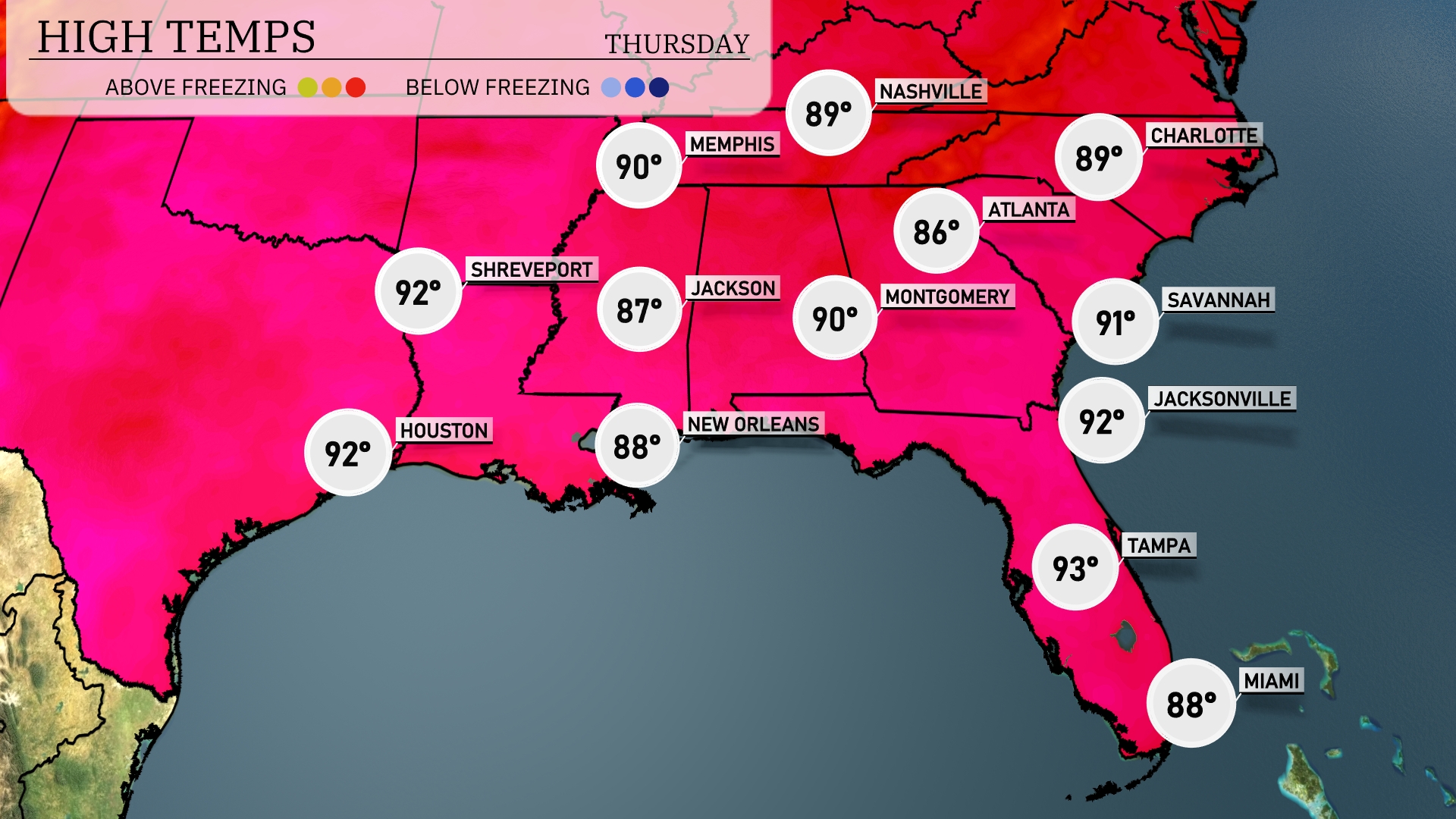
Tomorrow, highs in the Southeast are set to sizzle, with Jackson reaching 87 degrees. In Mississippi, Shreveport and New Orleans will both hit a warm 92 degrees, while Houston will match that at 92 as well. Over in Alabama, Montgomery is forecasted for a hot 90 degrees. Further to the east, Tampa will be the warmest spot at 93 degrees, with Jacksonville close behind at 92 degrees. Expect above-average temperatures across the region as warm air continues to dominate the Southeast.
Expect an active weather day across the Southeast tomorrow. A frontal system will push through the region, bringing scattered thunderstorms from New Orleans to Charlotte. These storms may deliver heavy rain and gusty winds, particularly during the morning commute in the Carolinas. Look out for showers extending from Atlanta to Jacksonville, with heavy downpours likely in localized areas. Much needed rainfall could help alleviate drought conditions, but be cautious of potential ponding on roads.
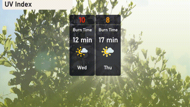
In Atlanta, expect a very high UV index of 10 today, with a burn time of just 12 minutes under direct sunlight—be sure to apply broad-spectrum sunscreen and wear a hat! Tomorrow, Thursday’s UV index is slightly lower at 8, with a burn time of 17 minutes, so continued sun protection is advised to avoid quick burns.