Storm Watch: Atlanta Braces for a Weather Whirlwind – Your Weekly Forecast
By
Amy Freeze
Atlanta's weather is taking a dramatic turn with storms approaching. Catch all the details of what to expect right from Meteorologist Amy Freeze!
Hello, Atlanta! Get ready as Amy Freeze guides you through this week’s shifting skies. From sunny afternoons to stormy evenings, here’s everything you need to know to plan your week.
With the beauty of summer comes the unpredictability of the weather. This week in Atlanta proves no different. Join Meteorologist Amy Freeze as she breaks down the weather patterns from today’s somewhat calm conditions to the looming storms. With a detailed 7-day outlook, we’re looking at temperature swings, potential severe storms, and how these conditions could impact your daily plans. Stay prepared and informed with your trusted weather forecast from Amy Freeze.
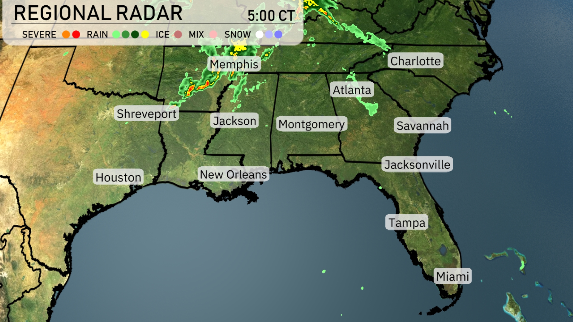
A line of storms is sweeping through the mid-South, currently affecting Memphis with severe weather marching towards the northeast. Light to moderate rain stretches from Jackson to Atlanta, while Montgomery prepares for showers moving in. New Orleans and Baton Rouge are in the clear, under mostly cloudy skies. Jacksonville and the surrounding coastal regions, including Savannah, are enjoying dry conditions for now. Farther south, Miami is basking in fair weather.
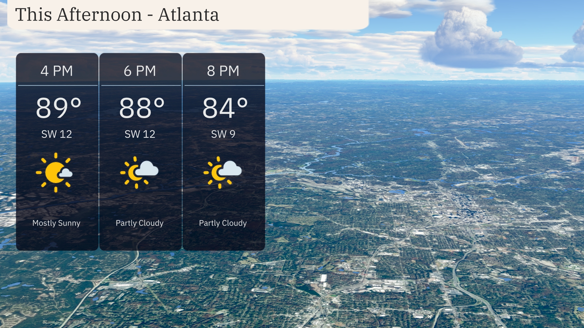
Atlanta temperatures through the afternoon are soaring into the upper 80s, peaking at 89 degrees under a mostly sunny sky. Winds are from the southwest at 12 miles per hour, offering a gentle breeze. Cloud cover increases slightly as we move into the evening, with temperatures cooling to 84 degrees by 8 PM.
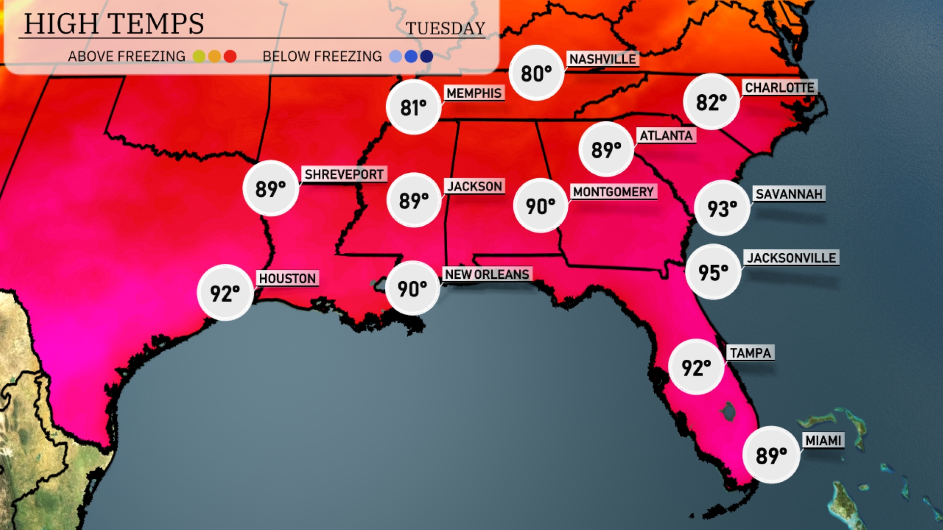
Afternoon high temperatures in the Southeast are soaring today. In Jacksonville, the forecast shows a peak at a steamy 95 degrees, while Savannah isn’t far behind at 93. Montgomery will experience a warm day, reaching 90 degrees, and New Orleans also sits at 90. Further west, Houston is expected to hit 92 degrees. Atlanta remains slightly cooler with a high of 89, and Jackson will also see a warm afternoon at 89 degrees.
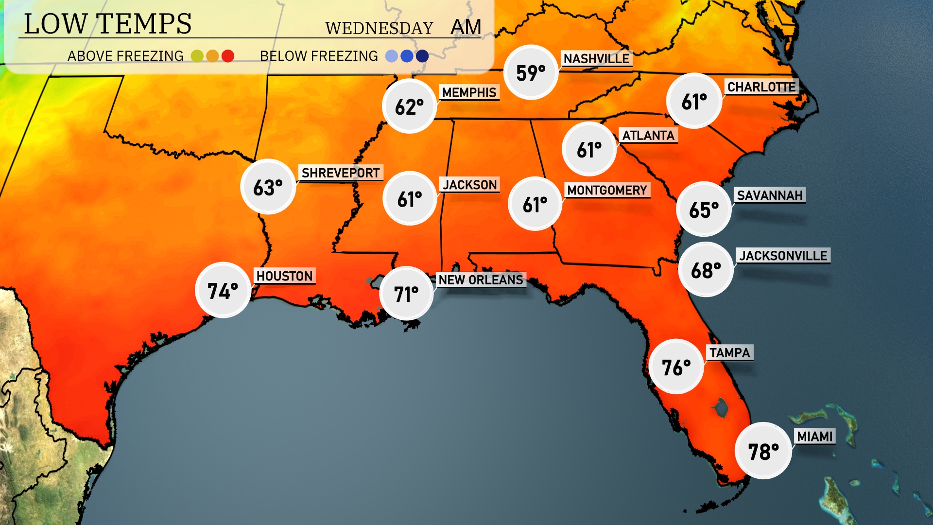
Tonight in the Southeast, temperatures will dip into the upper 50s and low 60s. Nashville is expected to cool down to 59 degrees, while Memphis will also see a low of 62. Areas like Montgomery and Jackson will hold steady at 61 degrees. In contrast, further south, New Orleans will stay milder at 71 degrees, but staring at a low of 74 in Houston. Expect a bit more warmth in the Florida region with lows around 76 in Tampa and 78 in Miami.
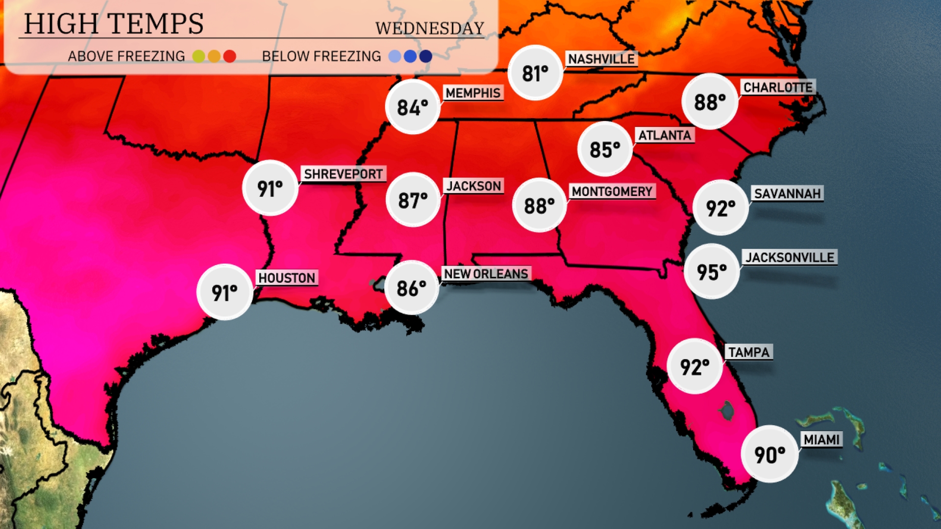
High temperatures throughout the Southeast tomorrow are expected to soar above average as warm air continues to dominate the region. Atlanta will see a high of 88 degrees, while Montgomery reaches 88 as well. Jacksonville is projected to hit a sweltering 95 degrees, with Savannah not far behind at 92. In New Orleans, anticipate highs around 86 degrees, and Houston will feel the heat at 91.
A cold front brings widespread showers and thunderstorms to the Southeast tomorrow, impacting areas from Houston to Atlanta. Expect heavy downpours, especially around New Orleans and Montgomery, with a possibility of strong winds and isolated severe storms. Rain will extend into the Carolinas, affecting morning commutes. As the system progresses, watch for gusty conditions and potential flash flooding, particularly in low-lying areas. Cool, dry air follows the front, bringing relief from recent humidity and clearing conditions by late Wednesday.
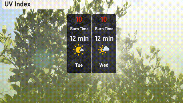
The UV index in Atlanta will be very high on both Tuesday and Wednesday with a value of 10, suggesting a burn time of just 12 minutes in direct sunlight.