Meteorologist Amy Freeze gives you the latest scoop on Atlanta's fluctuating weather patterns, from tranquil evenings to boisterous storm fronts moving in.
Catch exclusive insights on Atlanta’s weather with updates on temperatures, storms, and more, ensuring you’re prepared whatever the weather!
Stay tuned with Meteorologist Amy Freeze as we navigate through Atlanta’s varied climate from serene nights to vigorous storms sweeping across the Southeast. This comprehensive guide covers the latest on temperature shifts, the 7-day weather outlook, and severe weather warnings to keep you informed and ready.
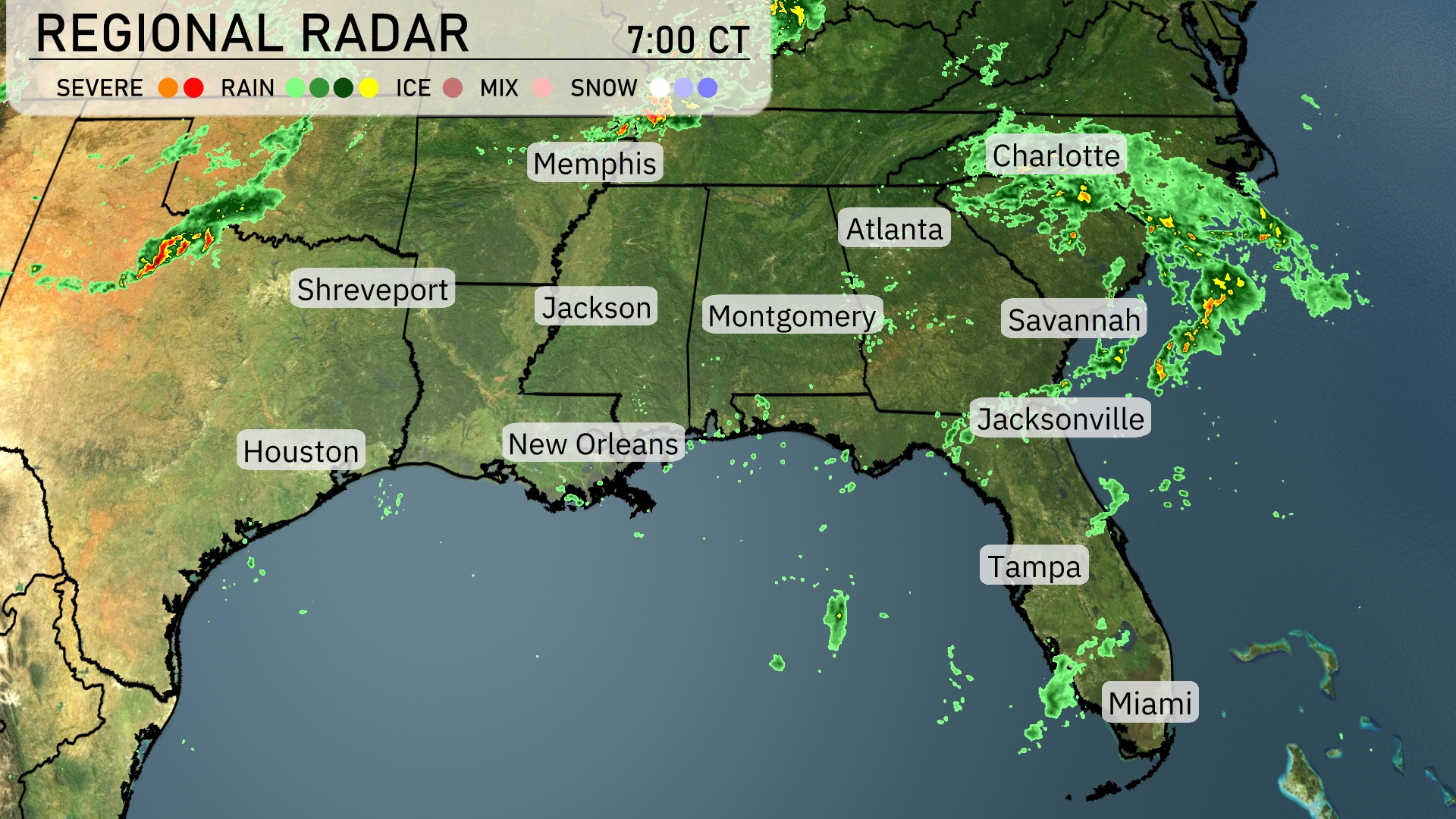
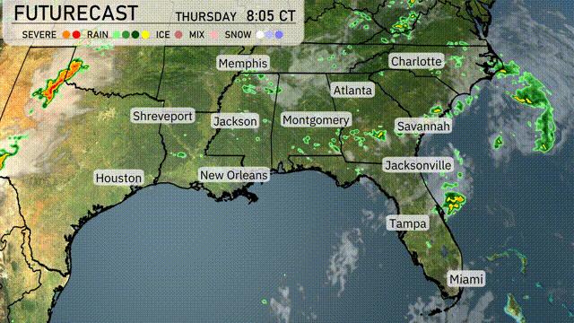
On the Regional Radar, a line of rain showers is sweeping eastward, moving towards the Carolinas. The strongest precipitation is currently affecting Savannah and Jacksonville, with heavy rain advancing toward Charlotte and Atlanta. Clouds and light rain are also approaching Montgomery from the west. Shreveport is dealing with some rain as showers in Texas move closer. Most of the Gulf Coast, including areas like Miami and Tampa, enjoys drier conditions for now.
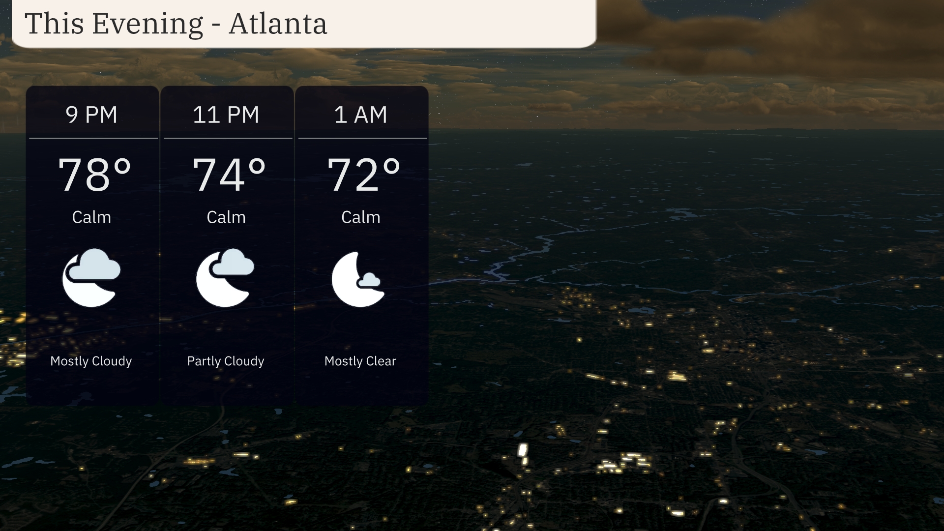
For this evening in Atlanta, temperatures gradually decrease from 78 degrees at 9 PM to 72 degrees by 1 AM. The skies transition from mostly cloudy to mostly clear as the night progresses.
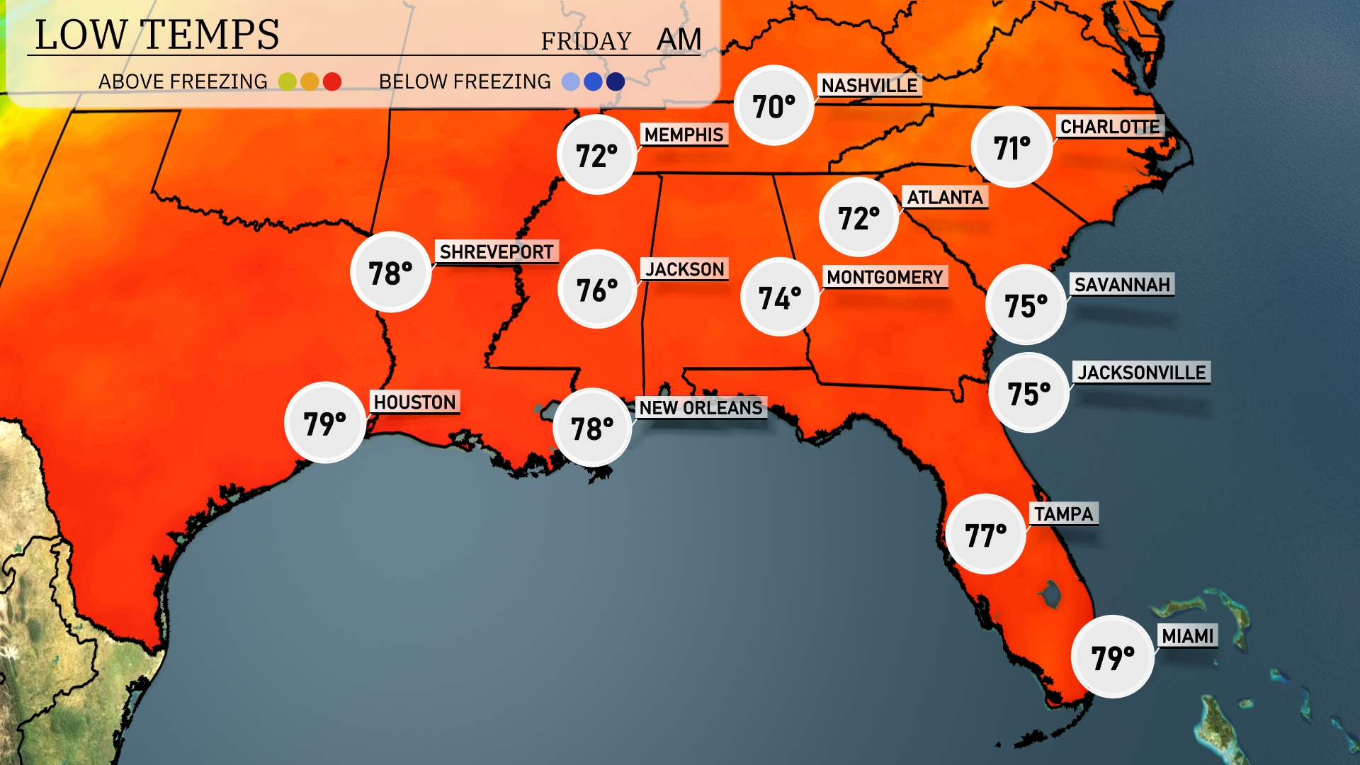
Tonight, expect mild temperatures across the Southeast. Memphis will drop to 70 degrees, while Nashville cools down to 72. Shreveport will see a low of 78, and Jackson is expected to rest at 76 degrees. Atlanta will have a low of 72, with Montgomery slightly cooler at 74. The hottest spots will be in Florida, where both Tampa and Miami hover around 77 and 79 degrees, respectively.
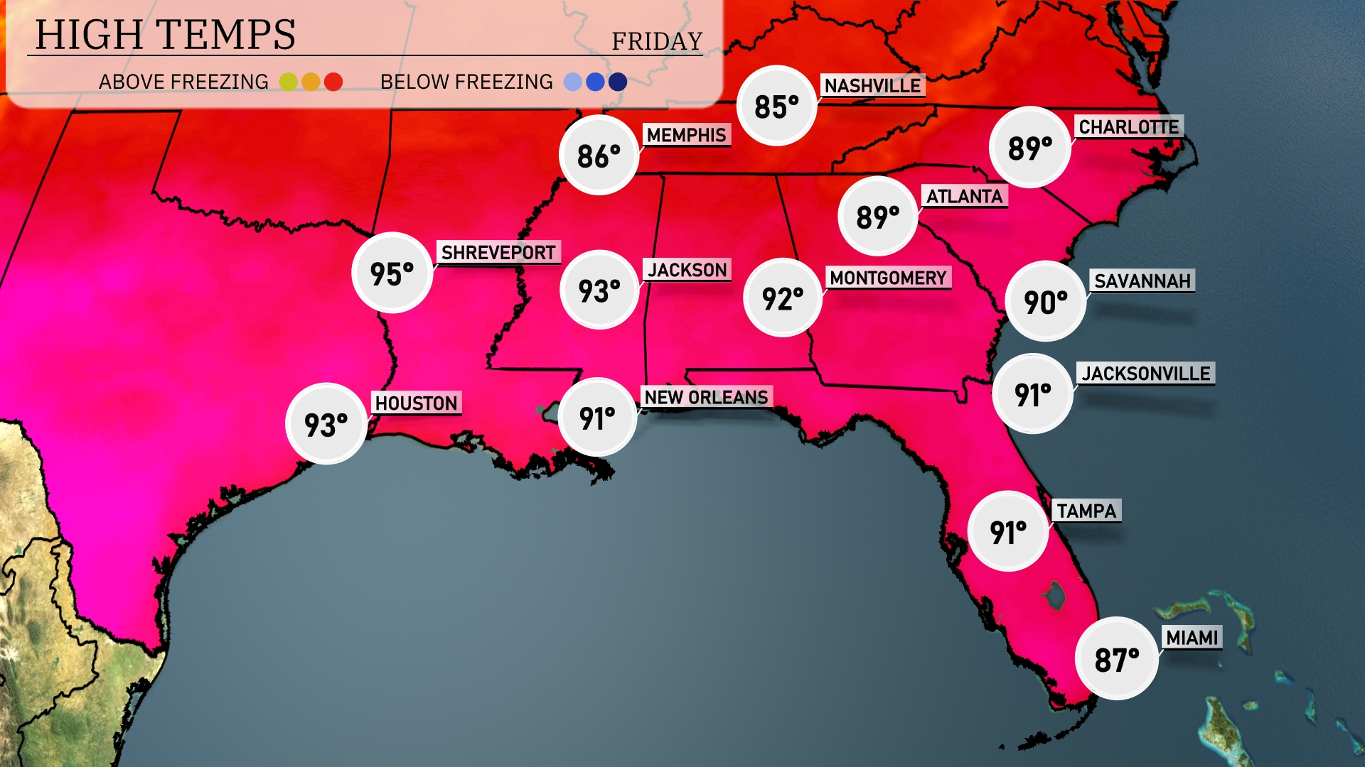
Tomorrow in the Southeast, expect high temperatures to soar across the region. Atlanta will reach a warm 89 degrees, while Montgomery tops out at 92. Farther south, temperatures in Jacksonville and Savannah will hit 91 and 90 respectively. New Orleans will see a high of 91 degrees, and over in Houston, anticipate a warm 93. Shreveport remains the hottest spot of the day at 95 degrees.
An active weather day is ahead for the Southeast region, with scattered thunderstorms developing from Jackson to Atlanta as a cold front approaches. Areas like New Orleans and Memphis may see intense downpours and gusty winds, especially in the afternoon. Isolated severe weather, including the risk of damaging winds, is possible as the front moves eastward. Temperatures will remain rather warm but expect cooler air to filter in behind the front by Thursday night, bringing a refreshing change just in time for the weekend.
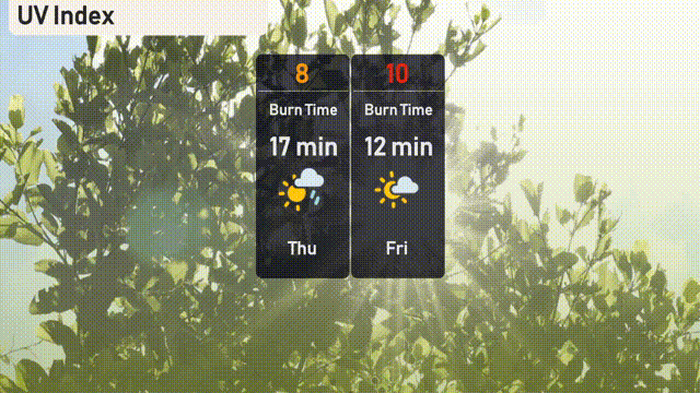
The UV index in Atlanta will be very high on Thursday with a value of 8, suggesting a burn time of about 17 minutes in direct sunlight. By Friday, the index peaks to an extreme level of 10, with a burn time of just 12 minutes!
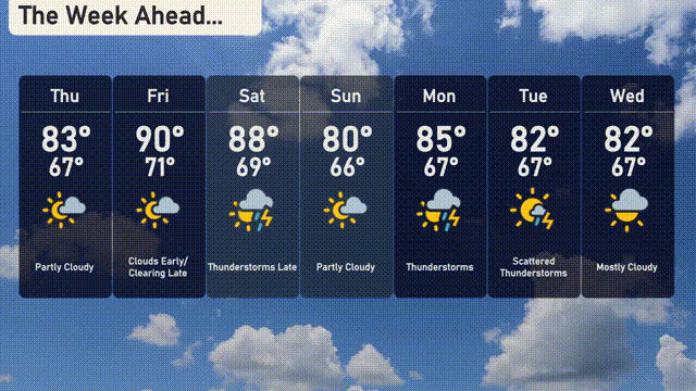
For the 7 Day Outlook in Atlanta:
Thursday: Partly cloudy skies with a warm high of 83 degrees and a low of 67.
Friday: Clouds hanging around early, clearing late, reaching a high of 90 degrees with a low of 71.
Saturday: Thunderstorms moving in with a daytime high of 88 degrees and cooling down to 69 at night.
Sunday: A bit calmer with partly cloudy conditions, temperatures rise to 80 degrees during the day, dropping to 66 at night.
Monday: Thunderstorms return with a high of 85 degrees and a low of 67.
Tuesday: Scattered thunderstorms throughout the day with the mercury hitting 82 degrees and a low of 67.
Wednesday: The week wraps up with mostly cloudy skies, a high of 82 degrees, and a low of 67.