Clouds on the Horizon: Atlanta’s Weather Forecast Unveiled
By
Amy Freeze
Dive deep into Atlanta's week ahead with Amy Freeze's detailed weather insights. From temperate evenings to stormy forecasts, know what each day holds.
Amy Freeze provides a concise overview of the weather trends in Atlanta and the Southeast, highlighting the shifts from calm skies to stormy evenings.
Get an in-depth look at the week’s weather for Atlanta and the Southeast with expert insights from Meteorologist Amy Freeze. From heat waves across the region to the anticipation of heavy storms, Amy provides detailed predictions and precautions for the upcoming days.
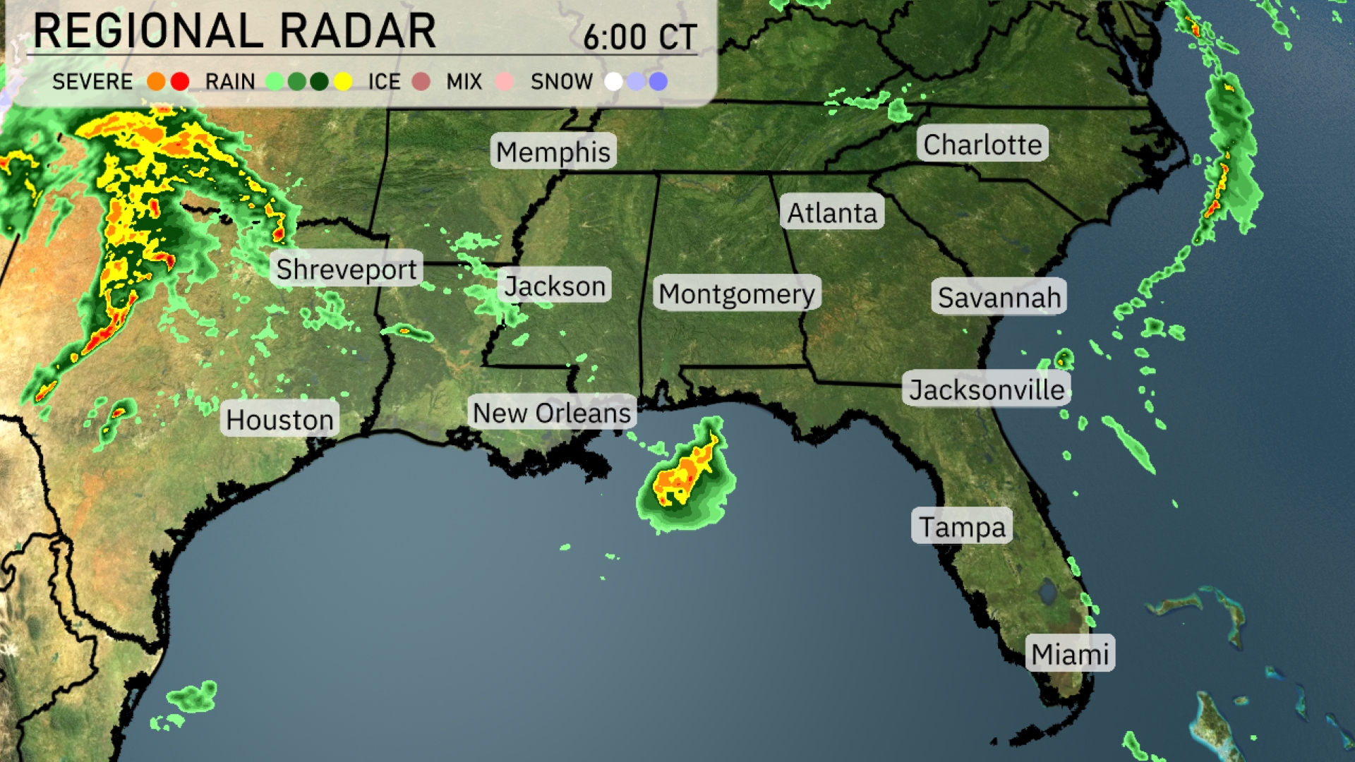
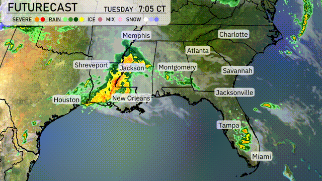
The Southeast is mostly calm, but rain showers are developing near New Orleans and starting to move inland. A significant storm system bringing heavy rain is approaching from the west, moving towards Shreveport and Jackson. Houston, although currently dry, is on track to experience some rain soon. Montgomery and Atlanta are seeing increasing cloud cover as the weather system progresses. Coastal cities like Tampa and Miami are enjoying clear conditions for now, perfect for outdoor plans.
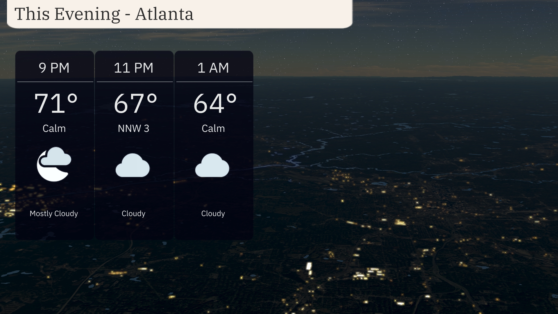
For this evening in Atlanta, begin with mostly cloudy skies at 9 PM with a temperature of 71 degrees. By 11 PM, expect clouds to persist as temperatures slip to 67 degrees, with a gentle north-northwest breeze at 3 miles per hour. As we move into the early hours, skies remain cloudy, cooling to 64 degrees by 1 AM.
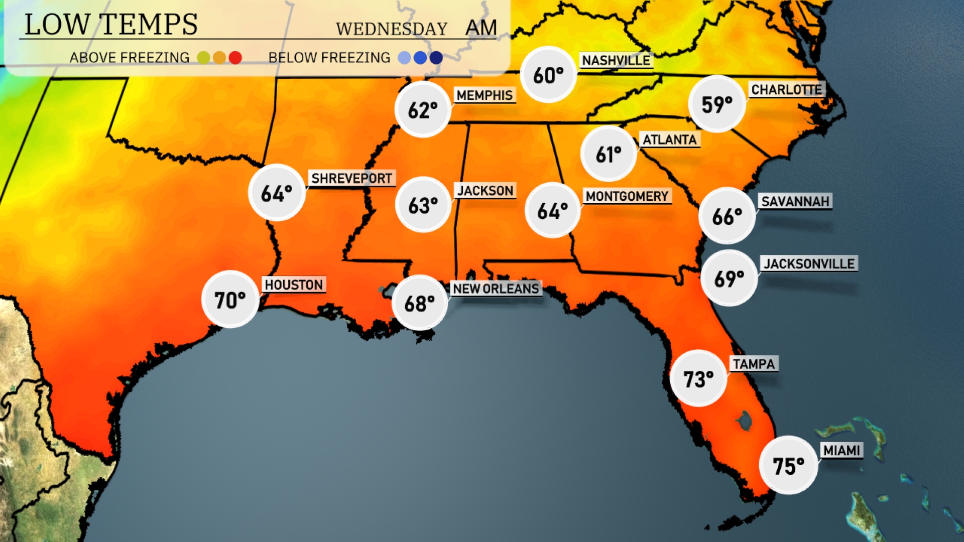
The Southeast is in for a cooler night, with lows dropping significantly across the region. Expect 60 degrees in Memphis and Nashville, marking a clear chilly change. Montgomery is forecasted to cool down to 64 degrees, while Jackson will see a low of 63. Atlanta will register a brisk 61 degrees, and farther south in Jacksonville, temperatures will dip to 69. Cities like Tampa and Miami will remain mild, with lows of 73 and 75, respectively.
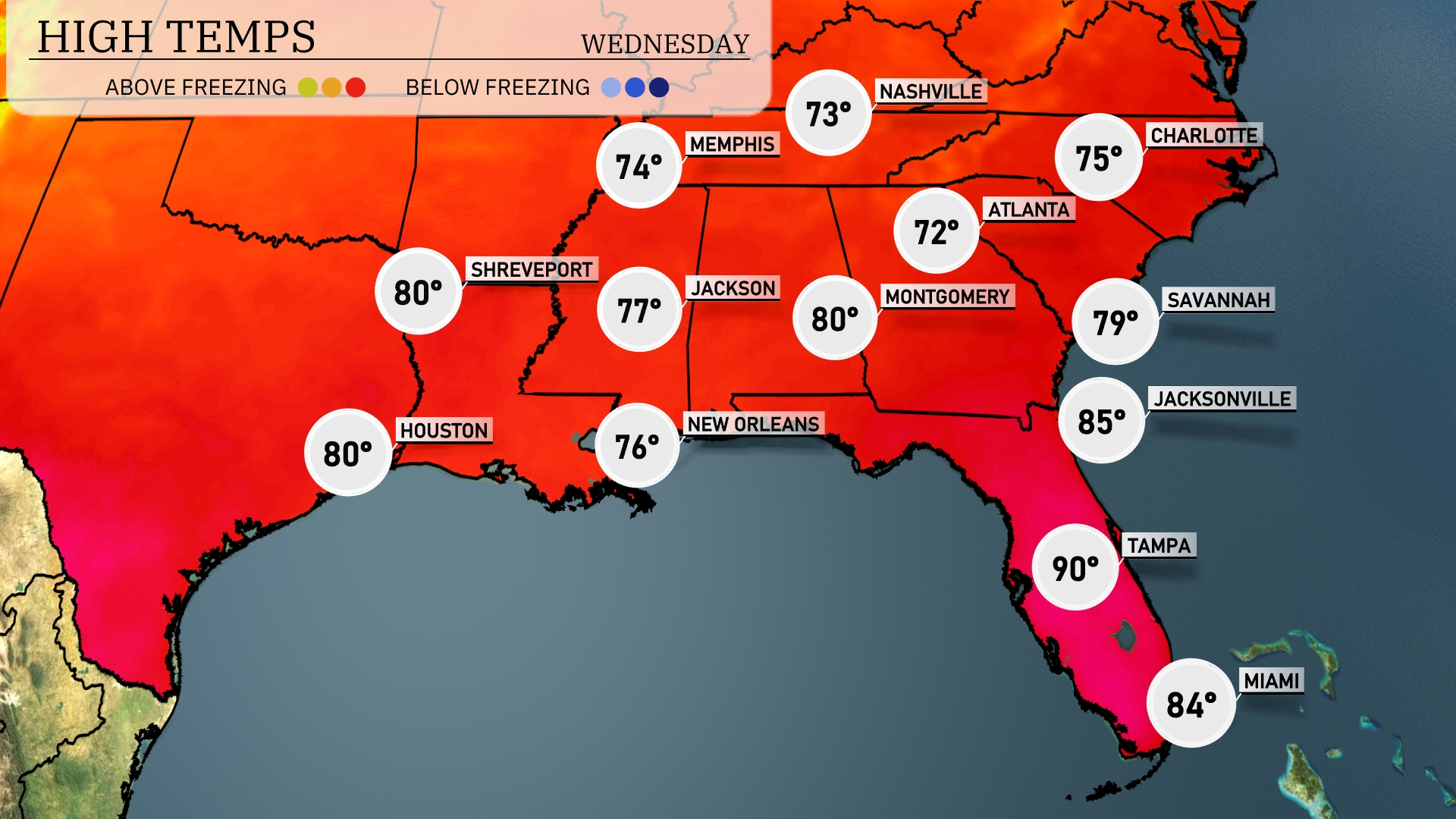
For tomorrow, the Southeast is gearing up for a warm day with temperatures well above average in many areas. Atlanta will see a high of 72 degrees, while Montgomery reaches 80 degrees. Jacksonville will be quite warm at 85 degrees, and Tampa peaks at a sizzling 90 degrees. New Orleans stays comfortable at a high of 76 degrees, with similar readings expected in Houston.
An active weather pattern is on the horizon for the Southeast as a cold front pushes through the region from Louisiana to Georgia. Heavy thunderstorms are anticipated from Shreveport to Atlanta, with potential for localized flooding due to intense downpours. By Tuesday evening, expect scattered storms across Jackson and into Montgomery, with rainfall also affecting the coastal areas from New Orleans to Jacksonville. Temperatures will dip slightly behind the front, with cool conditions expected by Wednesday.
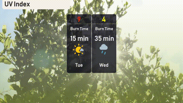
The UV index in Atlanta is set to be very high at 9 on Tuesday, indicating a burn time of just 15 minutes in direct sunlight. On Wednesday, the index will drop to 4 due to cloud cover, which means a moderate exposure level with a 35-minute burn time.
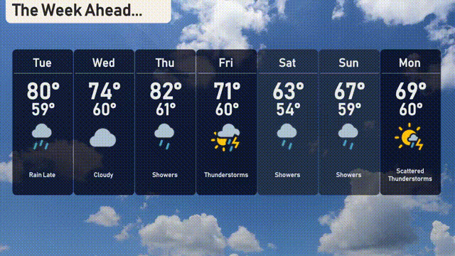
For the 7 Day Outlook in Atlanta:
Tuesday: Rain is expected later in the day, with a high of 80 degrees and a low of 59.
Wednesday: Cloudy skies throughout, with temperatures reaching 74 degrees and dropping to 60 at night.
Thursday: Prepare for showers, as the temperature peaks at 82 degrees and falls to 61 overnight.
Friday: Thunderstorms are likely, with a daytime high of 71 degrees and a night low of 60.
Saturday: Temperatures will cool to a high of 63 degrees with a low of 54, under cloudy skies with some sun.
Sunday: Expect more showers, as temperatures climb to 67 degrees, cooling to 59 by night.
Monday: Scattered thunderstorms are possible, with a daytime high of 69 degrees and a nighttime low of 60.