Explore what the weather in Atlanta and the Southeast region holds this week, from thunderstorms to soaring temperatures.
This week, Atlanta and the Southeast face a mix of thunderstorms and fierce heat. Get the scoop on what to expect and how to stay safe!
As we dive deeper into the heart of summer, Atlanta and its surrounding areas are experiencing a dynamic mix of weather conditions. From intense heat waves peaking at nearly 100 degrees to sudden, potentially severe thunderstorms, here’s everything you need to stay informed and prepared. Amidst these conditions, remember to protect yourself from high UV levels. Follow our daily and weekly forecasts for the latest trends and safety tips.
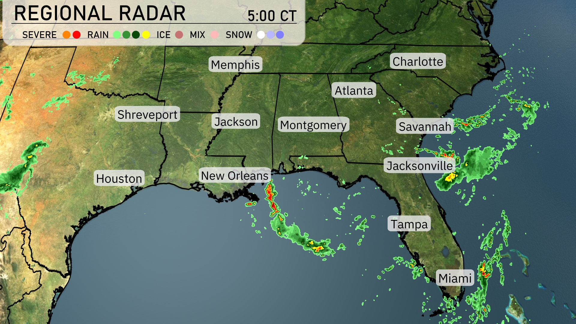
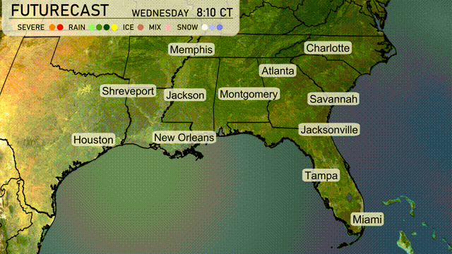
A distinctive band of thunderstorms is stretching from New Orleans eastward along the Gulf Coast, impacting areas like Mobile with heavy rain. Jacksonville is currently experiencing scattered rain showers, while precipitation is tapering off as you head further north past Savannah. Meanwhile, there are clearer skies over Atlanta and Charlotte, indicating calmer weather. Elsewhere, light showers are making their way across central Florida, potentially affecting Tampa and Orlando.
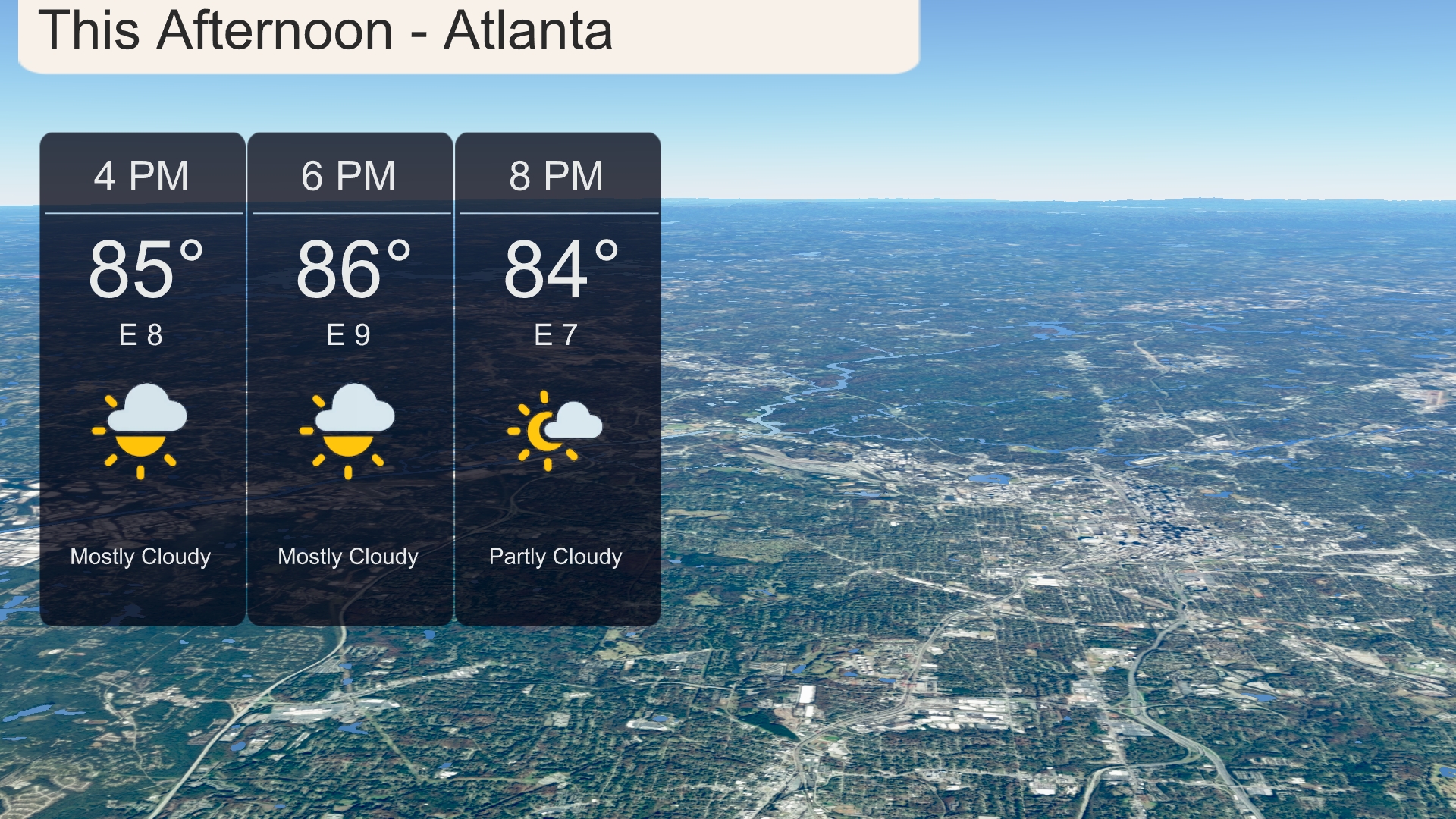
This afternoon in Atlanta, temperatures will rise to around 86 degrees by 6 PM, with a mostly cloudy sky. Winds will be coming from the east at speeds ranging from 8 to 9 miles per hour. As the evening approaches, expect temperatures to settle at 84 degrees with partly cloudy conditions. Keep an eye on the sky if you’re planning any outdoor activities.
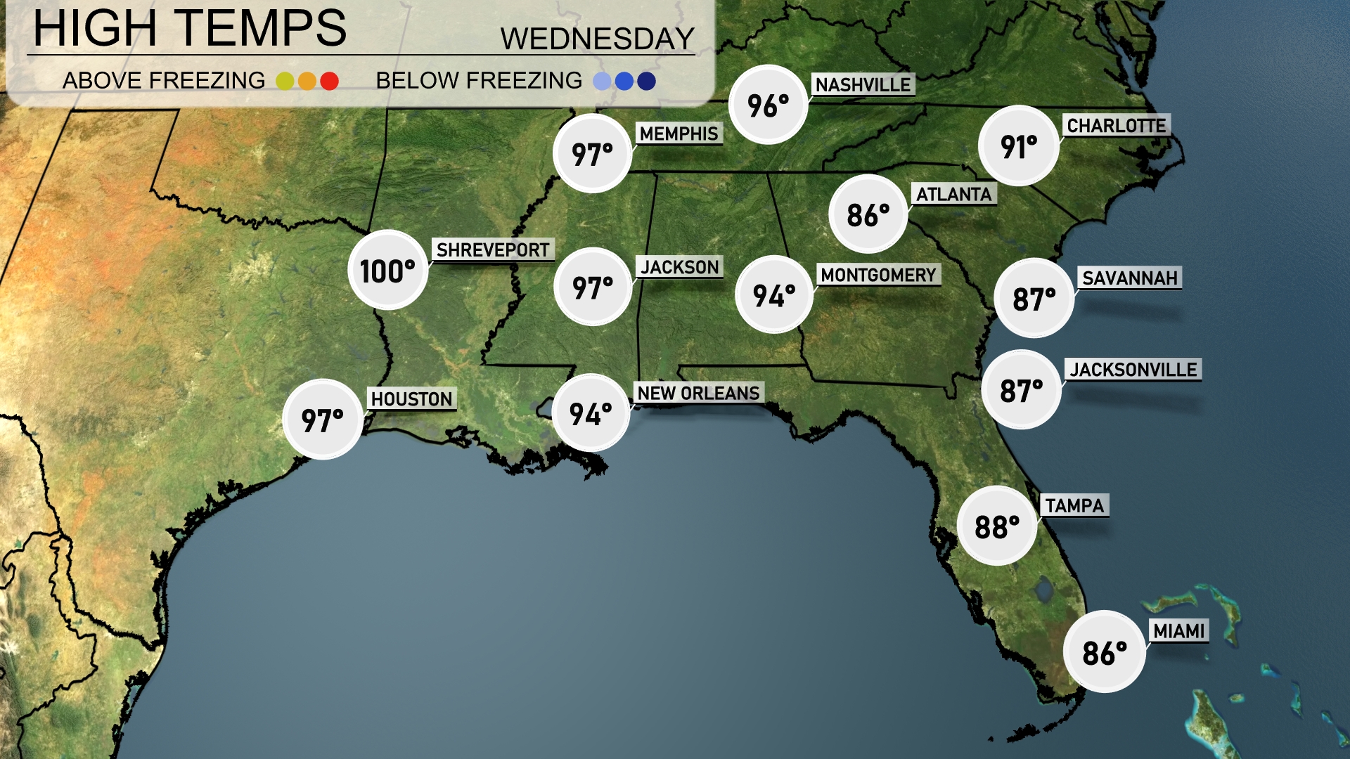
Today’s high temperatures in the Southeast are bringing the heat. Shreveport is sizzling with a high of 100 degrees, while Jackson is not far behind at 97. New Orleans and Montgomery will see a warm day as well, both peaking at 94 degrees. Over in Florida, Tampa will reach 88, whereas Jacksonville and Savannah will remain cooler at 87 degrees. Expect a mix of sunshine and higher humidity across the region, leading to that summer feel we all know too well.
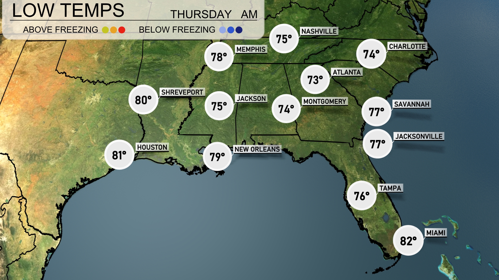
Tonight, Memphis will see lows around 75 degrees, while Nashville dips slightly to 73. In the deep South, New Orleans is expected to drop to 79 degrees, and Jackson will experience a low of 75. Meanwhile, Tampa will remain mild at 76, with Jacksonville and Savannah both maintaining a warm 77 degrees overnight.
Tomorrow in the Southeast, temperatures are on the rise with some areas hitting notable highs. Atlanta is expected to warm up to 90 degrees, while Charlotte will see a high of 92. Further south, Jacksonville and Savannah will reach 91 and 90 degrees, respectively, indicating an above-average trend as we enter late July. New Orleans will be slightly cooler at 87 degrees, but still warm for this time of year. In the western part of the region, Shreveport could hit 100 degrees, showcasing the intense heat gripping parts of the Southeast.
A cold front sweeps across the Southeast, bringing thunderstorms that could pack a punch from Houston to Atlanta, starting Wednesday morning. By the afternoon, scattered storms will extend eastward to Jacksonville and northward to Charlotte. Expect potential heavy rain, capable of localized flooding, especially in low-lying areas. Winds may gust upwards of 40 mph, so secure outdoor items. As the front passes, cooler, calmer conditions will set in by late Thursday, with temperatures dropping a few degrees across the region.
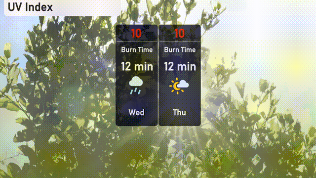
The UV index in Atlanta for Wednesday and Thursday will be extreme at 10, with potential sun exposure risks within just 12 minutes, necessitating effective sun protection measures. Ensure to seek shade, apply high-SPF sunscreen generously, and wear hats and sunglasses if you’re spending time outdoors. Storms are not expected to significantly reduce UV exposure, so plan accordingly for any outdoor activities!