Atlanta’s Weather Outlook: Sunshine to Storms—A Week of Contrasts
By
Amy Freeze
Explore a detailed weekly weather forecast for Atlanta with meteorologist Amy Freeze. From balmy afternoons to stormy nights, know what’s ahead.
Meteorologist Amy Freeze provides an insightful forecast for Atlanta. With temperatures rising and storms approaching, here’s everything you need to know for the upcoming week!
Welcome to your detailed weekly forecast for Atlanta! Meteorologist Amy Freeze here to guide you through varying weather conditions from warm sunny days to upcoming storm threats. Expect a mix of partly sunny skies and isolated showers, with temperatures peaking and dipping throughout the week. Stay prepared as we anticipate scattered thunderstorms influenced by a moving cold front, especially towards the weekend. Detailed predictions and safety tips included!
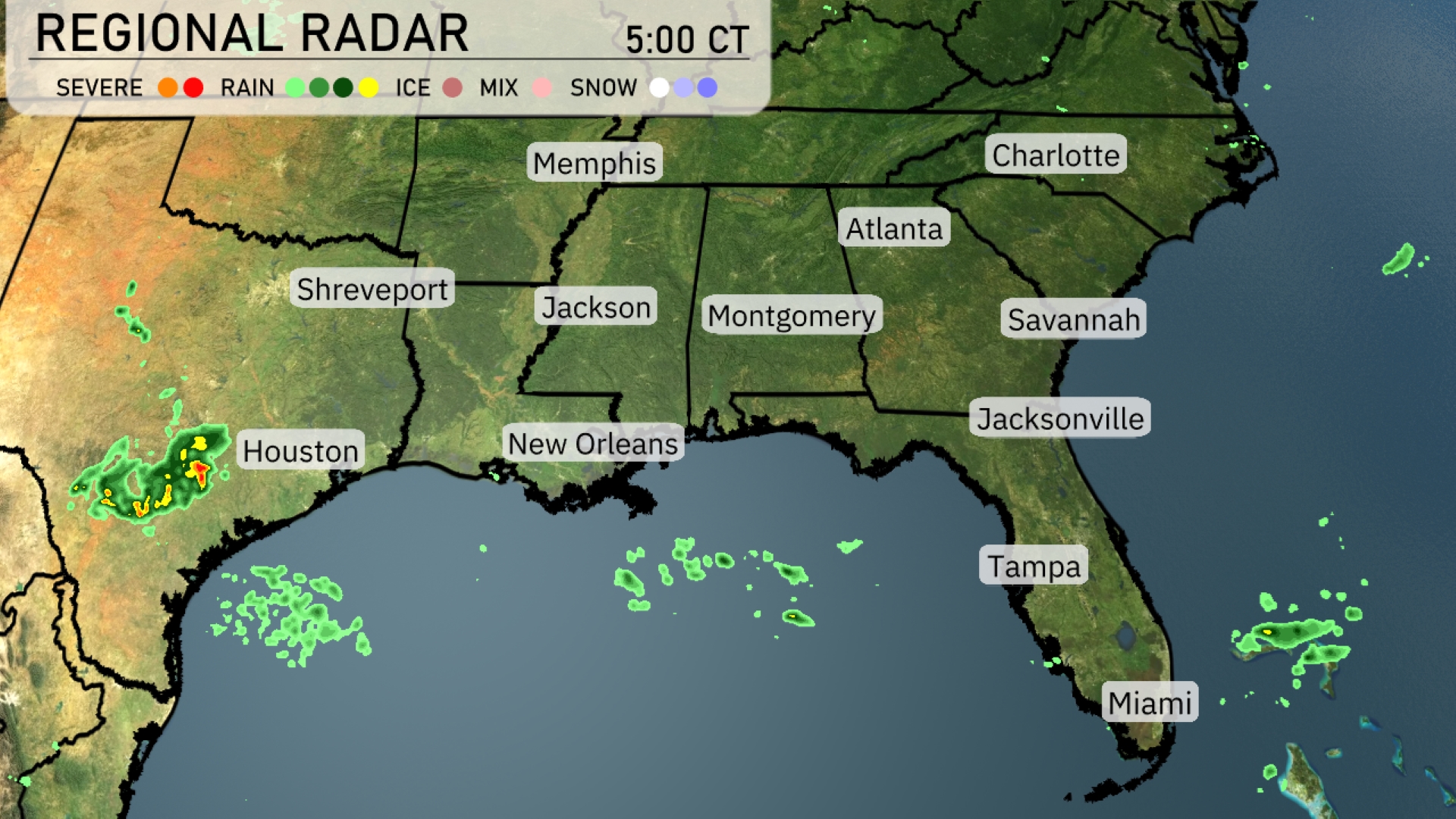
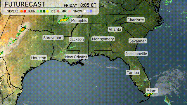
Currently, the Southeast region is experiencing isolated showers, particularly affecting coastal areas near New Orleans with more rain developing southwest of Houston. These bands of showers are moving eastward, potentially reaching coastal Mississippi and Alabama later. Clear skies prevail across central Georgia and most of the Carolinas, providing a pleasant reprieve. Montgomery to Jacksonville is also enjoying dry conditions under mostly clear skies. Charlotte and Memphis are clear too.
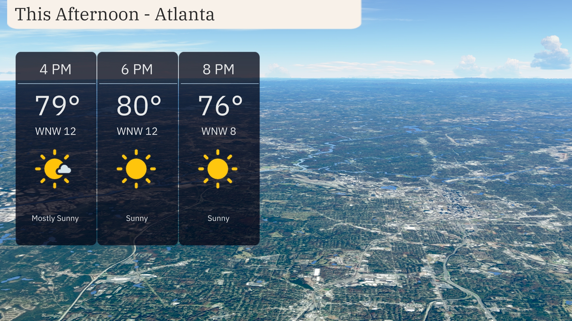
Temperatures in Atlanta this afternoon will rise to 80 degrees by 6 PM, with mostly sunny skies. Expect a gentle breeze from the west-northwest at around 12 miles per hour, providing a comfortable outdoor atmosphere. By 8 PM, temperatures will slightly decrease to 76 degrees as the sun continues shining, bringing a pleasant end to the afternoon.
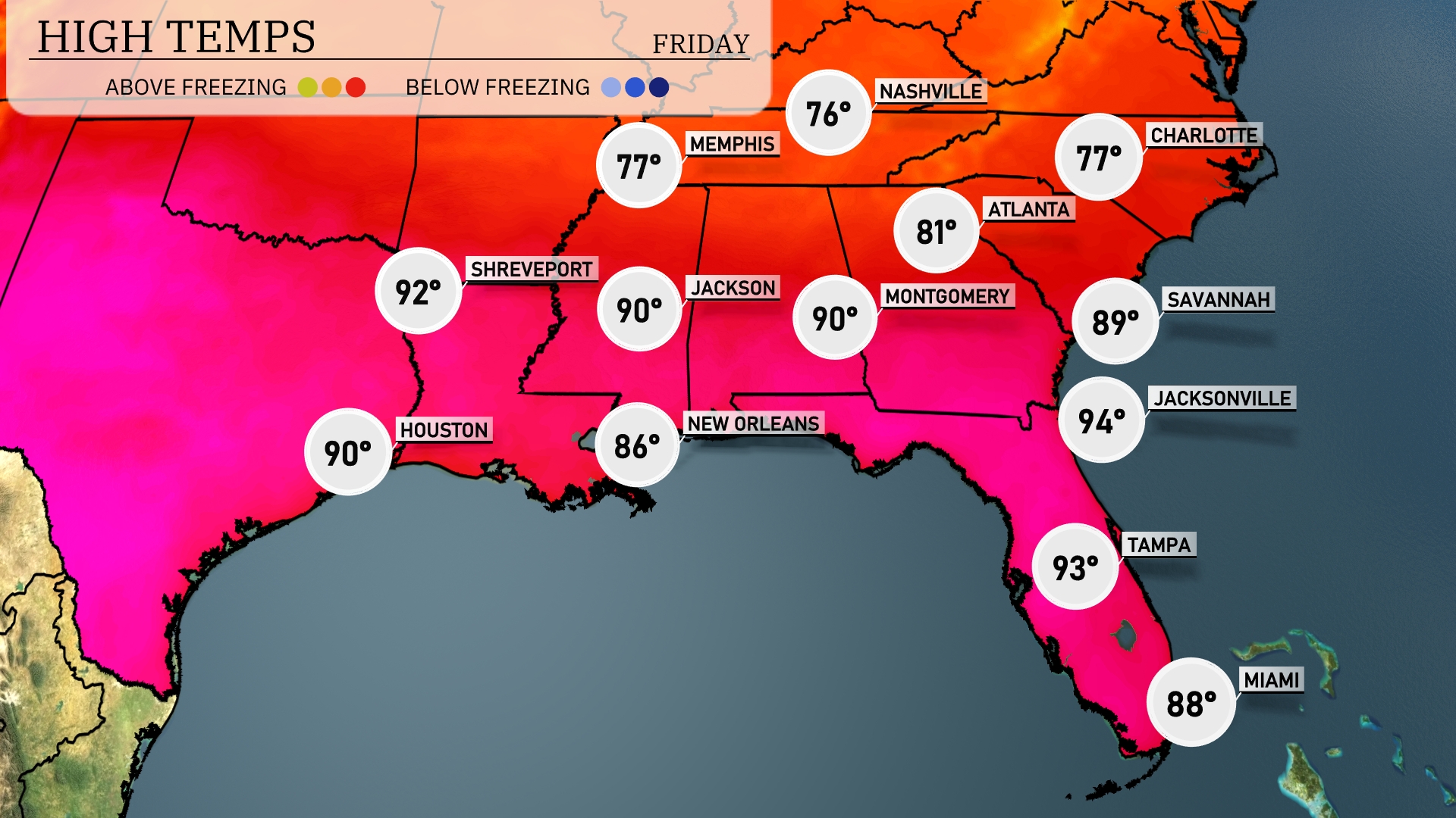
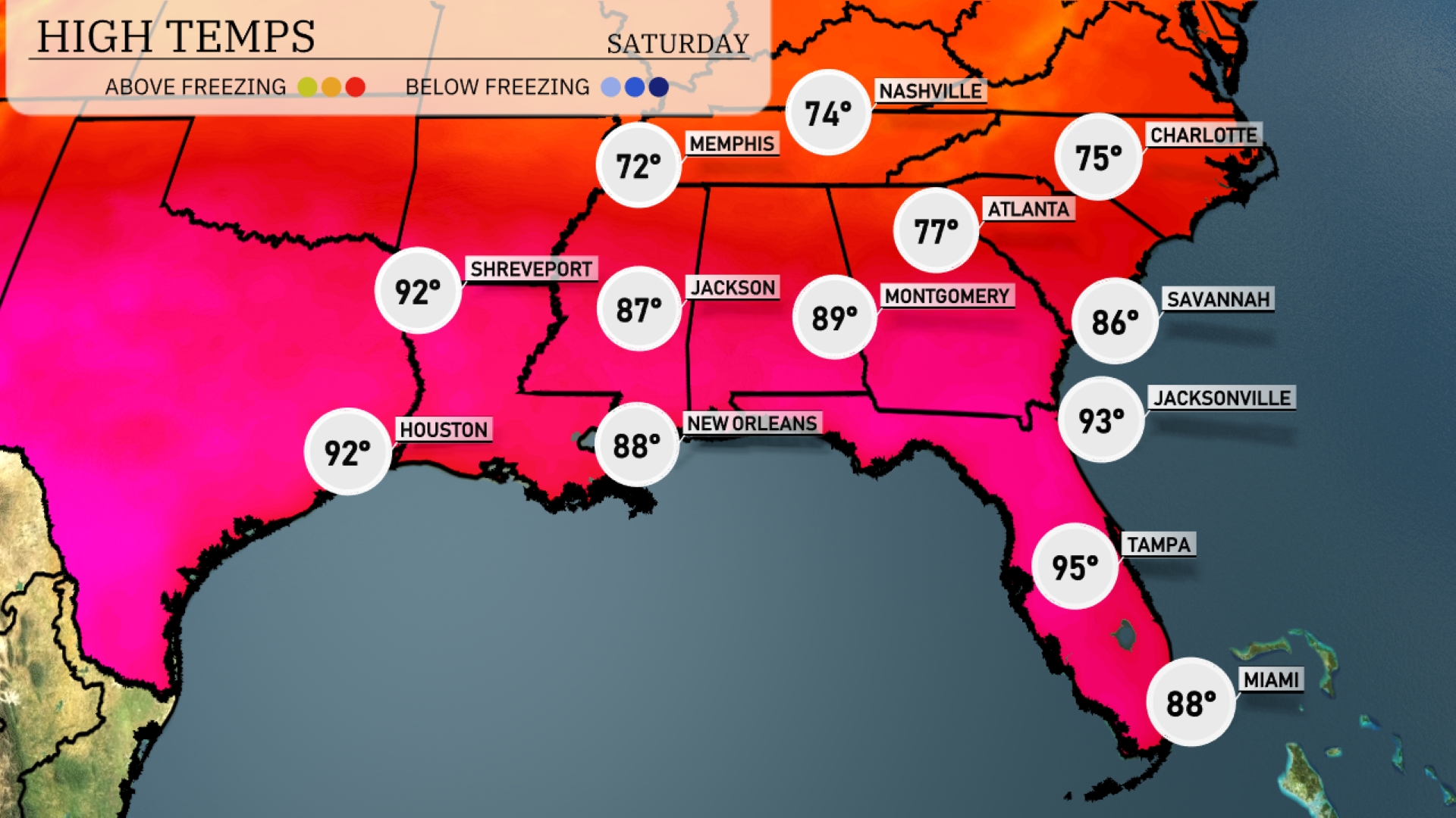
Today in Jacksonville, expect a high of 94 degrees, making it one of the hottest spots in the region. Tampa isn’t far behind with a high of 93, while Miami reaches 88 degrees this afternoon. New Orleans will see a comfortable 86 degrees, while Jackson and Montgomery both hit 90. Further north in Nashville, the temperatures are significantly cooler with a high of 76 degrees, showcasing a notable contrast.
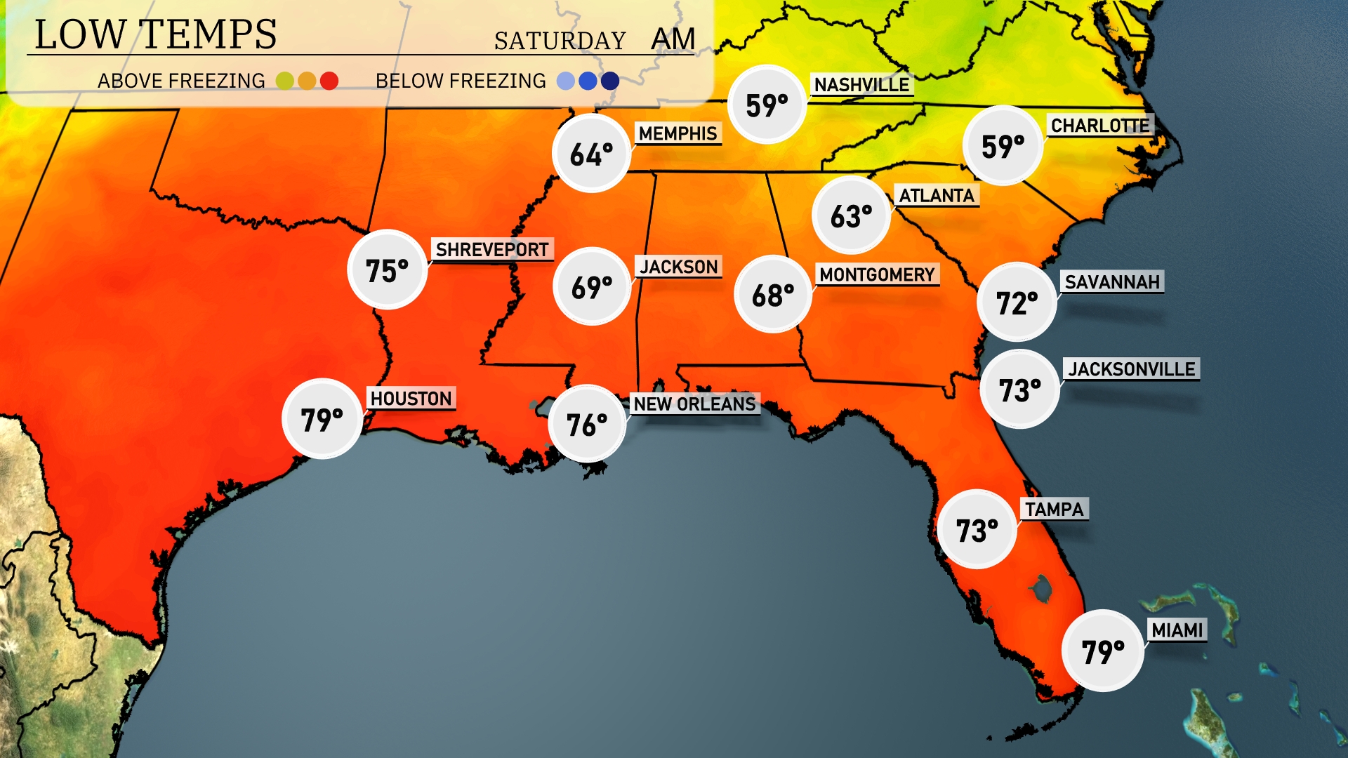
Tonight Nashville will drop to a brisk 59 degrees, while Atlanta cools down to 63. Montgomery is looking at a low of 68, with Jackson slightly cooler at 69. Savannah will be mild at 72 degrees, and both Jacksonville and Tampa will see lows of 73. New Orleans rounds out the region with a warmer low of 76 degrees.
Tomorrow Atlanta will reach 77 degrees, while Savannah pushes up to 86. Jacksonville is expecting a hot 93 degrees, and Tampa is poised for a scorching high of 95. New Orleans will see a pleasant 88 degrees, and Jackson hits 87.
A cold front will sweep across the Southeast, bringing scattered thunderstorms starting from Louisiana and Mississippi, moving eastward through Friday afternoon. Expect the heaviest rain from New Orleans to Atlanta, with strong winds and localized flooding possible in these areas. By Friday evening, the line of storms will reach Jacksonville and Tampa, intensifying overnight with potential severe weather. Cooler and clearer conditions will follow the system as it passes, bringing a respite from the humidity. Be weather alert, especially in central areas like Montgomery and Atlanta, where severe weather risks are elevated during the peak storm period.
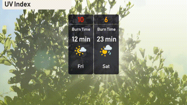
The UV index in Atlanta is quite high at 10 today, with a burn time of just 12 minutes. By tomorrow, the UV index remains elevated at 6, with a burn time of 23 minutes, although passing clouds and potential showers may offer some relief.