Atlanta’s Weather Outlook: A Mix of Thunderstorms and Sunshine Ahead
By
Amy Freeze
Explore the upcoming weather trends in Atlanta, featuring thunderstorms, clear skies, and essential safety precautions for the week.
This week in Atlanta, expect a roller coaster of weather conditions from thunderstorms to sunny days. Get the full forecast and safety tips to navigate through the week confidently.
In this detailed analysis, we explore the nuanced weather patterns over Atlanta, encompassing a blend of thunderstorms and sunny spells throughout the week. Understand the implications of thunderstorms early in the week with possible localized flooding, followed by a gradual clearing up leading to mostly clear skies. The city is set to experience fluctuating temperatures, staying in the upper 80s. Dive deeper into the reasons behind these patterns, the impact of a cold front moving in, and how you can stay prepared with safety measures and more.
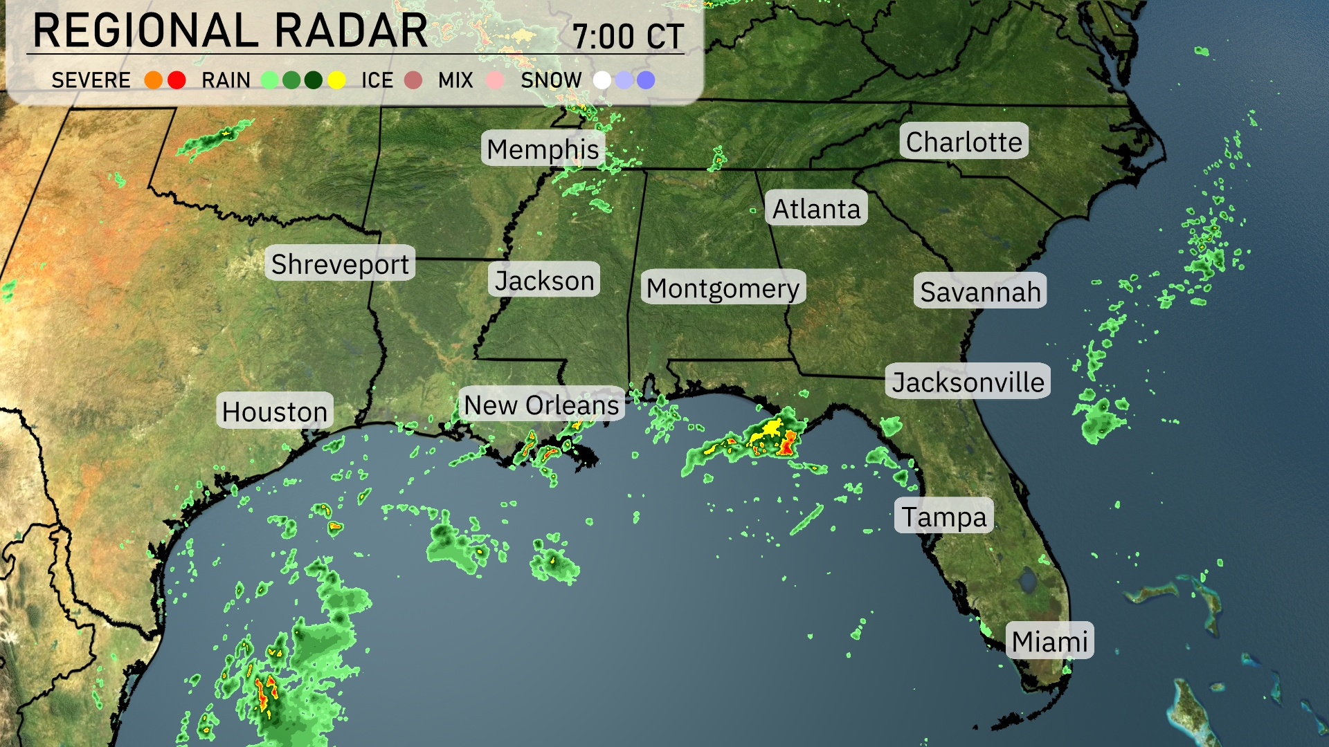
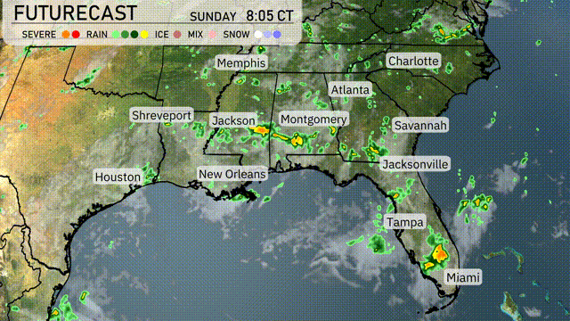
On the Regional Radar, showers are predominant over the Gulf Coast, particularly in Southern Louisiana near New Orleans, with storms moving towards the Florida Panhandle, impacting areas around Panama City. Rain is also visible extending from Jacksonville towards the Atlantic Ocean. The interior Southeast, including cities like Atlanta and Charlotte, remains mostly clear, providing a quiet weather day. Scattered clouds can be seen drifting through the lower Mississippi Valley, possibly bringing light rain to parts of Mississippi and Alabama later on.
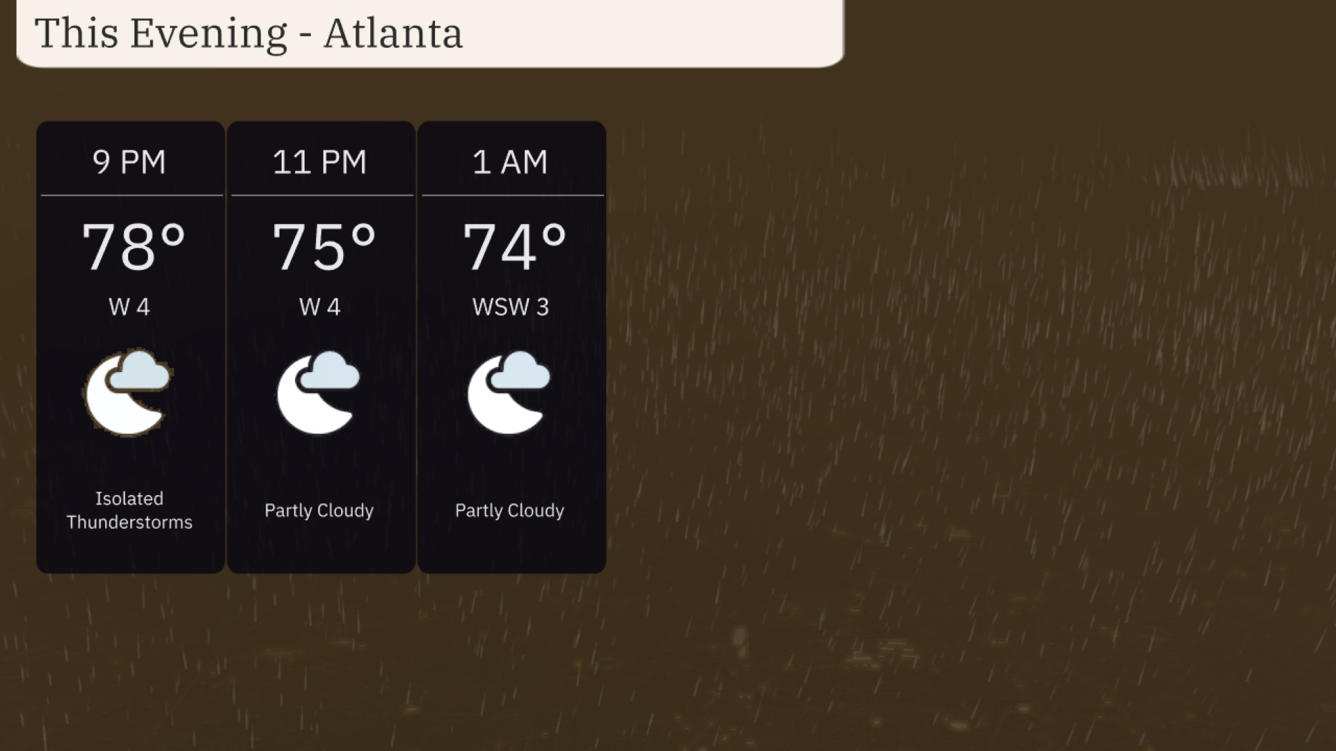
For this evening in Atlanta, the weather includes varying conditions. The temperature will start at 78 degrees with isolated thunderstorms at 9 PM, shifting to partly cloudy skies by 11 PM as temperatures drop to 75 degrees. By 1 AM, it will remain partly cloudy with a temperature of 74 degrees, and winds from the west-southwest at around 3 mph. Be prepared for a possible thunderstorm early in the evening, calming to more settled weather as the night progresses.
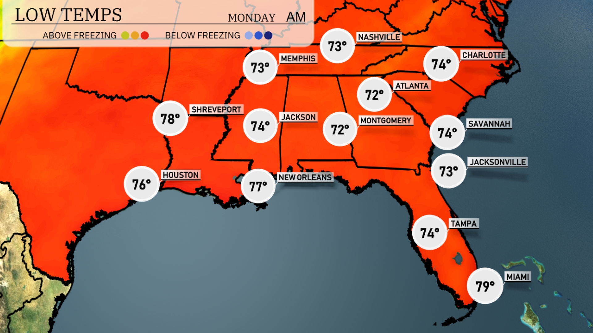
Tonight, temperatures in the Southeast will remain mild, with Memphis and Nashville both dropping to around 73 degrees. Jackson will see a low of 74, while Montgomery dips to 72. In Atlanta and Savannah, lows will also hold steady at 72 and 74 degrees, respectively. Expect it to be a warm night in the coastal cities, with Jacksonville at 73 and Tampa at 74.
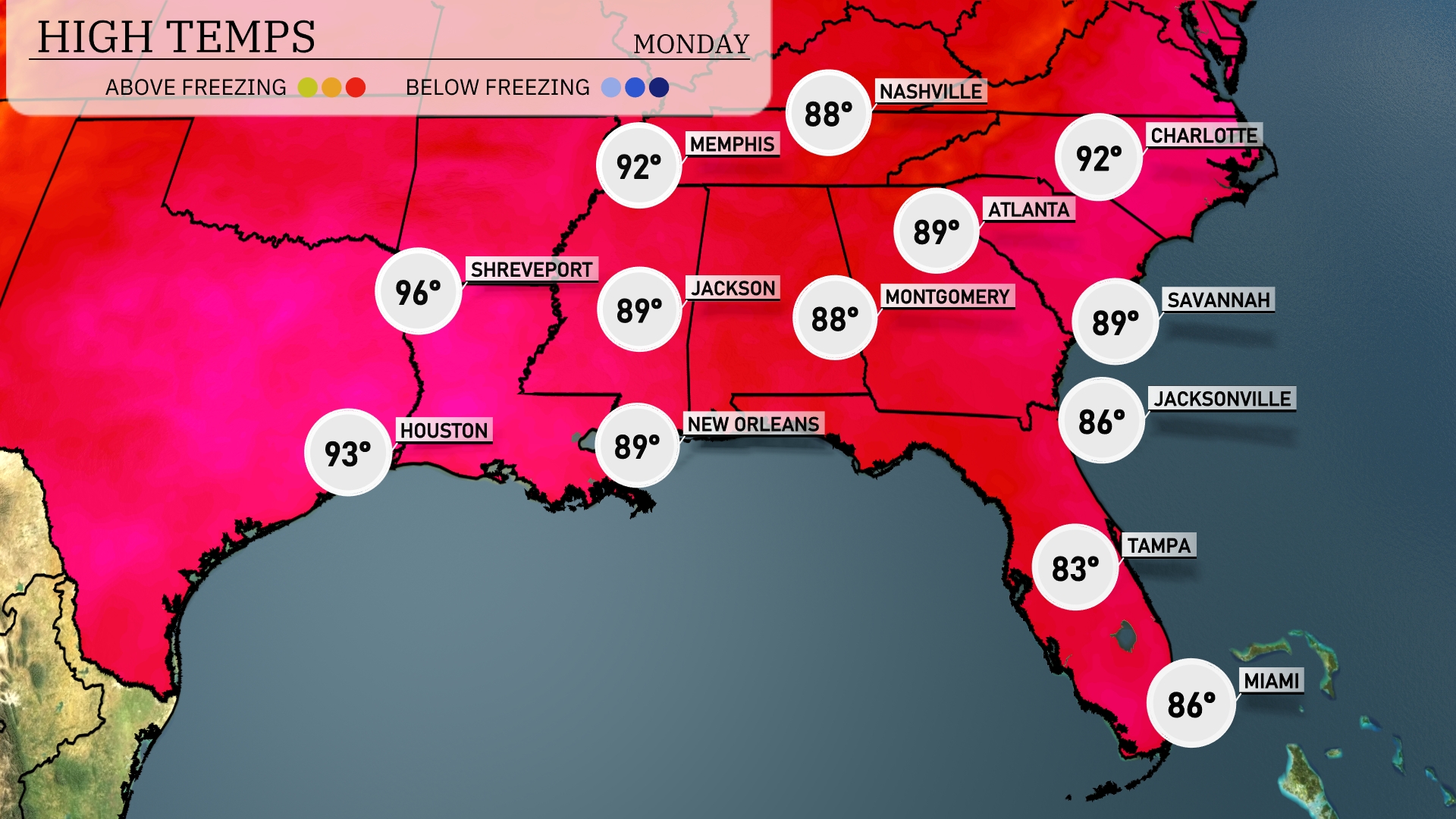
Tomorrow in Memphis, expect a high of 92 degrees, while Nashville will reach 88. Jackson and New Orleans are both forecasted to hit 89 degrees. Atlanta will see temperatures climbing to 89 as well, with Charlotte also warming up to 92. The overall trend shows above-average temperatures across the Southeast, influenced by persistent high pressure bringing warm air into the region.
As a cold front approaches from the west, thunderstorms are set to develop across the Southeast, particularly impacting areas from Jackson to Atlanta by late Sunday evening. Expect pockets of heavy rain and possible strong winds, especially from Montgomery to Jacksonville overnight. Rain totals could exceed an inch, so watch for localized flooding in low-lying areas. Temperatures are expected to dip slightly behind the front, but mild conditions and clearing skies are anticipated as we head into Monday across the Southeast. Stay alert for any severe weather alerts and prepare for possible travel disruptions due to slick road conditions.
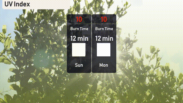
The UV index in Atlanta is very high at 10 for both Sunday and Monday, with a burn time of just 12 minutes in direct sunlight. Make sure to limit your sun exposure and seek shade when possible. Protective measures such as sunscreen and hats are highly advised.
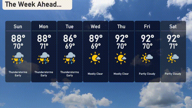
For the 7-day forecast in Atlanta:
Sunday: Thunderstorms are expected with a high of 88 degrees and a low of 70 degrees.
Monday: More thunderstorms early on, with a high of 88 degrees and a low of 71 degrees.
Tuesday: Thunderstorms early, cooling slightly with a high of 86 degrees and a low of 69 degrees.
Wednesday: Mostly clear skies, warming up to 89 degrees during the day and a low of 69 degrees at night.
Thursday: Expect mostly clear conditions with a high reaching 92 degrees and a low of 70 degrees.
Friday: Partly cloudy skies, staying warm with a high of 92 degrees and a low of 70 degrees.
Saturday: Partly cloudy again, with temperatures peaking at 92 degrees and a low of 71 degrees.
Stay safe and enjoy your week!