Atlanta Weather This Week: From Sunny Days to Thunderous Nights
By
Amy Freeze
Explore what the weather holds for Atlanta this week, with updates on daily temperatures and expected weather changes from sunny afternoons to stormy evenings.
This week in Atlanta, prepare for a mix of sun and storms. Check out our daily breakdown, from today’s gentle breezes to upcoming thunderous forecasts!
Discover what Atlanta’s weather looks like this week with our day-by-day forecast. From partly cloudy skies today to the good chances of thunderstorms by next Tuesday. We also delve into practical tips on how to stay safe and enjoy each day despite the fluctuating weather patterns. Remember, whether it’s grabbing your sunglasses or your umbrella, preparation is key! Visit our detailed post at https://amyfreeze.ai/ for more.
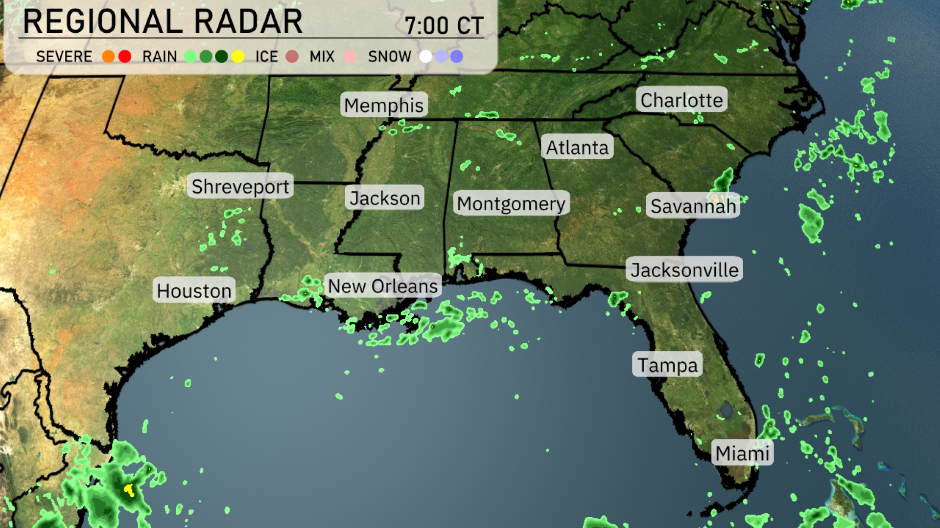
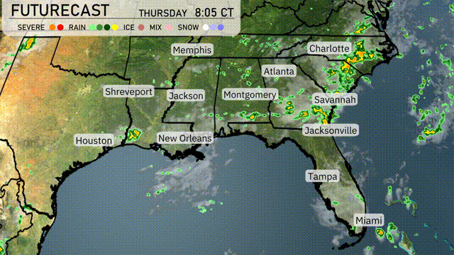
The regional radar shows isolated rain showers across the Gulf Coast from New Orleans to Houston, with light precipitation pushing toward the Florida panhandle and Jacksonville area. Today, the southeast enjoys mostly clear skies with only some scattered showers noted around Savannah and the coastal regions of South Carolina. Cloud cover is observed increasing as you move towards Atlanta, suggesting the potential for more rain. Meanwhile, cities like Charlotte and Memphis are currently experiencing calm conditions without rain.
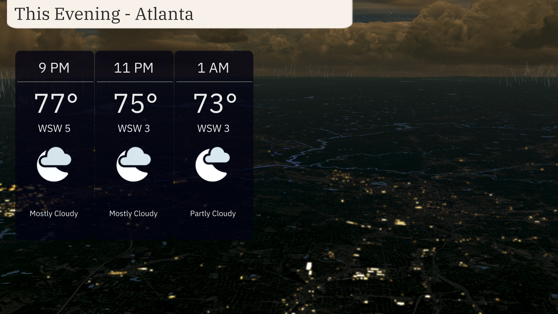
Evening in Atlanta brings mostly cloudy skies, with temperatures gently falling from 77 degrees at 9 PM to 73 degrees by 1 AM. Expect light winds from the west-southwest around 5 to 3 miles per hour through the night. A calm atmosphere prevails as clouds begin to thin out slightly towards early morning.
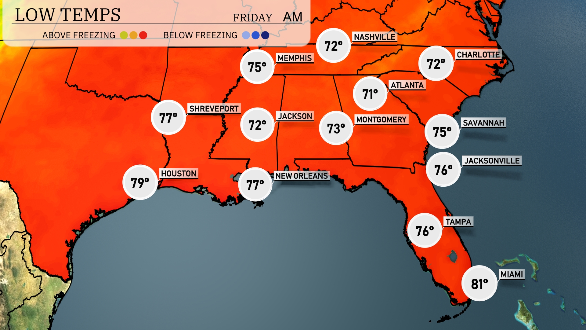
Tonight, Nashville will see a low of 72 degrees, while Memphis drops to 75. Shreveport is expecting a low of 77, and Jackson will cool to 72. Atlanta will experience a mild night with temperatures around 71, while Montgomery hits 73.
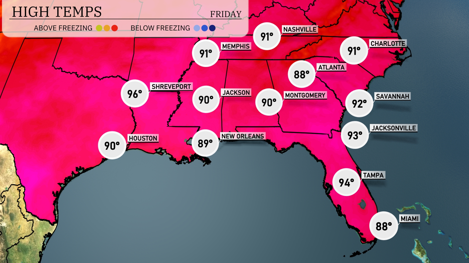
Tomorrow in the Southeast, expect a hot day ahead with temperatures soaring. Shreveport hits a high of 96 degrees, while Houston reaches a warm 90. Nashville sees a high of 91, with Atlanta close behind at 88 degrees. Jacksonville will be quite warm at 93, and Tampa will peak at 94 degrees. Overall, much of the region is experiencing above-average temperatures, consistent with the persistent warm air mass in place.
A cold front pushes eastward across the Southeast, bringing scattered thunderstorms from Houston to Atlanta by Thursday afternoon. Expect heavy rain and strong wind gusts, particularly in areas like Shreveport and New Orleans. Severe weather risks include localized flooding and potential isolated tornadoes. Temperatures will dip slightly behind the front, offering a cool down from Jackson to Charlotte. As the front progresses, plan for wet conditions extending into Jacksonville and Savannah by Thursday evening.
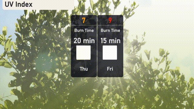
The UV index in Atlanta will reach a high of 7 on Thursday, indicating a burn time of about 20 minutes in direct sunlight. On Friday, the UV index climbs to a very high 9, with a quicker burn time of just 15 minutes. Protect your skin with sunscreen, hats, and sunglasses if you’re out and about!
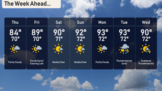
For the 7-day forecast in Atlanta:
Thursday: Partly cloudy with a high of 84 degrees and a low of 70 degrees.
Friday: Clouds early, clearing late with a high of 89 degrees and a low of 70 degrees.
Saturday: Mostly clear skies with a high of 90 degrees and a low of 71 degrees.
Sunday: Another mostly clear day with temperatures hitting a high of 92 degrees and dropping to 72 degrees at night.
Monday: Partly cloudy conditions will persist, with a daytime high reaching 93 degrees and a nighttime low of 72 degrees.
Tuesday: Thunderstorms are expected, keep an eye out for strong weather, with a high of 93 degrees and a low of 72 degrees.
Wednesday: Scattered thunderstorms with a high temperature of 90 degrees and a low of 72 degrees.
Hope this helps with your plans for the week! Stay safe!