Atlanta’s Weather This Week: From Sunshine to Thunderstorms
By
Amy Freeze
Explore a week of fluctuating Atlanta weather, from sunny afternoons and stormy nights to unexpected cool fronts. Perfect for those planning their week or tracking local weather trends.
This week in Atlanta, anticipate a mix of partly sunny days and potential stormy evenings with a slight cooldown. Gear up to tackle a variety of weather conditions from heatwaves to thunderstorms.
Atlanta’s weather takes us on a vibrant journey this week with temperatures soaring up to 96 degrees and dipping as low as 72 at night. Days are mostly clear but don’t let that deceive you, as stormy evenings with heavy rainfall are expected especially mid-week. From daily temperature swings to thunderstorms, stay updated with our comprehensive guide to navigating Atlanta’s eclectic weather.
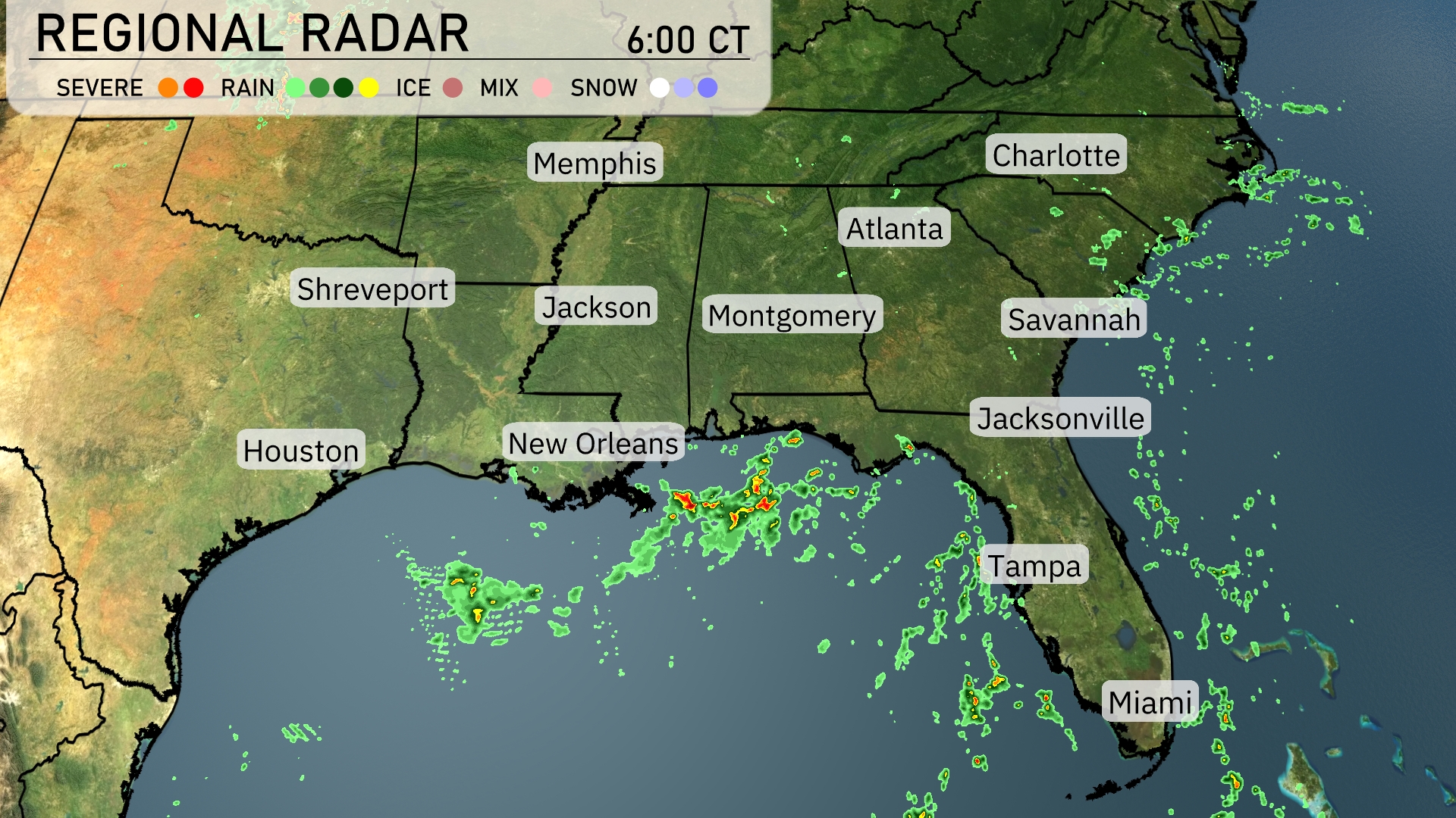
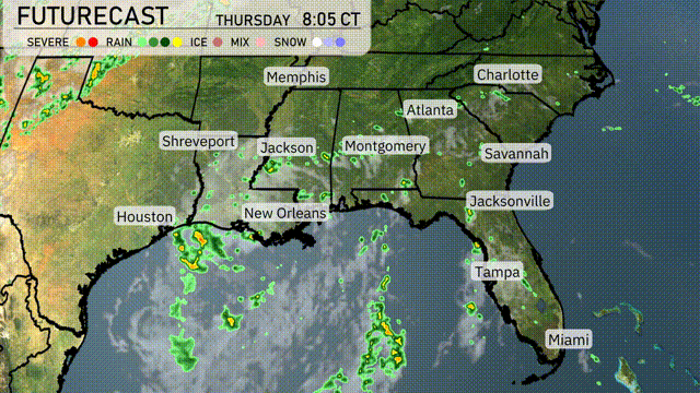
The Southeast region is seeing some stormy activity, especially along the Gulf Coast. Severe thunderstorms are forming offshore, near New Orleans and heading towards the coast bringing heavy rain and potential severe weather conditions. Meanwhile, light scattered showers are present across parts of southern Mississippi and Alabama, with clouds beginning to gather as they move into Georgia. The rest of the region, including major cities like Atlanta and Charlotte, is currently clear but keep an eye on the approaching rain.
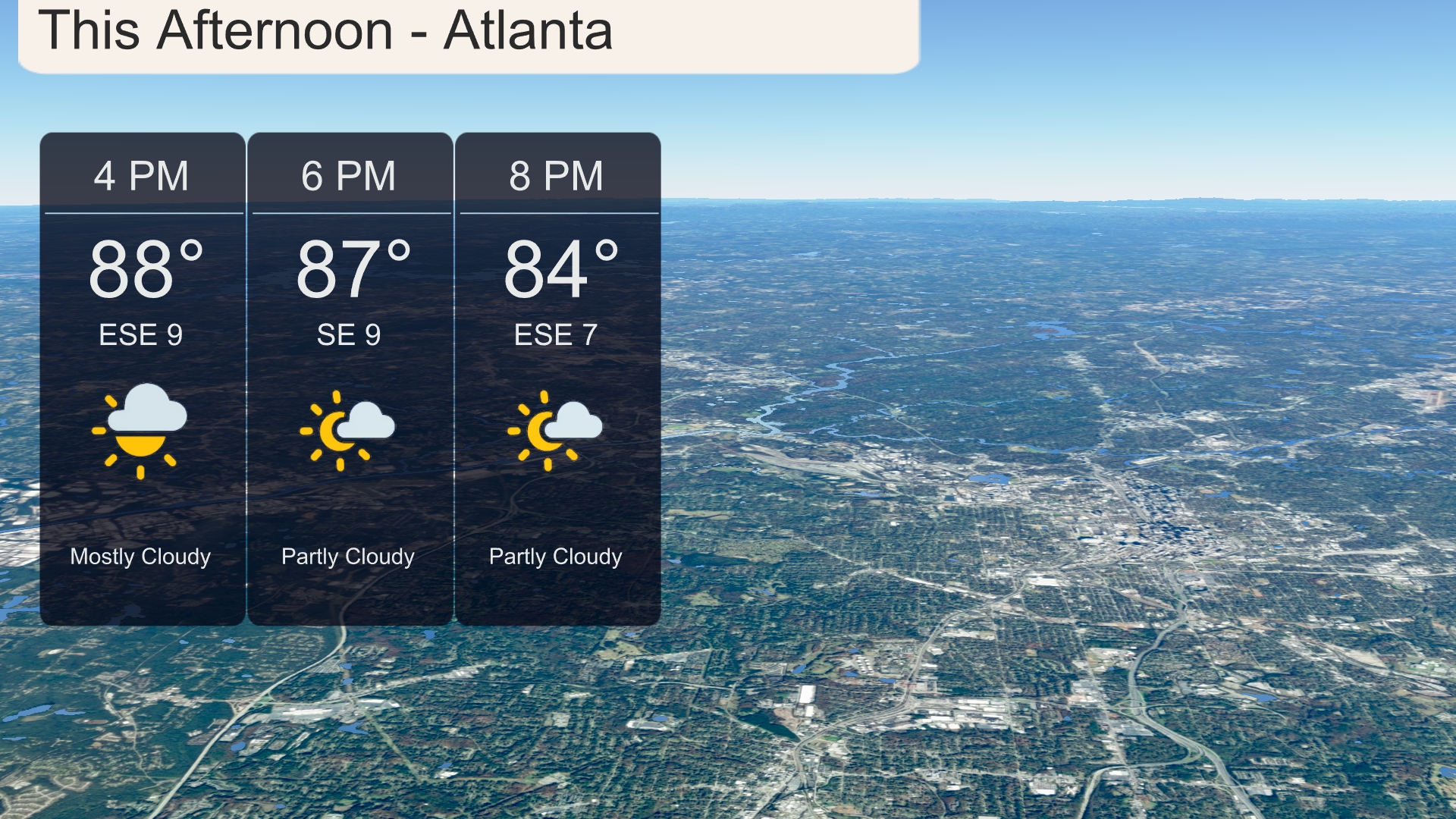
This afternoon in Atlanta, temperatures will reach up to 88 degrees around 4 PM, gradually decreasing to 84 degrees by 8 PM. Expect mostly cloudy skies initially, becoming partly cloudy later in the afternoon. Winds will shift from east-southeast at 9 miles per hour to southeast at the same speed. Overall, a warm and breezy afternoon with some sun peeking through the clouds.
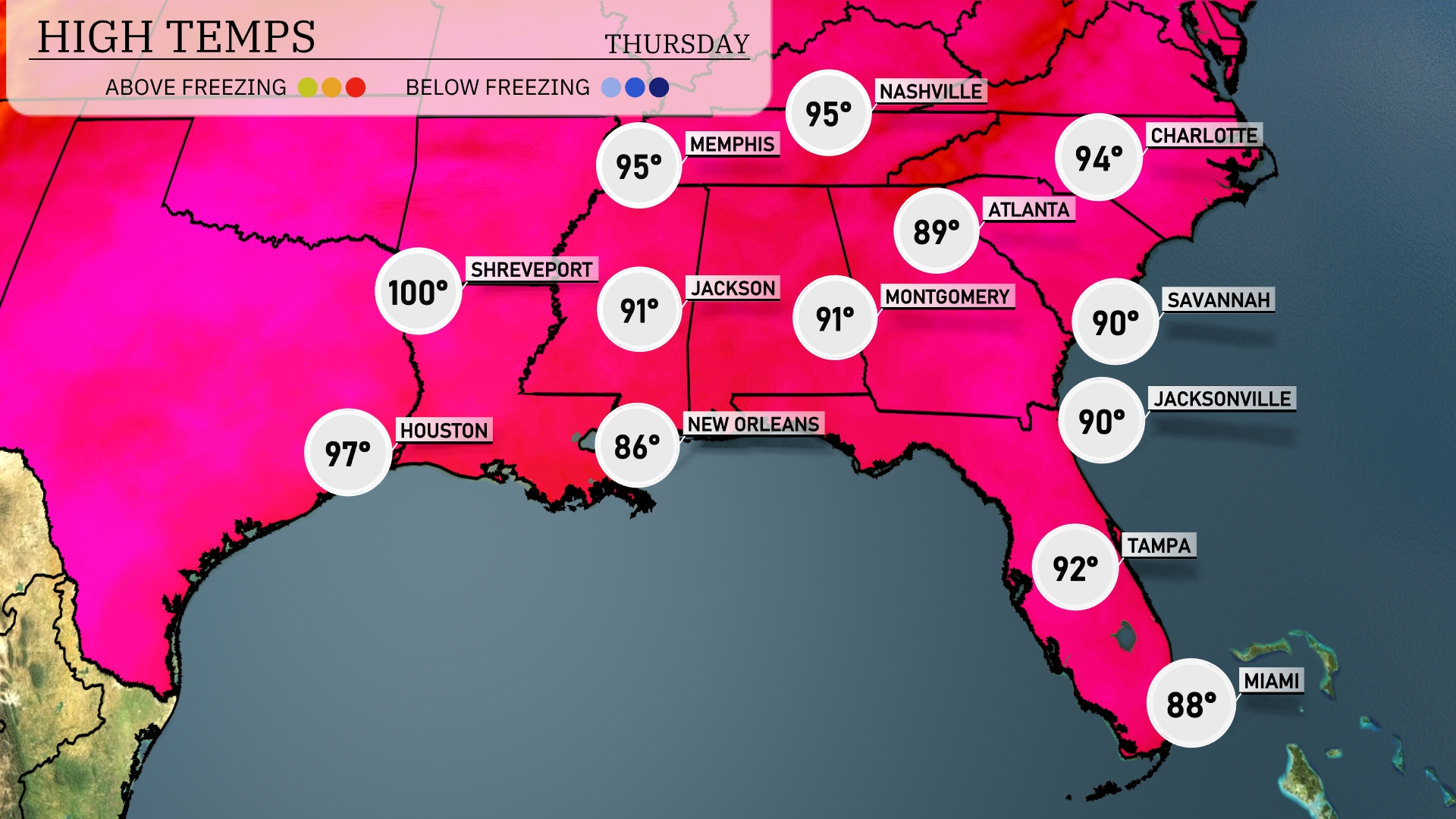
Today’s high temperatures are quite variable across the Southeast. In Shreveport, we’re expecting a scorching high of 100 degrees, while Houston will be slightly cooler at 97. Over in Jackson, temperatures will reach 91 degrees, consistent with Montgomery’s high of 91 as well. Atlanta will see a warm 94 degrees, while nearby Savannah and Jacksonville will both come in at 90. Expect a more comfortable day in New Orleans with a high of 86.
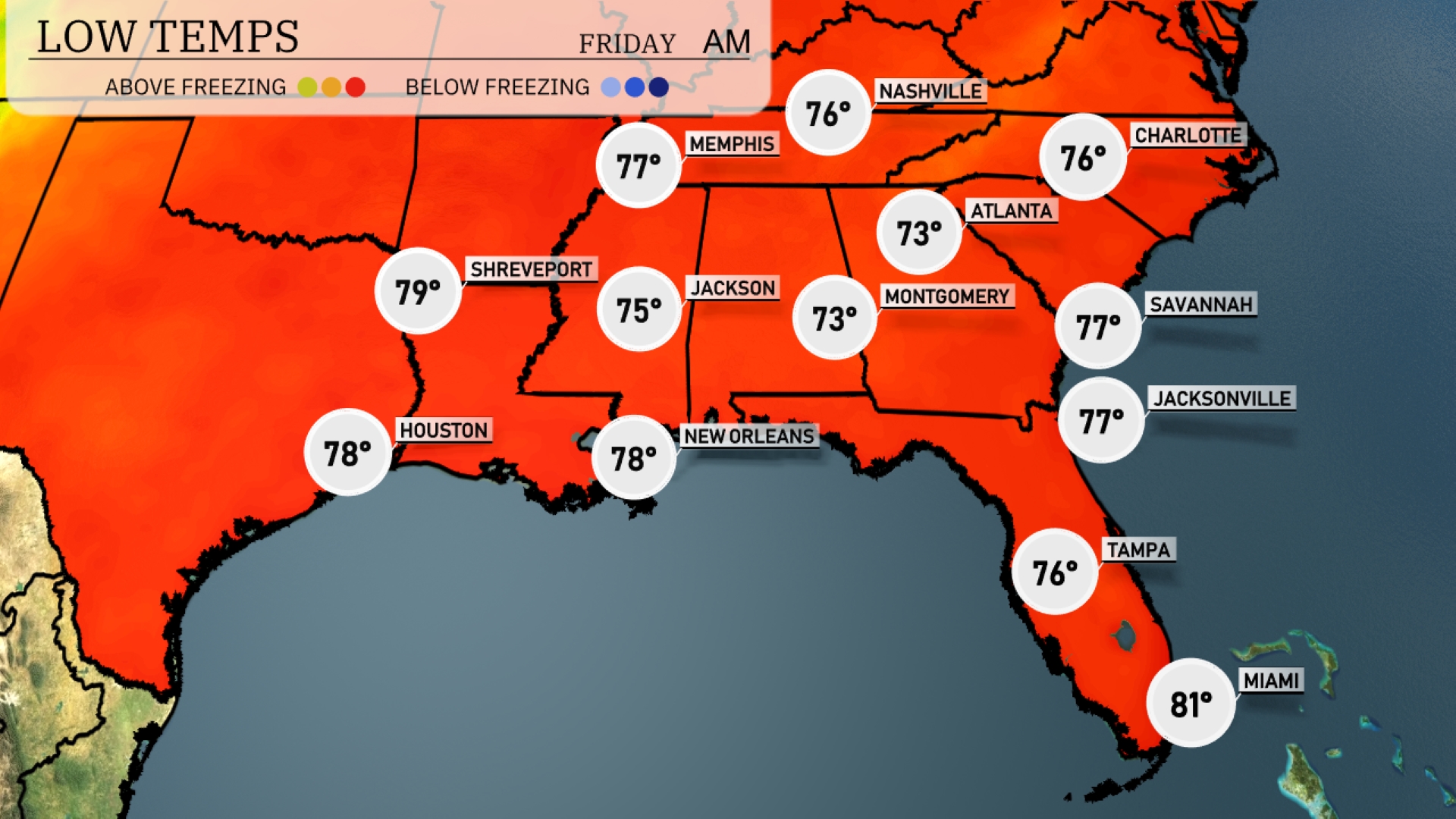
Tonight, expect lows of 76 degrees in Nashville and 75 degrees in Jackson. Atlanta will see a cooler night with temperatures dropping to 73 degrees. Over in Montgomery, expect a low of 73, while Charlotte will dip to 76. The warmest area will be Miami, resting at 81 degrees.
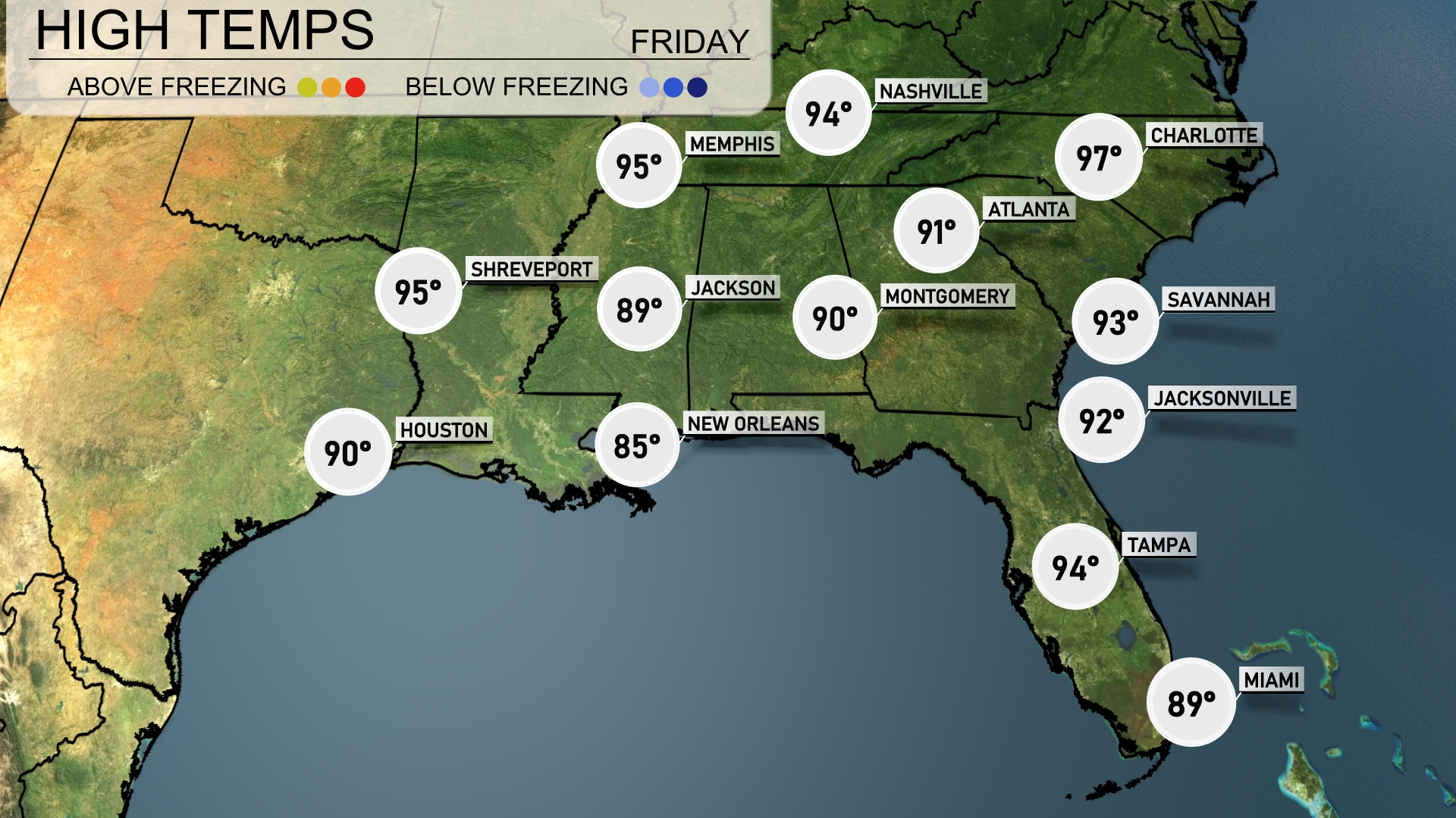
Tomorrow, Atlanta will see a high of 91 degrees, while Charlotte is expected to heat up to a sizzling 97 degrees, marking above-average temperatures for the area. Jacksonville is warming to 92 degrees and Savannah is close behind at 93. Further west, temperatures in New Orleans will reach 85 degrees, and Jackson will see a high of 89. Houston rounds things out with a temperature hitting 90 degrees, influenced by a warm air mass sweeping across the region.
A cold front from Texas and Louisiana will advance eastward tonight, bringing thunderstorms and heavy rainfall to parts of Mississippi, Alabama, and the Florida Panhandle. Expect the most active weather to hit overnight into tomorrow morning, with potential for heavy rain and gusty winds, particularly near Montgomery and Atlanta during the commute hours. Rainfall amounts could exceed an inch in these areas. The system will push into Southern Georgia, affecting Savannah and Jacksonville by afternoon. Behind the front, cooler and drier conditions will settle in, providing a brief respite from the heat and humidity across the region.
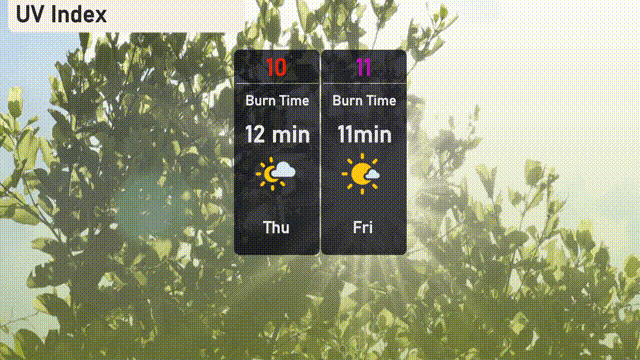
For Thursday in Atlanta, the UV index climbs to 10, with potential sun risks reaching 12-minute burn times. Stay protected with sunscreen and hats! By Friday, the UV index intensifies to 11, where unprotected skin could burn in just 11 minutes.