Steam and Storms: A Week of Weather Wonders in Atlanta with Amy Freeze
By
Amy Freeze
Discover Atlanta's fluctuating weather patterns through Amy Freeze's detailed forecast, informing you from sunny highs to stormy evenings.
Join Amy Freeze for a snapshot of Atlanta’s weather landscape: from warm sunny afternoons to challenging stormy nights. Plan your week with accurate and dynamic weather insights.
Amy Freeze provides an in-depth analysis of Atlanta’s weather, detailing daily conditions ranging from markedly high temperatures to potential severe weather events. This comprehensive guide discusses the broader regional impacts, daily temperature fluctuations, and practical tips for dealing with diverse weather phenomena. Each day’s forecast includes specific metrics such as UV indexes and suggested precautions, ensuring you stay safe and well-prepared.
On the Regional Radar, thunderstorms are sweeping across the northwestern edge of the Southeast region, moving through Arkansas and into Memphis. Expect heavy rain and occasional lightning as this storm system progresses. Meanwhile, Jackson is seeing some moderate rain extending towards Montgomery. The wet weather is also making its way northeast towards Atlanta. In contrast, areas farther east, including Charlotte and Savannah, are currently experiencing clearer conditions with minimal cloud cover. The coastline of Jacksonville is free of precipitation for the moment, providing a brief respite in Northern Florida. As we move down to Miami and Tampa, clear skies dominate, offering pleasant weather for these coastal cities.
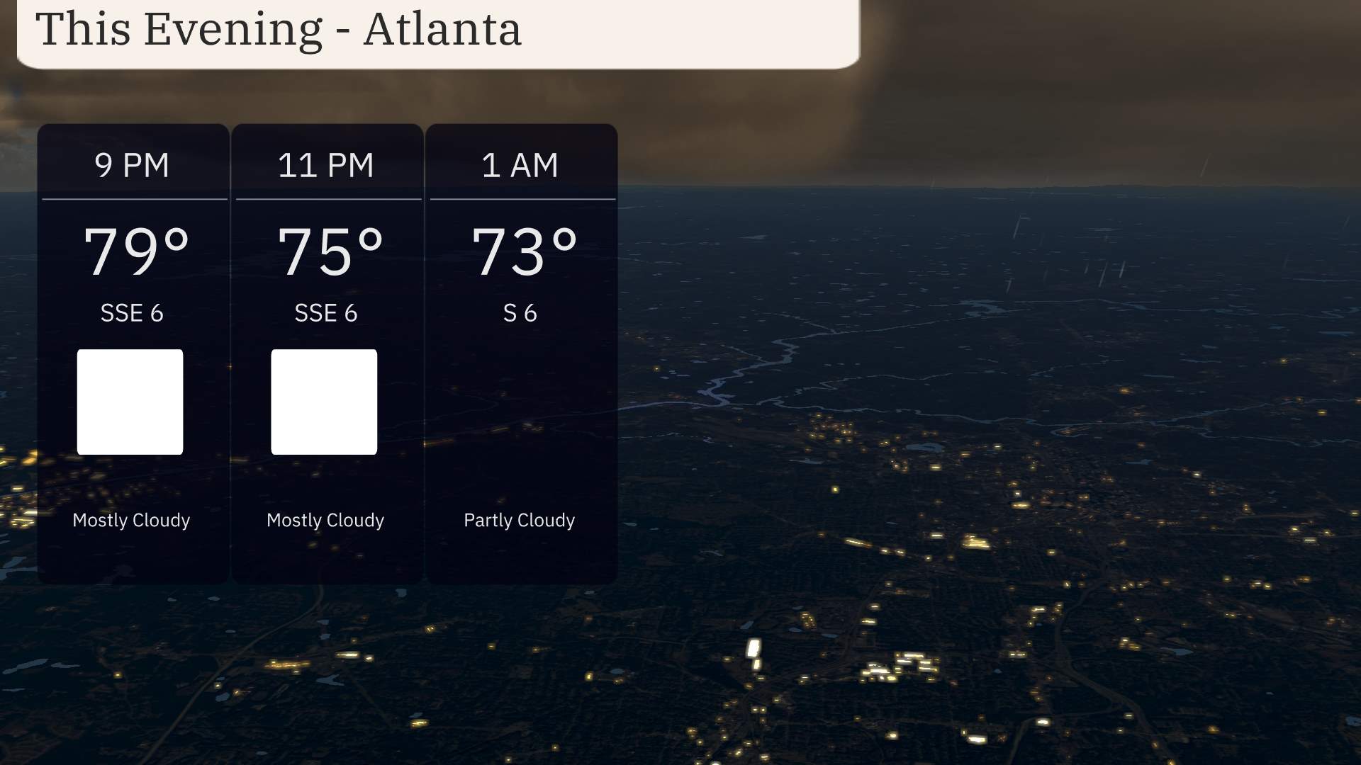
For this evening in Atlanta, anticipate a mostly cloudy start, with temperatures at 79 degrees around 9 PM. Winds are coming from the south-southeast at 6 miles per hour. By 11 PM, temperatures ease down to 75 degrees, with continued mostly cloudy skies. By 1 AM, expect partly cloudy conditions as temperatures settle at 73 degrees with south winds at 6 miles per hour.
Memphis will see a low of 48 degrees, while Nashville isn’t far behind at 52. Jackson will experience a cooler 59 degrees. Shreveport will register 50 degrees, a significant drop for the area. Atlanta will hold steady at 66. In the coastal cities, Savannah and Jacksonville will be around 68 and 70, respectively, while Tampa feels mild at 70. Down in Miami, expect a comfy 75 degrees.
Tomorrow in the Southeast, we can expect some significantly warm temperatures across the region, well above the seasonal averages for this time of year.
Atlanta is projected to reach a high of 86 degrees, while Montgomery will come in at a steamy 88 degrees. Jackson is not far behind, with a high of 84 degrees expected. In contrast, Nashville will also see warm readings, hitting around 75 degrees.
The Florida cities are really feeling the heat, with Tampa forecasted to sizzle at 91 degrees and Jacksonville hitting a steamy 90 degrees. Over at the Atlantic coast, Savannah will reflect a pleasant high of 82 degrees, while Miami is set to reach 82 degrees as well.
These temperatures are indicative of a warm front that’s been settling over the Southeast, bringing with it humid conditions and stable high-pressure systems that are pushing temperatures upward across the board.
In the Southeast tomorrow, a robust weather system is set to impact the region, bringing diverse conditions over the next 24 to 48 hours. A significant cold front is moving across the area, starting in Texas and pushing eastward into Louisiana, Mississippi, and Alabama. This will elevate the risk for strong thunderstorms, particularly during the afternoon and evening, stretching from Houston to Jackson. As this front approaches, expect widespread rain and the possibility of isolated severe storms. Look out for potential flooding, particularly in areas already saturated with water. Thunderstorms will transition into Georgia by early morning Thursday, affecting the Atlanta commute. With the frontal passage, temperatures will drop slightly, bringing cooler and drier air behind the system. Be prepared for severe weather advisories, especially near New Orleans and Memphis.
For Atlanta, Friday brings a moderate UV index of 4, with a burn time of about 35 minutes under direct sunlight. On Saturday, expect the UV index to reach a high of 8, making sun exposure more intense with a faster burn time of just 17 minutes.
For the 7 Day Outlook in Atlanta:
Friday: Clouds early but clearing later, with a high of 88 degrees and a comfortable low of 66.
Saturday: Mostly cloudy conditions, with temperatures cooling to 68 degrees and a low of 68.
Sunday: Thunderstorms likely; temperatures reach 73 degrees and a low of 58.
Monday: Expect partly cloudy skies, cooling down to a high of 61 degrees and a low of 42.
Tuesday: Clear skies dominate, with a pleasant high of 64 degrees and a low of 38.
Wednesday: Mostly clear conditions, as temperatures rise to a high of 68 degrees and a low of 44.
Thursday: Partly cloudy skies return, with a mild high of 75 degrees and a low of 51.
Hope that helps, and enjoy the week ahead in Atlanta!