Atlanta’s Hour by Hour: A Meteorological Journey with Amy Freeze
By
Amy Freeze
Join Amy Freeze as she breaks down Atlanta's weather forecast, from bright sunny mornings to looming thunderstorms. Discover how to prepare for the Southeast’s dynamic weather conditions.
Meteorologist Amy Freeze covers this week’s weather in Atlanta, from clear skies to storm warnings. Get the full picture and tips on how to prepare!
Get ready to navigate the week’s weather in Atlanta with your favorite meteorologist, Amy Freeze. Expect everything from sunny mornings with clear skies to potential severe thunderstorms by evening. We’ll have updates on temperature changes, UV index alerts, and safety tips. For hour by hour updates, visit our blog!
Storms are currently moving through the northern part of the Southeast region, particularly impacting areas from Jackson, Mississippi, up towards Charlotte, North Carolina, with scattered showers. As rain envelops parts of Alabama, Montgomery is likely to experience brief periods of precipitation, while nearby regions brace for more cloud cover. The coastal stretch from Savannah to Charleston enjoys a period of dry and partly cloudy skies, offering a temporary relief from the wet weather. Meanwhile, New Orleans and Houston maintain stable conditions with no notable precipitation expected in the coming hours.
In Atlanta tomorrow morning, expect sunny skies beginning at 7 AM with a temperature of 46 degrees. By 9 AM, temperatures will rise to 55 degrees, accompanied by a northwest wind at 10 miles per hour. By 11 AM, look for a temperature of 63 degrees with a continued northwest breeze at 11 miles per hour.
Tomorrow, the Southeast will see warm temperatures significantly above average for this time of year. Atlanta is expected to reach a high of 75 degrees, while Jacksonville will climb to 79. In New Orleans, temperatures will hit 77 degrees, and Tampa is on track for a warm 82 degrees. Houston and Shreveport will both see highs around 82 degrees as well. This warm spell is influenced by a high-pressure system settling over the region, bringing clear skies and plenty of sunshine.
A cold front is advancing into the Southeast, with thunderstorms expected to develop from Houston to Shreveport. Heavy rain and potential severe storms, including damaging winds, will impact areas from Jackson to Montgomery by tomorrow evening. Coastal regions, like Mobile and New Orleans, should brace for downpours with localized flooding risks. As the front progresses, expect cooler temperatures to follow, particularly across northern Mississippi and Alabama. Storm activity is set to ease by late Wednesday, giving way to drier conditions.
The UV index in Atlanta reaches a high of 8 on Tuesday, with a burn time of about 17 minutes, so be sure to apply sunscreen and wear hats when heading outdoors. As we move to Wednesday, the index rises to an even higher 9, reducing the burn time to just 15 minutes!
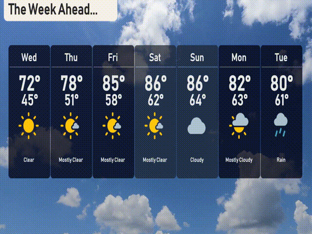
For the 7-day forecast in Atlanta:
Wednesday: Clear skies with a high of 72 degrees and a low of 45.
Thursday: Mostly clear and warming up with a high of 78 degrees and a low of 51.
Friday: Mostly clear skies and even warmer, reaching up to 85 degrees, cooling to 58 at night.
Saturday: Expect partly sunny conditions with a high of 86 degrees and a low of 62.
Sunday: Cloudy skies, maintaining warmth with a high of 86 degrees and a low of 64.
Monday: Mostly cloudy with temperatures peaking at 82 degrees during the day and dipping to 63 at night.
Tuesday: Rain is expected with the temperature reaching a high of 80 degrees and a low of 61.
Hope that helps in planning your week! Stay safe!