Cloudy with a Chance of Thunder: Atlanta’s Dynamic Weather Week Ahead
By
Amy Freeze
Explore the fascinating shifts in Atlanta's weather, from cloudy evenings to thunderous nights and serene mornings, in our detailed seven-day outlook.
This week in Atlanta, weather patterns offer a mix of thunderstorms and clear skies. Catch all details of what to expect each day!
Welcome to your detailed guide on Atlanta’s weather for the upcoming week. Experience everything from scattered thunderstorms to pleasant sunny days. We dissect the active patterns over the Southeast, highlight temperature contrasts, and provide safety tips for adverse weather conditions. Don’t miss our day-by-day breakdown to stay weather-aware.
The Southeast region is witnessing some active weather patterns today. A line of showers can be seen moving through the Gulf coast near New Orleans and stretching towards Houston. Meanwhile, storms are forming west of Memphis, and scattered rain is present along the coastline towards Miami. Atlanta and Charlotte seem to be under clear skies for now, but the cloud cover is expected to increase later as the rain moves northeast.
This evening in Atlanta, anticipate scattered thunderstorms starting around 9 PM with temperatures at 77 degrees and a southwest wind at 5 mph. By 11 PM, showers continue with temperatures dropping to 73 degrees and winds easing to 4 mph. Skies become cloudy by 1 AM, maintaining 73 degrees and a light southwest wind at 4 mph.
Tonight, Memphis will cool down to 73 degrees. Nashville is looking at a low of 71, while Jackson will see slightly cooler temperatures at 70. Montgomery will have a low of 72, and Atlanta will also settle at 71 degrees. Expect a mild night in Miami, with mild temperatures remaining at 81 degrees.
Tomorrow, Atlanta is expected to reach a high of 87 degrees, while Montgomery stays slightly warmer at 88 degrees. Both New Orleans and Jackson will see highs around 86 degrees. Jacksonville is set to be a bit toastier with a high of 89, and Tampa will be the warmest in the region at 91 degrees.
Saturday’s forecast for the Southeast shows a dynamic weather pattern developing. Scattered thunderstorms are expected across parts of Louisiana, Mississippi, and Alabama, with potential for heavy rainfall primarily from Jackson to Montgomery by afternoon. A cold front sweeps through by evening, enhancing the risk of strong storms, particularly around Atlanta and Charlotte, with winds and localized flooding possible. Temperatures will be cooler post-front but watch for more isolated storm development extending into Florida, from Jacksonville to Miami, throughout the day into Sunday.
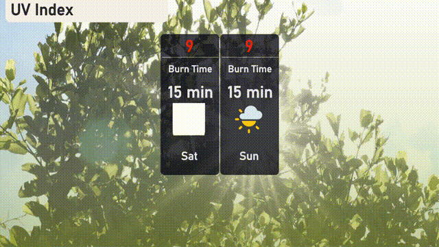
The UV index in Atlanta is a very high 9 on both Saturday and Sunday, with a rapid burn time of just 15 minutes in direct sunlight.
For the 7 Day Outlook in Atlanta:
Saturday: Thunderstorms early with a high of 86 degrees and a low of 69 degrees.
Sunday: Partly cloudy skies expected, peaking at 88 degrees with a low near 70 degrees.
Monday: Mostly cloudy conditions with highs around 88 degrees and lows at 70 degrees.
Tuesday: Partly cloudy weather continues, with the temperature reaching 87 degrees and an overnight low of 70 degrees.
Wednesday: A mostly cloudy day, temperatures will be around 87 degrees during the day and 72 degrees at night.
Thursday: Expect mostly cloudy skies with a high of 85 degrees and a low of 70 degrees.
Friday: The week wraps up with mostly clear conditions, hitting a high of 89 degrees and a low around 70 degrees.