From Calm to Storms: Navigating Atlanta’s Weather Patterns This Week
By
Amy Freeze
Explore the swings from clear skies to thunderstorms in Atlanta's forecast this week with insights from meteorologist Amy Freeze.
Meteorologist Amy Freeze covers this week’s fluctuating weather in Atlanta, from clear, sunny skies to expected thunderstorms. Keep updated with daily insights!
This week in Atlanta promises a range of weather conditions. Meteorologist Amy Freeze explains what to expect each day, from tranquil temperatures to storm alerts, and how to prepare for rapid changes. With an in-depth exploration of daily conditions and temperatures, this guide is your go-to for staying informed and ready, whatever the weather.
On the Regional Radar, a rain band is pushing through north central Georgia, bringing showers to Atlanta and moving towards Charlotte. Charlotte is seeing heavy rain, and Atlanta is not far behind, with echoes suggesting continuing rainfall. Scattered rain showers are also influencing the area south of Jacksonville. Meanwhile, Montgomery and Jackson are relatively quiet, but keep an eye on the approaching cloud cover that might spell rain later. Coastal areas like Miami and Tampa are currently experiencing clear conditions, but rain over the Gulf of Mexico could march eastwards, potentially affecting New Orleans soon.
For this evening in Atlanta, scattered thunderstorms are likely at 9 PM with temperatures at 74 degrees and a southwest wind at 3 miles per hour. By 11 PM, expect mostly cloudy skies with temperatures decreasing to 69 degrees and a north-northwest wind at 4 miles per hour. At 1 AM, showers are expected with temperatures around 66 degrees, continuing with a north-northwest wind at 4 miles per hour.
Tonight expect a low of 50 degrees in Memphis and just a touch cooler at 51 in Charlotte. Farther south, Atlanta will see a low of 60, while Montgomery drops to 63. New Orleans remains warmer at 66, but Jackson will feel the chill at 61. Overnight, Miami will stay very warm at 77 degrees.
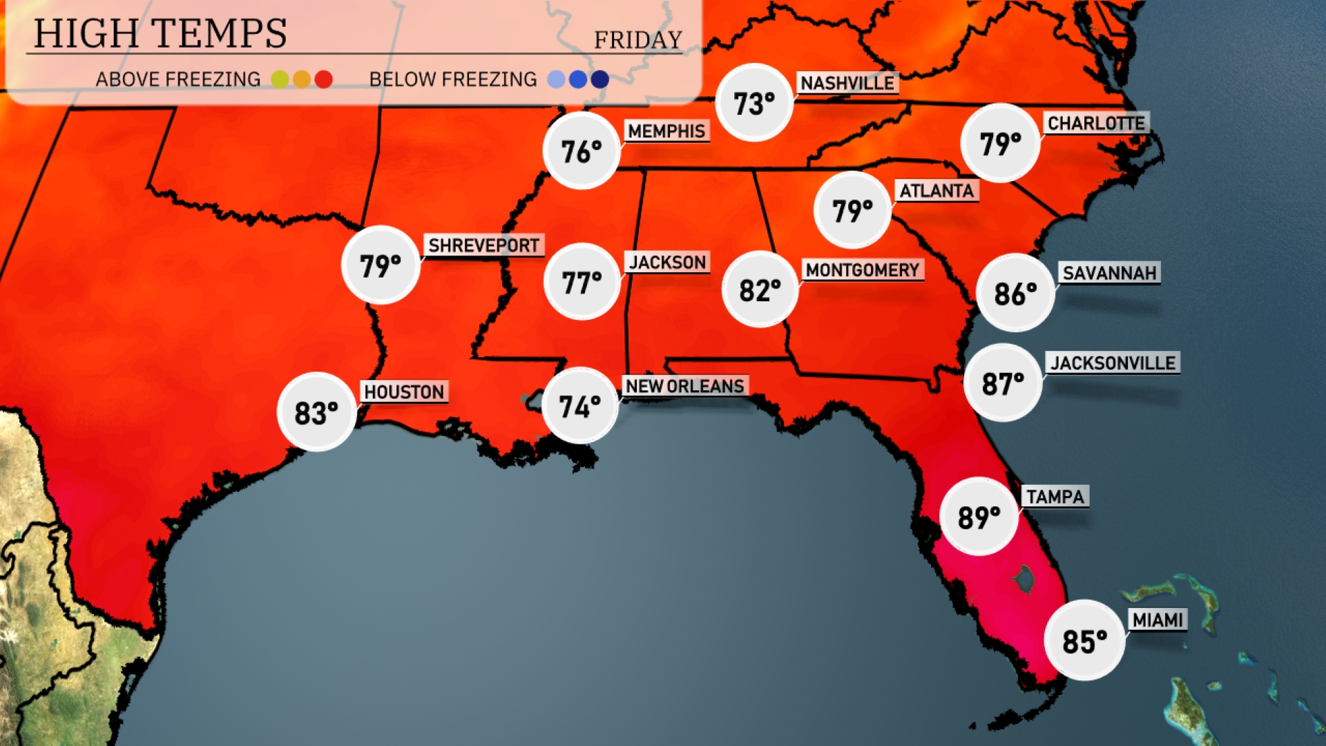
Tomorrow in the Southeast, high temperatures are expected to soar well above average, particularly in Florida. Tampa will lead the charge with a sizzling high of 89 degrees, while Jacksonville and Savannah will also see warm readings at 87 and 86 degrees, respectively. Inland, Montgomery, Alabama, is forecasted to reach 82 degrees, contributing to the overall warm trend. In contrast, areas like Memphis and New Orleans remain slightly cooler, with highs of 73 and 74 degrees.
A cold front moves across Southeast tomorrow, starting from areas in Texas transitioning toward Louisiana. Expect scattered thunderstorms with the potential for severe weather, including gusty winds and heavy rainfall, particularly impacting areas from New Orleans to Jackson by late afternoon. As it progresses, Montgomery, Birmingham, and Atlanta might experience early morning showers. Watch for localized flooding, especially in areas with poor drainage. As the system exits, drier and slightly cooler temperatures will settle in by weekend, providing relief from the recent humidity.
In Atlanta, brace for a high UV index of 9 on both Thursday and Friday, translating to a quick burn time of just 15 minutes in direct sunlight.
For the 7-day forecast in Atlanta:
Thursday: Scattered thunderstorms are expected with a high of 84 degrees and a low of 59.
Friday: Mostly cloudy conditions, with temperatures reaching up to 79 degrees and dipping to 59 at night.
Saturday: Showers are likely with a high of 69 degrees and a low of 56.
Sunday: Keep your umbrella handy as rain continues with a daytime high of 74 degrees and a low of 60.
Monday: Scattered thunderstorms return with highs around 68 degrees, cooling down to 61 degrees overnight.
Tuesday: Thunderstorms are possible, with temperatures peaking at 74 degrees and lows of 60.
Wednesday: The clouds clear up, leading to mostly clear skies and a warm high of 82 degrees, with a nighttime low of 63.