Atmospheric Adventures in Atlanta: A Detailed Week of Weather with Amy Freeze
By
Amy Freeze
Explore a week of weather in Atlanta through the expert insights of Meteorologist Amy Freeze, from sunny skies to imminent storms.
Meteorologist Amy Freeze breaks down the week’s weather in Atlanta—get ready for everything from warm, sunny days to potential thunderstorms and crucial weather alerts.
This week in Atlanta’s weather, we start with clear skies moving to a crescendo of potential thunderstorms stirred by a robust cold front. Meteorologist Amy Freeze details each day’s forecast, highlights temperature changes, and provides essential tips for dealing with severe weather conditions. From sunny afternoons to stormy evenings, this blog post covers all your weather needs with expert insights.
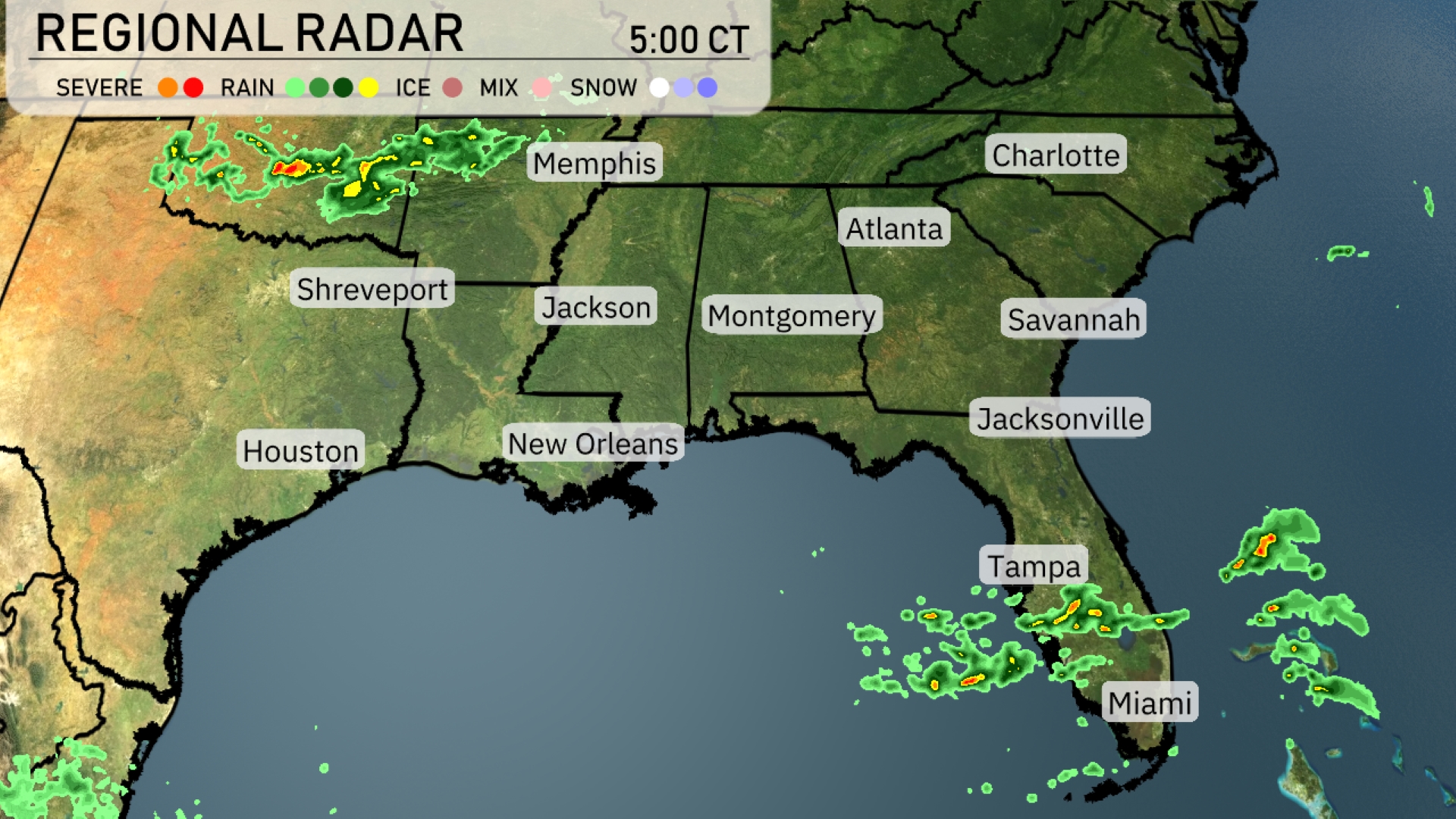
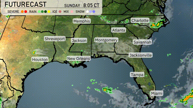
The Southeast radar shows active weather patterns with storms brewing along the Texas-Louisiana border. These severe storms are making their way toward Shreveport and Houston, bringing rain and potential thunderstorms. Rain showers are scattered across central Florida, with Miami and Tampa seeing some persistent activity. Meanwhile, the Gulf Coast from New Orleans to Jacksonville presents more isolated showers, but nothing too intense at the moment. Inland areas, including Montgomery and Atlanta, remain mostly clear with no significant cloud cover or precipitation.
Temperatures in Atlanta this afternoon will hover around 80 degrees with mostly cloudy skies. A west-northwest wind at 8 miles per hour will add a gentle breeze to the day. By 6 PM, expect it to be 79 degrees with a transition to partly cloudy skies and a slight shift to a west wind. As the evening progresses, temperatures will slightly drop to 77 degrees under mostly sunny skies with a calm wind from the west at 6 miles per hour.
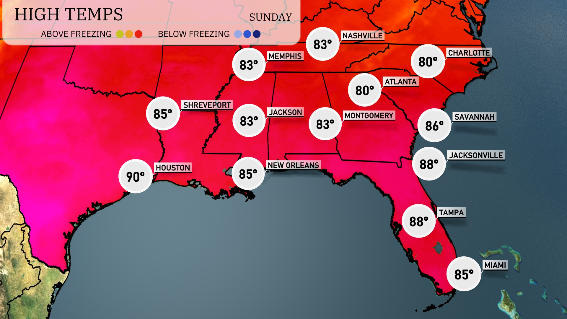
Today’s afternoon highs in the Southeast are heating up nicely. In New Orleans, expect a warm high of 85 degrees, while further east in Jacksonville, temperatures climb to 88 degrees. Savannah is not far behind, also reaching 86 degrees, showcasing the typical summer warmth of the region. Atlanta will see a high of 80 degrees, with occasional clouds moving through. In Houston, the temperature peaks at 90 degrees, making it the warmest city in the area today. Over in Memphis and Montgomery, highs are steady around 83 degrees, providing a comfortable day across the southern tier.
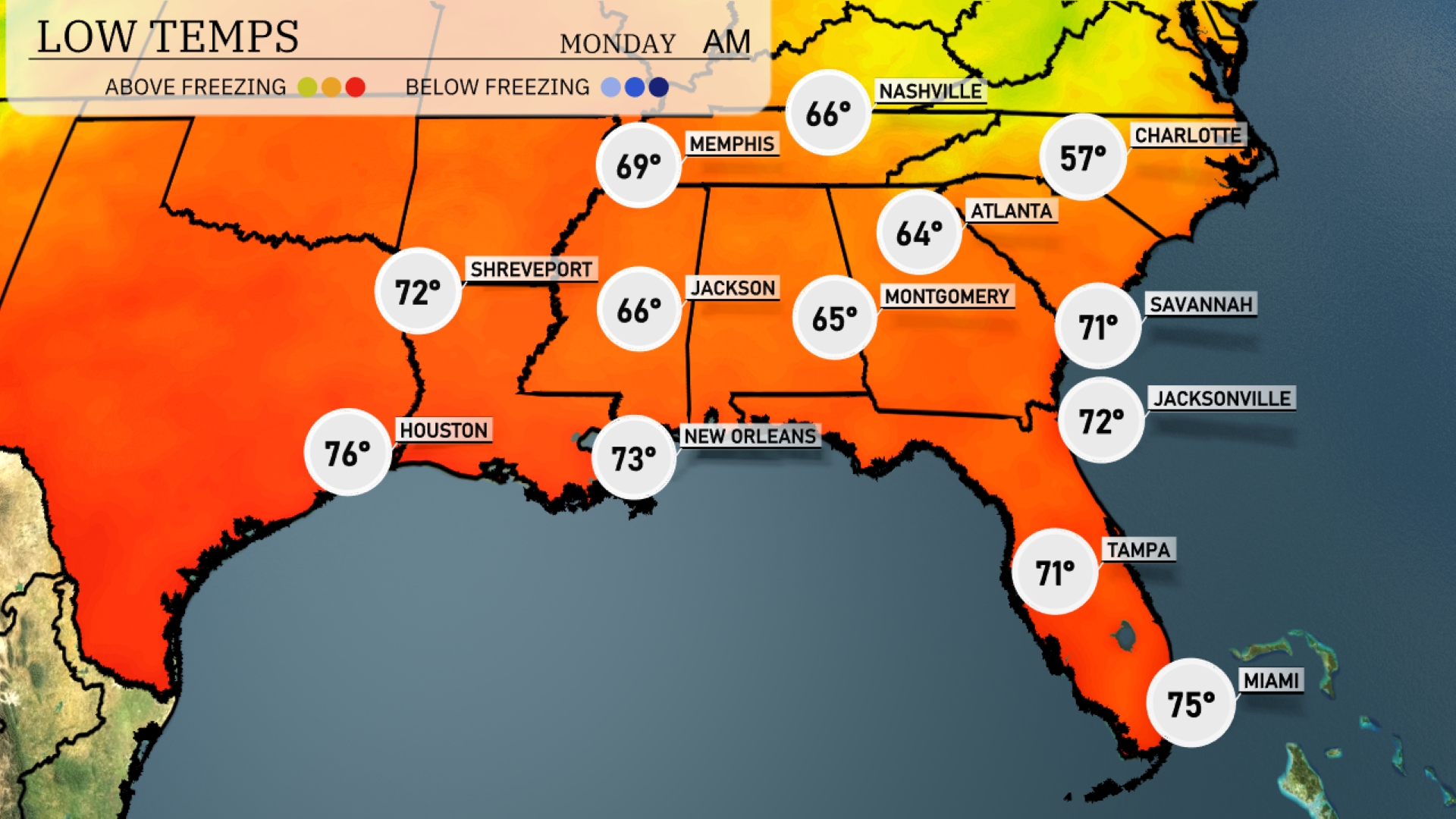
Tonight expect a low of 66 degrees in Memphis and 66 in Jackson. Nashville will see a drop to 64, while Atlanta cools down to 57. In contrast, the coast remains warmer, with lows of 71 in Savannah and 72 in Jacksonville. New Orleans will have a pleasant low of 73 degrees.
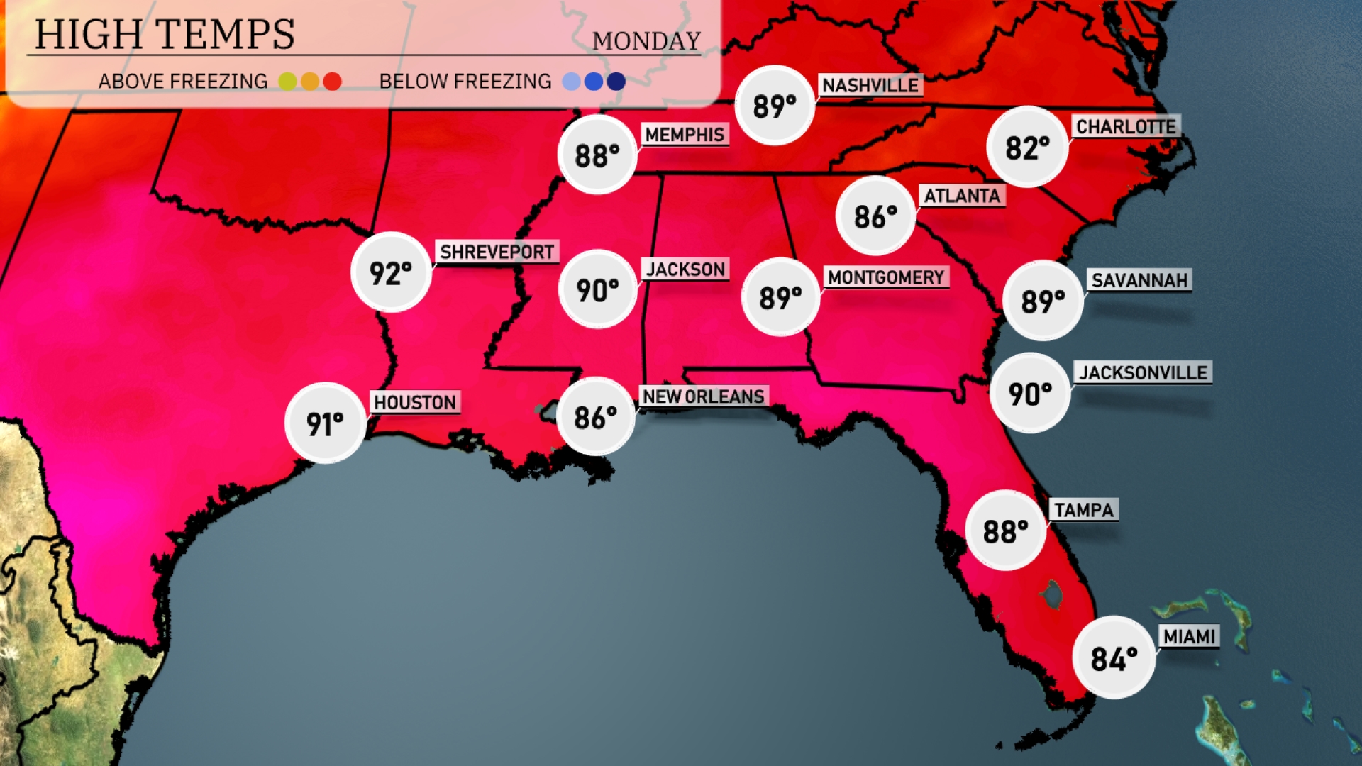
Tomorrow Atlanta will see a high of 86 degrees, while Jacksonville and Montgomery both expect highs of 90 degrees. Shreveport and Houston will be even warmer at 92 and 91 degrees, respectively. New Orleans will be slightly cooler at 86 degrees, but still well above normal for this time of year. Miami rounds out the region with a more temperate high of 84 degrees, keeping it mild compared to the rest of the Southeast.
A robust cold front will make its way through the Southeast, sparking thunderstorms from Houston to New Orleans and into Montgomery by late Monday evening. Expect heavy rainfall and strong winds, with potential flash flooding in low-lying areas, especially along the Gulf Coast. As the system advances, areas from Birmingham to Atlanta will encounter thunderstorms early Tuesday, affecting the morning commute. Temperatures behind the front will drop by several degrees, bringing a cooler and drier air mass midweek. Remain vigilant for severe weather alerts as these conditions unfold.
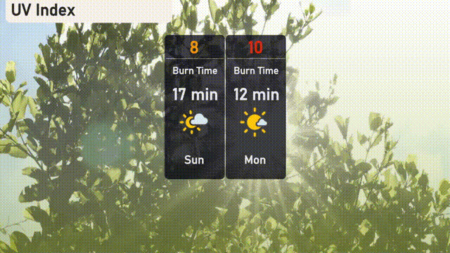
The UV index in Atlanta on Sunday is 8, presenting a high risk with a burn time of approximately 17 minutes for those spending time outdoors. Moving into Monday, the UV index rises to a very high level of 10, with the burn time reduced to just 12 minutes.