Weather Whirlwind in Atlanta: From Sunshine to Storms
By
Amy Freeze
Discover the dynamic weather pattern sweeping through Atlanta this week, from scorching heat to needed rain showers. Stay ahead with our daily forecast and essential weather safety tips.
This week in Atlanta, gear up for fluctuating weather conditions starting with showers, escalating to near-record temperatures, and closing out with intense thunderstorm possibilities.
Dive deep into Atlanta’s upcoming weather patterns. Beginning today with mild temperatures and scattered showers across the Southeast. As we progress, temperatures will climb, reaching their peak by midweek, with highs surging into the mid-90s. Extreme UV levels warn of severe sun exposure risks, making sun protection vitally important. The week concludes with potential thunderstorms, promising needed relief but also posing flooding risks. This dynamic week keeps all residents on their toes, underlining the importance of staying weather-aware.
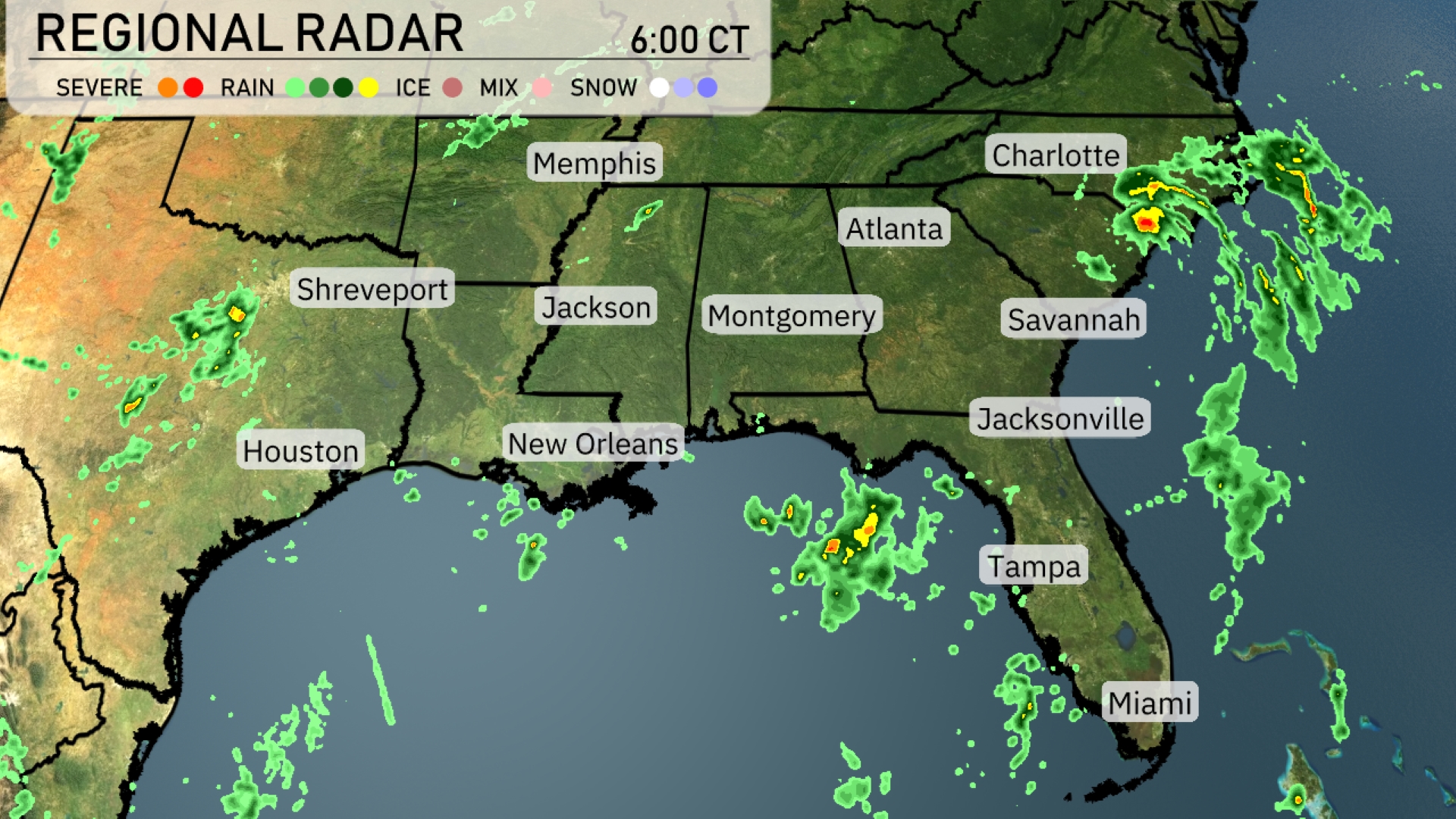
A band of showers is sweeping across northern Alabama into Georgia, with Atlanta experiencing consistent rain. In the coastal Carolinas, clouds dominate the sky as a storm system pushes in from the Atlantic. Scattered showers are popping up in central and southern Florida, with Jacksonville seeing intermittent rain. Meanwhile, clear conditions prevail over much of the Gulf Coast, including New Orleans and Houston, allowing for a relatively mild start to the day.
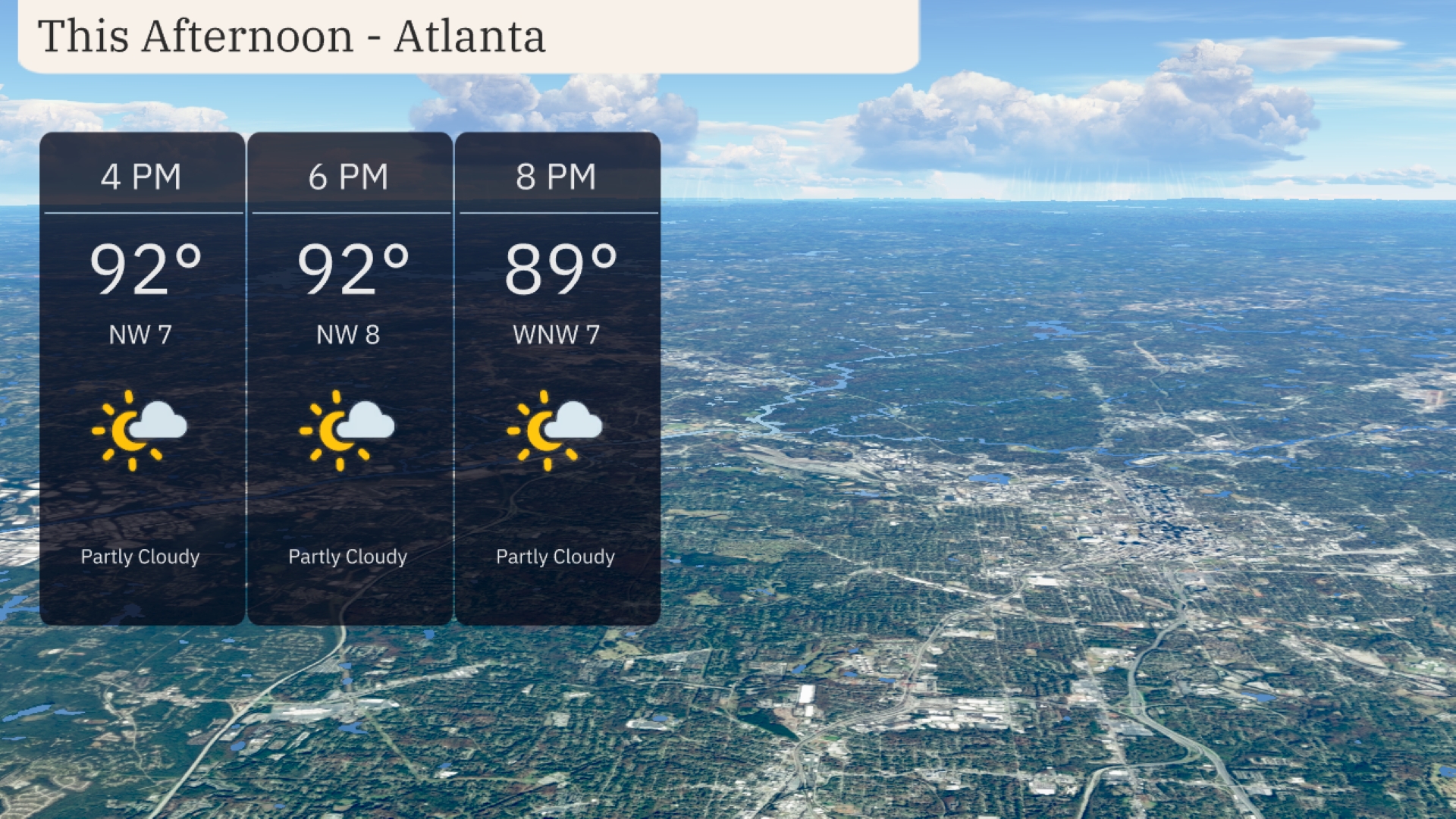
In Atlanta this afternoon, temperatures will be in the low 90s, peaking at 92 degrees by 4 PM and remaining steady through 6 PM. Expect partly cloudy skies with a northwest breeze around 7 to 8 miles per hour. As you move towards the evening, temperatures will slightly drop to 89 degrees by 8 PM, with winds shifting to the west-northwest at 7 miles per hour.
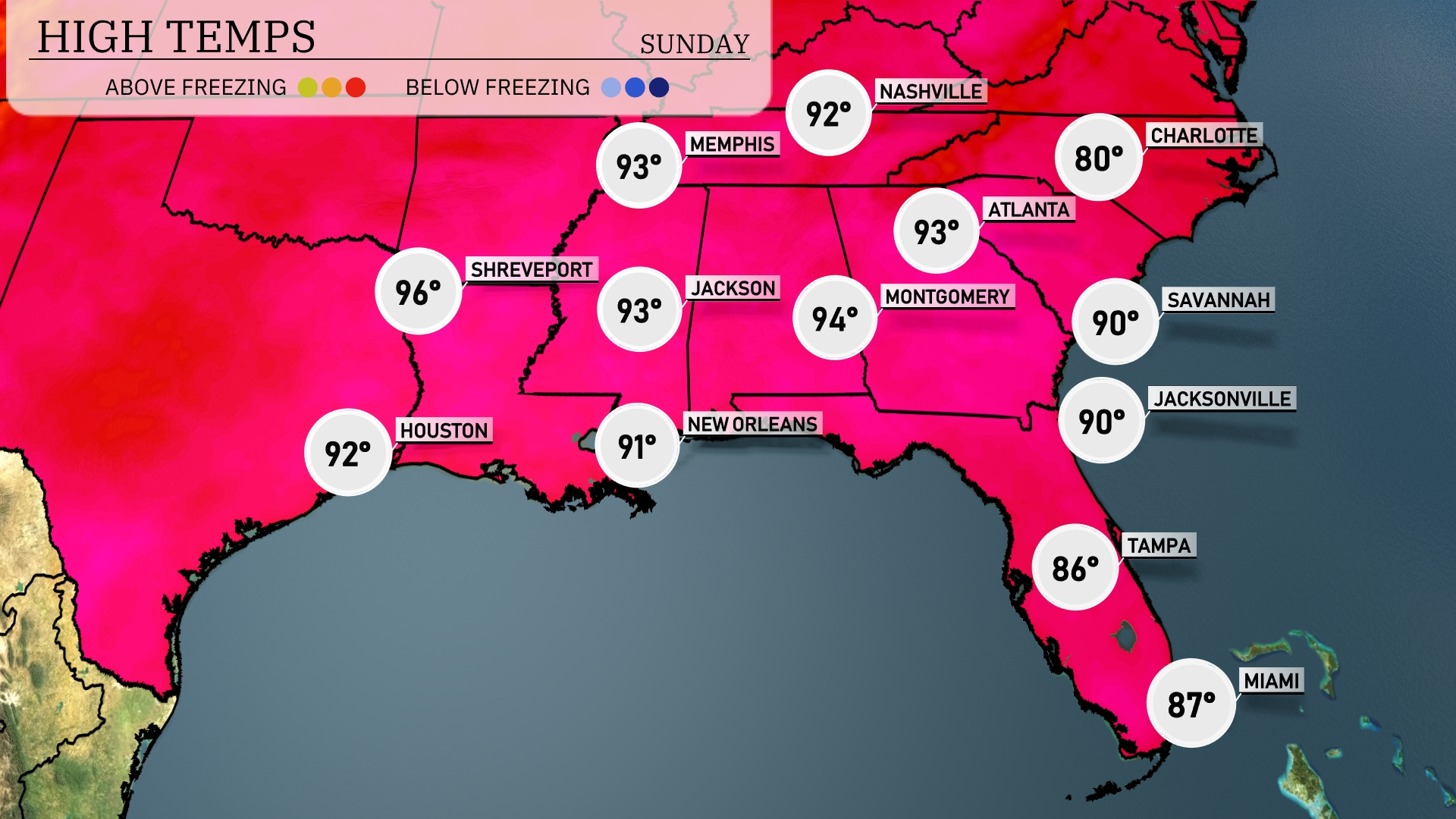
In the Southeast today, we’re tracking some warm temperatures. Shreveport leads with a sizzling high of 96 degrees, while Houston is close behind at 92. Over in New Orleans, expect a high of 91, and Atlanta will reach 93. Montgomery is also warm at 94 degrees, but cooler conditions can be found in Florida, with Tampa seeing a high of 86 and Miami at 87. It’s a classic summer day with notable warmth across the region.
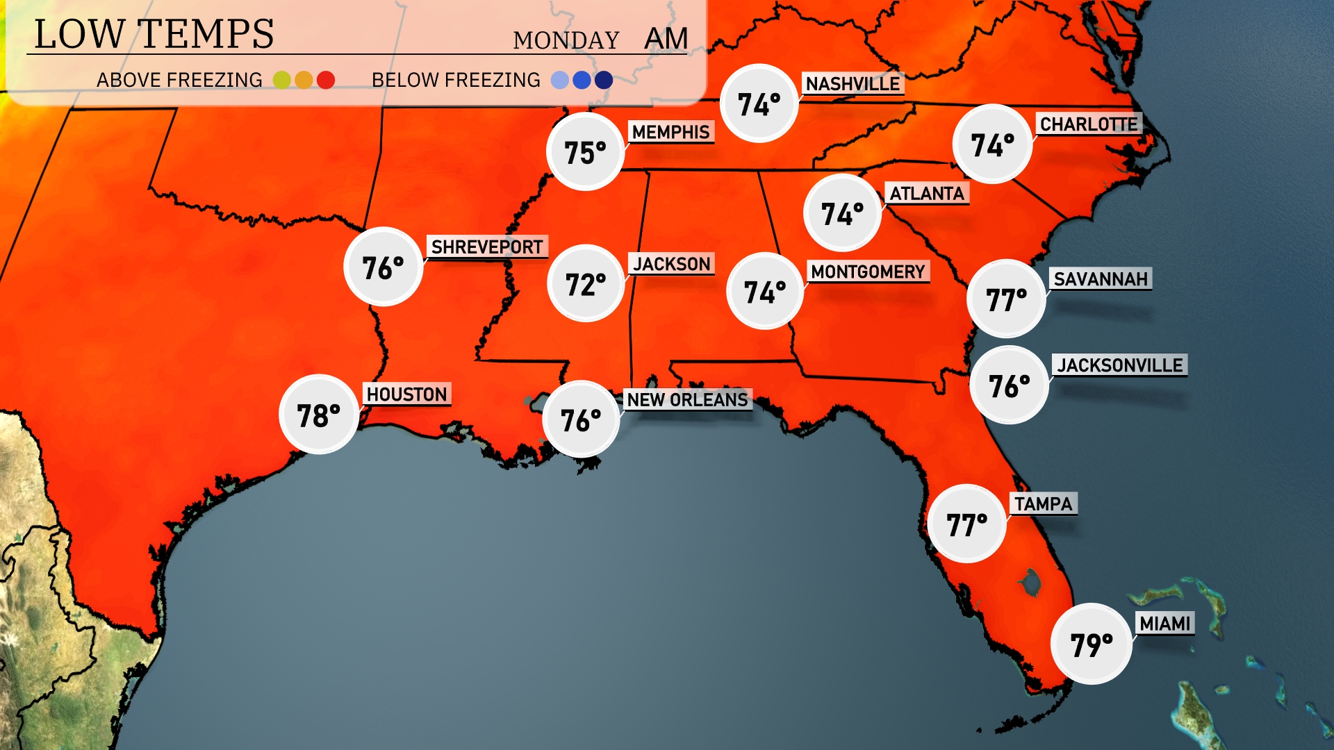
Tonight, temperatures are expected to drop to 72 degrees in Jackson. Memphis will see a low of 75. In Montgomery, expect a cool down to 74 degrees, while Atlanta also settles at 74. New Orleans remains warm with a low of 76, but expect Miami to stay warmer at 79 degrees.
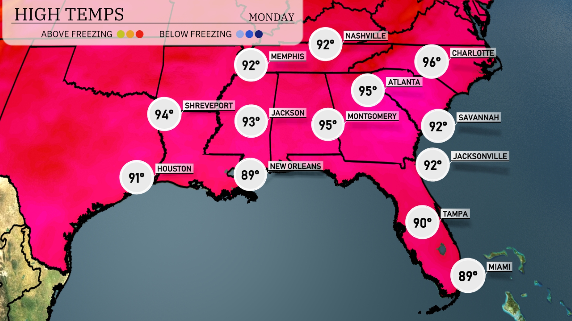
Tomorrow, high temperatures in the Southeast will be notably warm. Atlanta can expect a high of 95 degrees, while Memphis reaches 92. Montgomery will see similarly high temperatures at 95, making it a steamy day across the region. New Orleans will be slightly cooler at 89 degrees, while temperatures in Jacksonville and Savannah both hit 92. High readings across much of the Southeast reflect above-average temperatures, influenced by a strong ridge of high pressure.
The Southeast anticipates unsettled weather as a weak front brings scattered showers and thunderstorms from New Orleans to Atlanta starting Sunday night. Watch for isolated heavy downpours, particularly in areas like Jackson and Shreveport, creating brief localized flooding. Heading into Monday, the weather pattern remains active, with thunderstorms extending from Charlotte to Miami, driven by daytime heating. Temperatures stay warm, with highs ranging into the upper 80s, providing fuel for storms. Make sure to have your rain gear handy, especially in coastal areas where storm clouds linger.
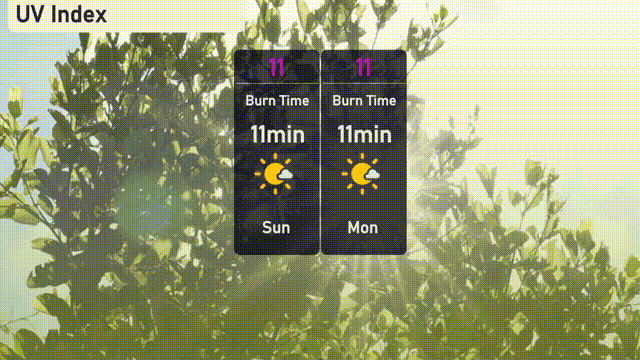
The UV index in Atlanta will reach an extreme level of 11 on both Sunday and Monday, with a potential burn time of just 11 minutes under direct sunlight. It’s crucial to limit sun exposure during peak hours and use high SPF sunscreen for protection. Stay sun-safe and enjoy the day with extra caution!