Weather on the Move: Your Week in Atlanta Unveiled
By
Amy Freeze
Dive into a comprehensive look at Atlanta's weather this week from mild afternoons to chilly nights and potential storms. Stay ahead with your trusted guide, Amy Freeze.
Get ready for a week of weather wonders in Atlanta! From sunny delights to evening breezes and a peek at potential downpours, we’re your go-to for daily updates!
Hello Atlanta residents! Meteorologist Amy Freeze here with a detailed look at your weather for the week. Enjoy clear skies and gentle temperatures early in the week, but don’t put away your umbrellas just yet — thunderstorms are on the horizon. Whether you’re planning your work week or arranging weekend outings, keep an eye on our daily updates and stay prepared for whatever the weather brings your way. Visit our detailed blog at https://amyfreeze.ai/ for more insights.
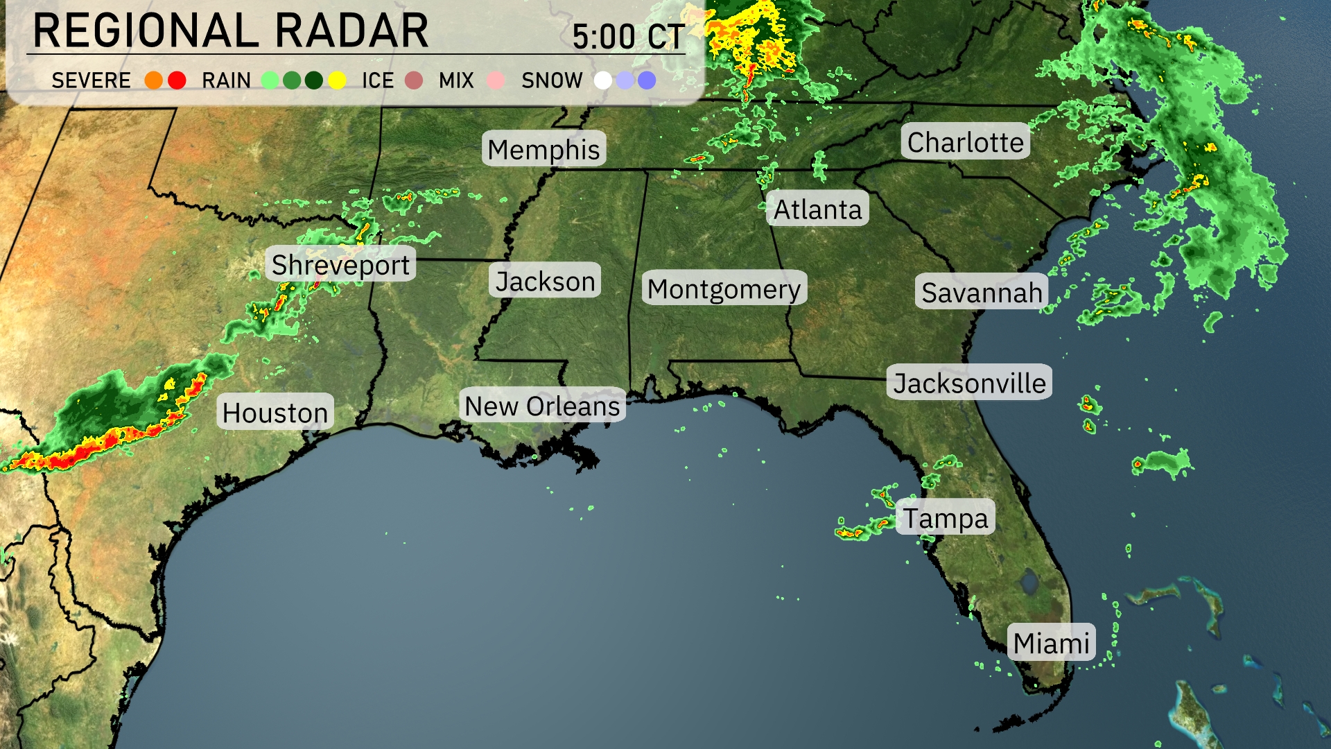
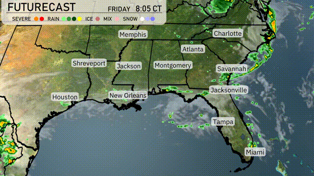
The Southeast region is currently experiencing scattered rain showers with the radar showing active weather patterns. In Texas, a line of strong storms is approaching Houston from the west, while Shreveport is already experiencing rain. Jackson is receiving lighter showers that are expected to drift towards Montgomery. The Carolinas, including Charlotte, are seeing increased precipitation and cloud cover as rain moves in from the northeast. Coastal cities like Miami and Tampa remain relatively dry, enjoying clear skies for now.
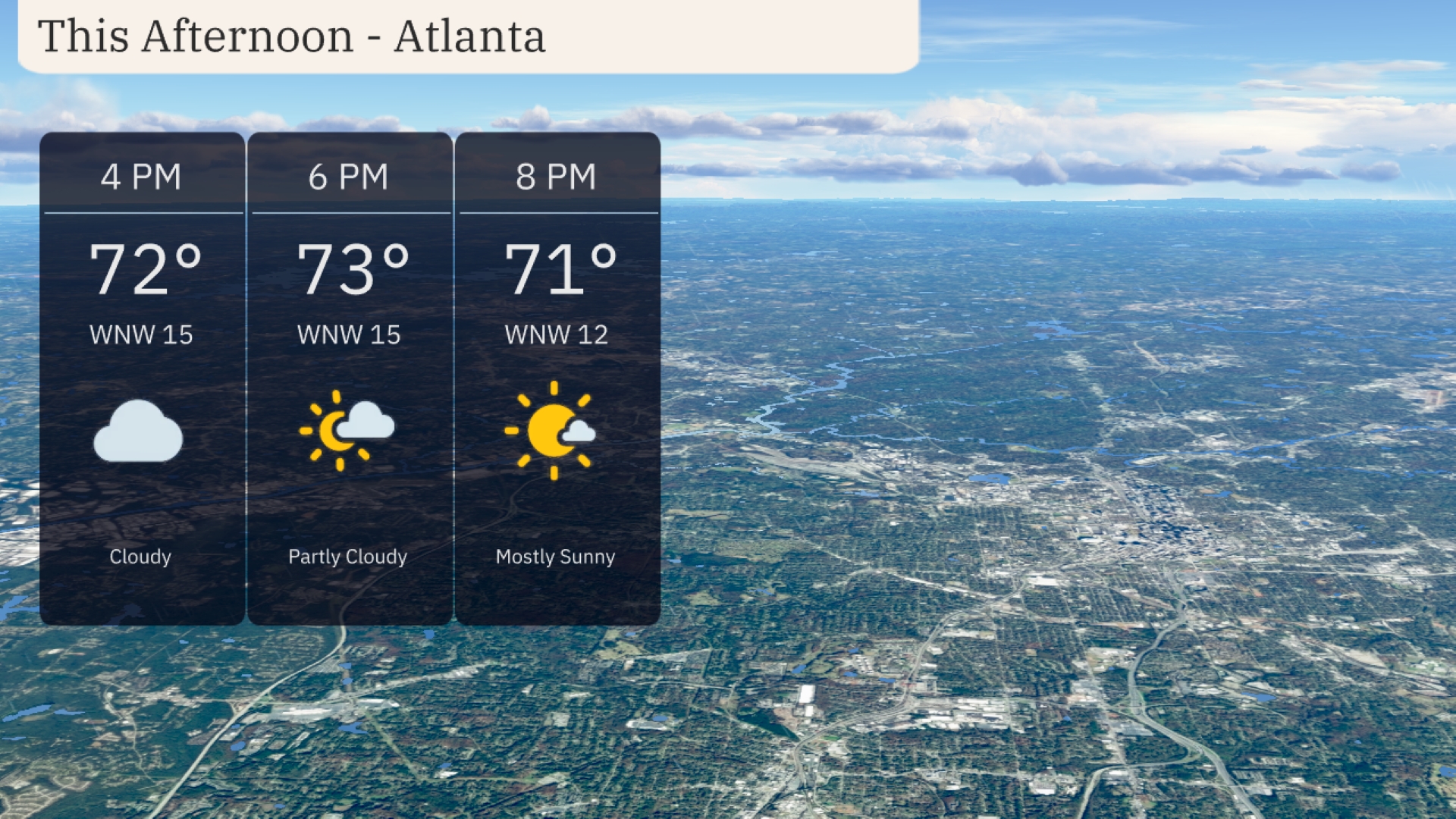
Afternoon in Atlanta features mild temperatures, peaking at 73 degrees by 6 PM. Winds are westerly at 15 miles per hour, offering a gentle breeze. Cloud cover will lessen as the afternoon progresses, moving from cloudy to mostly sunny by 8 PM.
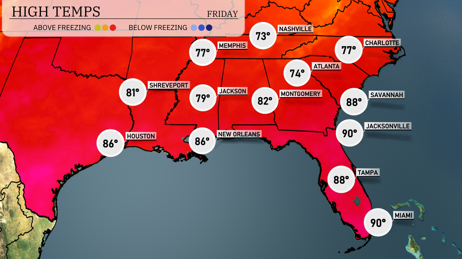
Today in Jacksonville, expect a hot high of 90 degrees, with similar conditions in Miami, also reaching 90. Savannah isn’t far behind, with a high of 88 degrees today. Moving inland, New Orleans will warm to 86, while Jackson sees a more moderate high of 79. Farther north, Atlanta will experience cooler conditions at 74 degrees, while Memphis will reach 77.
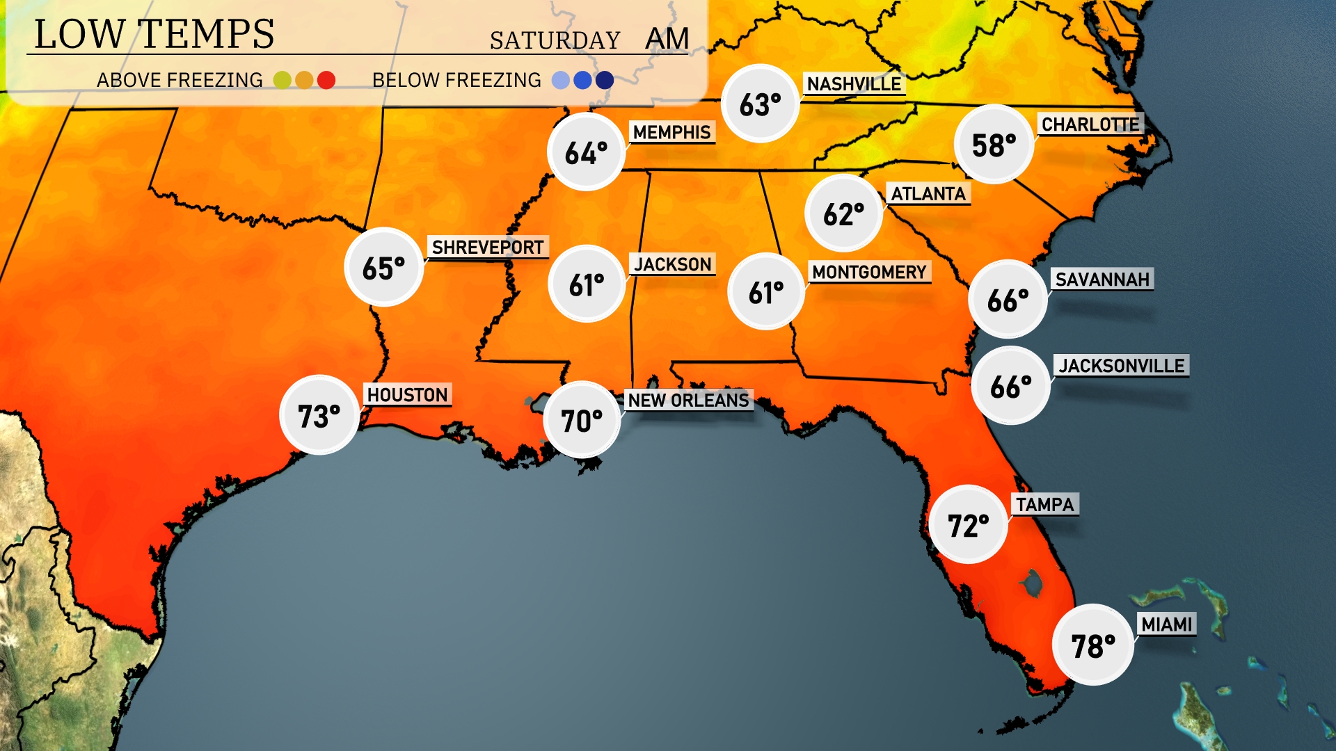
Tonight in the Southeast, we’re looking at some notably cool temperatures as the cold air settles in. Expect 61 degrees in Jackson, which may feel a bit brisk. Atlanta is forecasted to drop to 62, while Nashville will see a low of 63. The coastal areas are also feeling the chill, with Savannah at 66 and Jacksonville at the same. Miami stays mild at 78 degrees, but it’s significantly cooler than usual for the region.
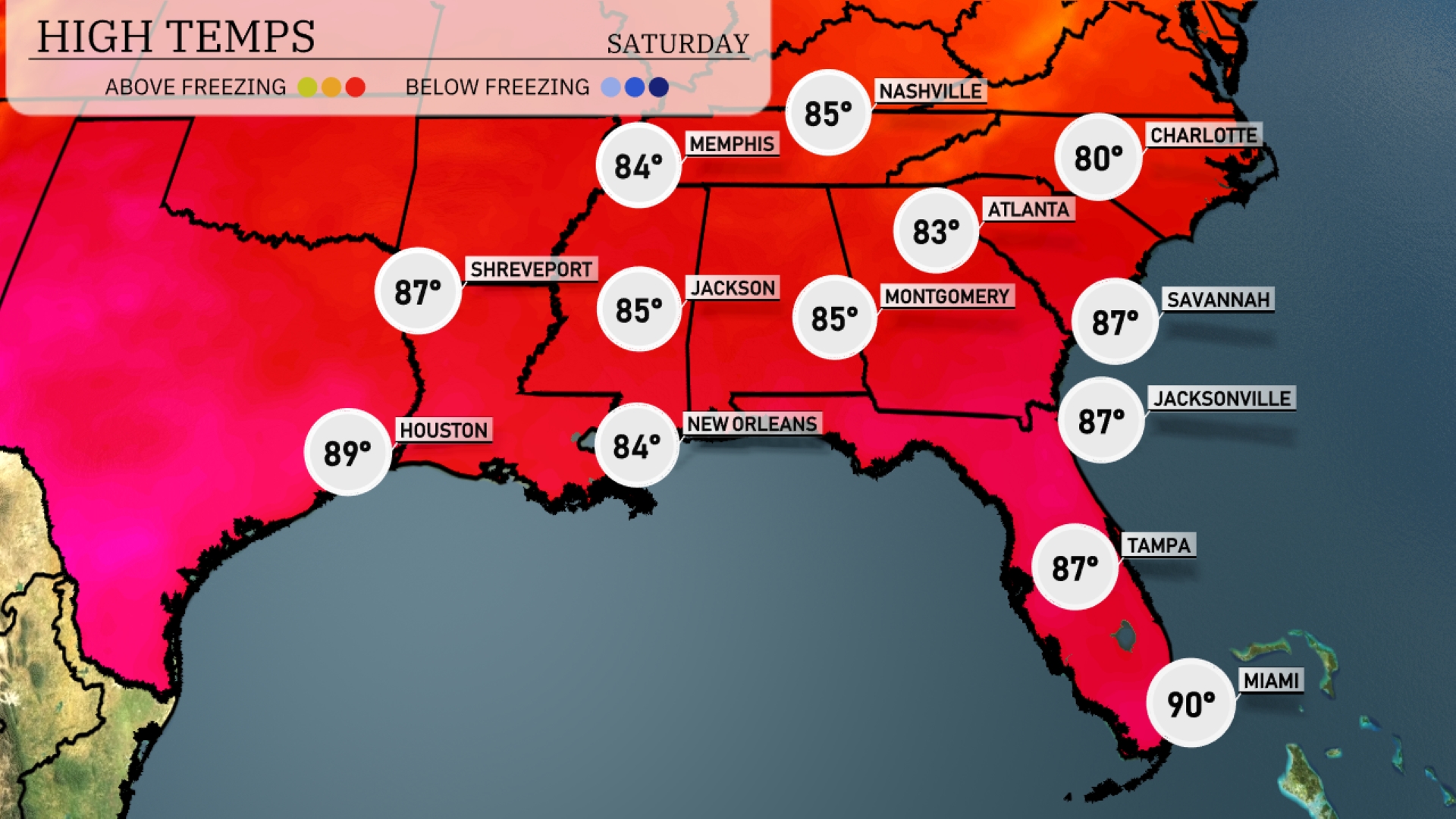
Tomorrow Miami leads the pack with a sweltering high of 90 degrees. Tampa and Jacksonville both reach 87 degrees, while Savannah will also see a warm 87. In the central area, New Orleans and Jackson will each peak at 84 and 85 degrees, respectively. Houston is on track for a hot 89 degrees, making for a steamy day throughout the region.
A strong cold front will push across the Southeast tomorrow, triggering widespread thunderstorms. Expect heavy rain and potential flash flooding, particularly across the Florida Panhandle and up into southeastern Alabama. The front will lead to cooler, drier air settling in behind it, with temperatures dropping by nearly 10 degrees by Thursday. Coastal areas from Savannah to Miami will see persistent showers, with chances of isolated severe thunderstorms along the immediate coast. Stay alert for flash flood alerts as rain accumulates rapidly, especially in low-lying regions.
The UV index in Atlanta will reach a 5 on Friday, indicating a moderate sun strength with a burn time of about 27 minutes. By Saturday, the UV index escalates to 10, which is very high, reducing the burn time to just 12 minutes in direct sunlight.