Explore a week of weather in Atlanta, from warm nights to severe thunderstorms, and how it compares to the rest of the Southeast.
This week in Atlanta, gear up for a mix of partly cloudy skies and potential thunderstorms. With temperatures fluctuating from the high 80s to mid-90s, it’s crucial to stay weather aware!
Welcome to our detailed forecast for Atlanta and the Southeast. As we navigate through the week, expect varying conditions from partly cloudy skies to imminent thunderstorms. We’ll provide insights into daily temperature variations, severe weather warnings, and safety tips to ensure you’re fully prepared for the week ahead. Plus, learn about the unique weather patterns affecting other cities in the Southeast and how they compare to Atlanta’s climate.
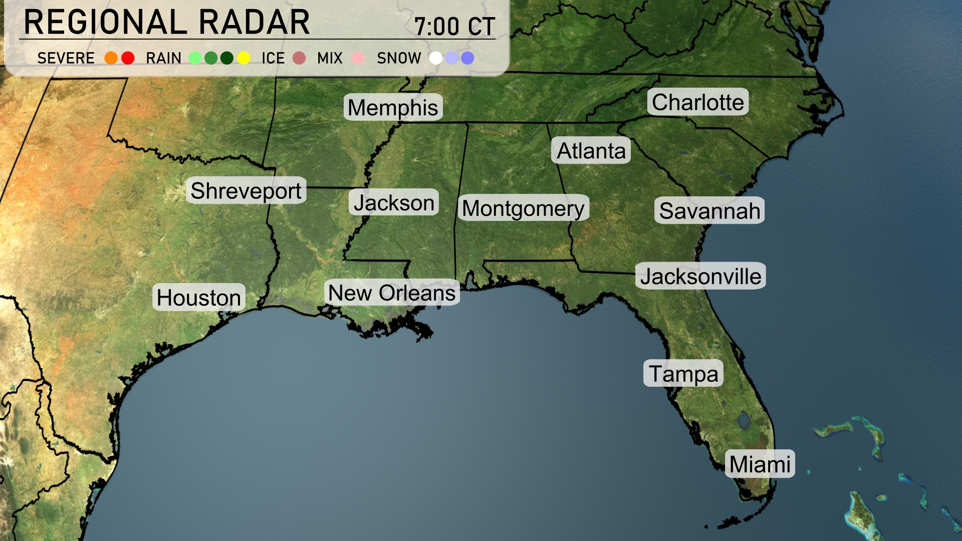
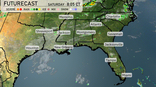
The regional radar for the Southeast shows some rain activity primarily across southern Georgia, including light showers near Savannah and Jacksonville. Atlanta and Montgomery remain under scattered cloud cover as rainheads develop in these areas. Over in the Gulf Coast, New Orleans is experiencing light rain while the skies over Miami and Tampa stay clear for now. Additionally, a significant thunderstorm is nearing Shreveport, anticipated to continue moving eastward.
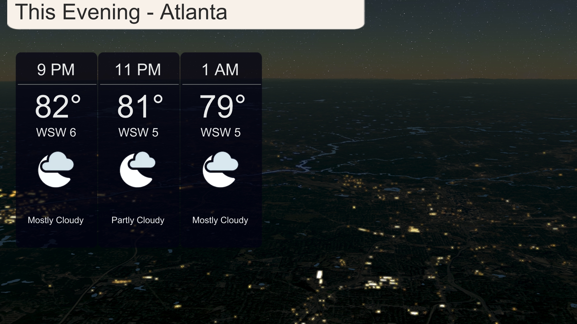
This evening in Atlanta, temperatures will begin at a warm 82 degrees at 9 PM, gradually dipping to 79 degrees by 1 AM. Winds are light, coming from the west-southwest at 5 to 6 miles per hour. Expect mostly cloudy skies, creating a mild and cozy atmosphere for any late-night activities.
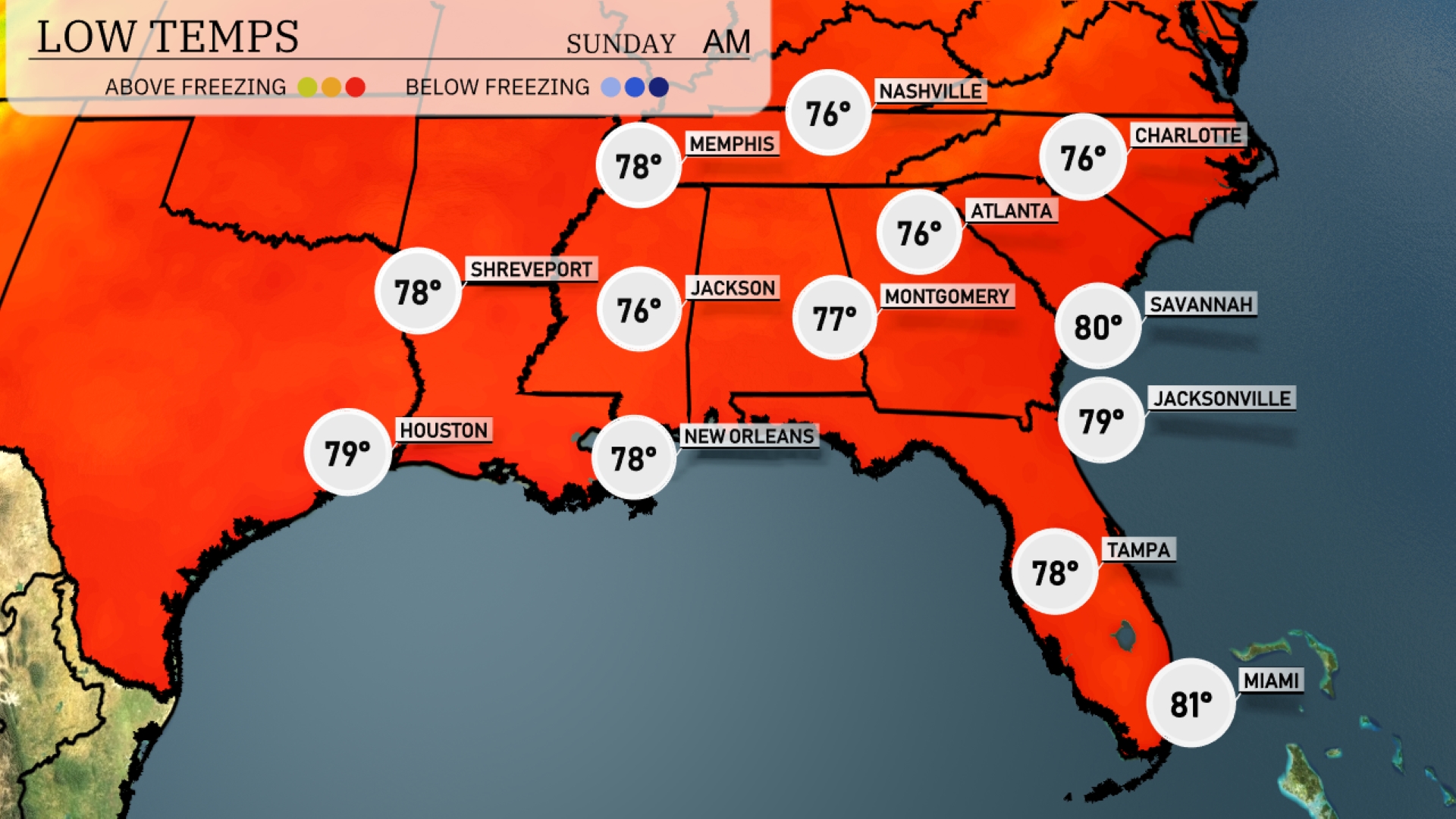
Tonight, Memphis will cool down to 76 degrees, while Nashville drops to 76 as well. Expect Jackson to reach a low of 76, and Montgomery will settle at 77 degrees. Further south, New Orleans will remain mild at 78 degrees, with Tampa not far behind at 78.
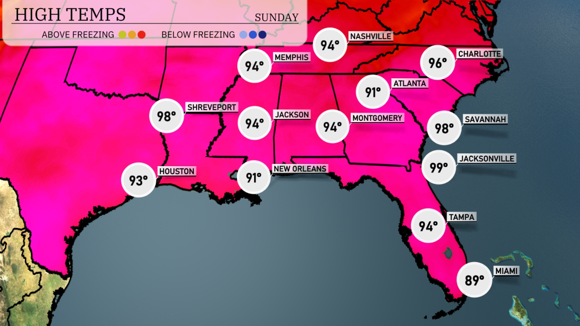
Tomorrow, high temperatures are soaring across the Southeast. Jacksonville will hit a sizzling 99 degrees, while Savannah isn’t far behind at 98. Atlanta is expected to reach a warm 91, and Montgomery will also see a high around 94 degrees. Memphis will have a high of 94, indicating a broad trend of above-average temperatures for the region. New Orleans will warm up to a comfortable 91 degrees, making for a warm day overall in the Southeast.
A cold front is pushing into the Southeast, bringing thunderstorms from Shreveport to Atlanta by late evening. Expect heavy rainfall and potential localized flooding in areas like Montgomery and Savannah. There’s a chance of severe weather, particularly in central Mississippi, where damaging winds are possible. Cooler air will follow the storms, ushering in drier conditions by Wednesday for most of the region. In contrast, Miami stays warm and sunny with temperatures holding steady in the upper 80s.
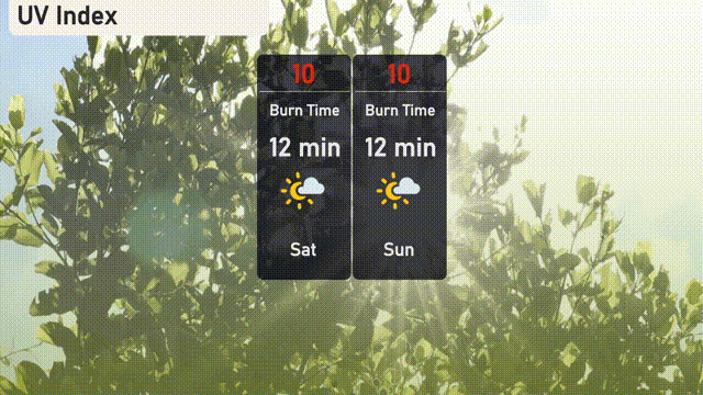
The UV index in Atlanta is very high at 10 this Saturday and Sunday, with a burn time of just 12 minutes in direct sunlight. Make sure to wear protective clothing, apply broad-spectrum sunscreen, and seek shade between 10 a.m. and 4 p.m. to protect yourself from sunburn.
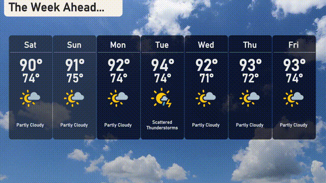
For the 7 Day Outlook in Atlanta:
Saturday: Anticipate partly cloudy skies with a high of 90 degrees and a low of 74 degrees.
Sunday: Partly cloudy conditions continue, with the temperature climbing to a high of 91 degrees, dipping to 75 degrees at night.
Monday: The sky remains partly cloudy, with the thermometer hitting a high of 92 degrees and a low of 74 degrees.
Tuesday: Watch for scattered thunderstorms, with temperatures reaching a steamy high of 94 degrees and settling to a low of 74 degrees.
Wednesday: Expect partly cloudy weather again, with a high of 92 degrees and a low of 71 degrees.
Thursday: Another day of partly cloudy skies, with temperatures peaking at 93 degrees and a low of 72 degrees.
Friday: Wrap up the week with partly cloudy conditions, a high of 93 degrees, and a low of 74 degrees.