Atlanta’s Weekly Weather Roundup: Sunny Starts and Stormy Surprises!
By
Amy Freeze
Catch up on everything from sunny forecasts to surprising storm alerts in Atlanta’s weather this week. Stay informed and prepared with our comprehensive guide!
This week in Atlanta promises a mix of mostly clear skies and stormy surprises. From a high of 95 degrees to expected showers. Check out our full forecast!
Your definitive guide to Atlanta’s weather this week is here! Expect a range of conditions from clear skies to thunderstorms, with temperatures peaking at 95 degrees. Important alerts on severe weather expected towards the end of the week, as a cold front brings thunderstorms and a drop in temperatures. Stay tuned for daily updates and protection tips against high UV indices. For an in-depth daily forecast, visit our blog at https://amyfreeze.ai/
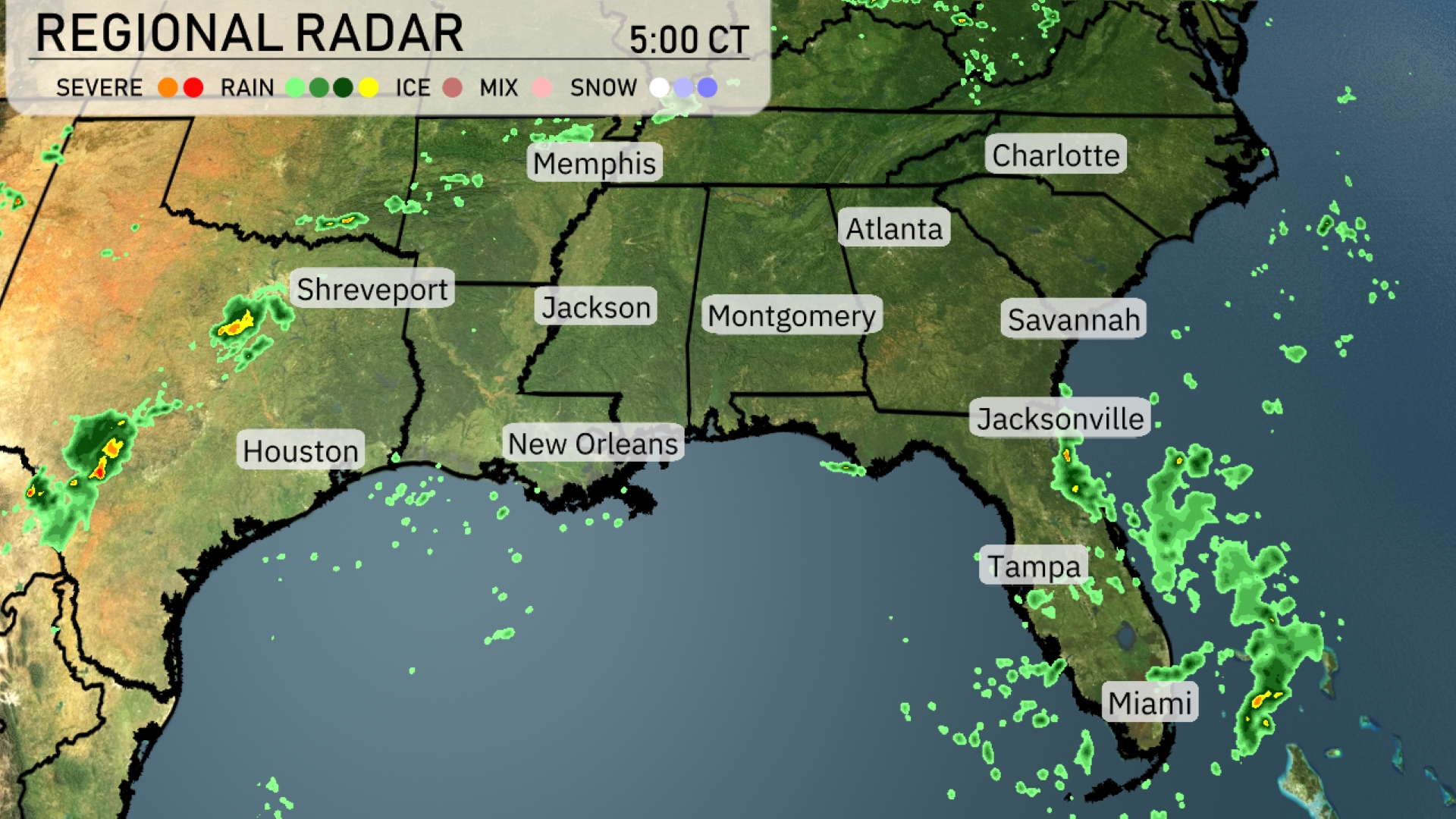
The Southeast is experiencing scattered showers along the Gulf Coast, particularly affecting New Orleans and Houston, with rain showers extending eastward towards Jacksonville and into the Florida Panhandle. Light rain persists near Savannah and the coastal regions of Georgia, while heavier pockets of precipitation are advancing towards Charlotte. Cloud cover is notable across the Mississippi and Alabama areas, with a few storms making their way towards Montgomery and Atlanta. Meanwhile, Shreveport experiences drier conditions with clear skies dominating the northern parts of the region.
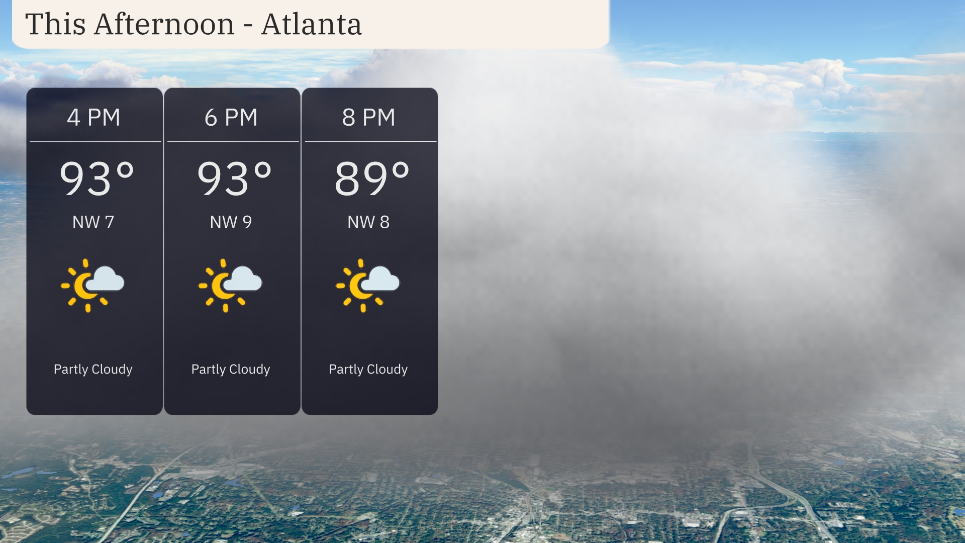
This afternoon in Atlanta, temperatures will reach up to 93 degrees with partly cloudy skies. Expect northwesterly winds around 7 to 9 miles per hour, providing a gentle breeze amid the warm weather. By 8 PM, temperatures will ease into the upper 80s, continuing the partly cloudy trend.
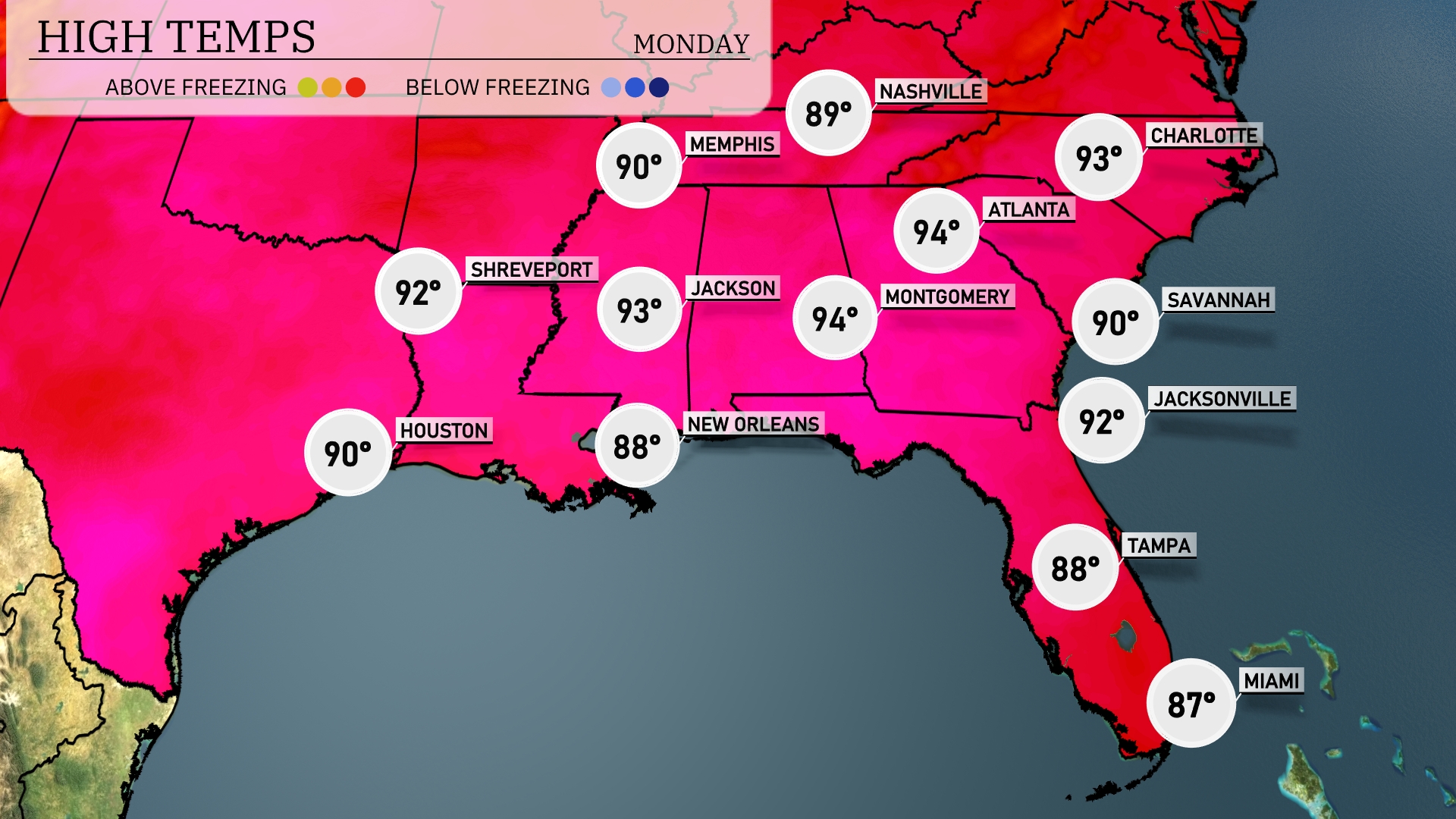
This afternoon, we’re seeing some toasty temperatures across the Southeast. In Montgomery, we’re expecting a high of 94 degrees, while Atlanta isn’t far behind at 93. Jacksonville will reach 92, and Savannah is also sitting at a warm 90 degrees. Over in New Orleans, the heat dips slightly with a high of 88, while Shreveport is forecasted to hit 92. Expect a mix of sunshine and humidity throughout the region today!
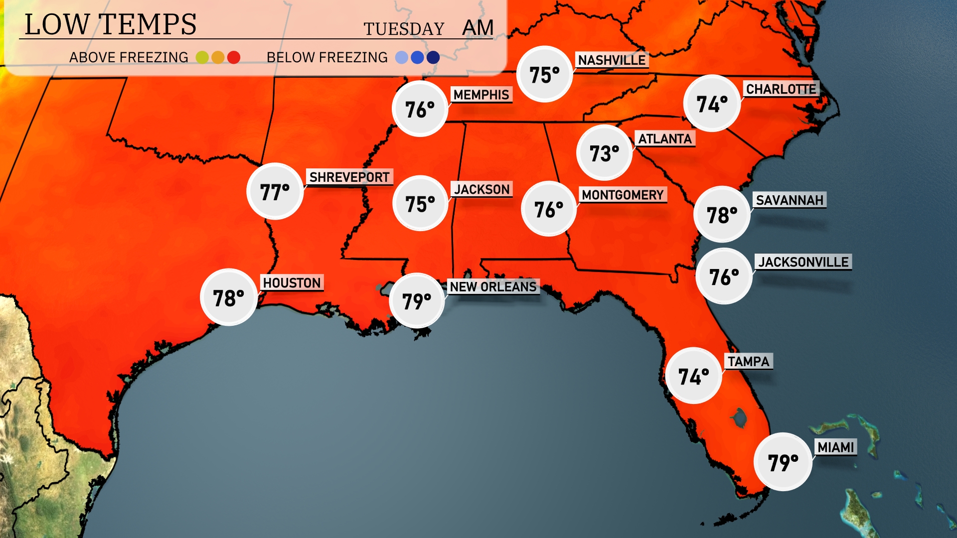
Tonight, Memphis will cool down to 75 degrees. Nashville will experience a low of 73 degrees. Expect cooler air in Jackson, dipping to 75 degrees, while Montgomery will see a low of 76. In the coastal areas, Tampa will settle at 74 degrees, with Miami remaining mild at 79 degrees.
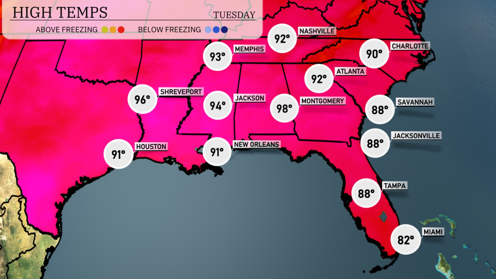
Tomorrow in the Southeast, Montgomery will be quite hot, reaching a sizzling 98 degrees. Atlanta is also in for a warm afternoon at 92 degrees, while Memphis will top out at 93 degrees. New Orleans will see highs around 91 degrees, just under the sweltering temperatures in nearby Jackson, which will reach 94 degrees. The overall trend indicates significantly above-average temperatures for this time of year across the region, influenced by a persistent heat dome.
A strong cold front is set to sweep through the Southeast tomorrow, bringing heavy rain and a chance of thunderstorms. Areas from Birmingham to Atlanta should be on alert for gusty winds and localized flooding, especially during the afternoon hours. Temperatures will drop significantly post-front, with cooler air settling in by evening. Jackson, Mississippi, and surrounding regions will see rain tapering off by late afternoon as the front moves eastward. Stay attentive to any severe weather alerts, as conditions can escalate with the approaching system.
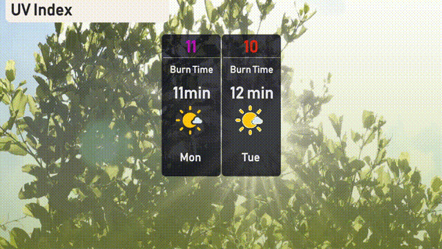
For your Monday in Atlanta, the UV index reaches a very high 11, with burn time possible in just 11 minutes, so take extra precautions if outdoors. Tuesday remains intense with a UV index of 10, shortening burn time slightly to 12 minutes. Consider seeking shade during peak sun hours and applying a high-SPF sunscreen to protect your skin!