Austin Evening Outlook: From Clear Skies to Storm Alerts
By
Amy Freeze
Explore how Austin’s weather transitions from serene clear skies to potential storm alerts. Stay ahead with our detailed forecast and safety tips.
Your latest Southern Plains Forecast update promises a mixed bag with clear skies and incoming storms across the region. Stay updated with our safety tips and weather predictions for the coming days.
In Austin, expect a tranquil evening as partly cloudy skies transition to clarity. However, the broader Southern Plains area faces variable weather, with temperatures soaring past seasonal averages and storm threats looming. For comprehensive daily insights and proactive weather preparedness, make sure to follow our updates and advice on coping with dramatic weather shifts.
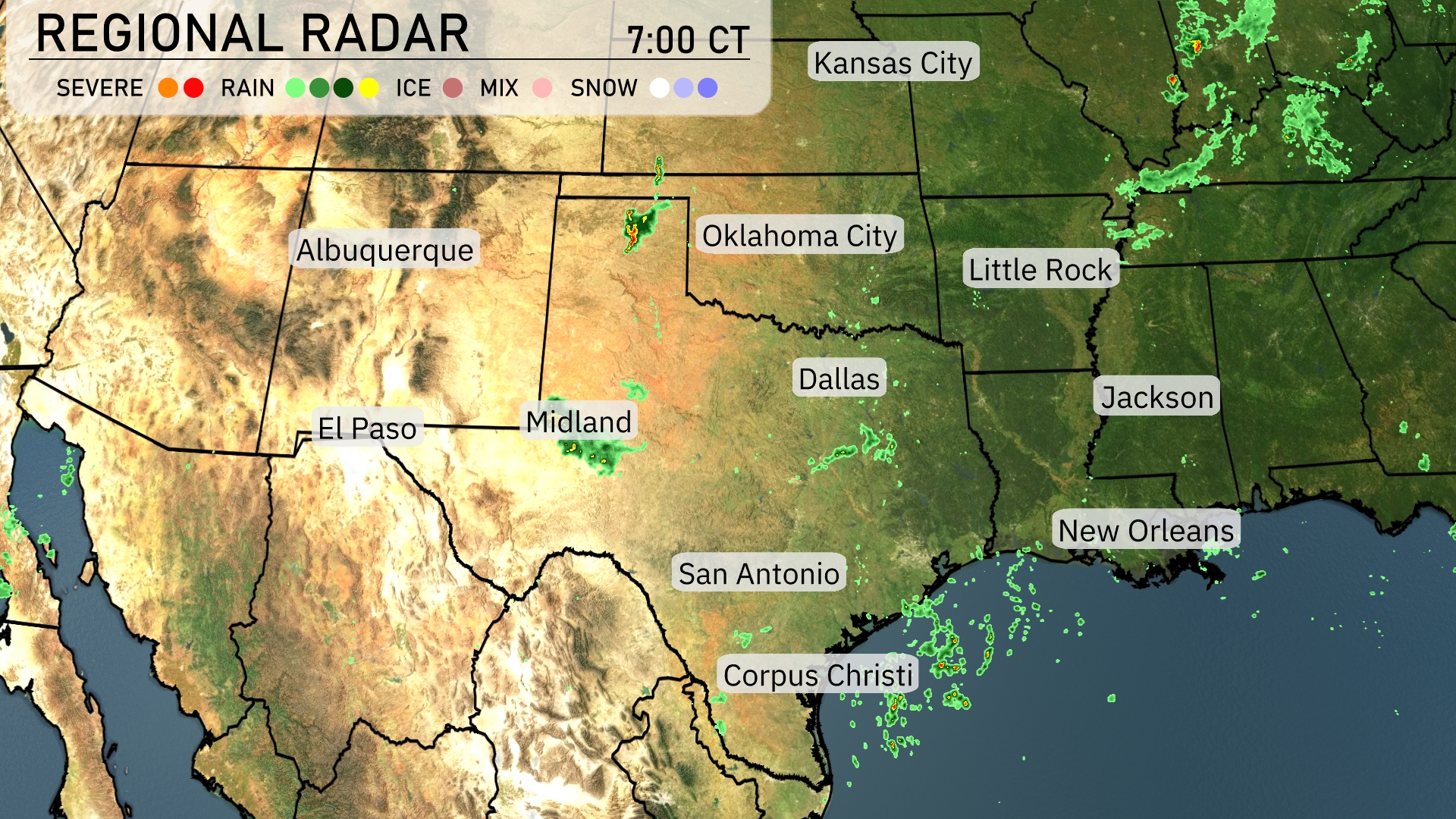
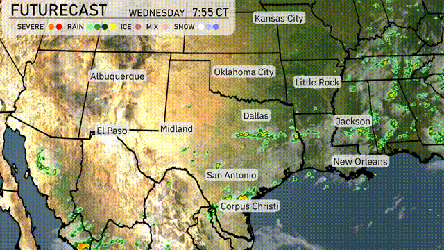
A line of scattered showers is making its way across southern Texas, stretching from San Antonio to Corpus Christi, with light rain moving into the Gulf. The Dallas-Fort Worth area is seeing some cloud cover, while Oklahoma City remains clear at this hour. Mid-Texas areas near Midland are experiencing spotty showers that could intensify. Little Rock and Jackson are presently clear, with storms later expected to head toward New Orleans.
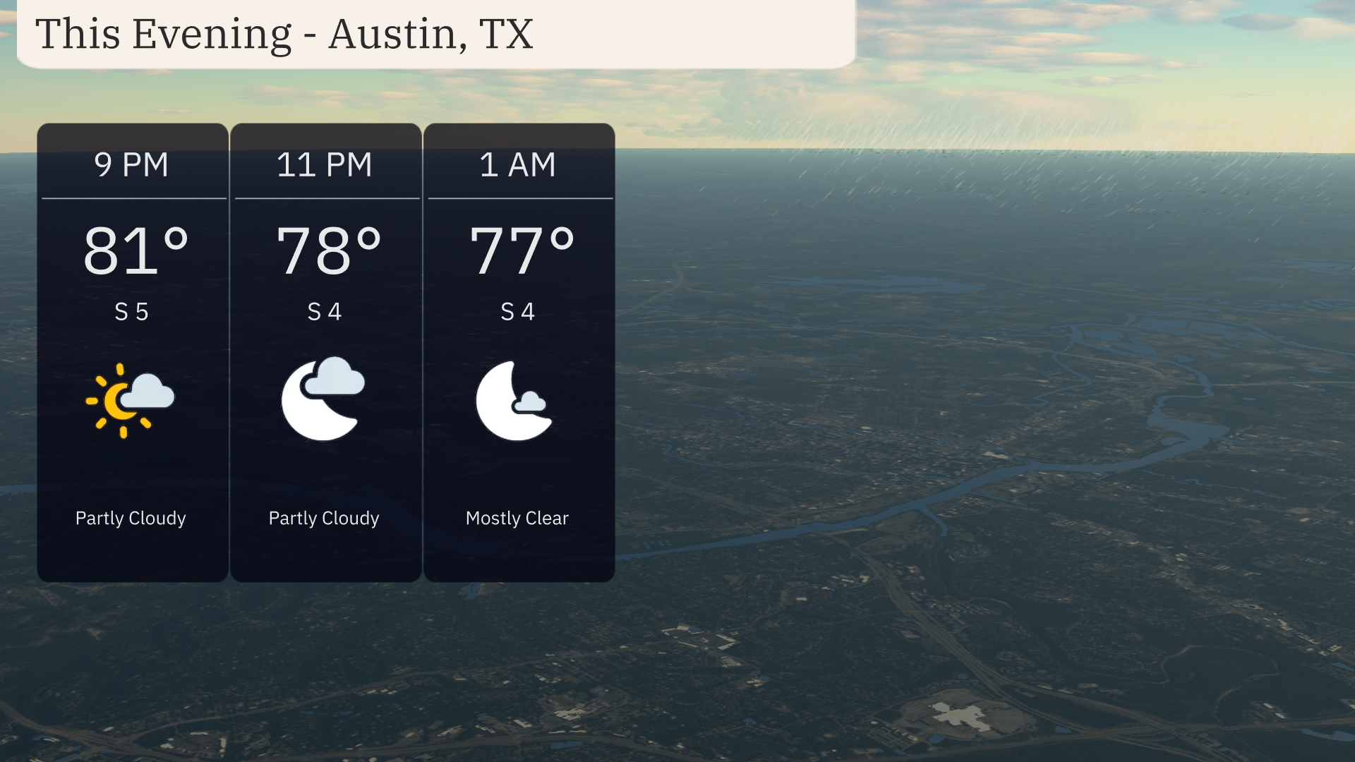
For this evening in Austin, expect partly cloudy skies transitioning to mostly clear overnight. Temperatures will gently drop from 81 degrees at 9 PM to 77 degrees by 1 AM. Winds are from the south at 5 mph initially, calming slightly to 4 mph as the evening progresses. A pleasant night ahead for any outdoor plans.
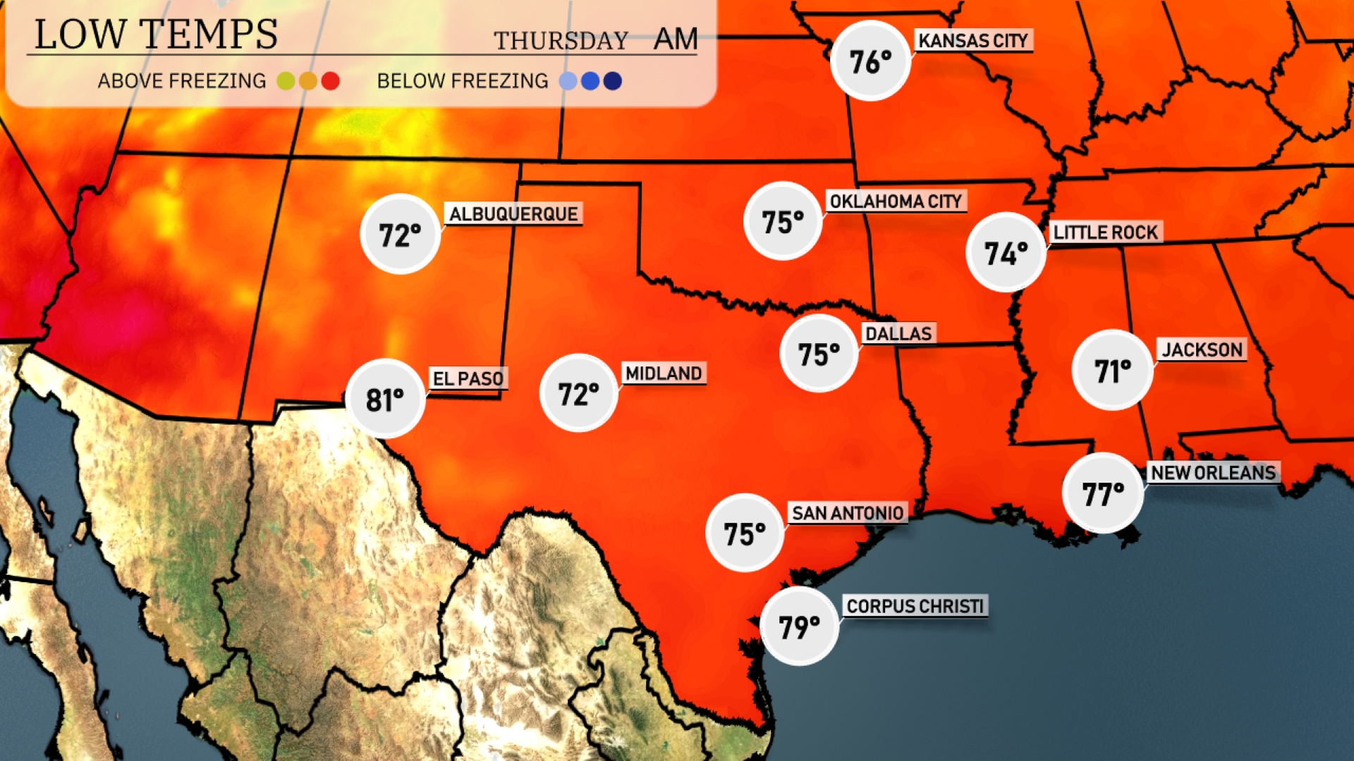
Tonight, the Southern Plains will experience some mild temperatures. Oklahoma City is expecting a low of 74 degrees, while Dallas will drop to 75. Little Rock will see a low of 74, and San Antonio is expected to cool down to 75 degrees. Meanwhile, New Orleans will hold steady at 77 degrees.
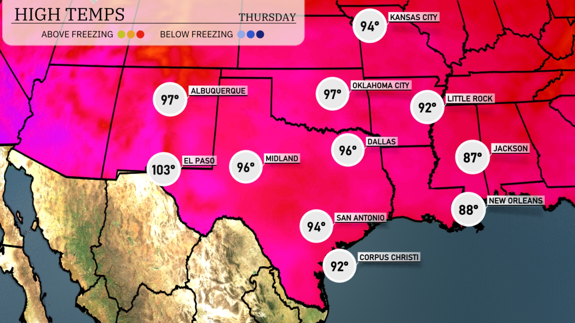
Tomorrow in El Paso, expect a sizzling high of 103 degrees, which is significantly above average for this time of year. Midland will see temperatures reach 96 degrees, also well above the norm. In San Antonio, afternoon highs will hit 94 degrees, while Dallas warms up to 96 degrees. Little Rock is expected to be milder at 92 degrees, slightly below average. The overall pattern indicates a warm air mass dominating the Southern Plains, leading to these elevated temperatures across the region.
Expect a significant weather shift in the Southern Plains as a cold front approaches. Showers and thunderstorms will persist from Oklahoma City down to Corpus Christi, with potential severe storms bringing strong winds and heavy rainfall. Wednesday morning may see some thunderstorms developing and moving east into Texas. Cooler temperatures will follow the frontal passage, providing a brief respite from summer heat. Stay cautious, especially in areas prone to flash flooding due to sudden downpours.
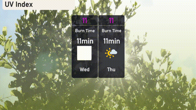
The UV index in Austin is set at 11 both Wednesday and Thursday, indicating an extreme level of solar radiation. With a burn time of just 11 minutes, it’s important to limit sun exposure, seek shade, and use broad-spectrum sunscreen. Stay sun-safe with protective clothing, hats, and sunglasses!
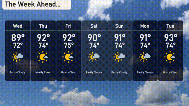
For the 7-day forecast in Austin:
Wednesday: Partly cloudy with a high of 89 degrees and a low of 72.
Thursday: The skies clear up, giving us a mostly sunny day with temperatures rising to 92 degrees, cooling to 74 at night.
Friday: Mostly clear with another warm day, reaching up to 92 degrees, with a low of 75.
Saturday: Partly cloudy skies with temperatures peaking at 90 degrees and dropping to 74 degrees overnight.
Sunday: Expect partly cloudy conditions, with the mercury hitting 91 degrees, cooling to 74 at night.
Monday: We continue with partly cloudy weather, the thermometer rising to 91 degrees once more and dipping to 74 by nightfall.
Tuesday: The week rounds out mostly clear, with a high of 93 degrees and lows around 74.
Hope that helps! Stay comfortable during those warm days!