Morning Moods: Austin’s Weather Outlook & Regional Updates
By
Amy Freeze
Explore the dynamic weather patterns from Austin to El Paso with insights on temperatures, storms, and sunny forecasts in the Southern Plains.
Tomorrow’s forecast for Austin calls for a partly cloudy morning transitioning to a sunny day, with extensive coverage on regional weather across the Southern Plains.
Welcome to your local weather update! As Austin greets the day with partly cloudy skies, you’ll experience a mild morning turning warmer by midday. Meanwhile, surrounding areas like El Paso are experiencing intense heat, while Oklahoma City prepares for potential storms. This blog delves into the intricate details of the shifting weather across the Southern Plains, ensuring you stay informed. To stay ahead of the weather’s whims, check our full forecasts at https://amyfreeze.ai/
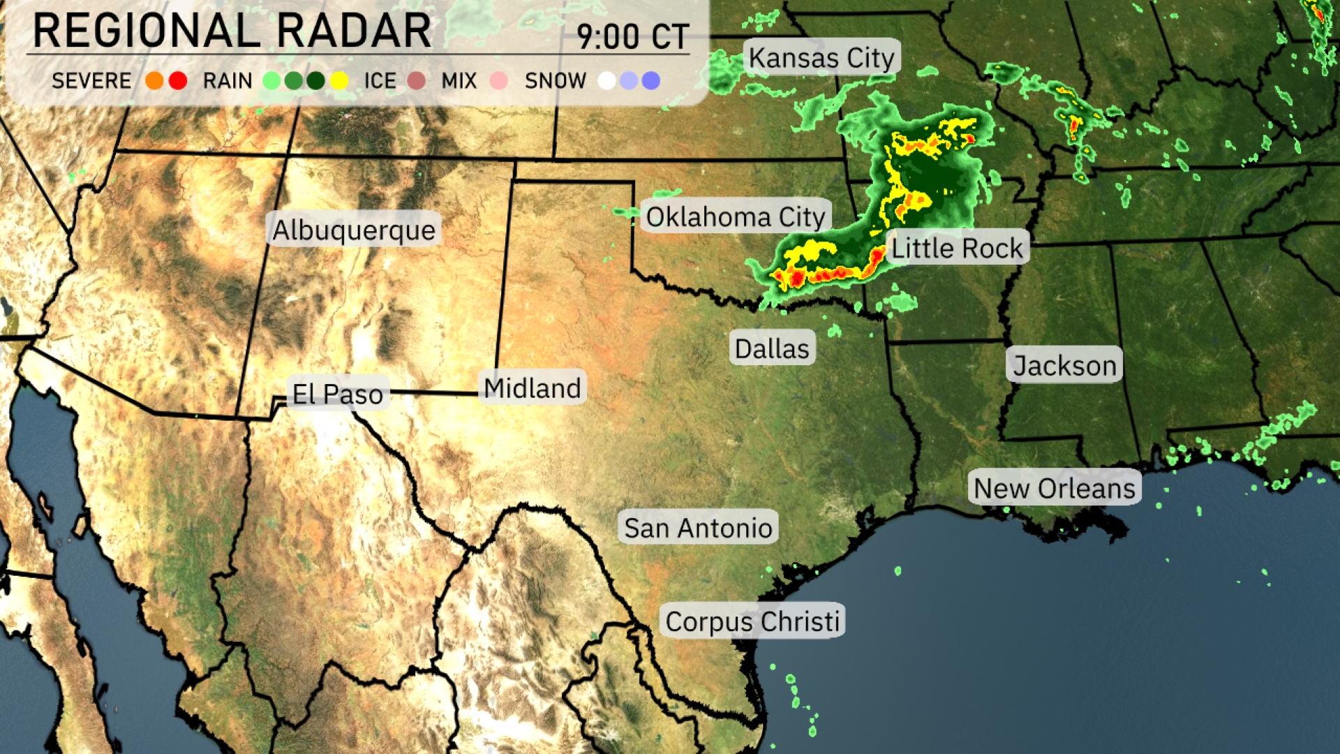
On the Regional Radar, a batch of storms is located over northeastern Oklahoma and is tracking towards Little Rock, Arkansas, bringing considerable rainfall and some severe weather elements. For areas like Kansas City, the skies remain largely clear, while Oklahoma City, which recently saw storms, is now experiencing lighter showers. Southern parts of this wide region, including Dallas and San Antonio, remain dry under partly cloudy conditions. Areas west towards Albuquerque and El Paso are enjoying clear skies today.
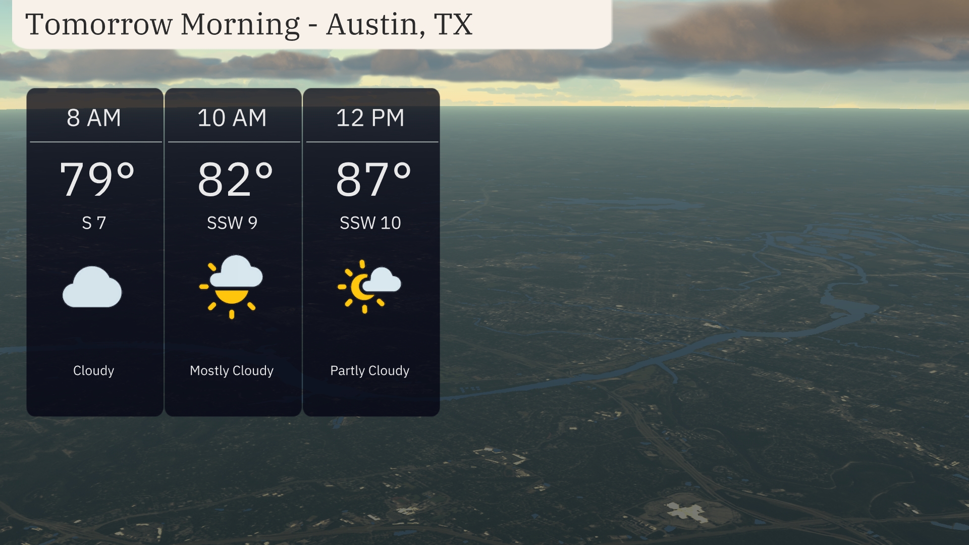
Start your Friday in Austin with temperatures around 79 degrees at 8 AM, rising to 82 degrees by 10 AM. Expect a mostly cloudy morning with winds shifting from the south at 7 mph to the south-southwest at 9 mph. By midday, clouds begin to clear, leading to partly cloudy conditions with a temperature nearing 87 degrees, and winds increasing slightly to 10 mph from the south-southwest.
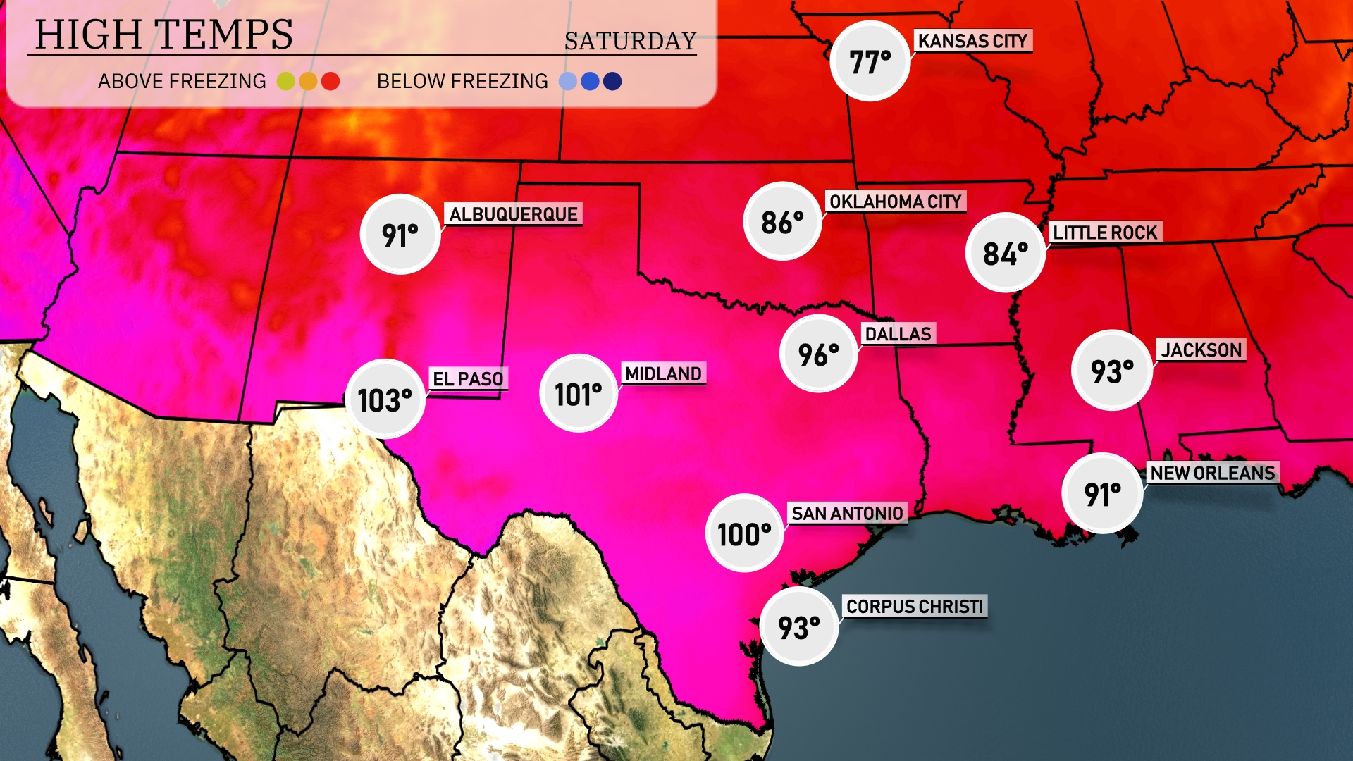
Tomorrow in El Paso, expect a scorching high of 103 degrees. Midland will also be hot, reaching 101 degrees, while San Antonio is forecasted to hit a sizzling 100. Dallas is slightly cooler at 96 degrees, and Corpus Christi will enjoy a warm high of 93.
A dynamic weather pattern is setting up for the Southern Plains with the approach of a cold front. Expect rain showers from Dallas to Corpus Christi, offering some welcome relief from dry conditions. Oklahoma City is under the radar for stronger storms, with potential severe weather, including gusty winds, likely as the unstable air mass interacts with the front. Be weather aware in the southeast region tonight through Wednesday night as storm warnings could be issued.
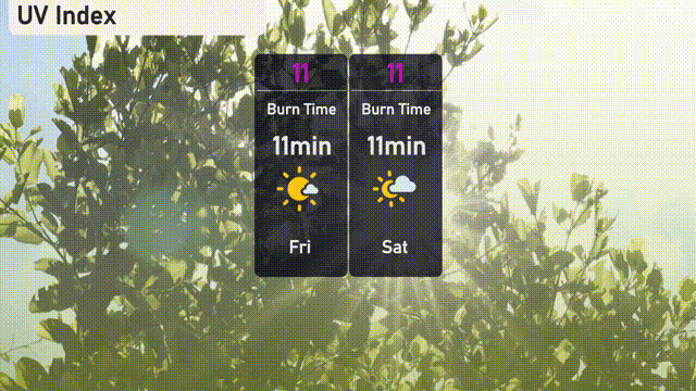
The UV index in Austin is a very high 11, with direct sun exposure causing burns in approximately 11 minutes!
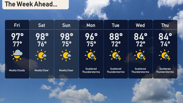
Friday: Mostly cloudy with a high of 97 degrees and a low of 77 degrees.
Saturday: Expect clear skies with a warm high of 98 degrees, dropping to 76 degrees at night.
Sunday: Another clear day with highs reaching 98 degrees and a nighttime low of 75 degrees.
Monday: Brace for scattered thunderstorms as temperatures hit 96 degrees in the afternoon with a low of 75 degrees.
Tuesday: Scattered thunderstorms continue with a high of 88 degrees and a low of 72 degrees.
Wednesday: Look for scattered thunderstorms sticking around, highs of 84 degrees and lows near 72 degrees.
Thursday: More thunderstorms are expected with a high of 84 degrees and a low of 74 degrees.