Shifting Skies: Austin’s Vibrant Weather from Dawn to Dusk
By
Amy Freeze
Tomorrow’s forecast in Austin brings a mix of mostly cloudy skies in the morning with a climb to sunny spells by noon. However, keep your umbrellas handy as storm activity across the Southern Plains could bring changes.
This morning in Austin is set to kick off with mostly clear skies, but keep an eye on the horizon as conditions in the Southern Plains might spice things up with storms. Stay prepared!
Greetings, Austin residents and visitors! Get ready for a day starting with clear skies and evolving into a complex weather pattern. By midday, temperatures will rise under partly cloudy conditions, reflective of a common Southern Plains day. However, our regional radar indicates moving storm fronts possibly affecting the area. Detailed forecasts expect noteworthy temperature peaks and storm activities over the next week. Stay tuned and prepared with daily updates available on our blog.
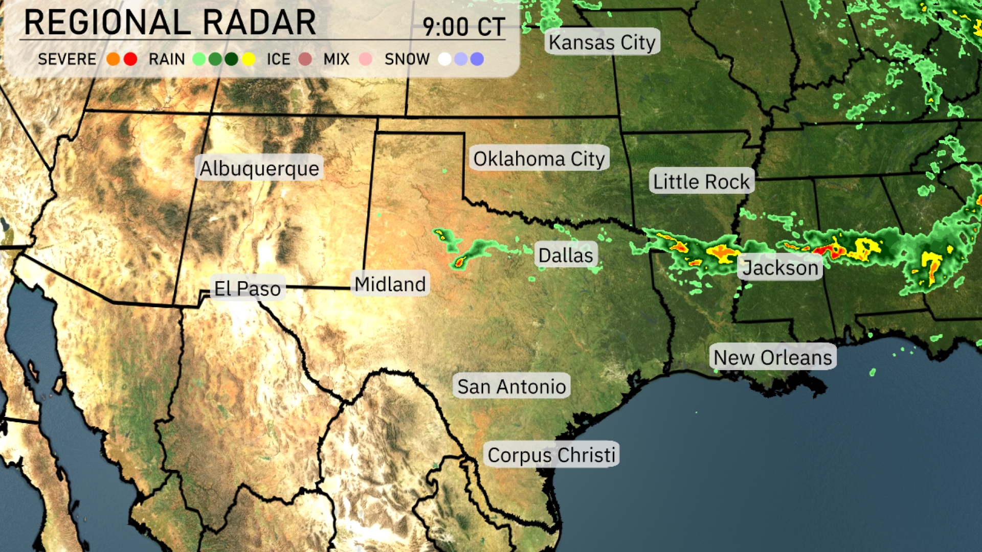
On the Regional Radar, the Southern Plains show some storm activity, notably with a line of rain moving eastward through Dallas towards Jackson. This system is expected to progress, bringing precipitation to parts of eastern Texas and into Louisiana. Oklahoma City and the surrounding areas remain clear, offering a reprieve from rain. Elsewhere, light precipitation is developing along the southern Colorado border, though much of the region enjoys calm and dry conditions currently.
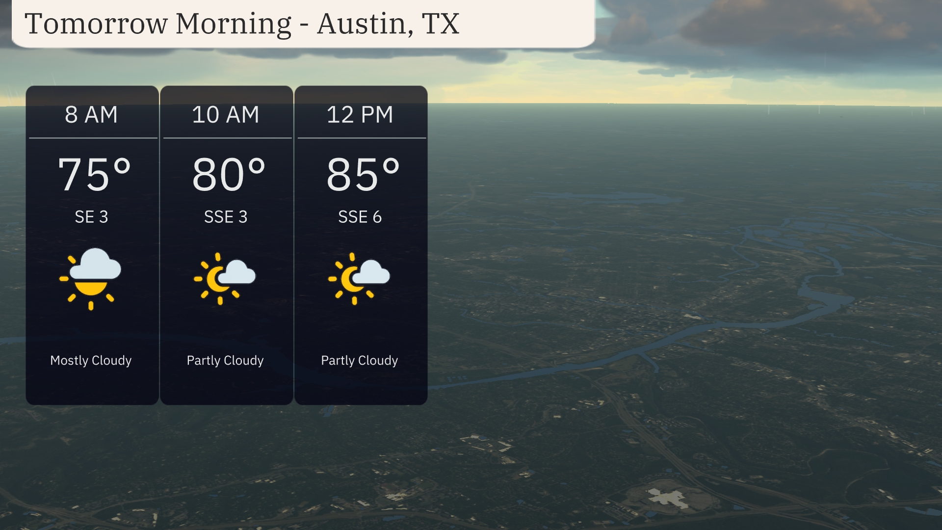
Austin’s weather for tomorrow morning begins mostly cloudy at 8 AM with temperatures at 75 degrees and a southeast wind at 3 mph. By 10 AM, expect partly cloudy skies as temperatures climb to 80 degrees with a south-southeast breeze at 5 mph. The morning wraps up at noon, warming up to 85 degrees under partly cloudy skies with a light south-southeast wind at 6 mph.
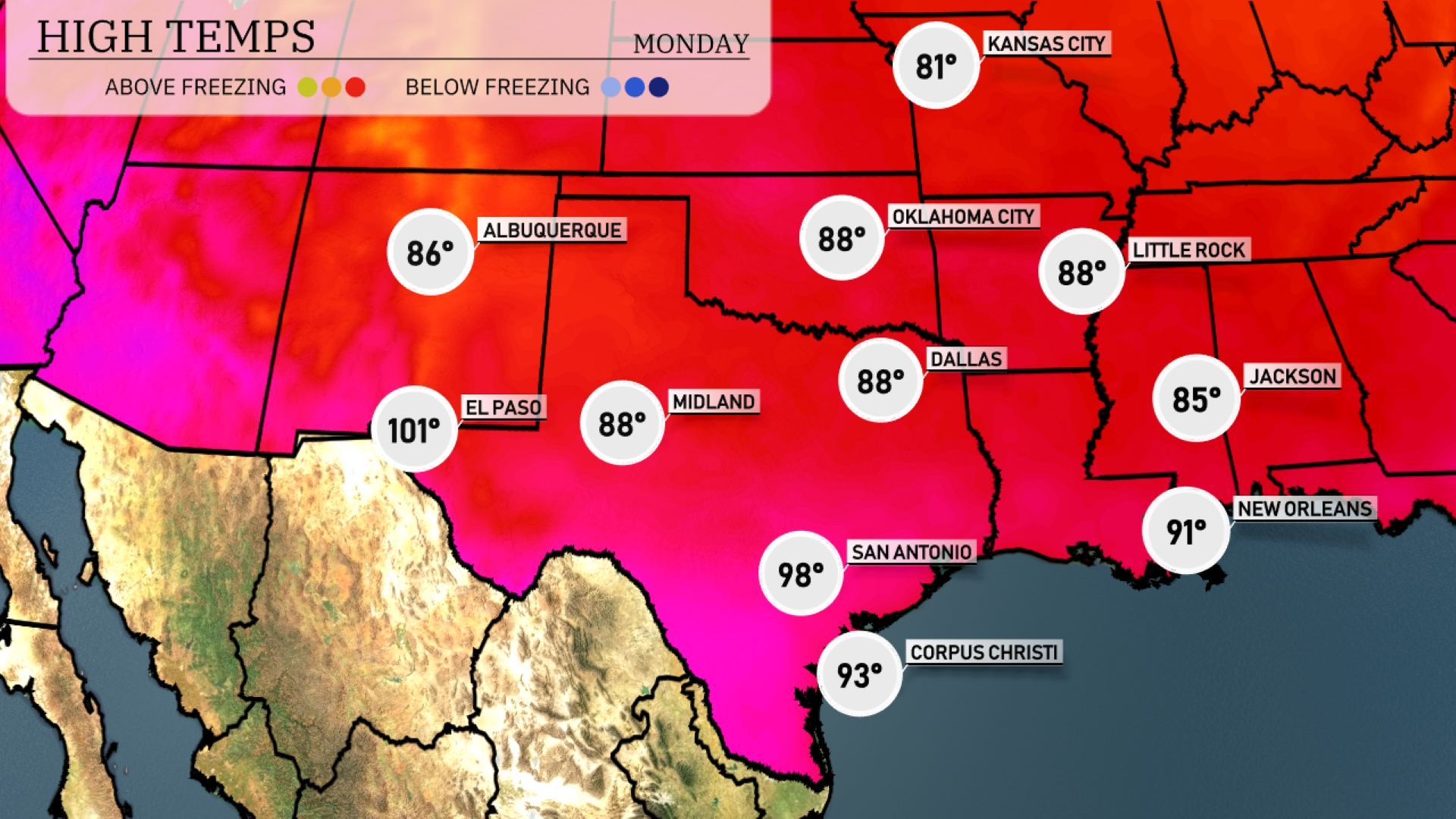
Tomorrow in El Paso, expect a sizzling high of 101 degrees. Midland is forecasted to reach 88 degrees, while Dallas will also see a high of 88. In San Antonio, temperatures will soar to a warm 98 degrees. Corpus Christi is looking at a high of 93, and New Orleans isn’t far behind, expecting 91 degrees.
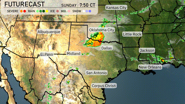
A cold front is set to move through the Southern Plains, bringing significant weather changes. Tomorrow, expect rain and thunderstorms from Dallas to Corpus Christi, offering much-needed moisture. Oklahoma City should remain vigilant as stronger storms are likely. With a potent combination of an unstable air mass and an advancing cold front, severe weather warnings could be issued across southeastern areas through Tuesday night.
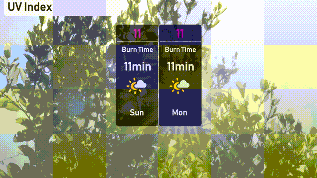
In Austin, the UV index is expected to reach 11 today and tomorrow, indicating an extreme level of sun exposure. With a burn time of just 11 minutes.
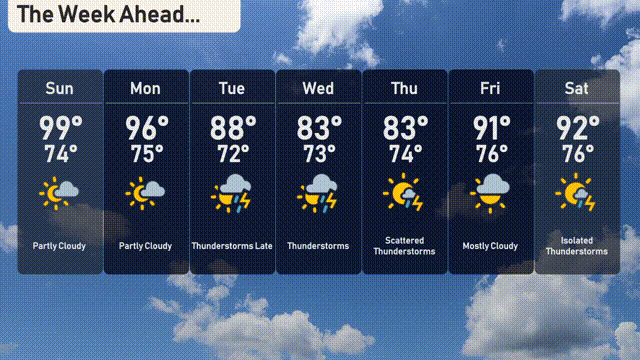
The 7 day forecast for Austin:
Sunday: Partly cloudy with a high of 99 degrees and a low of 74 degrees.
Monday: Another partly cloudy day with temperatures reaching 96 degrees and dipping to 75 degrees overnight.
Tuesday: Thunderstorms are expected late, with a high of 88 degrees and a mild low of 72 degrees.
Wednesday: More thunderstorms to come, bringing temperatures down to a high of 83 degrees, with a low of 73 degrees.
Thursday: Scattered thunderstorms throughout the day, with highs around 83 degrees and lows at 74 degrees.
Friday: Mostly cloudy with a high reaching up to 91 degrees and a low of 76 degrees.
Saturday: Isolated thunderstorms to round out the week, with a daytime high of 92 degrees and a nighttime low of 76 degrees.