Austin Evening Scoop: Skies Clearing for Stars, Southern Plains Bracing for Storms
By
Amy Freeze
Explore the dynamic weather landscape of Austin and the Southern Plains, from serene starry nights to impending stormy encounters. Stay informed and prepared with our latest update.
Tonight’s Austin skies offer perfection for stargazers, while the Southern Plains brace for stormy conditions. Click for full details!
As we delve into the weather for Austin and the surrounding areas, clear skies this evening offer a prime opportunity for stargazing or late-night walks. However, the weather narrative shifts as we anticipate scattered showers and potential severe storms in the Southern Plains. Stay updated with our comprehensive daily and weekly forecasts, ensuring you’re always prepared. Read our full report on today’s extremes from sizzling temperatures to storm warnings. Stay safe and stay informed with insights from your trusted local meteorologist, Amy Freeze.
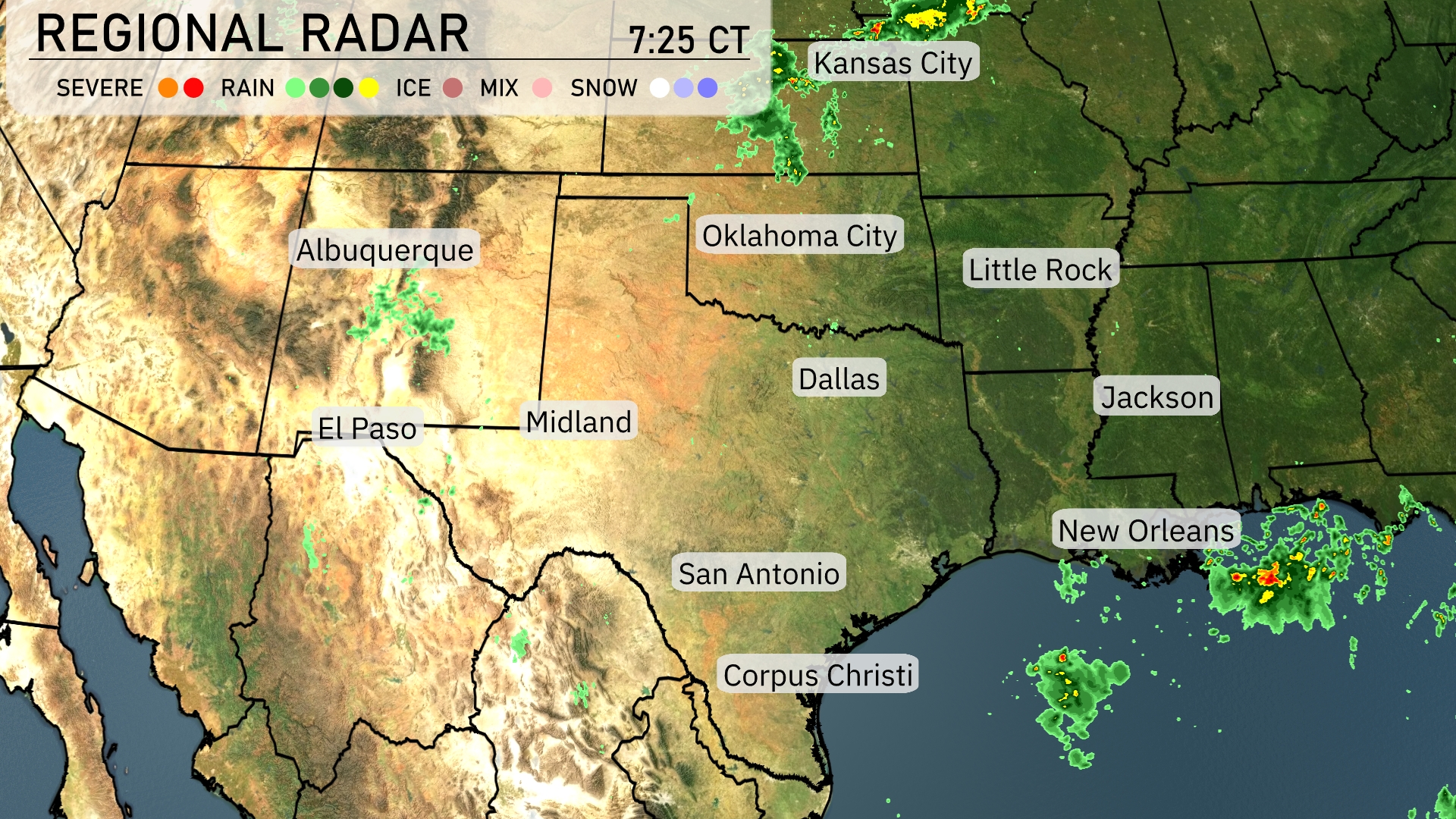
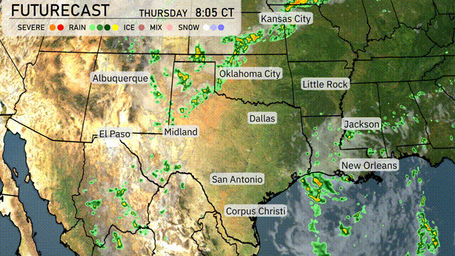
On the Regional Radar, the Southern Plains are experiencing a generally dry stretch, with minimal cloud cover across Texas and Oklahoma. Isolated showers are popping up near El Paso and moving slightly east towards Midland. Meanwhile, the area around New Orleans is dealing with rain activity, pushing east along the Gulf Coast. Kansas City can expect a break from wet weather as the skies remain mostly clear.
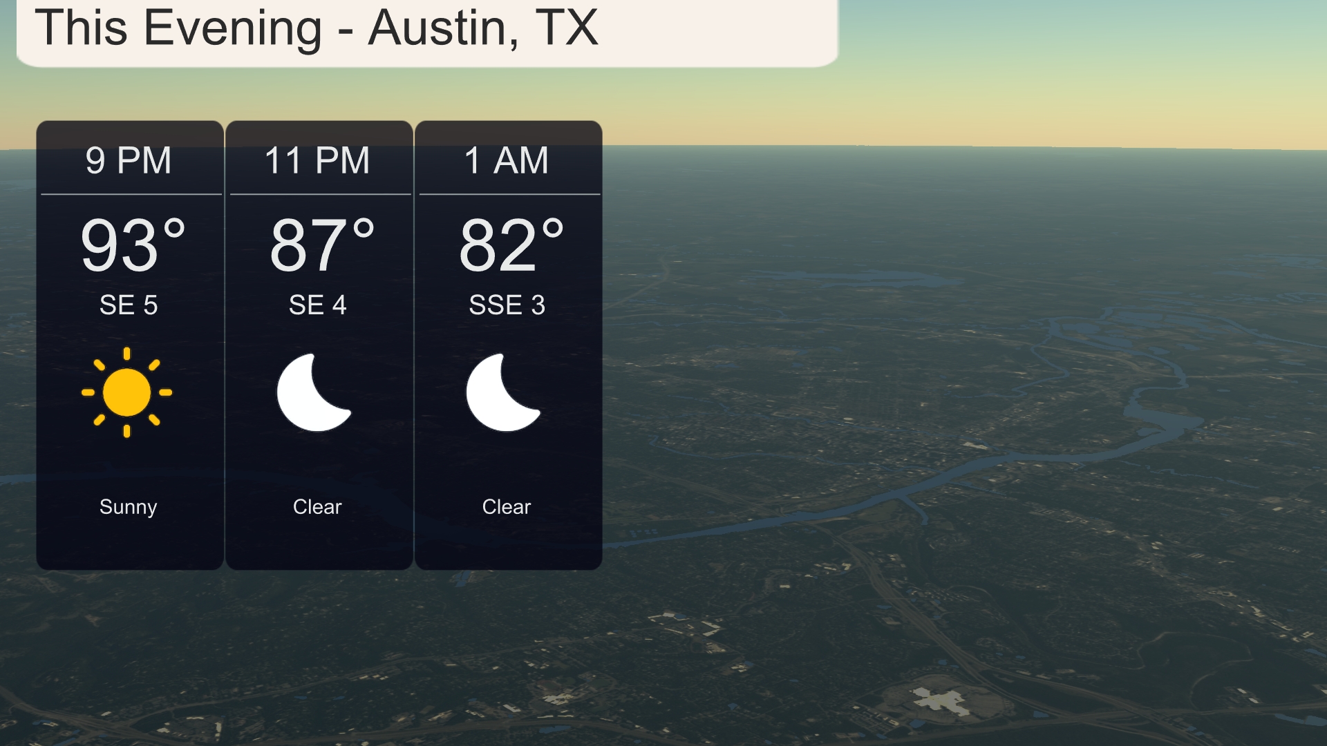
For this evening in Austin, temperatures will gradually decrease from 93 degrees at 9 PM to 82 degrees by 1 AM. Expect clear skies throughout the evening with a gentle southeast wind of 5 miles per hour slowing to 3 miles per hour late night. Perfect conditions for stargazing or a late-night walk, with a steady and comfortable atmosphere.
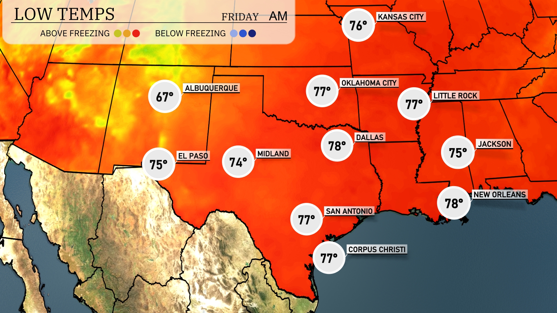
Tonight, temperatures across the Southern Plains will remain relatively mild. Dallas is expected to cool down to 78 degrees, while San Antonio sees a low of 77. El Paso will drop to 75 degrees. Overall, expect a comfortable night with no significant temperature drops in this region.
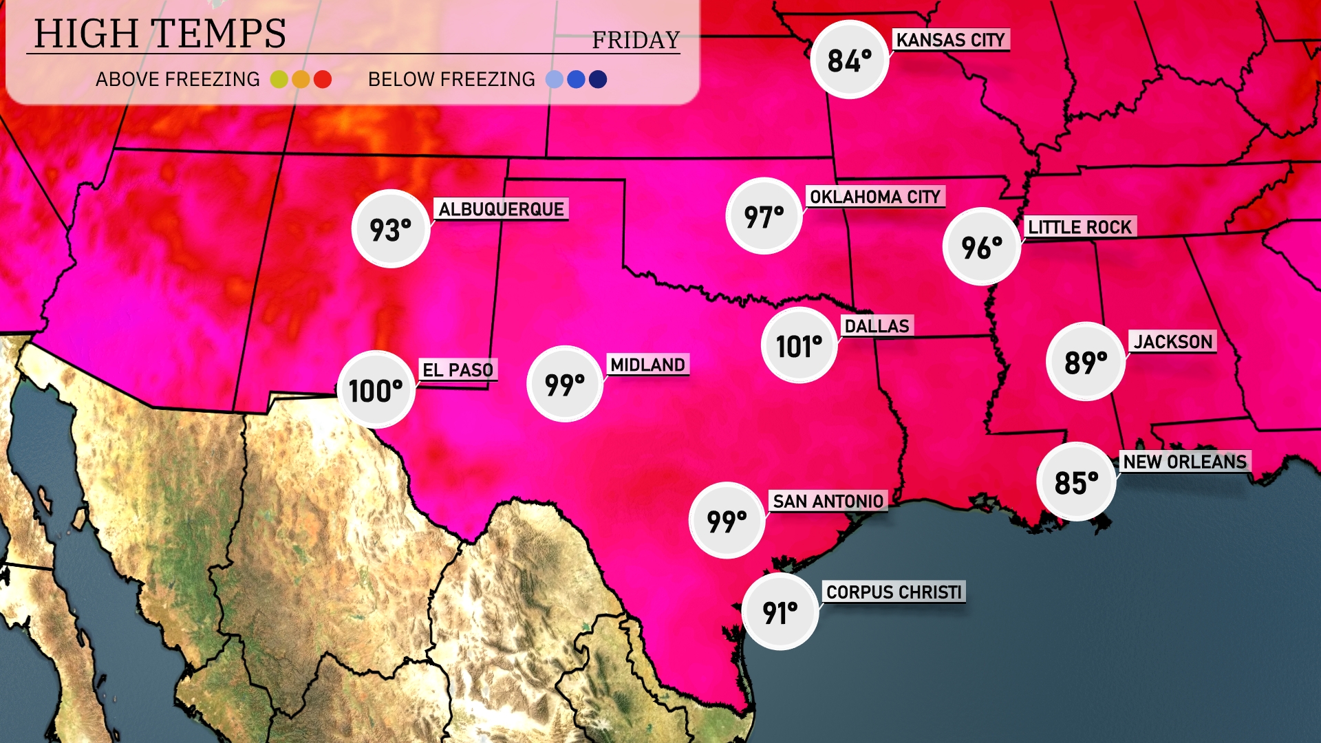
Tomorrow, Dallas will reach a sizzling 101 degrees, while Midland is also in for a hot day at 99 degrees. El Paso is expected to hit 100 degrees, marking above-average temperatures across the Southern Plains. In San Antonio, look for a high of 99 degrees, keeping the heat wave consistent throughout the region. Meanwhile, New Orleans will see a slightly cooler 85 degrees, but Jackson will warm up to 89 degrees.
Prepare for a wet start in the Southern Plains tomorrow as scattered showers and thunderstorms develop from Dallas to Corpus Christi. There’s potential for severe weather, especially around Oklahoma City, with damaging winds and heavy rainfall likely. A cold front pushing in will amplify storm intensity through the afternoon, bringing a risk of flash flooding in low-lying areas. By late evening, expect conditions to largely clear as the system moves east. For those in Midland and El Paso, keep an eye out for rapidly changing weather but expect drier conditions as the system shifts eastward.
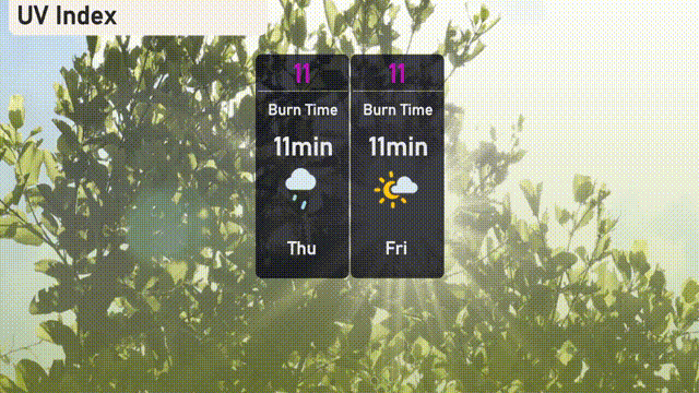
The UV index in Austin is extremely high at 11 for both today and tomorrow. There’s a very short burn time of just 11 minutes in direct sunlight, so wearing sunscreen, hats, and sunglasses is essential. Keep an eye on any clouds or storms that might offer brief respites from the sun’s intensity.
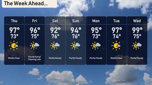
For the 7-day outlook in Austin:
Thursday: Mostly clear skies with a high of 97 degrees and a low around 73 degrees.
Friday: Clouds build early, but clear out later with temperatures peaking at 96 degrees and dipping to 75 degrees at night.
Saturday: Partly cloudy conditions expected with a high of 92 degrees and a low of 76 degrees.
Sunday: Another partly cloudy day, the high temperature reaching 94 degrees with a nighttime low of 76.
Monday: Skies clear up a bit with mostly sunny conditions, a high of 95 degrees, and lows around 73 degrees.
Tuesday: Mostly clear weather, temperatures soaring to a high of 97 degrees and a low of 74 degrees.
Wednesday: Partly cloudy, with the hottest day of the week reaching 99 degrees and a low of 75 degrees.
Stay safe and keep cool!