Austin to Southern Plains: A Week of Weather Wonders
By
Amy Freeze
Explore a detailed week of weather from Austin's partly cloudy skies to the Southern Plains' cooler nights and thunderstorms. Meteorologist Amy Freeze provides insightful forecasts and safety tips.
Meteorologist Amy Freeze delivers the latest on Austin’s weather and the evolving conditions across the Southern Plains. Expect shifts from warm sunny days to cool, brisk nights as Amy guides you through the upcoming week.
Austin ramps up for a mix of partly cloudy days and clear skies with temperatures peaking at 86 degrees. Meanwhile, Southern Plains can brace for everything from severe thunderstorms to mild afternoons. Join Meteorologist Amy Freeze as she offers detailed forecasts tailored to residents, from Austin’s pleasant evenings to potential storm threats around Oklahoma City. Stay safe and weather-smart with our comprehensive updates.
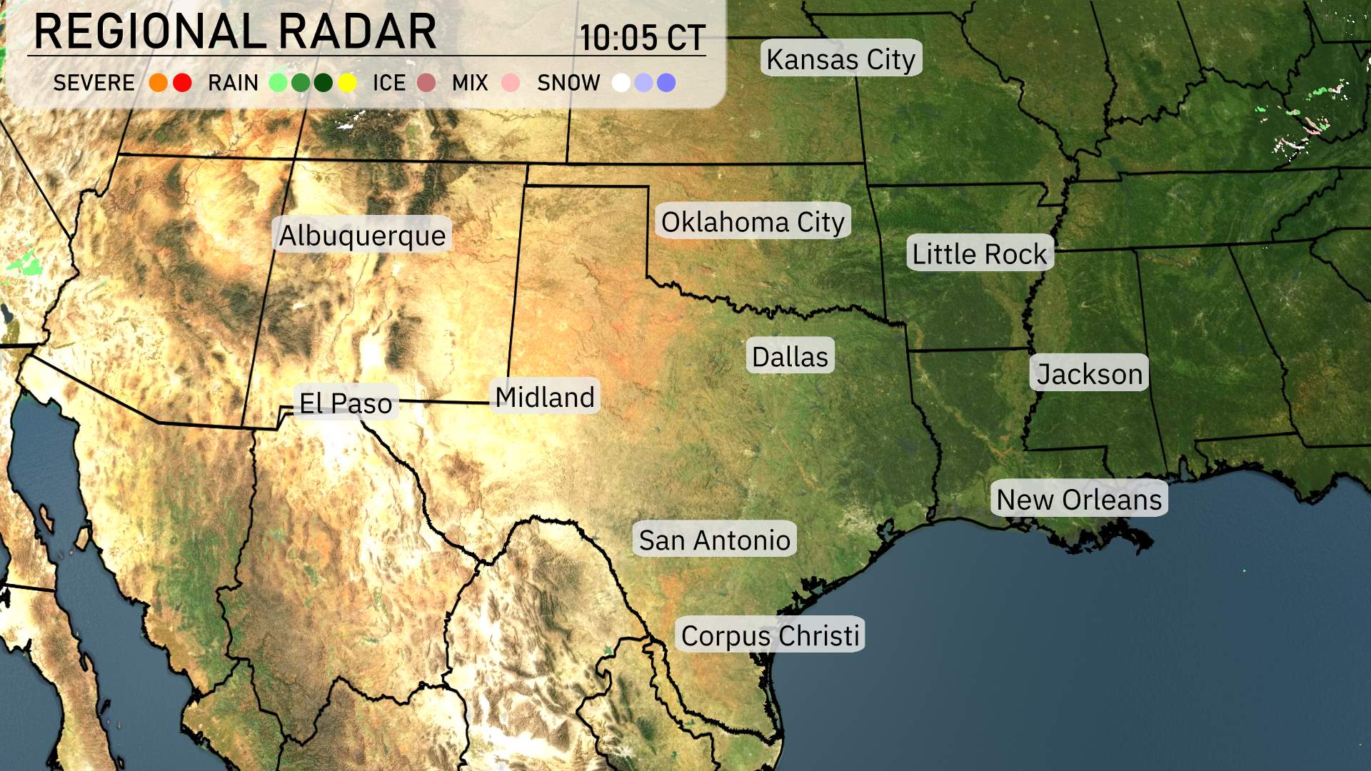
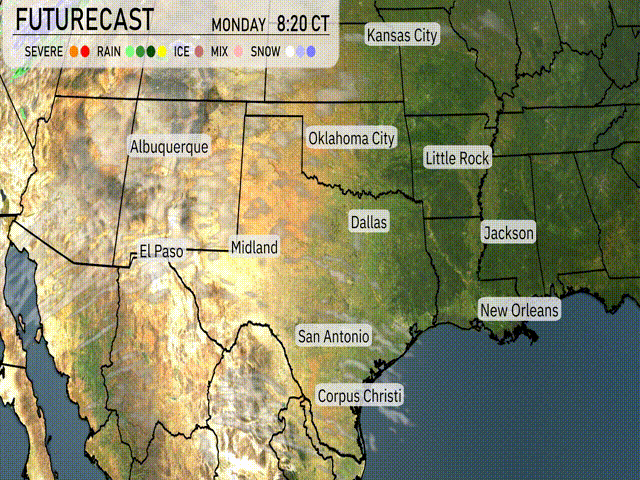
Across the Southern Plains, the regional radar shows clear conditions in much of the region, with exceptions noted for some specific areas. In the Oklahoma Panhandle, some rain showers are passing through, indicating movement from west to east, suggesting wet weather approaching for locations such as Oklahoma City. Meanwhile, snow is falling in the higher elevations along the southern Colorado border, combined with potential gusty winds in these mountainous areas. Farther to the south around the lower Mississippi Delta, rain is beginning to develop, hinting that wet weather is on the increase for places like Jackson, and this system may continue to build towards areas like Little Rock.
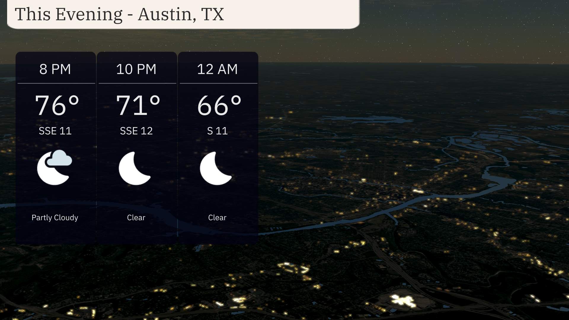
For this evening in Austin, expect temperatures to start at 76 degrees at 8 PM, dropping to 66 degrees by midnight. Wind from the south-southeast begins at 11 miles per hour and decreases to 11 miles per hour by the late evening. Cloud cover will clear as the night progresses, providing a calm and pleasant evening.
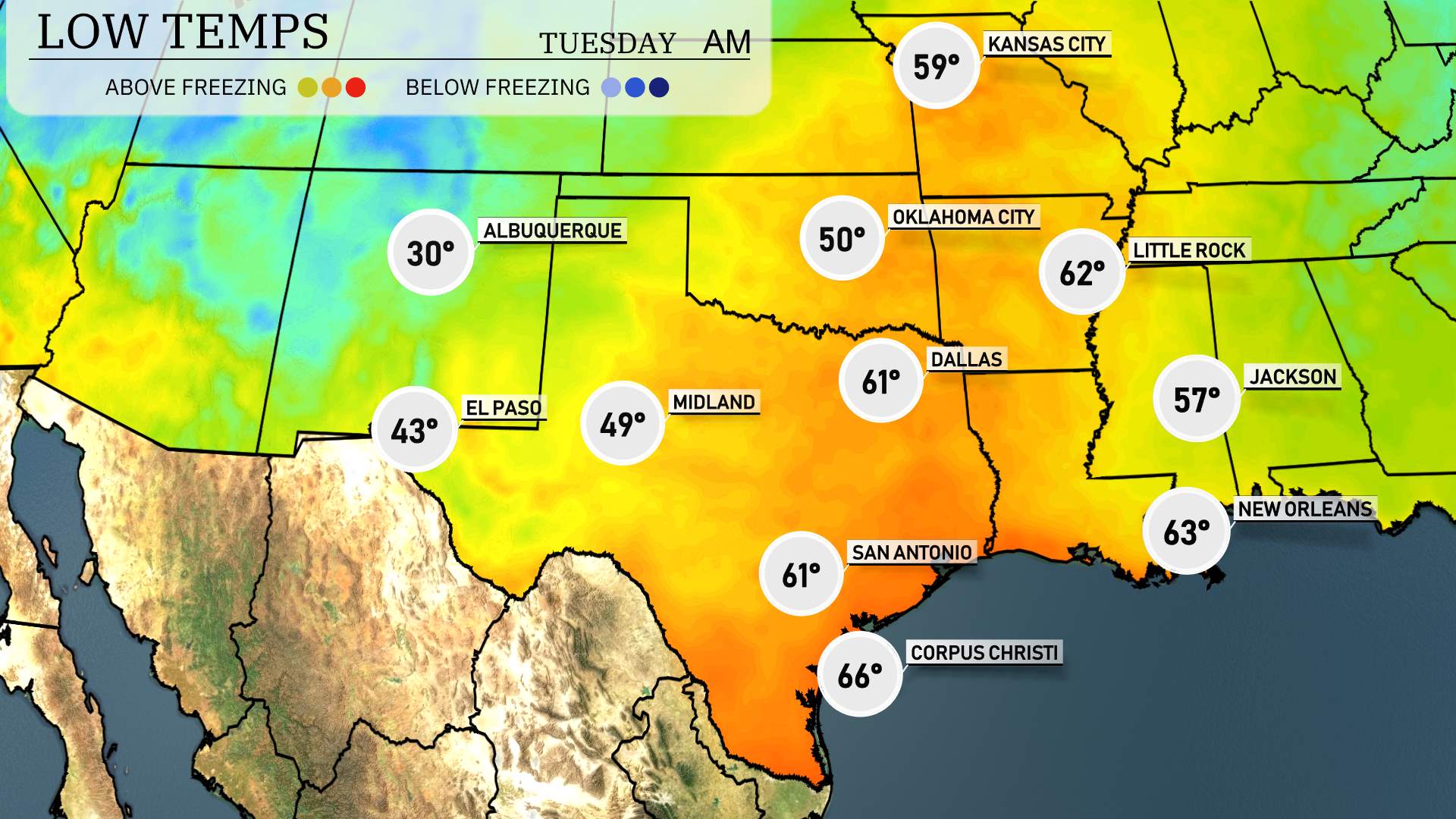
In the Southern Plains, temperatures are dipping significantly as a cold front moves through. Expect Amarillo to see a chilly 30 degrees, while Lubbock will drop to 33. In Oklahoma City, the forecast is for 50 degrees, with Little Rock cooling down to 62. Dallas is slightly warmer at 61 degrees, and San Antonio will also be at 61. Meanwhile, the coastal regions like Corpus Christi will remain milder, only reaching 66 degrees. Overall, prepare for a brisk and cool night across the region.
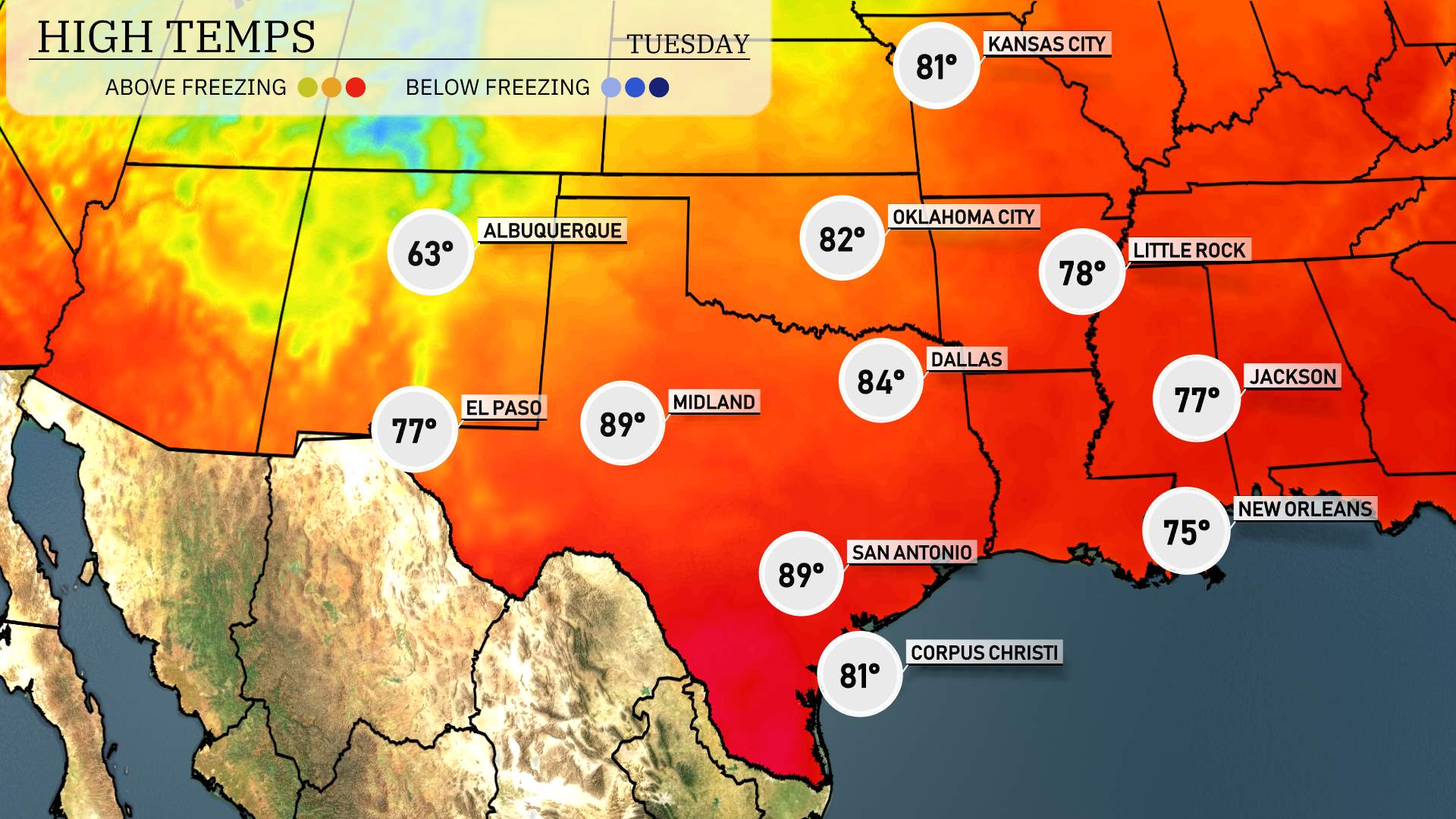
High temperatures for tomorrow in the Southern Plains show above-average readings across much of the region. In El Paso, look for a high of 77 degrees, while Midland is set to soar to 89 degrees, a notably warm day. San Antonio also expects a high of 89 degrees, reflecting the warm trend. Corpus Christi will see a comfortable high of 81 degrees. Meanwhile, Dallas will be slightly cooler at 84 degrees. Oklahoma City registers at 82 degrees, and Little Rock rounds out the region with a high of 78 degrees. Overall, these temperatures indicate a warm pattern continuing into the week.
“The Southern Plains will experience dynamic weather conditions over the next 24 to 48 hours. Expect widespread rain showers from San Antonio to Corpus Christi, offering much-needed relief to the region. Oklahoma City and surrounding areas may see a risk of severe thunderstorms, especially with a cold front pushing through. Keep an eye out for potential weather warnings. Areas near Dallas should prepare for gusty winds and localized heavy rain. Temperatures will fluctuate, cooling significantly after frontal passage by Wednesday evening.”
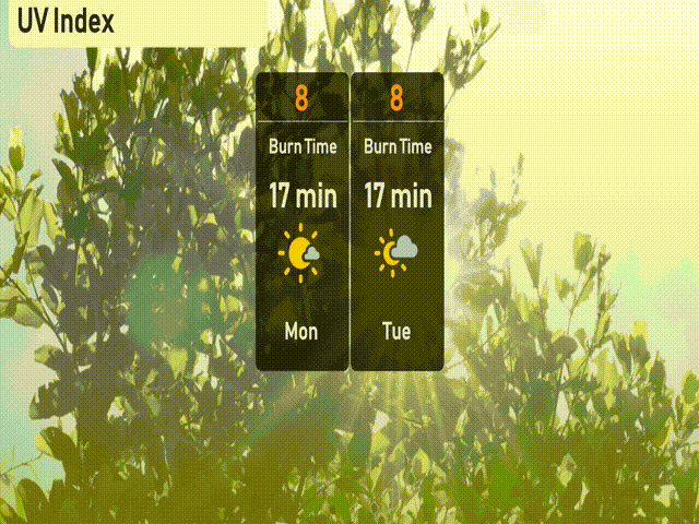
The UV index in Austin will be very high at 8 on Monday and Tuesday, with burn times as short as 17 minutes. Sun protection is crucial—apply sunscreen, wear protective clothing, and seek shade during peak sun hours!
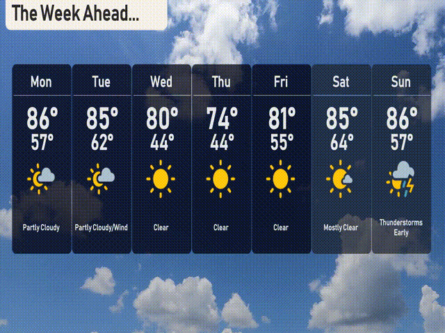
For the 7-day forecast in Austin:
Monday: Partly cloudy with a high of 86 degrees and a low around 57.
Tuesday: Expect partly cloudy skies and some wind with a high of 85 degrees and a low of 62.
Wednesday: Sunny conditions as the high reaches 80 degrees, cooling to 44 at night.
Thursday: Clear skies, with temperatures climbing to 74 degrees, and lows dipping to 44.
Friday: Another clear day with a comfortable high of 81 degrees and a low of 55.
Saturday: Mostly clear, warming up to a high of 85 degrees and a low of 64.
Sunday: Thunderstorms expected early in the day with a high of 86 degrees, dropping to 57 overnight.
Stay safe!