Sunny Days and Stormy Nights: Austin’s Spring Weather Unpacked
By
Amy Freeze
Meteorologist Amy Freeze provides an insightful look into the varied weather patterns sweeping over Austin and the Southern Plains, from clear skies to potential storms. Get your detailed weather forecast for the week right here.
Meteorologist Amy Freeze details Austin’s weather this spring, from sunny highs of 87°F to stormy evenings. Find out how this affects your weekly plans with our concise summary.
Welcome to a comprehensive overview of Austin’s spring weather presented by Amy Freeze. As we step into spring, Austin enjoys clear skies and sunshine. However, the scene across the Southern Plains is mixed with snow and rain in other parts. In this post, Amy Freeze will guide you through daily temperatures, severe weather alerts, and UV index warnings. With a close eye on the futurecast, she also prepares you for potential storms. Whether planning outdoor activities or just curious about the weather, her insights will keep you informed and ready.
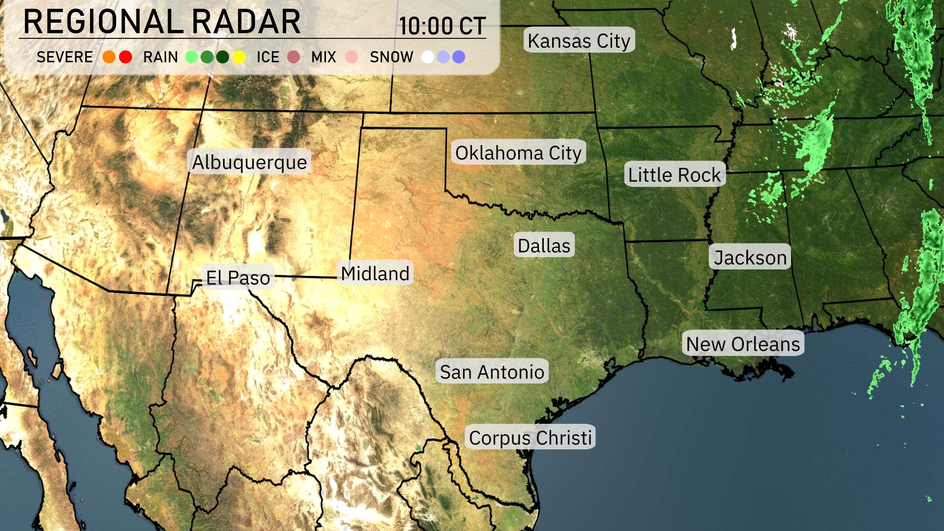
Across the Southern Plains, the regional radar indicates relatively calm conditions, with a few exceptions. Snow is falling along the southern Colorado border, adding some wintry scenes to the higher elevations. In the Oklahoma Panhandle, light rain showers are making their way through, providing some moisture to the area. Rain is intensifying in the lower Mississippi Delta as a storm system takes shape, bringing showers to areas around New Orleans and Jackson. Clear skies prevail farther west, from Albuquerque to Midland, allowing for a dry and pleasant day.
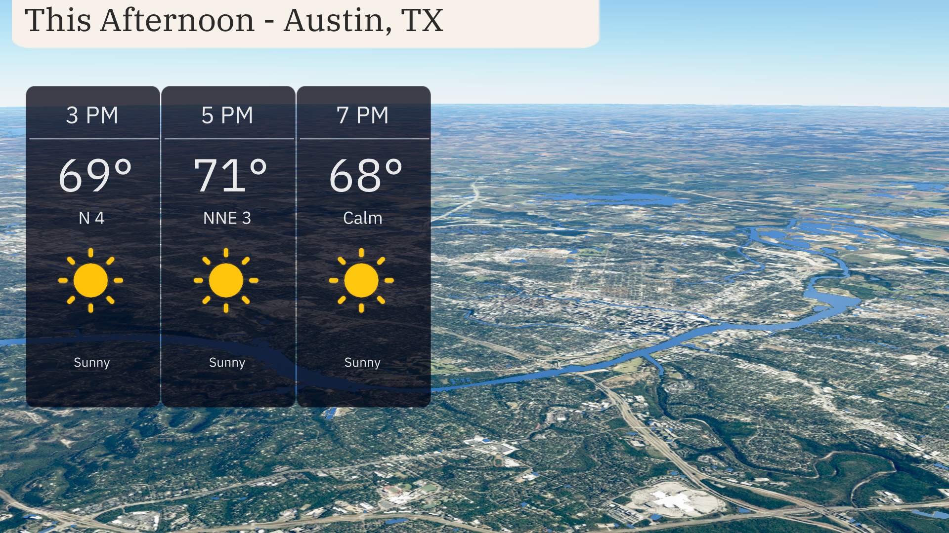
Temperatures in Austin this afternoon will reach 71 degrees by 5 PM, with a gentle north-northeast breeze at 3 miles per hour. Starting off at 69 degrees around 3 PM, the day features pristine conditions with bright sunshine. As we progress into the early evening, temperatures ease back to 68 degrees by 7 PM, accompanied by calm winds. It’s a beautiful day for outdoor activities, so enjoy the pleasant weather!
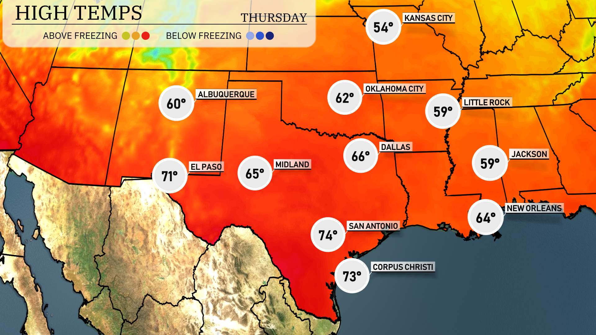
Let’s take a look at today’s high temperatures across the Southern Plains.
In El Paso, we’re seeing a warm day with a high of 71 degrees. Midland will be slightly cooler, reaching 65. Moving over to Dallas, it’s a bit warmer at 66, while San Antonio feels pleasantly mild, topping out at 74 degrees. Down along the coast, Corpus Christi enjoys a high of 73 degrees.
Notably, it’s a cooler day for areas farther to the north, with Oklahoma City hitting just 62 and Little Rock at 59. Overall, temperatures are quite varied, presenting a mix of warmth and cooler spots across the region.
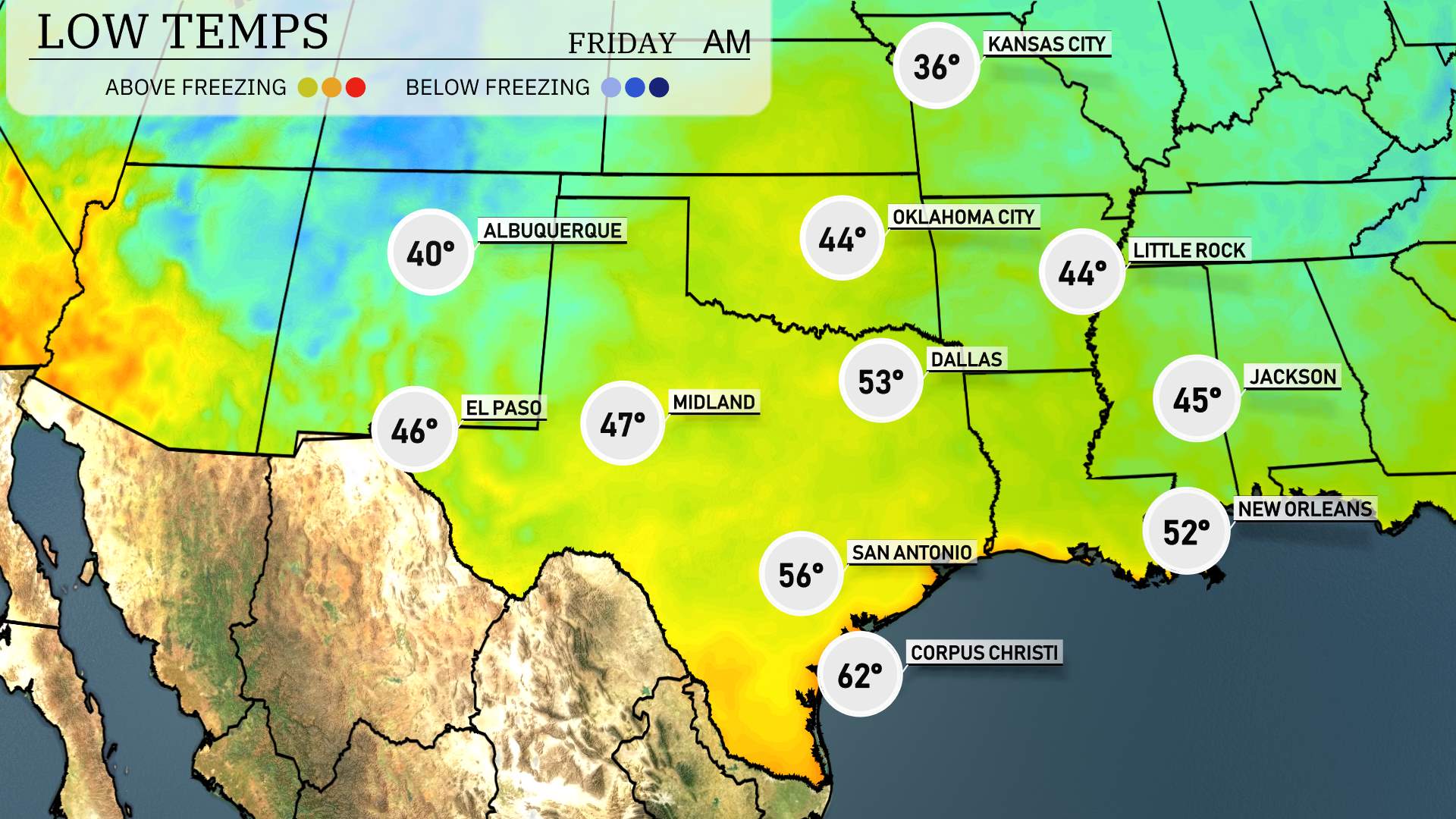
In the Southern Plains, prepare for a chilly night ahead. Key cities will see significant drops in temperature. Oklahoma City will drop to 44 degrees, while Dallas is expected to cool down to 53. In Texas, El Paso will reach a low of 46 degrees, and Midland will see 47. San Antonio will be slightly milder at 56, with Corpus Christi ending the night at 62. Expect Little Rock to also feel the chill with a low of 44. It’s a cold air pattern settling in tonight across the region.
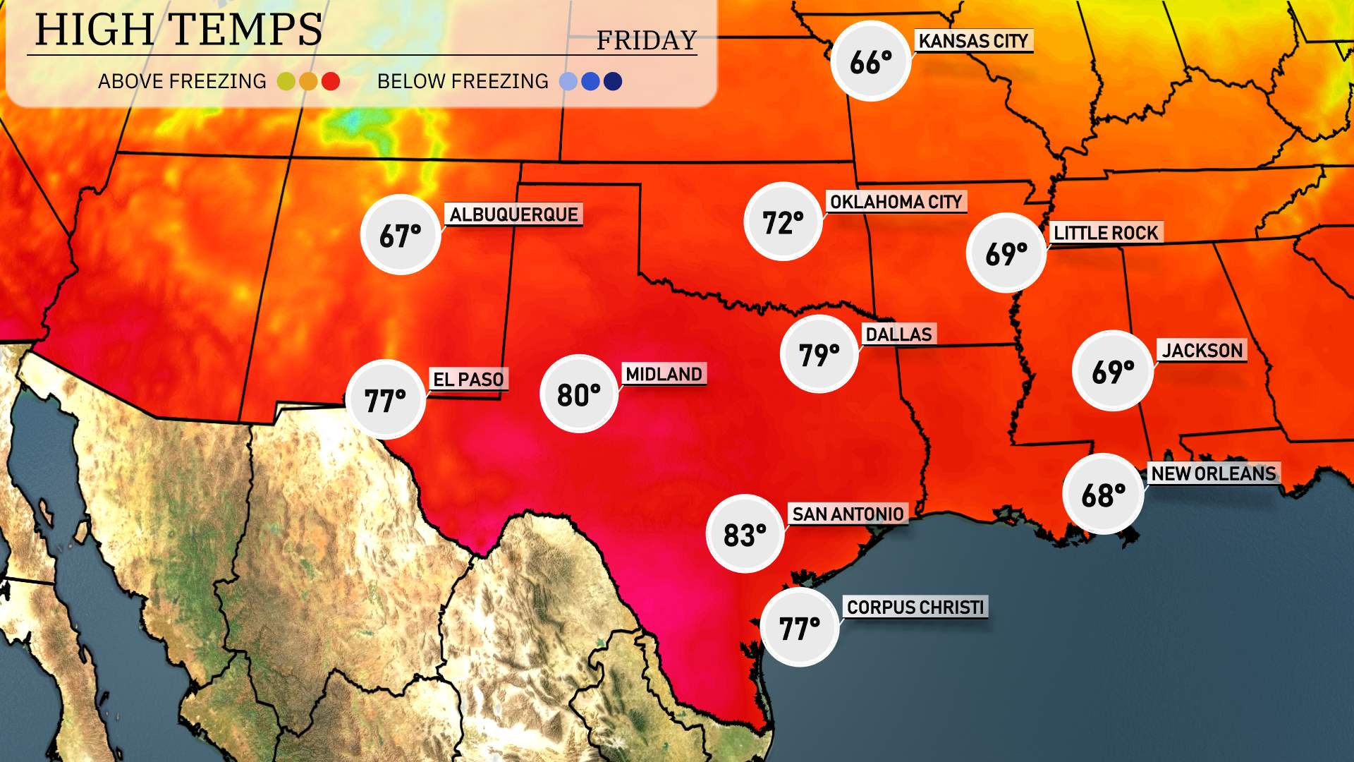
High temperatures for the Southern Plains region tomorrow are looking robust and above average due to a warm front moving through. In El Paso, expect a high of 77 degrees, while Midland could reach a warm 80 degrees. San Antonio is set to have a balmy high of 83 degrees, indicating a pleasant day. In Corpus Christi, temperatures are forecasted to hit 77 degrees, providing nice conditions along the coast. Dallas will see a high of 79 degrees, maintaining the warmth across the area. Oklahoma City is expected to get to 72 degrees, showcasing overall seasonal warmth. This trend signals a continued warming pattern as we transition into spring.
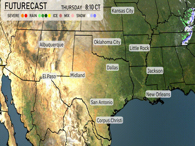
“On the futurecast for the Southern Plains, anticipate a busy weather day ahead. Rain showers are set to impact regions stretching from Dallas to Corpus Christi, bringing beneficial moisture to the area. Farther north, Oklahoma City may experience more intense storms. With an unstable air mass converging with an approaching cold front, be prepared for possible severe weather alerts lasting through Thursday evening. Stay vigilant for any changes and weather advisories in the upcoming 24 to 48 hours.”
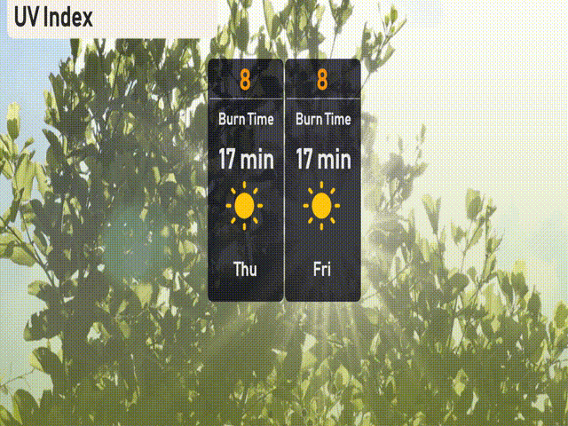
The UV index in Austin registers a level of 8 for both Thursday and Friday, indicating a very high risk of harm from unprotected sun exposure. With a burn time of just 17 minutes, it’s essential to apply sunscreen generously and consider wearing protective clothing if you’re planning to be outdoors.