Austin’s Cloudy Forecast: Gearing Up for a Weather-Wise Week
By
Amy Freeze
Explore today's weather conditions across Austin with a detailed look at the cloudy skies, impending storm systems, and the essential sun safety tips needed for a UV index of 11.
This week in Austin, expect mostly cloudy skies with temperatures hovering around the high 80s and low 90s. A storm front is making its way towards us, so get ready for some wet weather!
As we delve into this week’s forecast for Austin and the Southern Plains, you’ll notice a consistent pattern of mostly cloudy skies with temperatures peaking in the mid-90s. However, it’s not just about temperature; a significant storm front is approaching from the northeast, bringing potential severe weather into our area. We’ll cover what this means for your daily plans and how to protect yourself from the very high UV levels we’re experiencing. Follow along for daily updates and sun safety tips as we navigate Austin’s dynamic weather together!
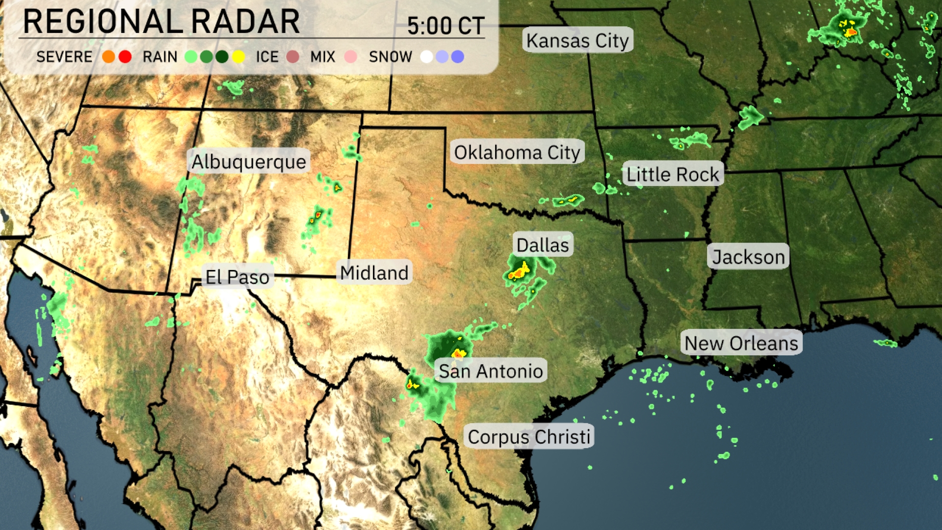
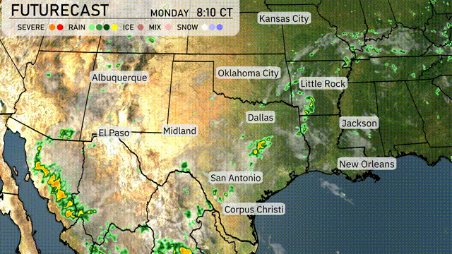
A line of storms is advancing northeast of Dallas, TX, bringing precipitation to the area with the potential for more severe weather as it moves. Showers are spotted in central Texas near San Antonio, slowly migrating toward Austin. Further west, El Paso is seeing some light rain showers, while most of the surrounding areas remain clear. Scattered showers are appearing near Albuquerque, with cloud cover extending toward central New Mexico.
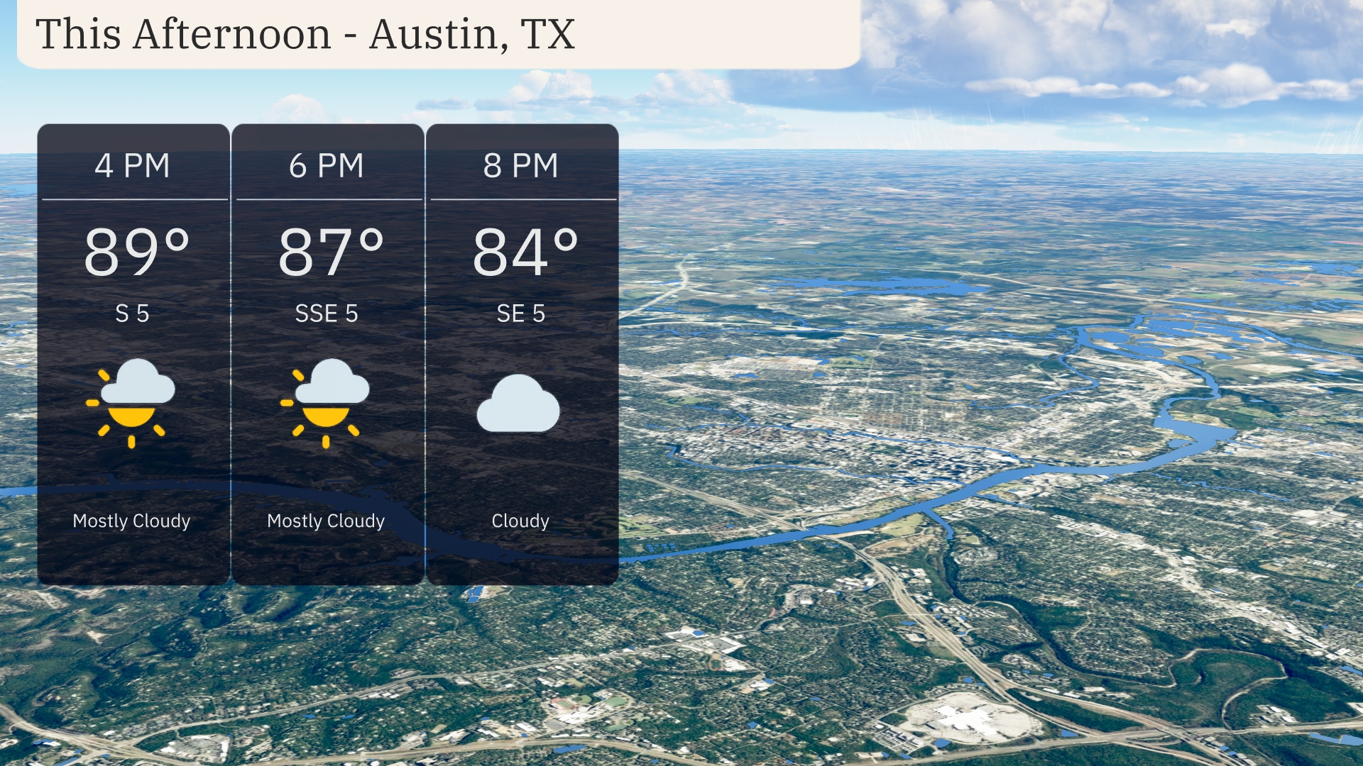
Afternoon temperatures in Austin are warming up to 89 degrees, accompanied by a gentle south wind at 5 miles per hour. Clouds will dominate, with mostly cloudy skies keeping the sun at bay. The temperature gradually eases to 87 degrees by 6 PM as winds shift slightly from the south-southeast at 5 miles per hour. By 8 PM, expect the temperature to drop to a cooler 84 degrees with cloudy skies continuing.
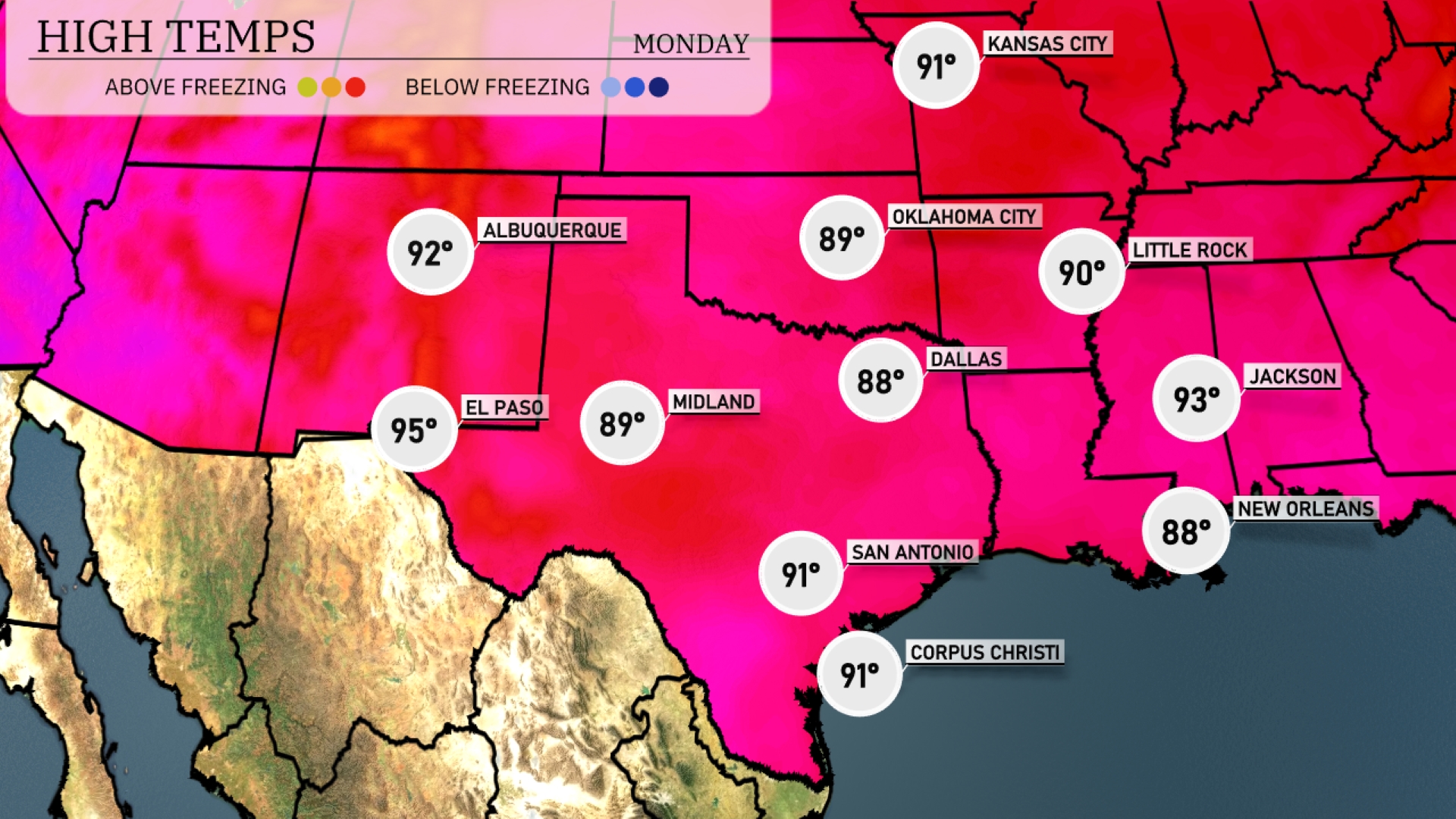
Today’s high temperatures in the Southern Plains are heating up significantly. Expect El Paso to reach a sizzling 95 degrees, while Midland will also enjoy a warm day at 89 degrees. San Antonio will see a high of 91 degrees, indicating a comfortable afternoon. In contrast, Dallas remains cooler at 88 degrees, while nearby in Jackson, the thermometer climbs to 93 degrees. Meanwhile, Little Rock rounds out the region with a decent high of 90 degrees, showcasing some temperature variation across the area.
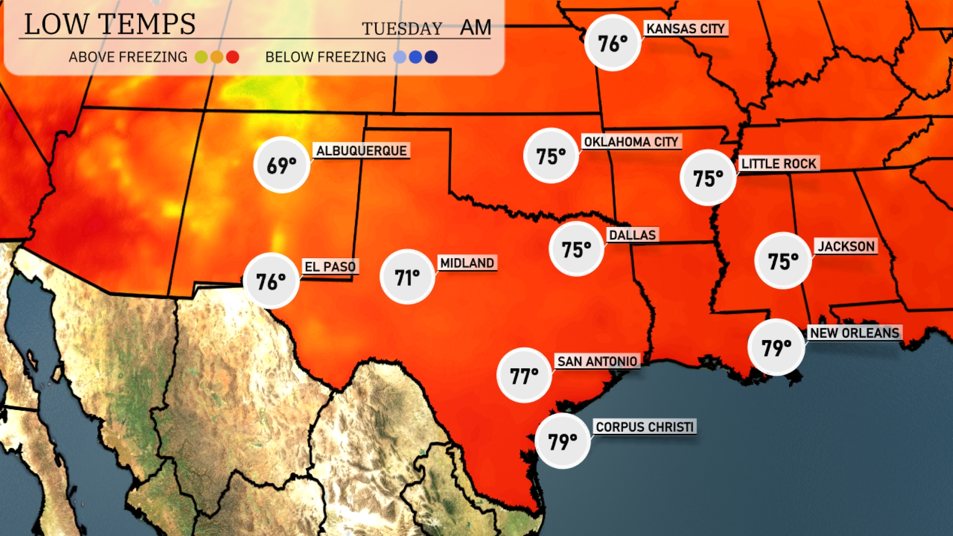
Tonight, Oklahoma City will see a low of 75 degrees, while Dallas is expected to drop to 75 as well. In Arkansas, Little Rock will have a low of 76 degrees, and further south in Texas, San Antonio is projected to stay warmer at 77 degrees. New Orleans rounds out the region with a low of 79 degrees, maintaining the milder temperatures across the Southern Plains.
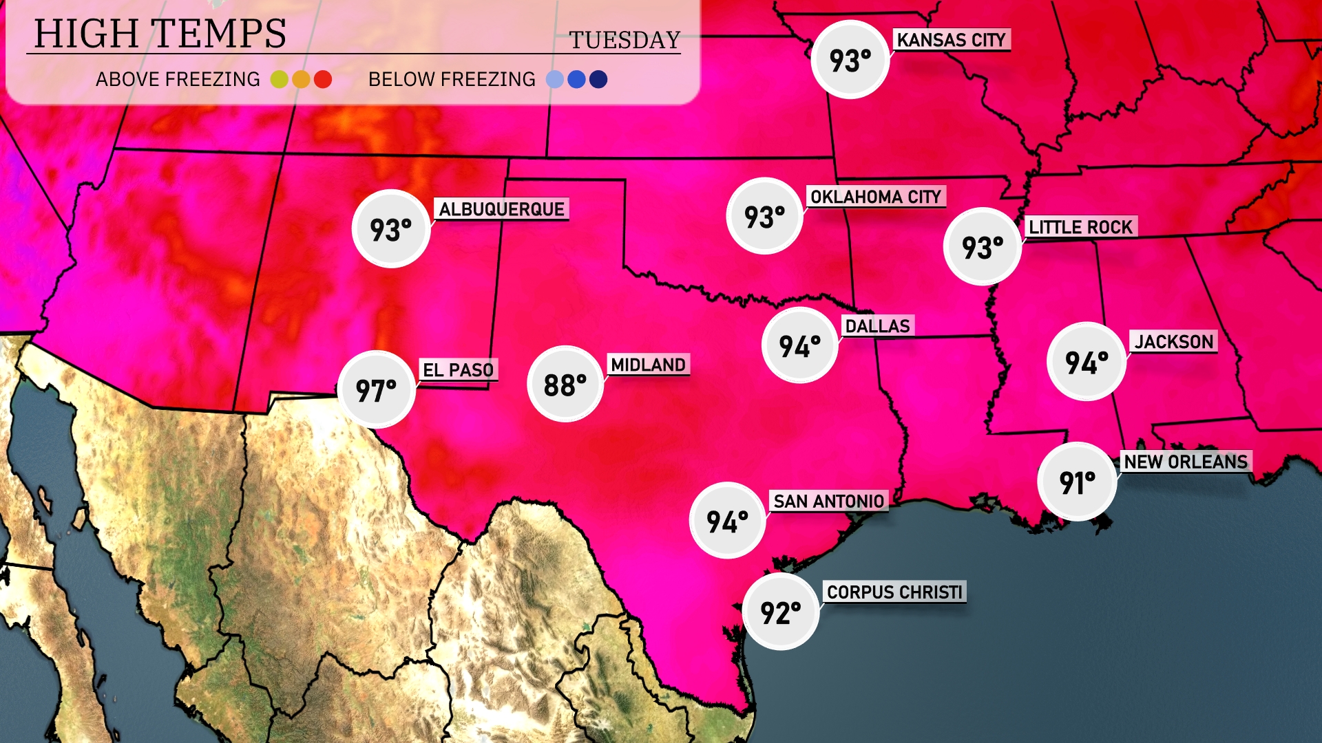
Tomorrow in the Southern Plains, El Paso will see a high of 97 degrees, while Midland climbs to 88 degrees. San Antonio is expected to reach 94 degrees, maintaining above-average temperatures for this time of year. In Dallas, the high will be slightly cooler at 94 degrees. New Orleans will also be warm, with an expected high of 91 degrees, indicating a broader trend of elevated temperatures across the region.
A cold front will approach the Southern Plains tomorrow, sparking showers and thunderstorms from Dallas southward to Corpus Christi, bringing essential rainfall to the region. Oklahoma City may experience severe storms with potential strong winds and hail, so stay weather aware. By late evening, the frontal system is expected to advance toward the eastern part of the Southern Plains, increasing the risk of severe weather in southeast areas. On the upside, the cooler air following the front will drop temperatures by several degrees. Prepare for possible flood advisories in areas with heavy rainfall accumulation.
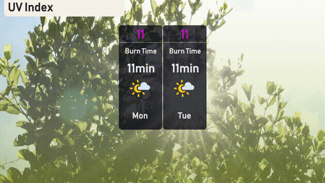
In Austin, the UV index is at a very high level of 11 both today and tomorrow, with potential burn times as quick as 11 minutes. Be sure to take precautions if you’re planning to enjoy the outdoors; apply sunscreen liberally, wear a wide-brimmed hat, and seek shade during peak sun hours! Stay sun-safe!