Austin’s Sunny Start to a Stormy Week: Weather Forecast and Tips
By
Amy Freeze
Explore the dynamic weather of Austin and the Southern Plains, from scorching sun to brewing storms. Get your full 7-day forecast and safety tips for high UV days!
Expect a sunny morning tomorrow in Austin; however, the skies mask an active week ahead with a forecast of heat and storms. Don’t miss the weather trends and advice on UV protection!
The Southern Plains, including Austin, starts with clear skies but the forecast quickly changes with developing storms and high temperatures across the region. Austin faces an extreme UV index, demanding precautions outdoors. With a thorough 7-day weather outlook, understand what these conditions mean for your week and learn tips on handling the sweltering heat and severe weather threats effectively.
Conditions across the Southern Plains are mostly clear, with some activity highlighted on the radar. Showers are developing along the Texas coast near Corpus Christi and moving northward. Light rain is detected in areas south of San Antonio. The rest of the region, including cities like Dallas and Oklahoma City, remains tranquil with no significant weather systems in sight.
Temperatures in Austin tomorrow morning will begin at 76 degrees at 8 AM, with mostly cloudy skies. By 10 AM, expect the temperature to rise to 80 degrees, accompanied by partly cloudy conditions and a south wind at 5 miles per hour. At noon, the temperature climbs to 86 degrees, with plenty of sunshine and a gentle southeast breeze at 6 miles per hour.
Tomorrow, El Paso is set to reach a high of 93 degrees, while Midland will be slightly cooler at 91. San Antonio and Little Rock will both spike to 95 degrees, indicating unseasonably warm temperatures for the region. Dallas will see a high of 95, showing a trend of above-average readings across the Southern Plains. In contrast, New Orleans is anticipated to have a more moderate high of 90 degrees, offering a brief respite from the heat.
Looking ahead on the futurecast for the Southern Plains, brace for an active weather scenario. A line of storms is projected to initiate from Dallas to Corpus Christi, delivering beneficial rain. Oklahoma City may encounter more intense storm activity, potentially severe. An unstable air mass combined with an incoming cold front heightens the risk for severe weather across the region, spanning from southeast Oklahoma through North Texas into Wednesday night.
Austin is experiencing an extreme UV index of 11 today and tomorrow, implying rapid sunburn in just 11 minutes without protection. Be vigilant while outdoors, using sunscreen and seeking shade, especially during peak sunlight hours.
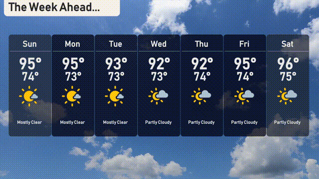
For the 7-day outlook in Austin:
Sunday: Mostly clear skies with a high of 95 degrees and a low of 74 degrees.
Monday: Expect another mostly clear day, hitting 95 degrees during the afternoon and cooling to 73 at night.
Tuesday: Continued mostly clear conditions with a high of 93 degrees and a low of 73 degrees.
Wednesday: Partly cloudy skies with a daytime high of 92 degrees and a low around 73 degrees.
Thursday: Similar conditions persist with partly cloudy skies and temperatures peaking at 92 degrees, cooling to 74 degrees overnight.
Friday: Partly cloudy conditions continue with a high of 95 degrees and a low of 74 degrees.
Saturday: The week wraps up with partly cloudy skies and the temperature reaching 96 degrees, dropping to 75 degrees at night.