Explore the dynamic weather patterns from sizzling heats to stormy horizons in Austin and the Southern Plains. Get your detailed forecast here!
Austin braces for a hot and stormy week ahead! With temperatures reaching the high 90s and potential thunderstorms, how will this affect your week? Read more!
This week in Austin spells dramatic differences from clear, sunny skies to the anticipation of stormy weather. Expect intense heat with temperatures nearing triple digits, and don’t be caught off-guard by the severe thunderstorm possibilities. Check out our in-depth analysis of the Southern Plains weather as we track temperature spikes, forecast potential severe weather, and guide on staying safe during extreme heat. Remember, with a UV index of 11, protection from the sun is crucial! For more detailed daily forecasts, visit our blog.
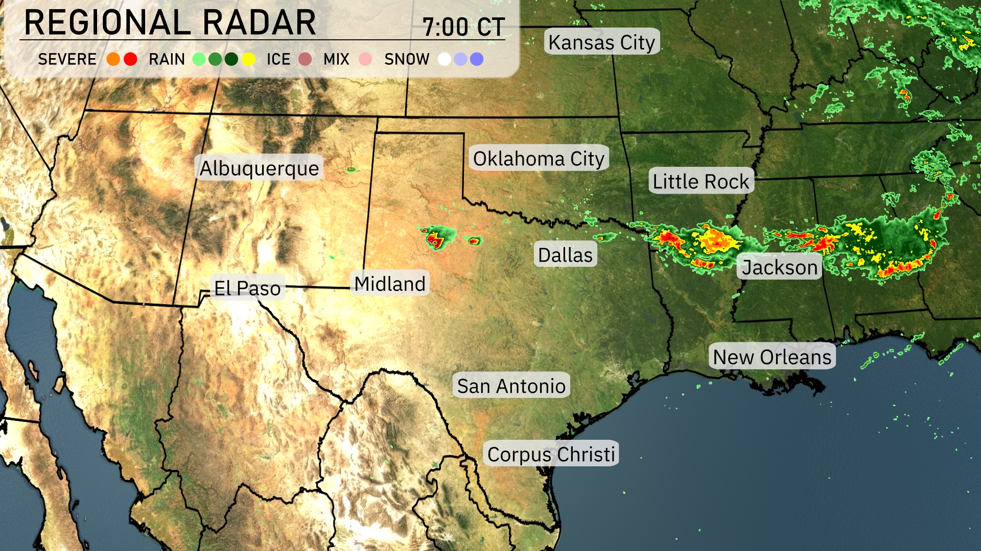
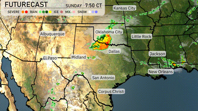
The Southern Plains radar indicates active weather patterns. A strong line of thunderstorms is moving across northern Louisiana, impacting areas like Jackson with severe conditions. Meanwhile, a smaller storm cell near Amarillo in the Texas Panhandle suggests localized rain. The rest of the Southern Plains, including Dallas and Oklahoma City, remains under clear skies.
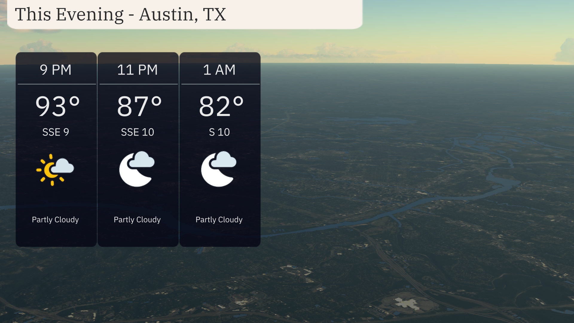
For this evening in Austin, temperatures will gradually dip from 93 degrees at 9 PM to 82 degrees by 1 AM. Expect partly cloudy skies throughout the evening with winds shifting from south-southeast at 9 mph to south at 10 mph.
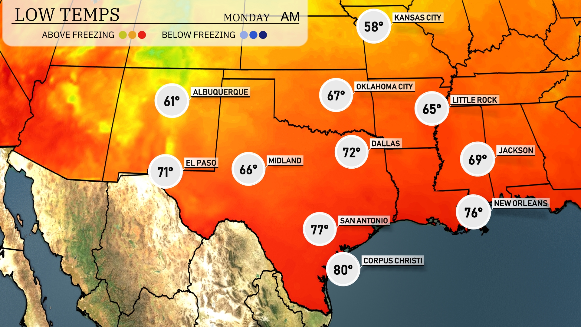
Tonight in the Southern Plains, Dallas will see a low of 72 degrees. Fort Worth is expected to drop to 69, while Little Rock will cool down to 65. Notably, Oklahoma City is forecasted to fall to 67 degrees. San Antonio remains mild with a low of 77, and down in Corpus Christi, expect a warmer night at 80 degrees.
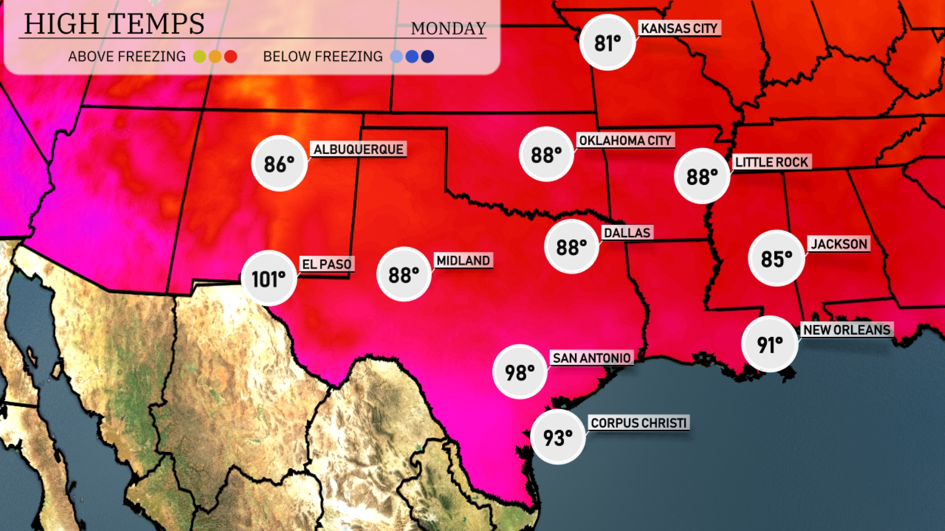
Tomorrow, temperatures soar across the Southern Plains. El Paso will experience a scorching high of 101 degrees, while Midland and Dallas are expected to reach 88 degrees. San Antonio heats up to 98 degrees, and Corpus Christi follows closely at 93 degrees. In the eastern part of the region, New Orleans anticipates a high of 91 degrees, with Jackson not far behind at 85 degrees.
A cold front moving through the Southern Plains tomorrow brings a chance of severe weather, especially around Oklahoma City where thunderstorms could intensify. From Dallas to Corpus Christi, anticipate steady rainfall that brings drought relief. Remain alert for possible severe thunderstorm warnings, particularly in eastern Oklahoma and northern Texas. Beyond the front, drier air sets the stage for cooler, comfortable temperatures across the region by tomorrow night, while any severe weather threat shifts eastward towards Arkansas and Louisiana.
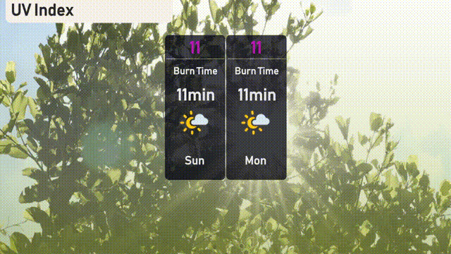
The UV index in Austin will be very high at 11 both Sunday and Monday, indicating intense sun exposure risks. A burn time of just 11 minutes means sunscreen and protective gear are essential for any outdoor activities. Stay sun-safe!
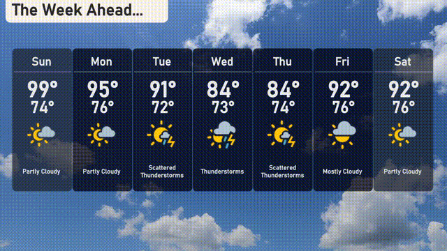
For the 7-day outlook in Austin:
Sunday: Expect it to be partly cloudy with a high of 99 degrees and a low of 74 degrees.
Monday: Partly cloudy conditions continue, with temperatures peaking at 95 degrees and a low of 76 degrees.
Tuesday: Scattered thunderstorms move in, with a high reaching 91 degrees and a low of 72 degrees.
Wednesday: Thunderstorms are expected, with the temperature climbing to 84 degrees and a low of 73 degrees.
Thursday: The stormy pattern persists with scattered thunderstorms, a high of 84 degrees and a low of 74 degrees.
Friday: Conditions dry out a bit with mostly cloudy skies, bringing highs of 92 degrees and lows around 76 degrees.
Saturday: Partly cloudy to wrap up the week with temperatures reaching 92 degrees during the day and dropping to 76 degrees at night.