Austin Heats Up: This Week’s Weather Forecast for the Southern Plains
By
Amy Freeze
Explore the week's dynamic weather in Austin and the surrounding Southern Plains. From heatwaves to storms, know what to expect and how to prepare.
Facing another week of dynamic weather in Austin? From searing heat to potential storms, find out what’s happening weather-wise in the Southern Plains this week.
This week, Austin and the Southern Plains are gearing up for a mix of sizzling temperatures and stormy conditions. With highs topping out at 101 degrees and a severe weather alert in effect, it’s critical to stay prepared. Find detailed forecasts for each day, safety tips amidst the high UV index, and what to do during thunderstorms. For all the updates and weather insights, head over to our blog post: https://amyfreeze.ai/
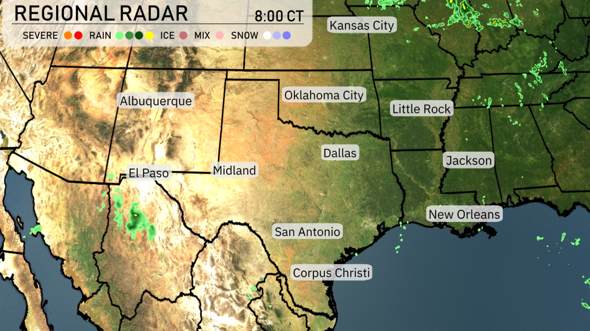
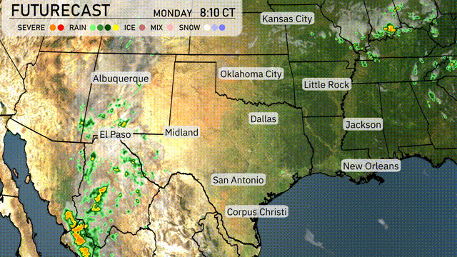
The Southern Plains are seeing scattered showers in eastern New Mexico near El Paso, slowly creeping into the western Texas Panhandle. Dallas and Oklahoma City remain under clear conditions, while isolated storms skirt the edges of the Texas-Louisiana border with some light rain moving towards New Orleans. Little Rock and Jackson are experiencing dry weather as well. The Kansas City area and much of the central and northern regions are clear, providing a calm start to the day.
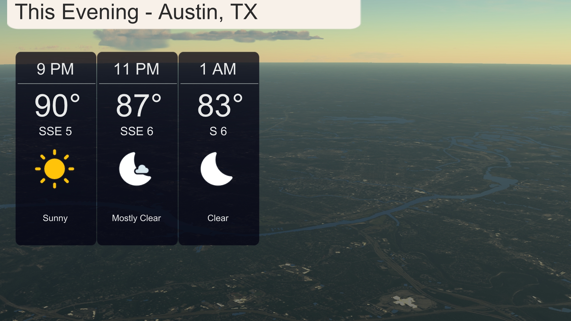
This evening in Austin, temperatures will remain quite warm, starting at 90 degrees at 9 PM. Expect conditions to be mostly clear by 11 PM with temperatures easing to 87 degrees. Winds will be from the south-southeast at 5 to 6 miles per hour. By 1 AM, skies clear further as temperatures drop to 83 degrees with a gentle south breeze.
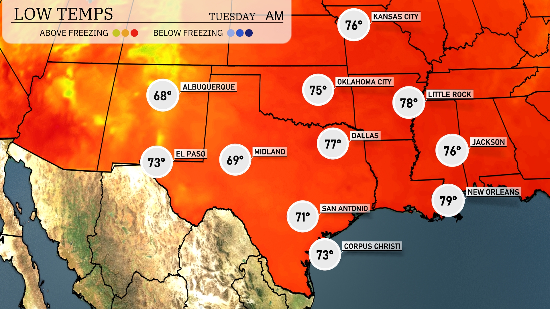
Tonight, temperatures will dip significantly across the Southern Plains. Midland will see a low of 69 degrees, while Dallas drops to 77. San Antonio is expected to cool down to 71 degrees, and Little Rock will reach 78. Expect warmer conditions along the Gulf, with New Orleans holding at 79 degrees overnight.
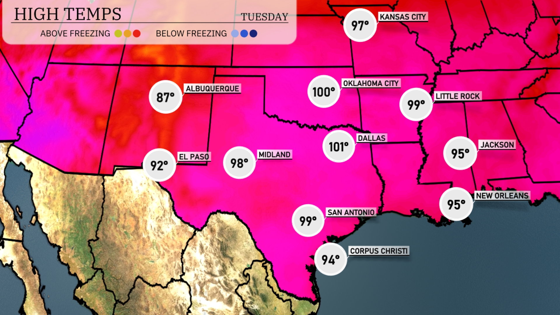
Tomorrow in El Paso, expect a high of 92 degrees, while Midland heats up to a steamy 98. San Antonio will reach 99, staying warm through the late afternoon. Dallas is forecasted to hit 101 degrees, reflecting above-average temperatures for this time of year. New Orleans and Jackson will both see highs around 95 degrees, typical for summer in the region.
A cold front approaches the Southern Plains, triggering storms from Dallas to Oklahoma City. Be prepared for potential severe weather, including damaging winds and heavy rainfall. Expect increasing thunderstorms especially in the afternoon, with Oklahoma potentially seeing the strongest activity. Rainfall may relieve dry conditions in places like Corpus Christi, but could lead to localized flooding. Temperatures will drop post-front passage, bringing cooler air into Tuesday and clearing out most precipitation by late evening.
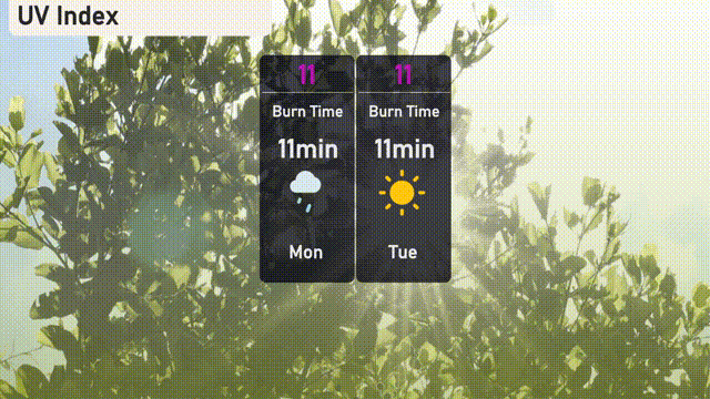
The UV index in Austin is reaching a very high level of 11 on both Monday and Tuesday, leading to a potential sunburn in just 11 minutes. Use extra caution if you’re outdoors, especially during midday when the sun is most intense. Remember to apply broad-spectrum sunscreen, wear a hat, and seek shade when possible to protect your skin!
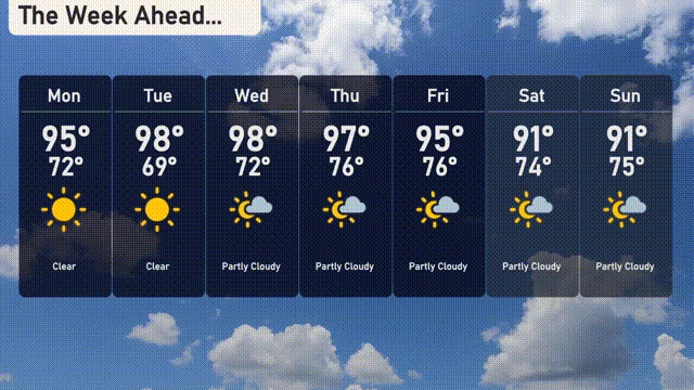
For the 7-day forecast in Austin:
Monday: Expect clear skies with a high of 95 degrees and a low of 72 degrees.
Tuesday: Sunny and very warm with a high reaching 98 degrees, the low is 69 degrees.
Wednesday: Partly cloudy, with highs around 98 degrees and lows near 72 degrees.
Thursday: Partly cloudy again with temperatures peaking at 97 degrees and a nighttime low of 76 degrees.
Friday: A mix of clouds and sunshine with the temperature reaching a high of 95 degrees and a low of 76 degrees.
Saturday: Partly cloudy with a high of 91 degrees and a low of 74 degrees.
Sunday: Partly cloudy continues, with the day heating up to 91 degrees and cooling down to 75 degrees at night.
Stay safe and enjoy the week ahead!